

Climate of Florida
Encyclopedia
The climate of North and Central Florida
is humid subtropical. South Florida has a tropical climate. There is a defined rainy season from June through September, which are the months most at risk of landfalling tropical cyclone
s. Thunderstorm
s, through lightning
, lead to several deaths per year statewide. Florida is one of the most tornado-prone states in the United States
. During mid summer, dust emanating from Africa affects the state, turning skies white and decreasing air quality.
Between October and May, fronts regularly sweep through the state which keeps conditions dry, particularly over the peninsula. Towards the end of the dry season
in the spring, brush fires become common statewide. In winters where an El Niño climate cycle exists, rainfall increases while temperatures are cooler statewide. In North Florida, snow and sleet have been witnessed as early as November and as late as April, though most areas do not experience any frozen precipitation during a typical year. Easterly winds off the warm waters of the Gulf Stream
running through the Florida Straits keep temperatures moderate across the southern peninsula year round.
was 28.84 inches/976.7 hPa during the Storm of the Century (1993). From a tropical cyclone, the lowest pressure measured was 26.35 inches/892 hPa in the Florida Keys
during the Labor Day Hurricane of 1935
. The highest known pressure measured statewide was 30.74 inches/1041.1 hPa in Tallahassee on February 5, 1996 and January 4, 1979.
, out of the west at Gainesville
and Jacksonville
, and generally out of the east elsewhere. During the summer months, the average wind pattern implies a surface ridge axis normally lies across central Florida, with easterly winds from Tampa
southward and southwest winds across northern Florida, once Orlando is not considered for the distribution. The peak wind gust during the 1930 through 1997 period was 115 mph/100 knots at Miami International Airport
during Hurricane Andrew
.
 July is the month where the tradewinds south of the northward-moving subtropical ridge
expand northwestward into Florida. Dust from the Sahara
moving around the southern periphery of the ridge moves into the state, suppressing rainfall and changing the sky from a blue to a white appearance and leads to an increase in red sunsets. Its presence negatively impacts air quality across the Southeastern United States
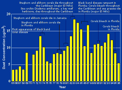
during the summer, by adding to the count of airborne particulates. Over 50% of the African dust that reaches the United States affects Florida. Since 1970, dust outbreaks have worsened due to periods of drought in Africa. There is a large variability in the dust transport to the Caribbean and Florida from year to year. Dust events have been linked to a decline in the health of coral reef
s across the Caribbean and Florida, primarily since the 1970s.
in January to 65 °F (18.3 °C) in Key West
while daytime highs range from 64 °F (17.8 °C) at Tallahassee to 77 °F (25 °C) at Miami. Predominant easterly winds across southern Florida keep temperatures moderate during the winter, as the nearby Gulf Stream modifies cooler air moving in from the northeast and east. El Niño winters tend to be cooler due to increased cloud cover, but tend to have fewer freezes. Despite its warm, southern location, there have been freezes detrimental to citrus production in North and Central Florida's history in the years 1835, 1894–1895, 1899, 1917, 1934, 1940, 1957, 1962, 1977, 1981, 1983, 1985, 1986, 1989, and 2010. The record low temperature for Florida was -2 °F at Tallahassee in 1899. In February 2010, the USDA declared that 59 (out of 67) Florida counties were "primary natural disaster areas." This happened when the temperature falls below 28 degrees for 4 hours, where crops are being grown.
Three "hardiness" zones exist. The warmest is South Florida, but includes Tampa, Melbourne and Orlando. Low temperatures range from 30 to 40 °F (-1.1 to 4.4 C). Next is Central and North Florida with the above exclusions and includes Jacksonville, Gainesville, and Pensacola. Low temperatures range from 20 to 30 °F (-6.7 to -1.1 C). The coolest is a relatively small area in northern Florida including Tallahassee. Low temperatures range from 10 to 20 °F (-12.2 to -6.7 C).
 During the summer, minima range from near 70 °F (21.1 °C) in northern Florida to near 80 °F (26.7 °C) in the Keys. High temperatures during the summer average in the lower 90s Fahrenheit statewide. Relief from the heat during the summer comes in the form of afternoon and evening thunderstorm activity, late morning and afternoon sea breezes off the relatively cooler ocean, and during the passage of a tropical cyclone. The passage of a cold front through the state is rare during the warm season. The record high temperature for the state is 109 °F (42.8 °C) at Monticello in 1931.
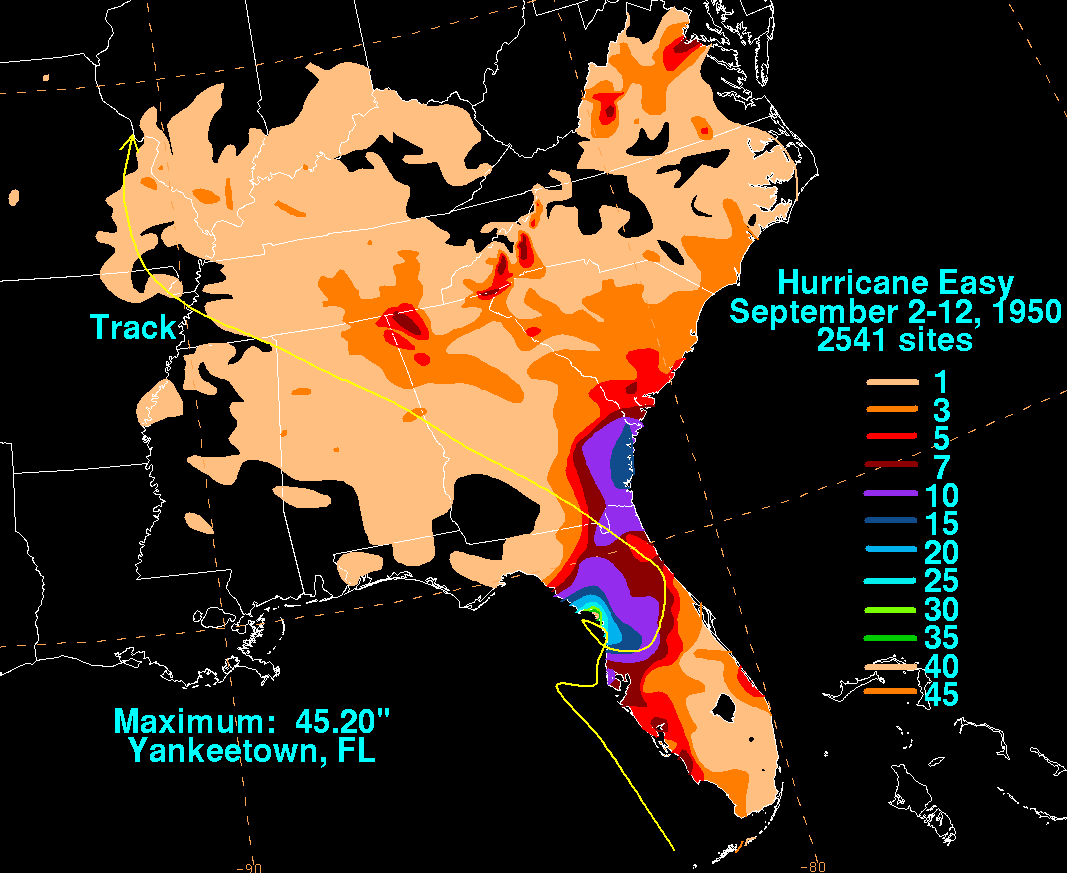 The heaviest rainfall to occur in 24 hours was measured in Yankeetown during Hurricane Easy (1950)
, 38.7 inches (98.3 cm). This is also the highest known point storm total maximum related to any tropical cyclone which has impacted Florida, and by itself would be the highest known rainfall total for any month from any location within Florida. This rainfall amount remained the national 24-hour rainfall record until Tropical Storm Claudette (1979)
. Heavy rainfall events have fallen due to stalled fronts near the state as well, and occur during the March through May and October through November timeframe.
The wettest month recorded at a Florida climate station was during May 1891 when Gainesville, Florida
received 30.9 inches (78.5 cm). The wettest year on record for a Florida climate station was during 1879 when 127.24 inches (323.2 cm) fell at Pensacola, Florida
. The driest year for a climate station statewide was during 1974 when only 19.99 inches (50.8 cm) fell at Key West.
One of the worst years for wildfires was in 1998, at the end of an El Nino cycle. 480 wildfires consumed 500000 acres (2,023.4 km²) statewide. In 2010, the National Weather Service
issued more fire alerts in Florida than anywhere else in the nation. In 2011, they are raising their criteria in order to drop the number reported to 1/15 of those reported in the past.
A statewide drought existed until 2009, that began in November 2005, a month after Hurricane Wilma
's passage through the state. The previous significant drought occurred in 2000, which was the state's driest year on record.
The state record for snowfall is 5 inches (12.7 cm), set in northern Florida during January 1800. The earliest in the season that frozen precipitation has fallen was during the Late November 2006 Nor'easter
on November 21 across central Florida. The latest in the season that snow or sleet has fallen was on April 8, 2007. A trace of snowfall has been recorded as far south as Homestead
, mainly during a January 19, 1977 event.
. Several deaths per year are blamed on lightning, making lightning one of the deadliest weather-related phenomenon in the state. However, since 1992, the number of lightning deaths has been slowly dropping despite a rising population, suggesting that lightning awareness programs are effective. The most likely targets of lightning strikes are construction workers and others who work outside, though 12 percent of the cases occurred indoors to people using electronic devices.

The earliest a tropical cyclone has struck the sunshine state was the Groundhog Day Tropical Storm in 1952. The latest impact was from a hurricane which struck near Tampa on December 1, 1925. The strongest hurricane to strike Florida was the Labor Day Hurricane of 1935
. Hurricane Easy in 1950 produced the wettest known point total from any tropical cyclone. The record number of hurricane strikes on the state in one season is four in 2004. Hurricanes typically spawn tornadoes within their northeast quadrant.
Tropical cyclones have affected Florida in every month of the year but January and March. Nearly one-third of the cyclones affected the state in September, and nearly three-fourths of the storms affected the state between August and October, which coincides with the peak of the hurricane season. Portions of the coastline have the lowest return period, or the frequency at which a certain intensity or category of hurricane can be expected within 86 mi (139 km) of a given location, in the country. Monroe County
was struck by 26 hurricanes since 1926
, which is the greatest total for any county in the United States
.
La Niña
has the following effects: often dry conditions prevail in late fall, winter and early spring, increased risk of wildfires in spring and summer months, the temperatures average slightly above normal, and the chance of hurricane activity increases substantially.
Long term forecasts are made based on these effects. However, they are easily overridden, in winter, by the Arctic oscillation
and North Atlantic oscillation
s, which can only be predicted about two weeks in advance. These can drop the temperature noticeably from seasonal norms.
(Koppen Cfa), though portions of the Gold Coast of southeast Florida, as well as all of the Florida Keys, qualify as tropical wet-and-dry
(Koppen Aw).
A narrow eastern part of the state including Orlando and Jacksonville receives between 2,400 and 2,800 hours of sunshine
annually. The rest of the state, including Miami, receives between 2,800 and 3,200 hours annually.
Florida
Florida is a state in the southeastern United States, located on the nation's Atlantic and Gulf coasts. It is bordered to the west by the Gulf of Mexico, to the north by Alabama and Georgia and to the east by the Atlantic Ocean. With a population of 18,801,310 as measured by the 2010 census, it...
is humid subtropical. South Florida has a tropical climate. There is a defined rainy season from June through September, which are the months most at risk of landfalling tropical cyclone
Tropical cyclone
A tropical cyclone is a storm system characterized by a large low-pressure center and numerous thunderstorms that produce strong winds and heavy rain. Tropical cyclones strengthen when water evaporated from the ocean is released as the saturated air rises, resulting in condensation of water vapor...
s. Thunderstorm
Thunderstorm
A thunderstorm, also known as an electrical storm, a lightning storm, thundershower or simply a storm is a form of weather characterized by the presence of lightning and its acoustic effect on the Earth's atmosphere known as thunder. The meteorologically assigned cloud type associated with the...
s, through lightning
Lightning
Lightning is an atmospheric electrostatic discharge accompanied by thunder, which typically occurs during thunderstorms, and sometimes during volcanic eruptions or dust storms...
, lead to several deaths per year statewide. Florida is one of the most tornado-prone states in the United States
United States
The United States of America is a federal constitutional republic comprising fifty states and a federal district...
. During mid summer, dust emanating from Africa affects the state, turning skies white and decreasing air quality.
Between October and May, fronts regularly sweep through the state which keeps conditions dry, particularly over the peninsula. Towards the end of the dry season
Dry season
The dry season is a term commonly used when describing the weather in the tropics. The weather in the tropics is dominated by the tropical rain belt, which oscillates from the northern to the southern tropics over the course of the year...
in the spring, brush fires become common statewide. In winters where an El Niño climate cycle exists, rainfall increases while temperatures are cooler statewide. In North Florida, snow and sleet have been witnessed as early as November and as late as April, though most areas do not experience any frozen precipitation during a typical year. Easterly winds off the warm waters of the Gulf Stream
Gulf Stream
The Gulf Stream, together with its northern extension towards Europe, the North Atlantic Drift, is a powerful, warm, and swift Atlantic ocean current that originates at the tip of Florida, and follows the eastern coastlines of the United States and Newfoundland before crossing the Atlantic Ocean...
running through the Florida Straits keep temperatures moderate across the southern peninsula year round.
Pressure
The low pressure measured from an extratropical cycloneExtratropical cyclone
Extratropical cyclones, sometimes called mid-latitude cyclones or wave cyclones, are a group of cyclones defined as synoptic scale low pressure weather systems that occur in the middle latitudes of the Earth having neither tropical nor polar characteristics, and are connected with fronts and...
was 28.84 inches/976.7 hPa during the Storm of the Century (1993). From a tropical cyclone, the lowest pressure measured was 26.35 inches/892 hPa in the Florida Keys
Florida Keys
The Florida Keys are a coral archipelago in southeast United States. They begin at the southeastern tip of the Florida peninsula, about south of Miami, and extend in a gentle arc south-southwest and then westward to Key West, the westernmost of the inhabited islands, and on to the uninhabited Dry...
during the Labor Day Hurricane of 1935
Labor Day Hurricane of 1935
The 1935 Labor Day Hurricane was the strongest tropical cyclone of the 1935 Atlantic hurricane season, and one of the most intense hurricanes to make landfall in the United States in recorded history...
. The highest known pressure measured statewide was 30.74 inches/1041.1 hPa in Tallahassee on February 5, 1996 and January 4, 1979.
Wind
Over the entire year, winds average out of the north across the panhandle and near OrlandoOrlando, Florida
Orlando is a city in the central region of the U.S. state of Florida. It is the county seat of Orange County, and the center of the Greater Orlando metropolitan area. According to the 2010 US Census, the city had a population of 238,300, making Orlando the 79th largest city in the United States...
, out of the west at Gainesville
Gainesville, Florida
Gainesville is the largest city in, and the county seat of, Alachua County, Florida, United States as well as the principal city of the Gainesville, Florida Metropolitan Statistical Area . The preliminary 2010 Census population count for Gainesville is 124,354. Gainesville is home to the sixth...
and Jacksonville
Jacksonville, Florida
Jacksonville is the largest city in the U.S. state of Florida in terms of both population and land area, and the largest city by area in the contiguous United States. It is the county seat of Duval County, with which the city government consolidated in 1968...
, and generally out of the east elsewhere. During the summer months, the average wind pattern implies a surface ridge axis normally lies across central Florida, with easterly winds from Tampa
Tampa, Florida
Tampa is a city in the U.S. state of Florida. It serves as the county seat for Hillsborough County. Tampa is located on the west coast of Florida. The population of Tampa in 2010 was 335,709....
southward and southwest winds across northern Florida, once Orlando is not considered for the distribution. The peak wind gust during the 1930 through 1997 period was 115 mph/100 knots at Miami International Airport
Miami International Airport
Miami International Airport , also known as MIA and historically Wilcox Field, is the primary airport serving the South Florida area...
during Hurricane Andrew
Hurricane Andrew
Hurricane Andrew was the third Category 5 hurricane to make landfall in the United States, after the Labor Day Hurricane of 1935 and Hurricane Camille in 1969. Andrew was the first named storm and only major hurricane of the otherwise inactive 1992 Atlantic hurricane season...
.
African dust outbreaks
Subtropical ridge
The subtropical ridge is a significant belt of high pressure situated around the latitudes of 30°N in the Northern Hemisphere and 30°S in the Southern Hemisphere. It is characterized by mostly calm winds, which acts to reduce air quality under its axis by causing fog overnight, and haze during...
expand northwestward into Florida. Dust from the Sahara
Sahara
The Sahara is the world's second largest desert, after Antarctica. At over , it covers most of Northern Africa, making it almost as large as Europe or the United States. The Sahara stretches from the Red Sea, including parts of the Mediterranean coasts, to the outskirts of the Atlantic Ocean...
moving around the southern periphery of the ridge moves into the state, suppressing rainfall and changing the sky from a blue to a white appearance and leads to an increase in red sunsets. Its presence negatively impacts air quality across the Southeastern United States
Southeastern United States
The Southeastern United States, colloquially referred to as the Southeast, is the eastern portion of the Southern United States. It is one of the most populous regions in the United States of America....
during the summer, by adding to the count of airborne particulates. Over 50% of the African dust that reaches the United States affects Florida. Since 1970, dust outbreaks have worsened due to periods of drought in Africa. There is a large variability in the dust transport to the Caribbean and Florida from year to year. Dust events have been linked to a decline in the health of coral reef
Coral reef
Coral reefs are underwater structures made from calcium carbonate secreted by corals. Coral reefs are colonies of tiny living animals found in marine waters that contain few nutrients. Most coral reefs are built from stony corals, which in turn consist of polyps that cluster in groups. The polyps...
s across the Caribbean and Florida, primarily since the 1970s.
Winter
On average, wintertime lows dip down to near 39 °F (3.9 °C) degrees Fahrenheit at TallahasseeTallahassee, Florida
Tallahassee is the capital of the U.S. state of Florida. It is the county seat and only incorporated municipality in Leon County, and is the 128th largest city in the United States. Tallahassee became the capital of Florida, then the Florida Territory, in 1824. In 2010, the population recorded by...
in January to 65 °F (18.3 °C) in Key West
Key West, Florida
Key West is a city in Monroe County, Florida, United States. The city encompasses the island of Key West, the part of Stock Island north of U.S. 1 , Sigsbee Park , Fleming Key , and Sunset Key...
while daytime highs range from 64 °F (17.8 °C) at Tallahassee to 77 °F (25 °C) at Miami. Predominant easterly winds across southern Florida keep temperatures moderate during the winter, as the nearby Gulf Stream modifies cooler air moving in from the northeast and east. El Niño winters tend to be cooler due to increased cloud cover, but tend to have fewer freezes. Despite its warm, southern location, there have been freezes detrimental to citrus production in North and Central Florida's history in the years 1835, 1894–1895, 1899, 1917, 1934, 1940, 1957, 1962, 1977, 1981, 1983, 1985, 1986, 1989, and 2010. The record low temperature for Florida was -2 °F at Tallahassee in 1899. In February 2010, the USDA declared that 59 (out of 67) Florida counties were "primary natural disaster areas." This happened when the temperature falls below 28 degrees for 4 hours, where crops are being grown.
Three "hardiness" zones exist. The warmest is South Florida, but includes Tampa, Melbourne and Orlando. Low temperatures range from 30 to 40 °F (-1.1 to 4.4 C). Next is Central and North Florida with the above exclusions and includes Jacksonville, Gainesville, and Pensacola. Low temperatures range from 20 to 30 °F (-6.7 to -1.1 C). The coolest is a relatively small area in northern Florida including Tallahassee. Low temperatures range from 10 to 20 °F (-12.2 to -6.7 C).
Summer
Fog
Like the remainder of the Southeastern United States, Florida has a winter maximum in dense fog conditions. Unlike the remainder of the region, the maximum in Florida contains roughly half of the annual occurrences per year, on average. Its summer minimum is also less than the remainder of the Southeast. There has been no noticeable increase or decrease in fog across Florida, over the past several decades.Liquid precipitation equivalent
Averages
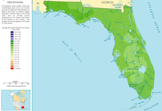
Statewide, the highest rainfall amounts occur during the summer months. In northern Florida, there is a weak winter secondary maximum while statewide the driest months of the year are during the spring. During El Niño, Florida sees greater rainfall between November and March. Due to the lack of the secondary maximum across the peninsula, a distinct dry season is seen in the averages from winter through spring. This dry season provokes brush fires annually as temperatures rise during the late spring, before they fade during early June as the rainy season gets underway.Extremes
Hurricane Easy (1950)
Hurricane Easy was the fifth tropical storm, hurricane, and major hurricane of the 1950 Atlantic hurricane season. The hurricane developed in the western Caribbean Sea on September 1, and tracked northeastward. After crossing Cuba, the hurricane rapidly strengthened in the eastern Gulf of Mexico to...
, 38.7 inches (98.3 cm). This is also the highest known point storm total maximum related to any tropical cyclone which has impacted Florida, and by itself would be the highest known rainfall total for any month from any location within Florida. This rainfall amount remained the national 24-hour rainfall record until Tropical Storm Claudette (1979)
Tropical Storm Claudette (1979)
Tropical Storm Claudette was a long living tropical storm that produced heavy rain across Puerto Rico and Texas in late July 1979. The storm killed 2 people and left $1.1 billion in damage...
. Heavy rainfall events have fallen due to stalled fronts near the state as well, and occur during the March through May and October through November timeframe.
The wettest month recorded at a Florida climate station was during May 1891 when Gainesville, Florida
Gainesville, Florida
Gainesville is the largest city in, and the county seat of, Alachua County, Florida, United States as well as the principal city of the Gainesville, Florida Metropolitan Statistical Area . The preliminary 2010 Census population count for Gainesville is 124,354. Gainesville is home to the sixth...
received 30.9 inches (78.5 cm). The wettest year on record for a Florida climate station was during 1879 when 127.24 inches (323.2 cm) fell at Pensacola, Florida
Pensacola, Florida
Pensacola is the westernmost city in the Florida Panhandle and the county seat of Escambia County, Florida, United States of America. As of the 2000 census, the city had a total population of 56,255 and as of 2009, the estimated population was 53,752...
. The driest year for a climate station statewide was during 1974 when only 19.99 inches (50.8 cm) fell at Key West.
One of the worst years for wildfires was in 1998, at the end of an El Nino cycle. 480 wildfires consumed 500000 acres (2,023.4 km²) statewide. In 2010, the National Weather Service
National Weather Service
The National Weather Service , once known as the Weather Bureau, is one of the six scientific agencies that make up the National Oceanic and Atmospheric Administration of the United States government...
issued more fire alerts in Florida than anywhere else in the nation. In 2011, they are raising their criteria in order to drop the number reported to 1/15 of those reported in the past.
A statewide drought existed until 2009, that began in November 2005, a month after Hurricane Wilma
Hurricane Wilma
Hurricane Wilma was the most intense tropical cyclone ever recorded in the Atlantic basin. Wilma was the twenty-second storm , thirteenth hurricane, sixth major hurricane, and fourth Category 5 hurricane of the record-breaking 2005 season...
's passage through the state. The previous significant drought occurred in 2000, which was the state's driest year on record.
Snowfall
The earliest recorded occurrence of snow or sleet occurred in 1774. The latest occurrence of snow or sleet in the spring fell on January 7,8,and 9th 2010, as a cold front brought scattered snow flurries along with widespread sleet and freezing rain, especially in the northern and central portions of the state.The state record for snowfall is 5 inches (12.7 cm), set in northern Florida during January 1800. The earliest in the season that frozen precipitation has fallen was during the Late November 2006 Nor'easter
Late November 2006 Nor'easter
The Late November 2006 Nor'easter was an extratropical cyclone that formed offshore the Southeast United States on November 20, bringing heavy rains, high winds, beach erosion, and coastal flooding to the Carolinas and southern New England...
on November 21 across central Florida. The latest in the season that snow or sleet has fallen was on April 8, 2007. A trace of snowfall has been recorded as far south as Homestead
Homestead, Florida
Homestead is a city in Miami-Dade County, Florida, United States nestled between Biscayne National Park to the east and Everglades National Park to the west. Homestead is primarily a Miami suburb and a major agricultural area....
, mainly during a January 19, 1977 event.
Thunderstorms
Florida receives the highest density of lightning strikes within the United StatesUnited States
The United States of America is a federal constitutional republic comprising fifty states and a federal district...
. Several deaths per year are blamed on lightning, making lightning one of the deadliest weather-related phenomenon in the state. However, since 1992, the number of lightning deaths has been slowly dropping despite a rising population, suggesting that lightning awareness programs are effective. The most likely targets of lightning strikes are construction workers and others who work outside, though 12 percent of the cases occurred indoors to people using electronic devices.
Tornadoes
There are more tornadoes per square mile in Florida than any other state. However, these tornadoes tend to be much weaker and short-lived than in other states like the Midwest or Great Plains. There are fewer deaths and property damage than are experienced by some other states. Strong tornadoes do occasionally form in Florida, usually in conjunctions with a cold frontal passage in the winter or spring. A total of 42 people died in February 1998 from the deadliest such tornado outbreak in Central Florida, which occurred during the nighttime hours.Tropical cyclones
The earliest a tropical cyclone has struck the sunshine state was the Groundhog Day Tropical Storm in 1952. The latest impact was from a hurricane which struck near Tampa on December 1, 1925. The strongest hurricane to strike Florida was the Labor Day Hurricane of 1935
Labor Day Hurricane of 1935
The 1935 Labor Day Hurricane was the strongest tropical cyclone of the 1935 Atlantic hurricane season, and one of the most intense hurricanes to make landfall in the United States in recorded history...
. Hurricane Easy in 1950 produced the wettest known point total from any tropical cyclone. The record number of hurricane strikes on the state in one season is four in 2004. Hurricanes typically spawn tornadoes within their northeast quadrant.
Tropical cyclones have affected Florida in every month of the year but January and March. Nearly one-third of the cyclones affected the state in September, and nearly three-fourths of the storms affected the state between August and October, which coincides with the peak of the hurricane season. Portions of the coastline have the lowest return period, or the frequency at which a certain intensity or category of hurricane can be expected within 86 mi (139 km) of a given location, in the country. Monroe County
Monroe County, Florida
Monroe County is a county located in the state of Florida. As of 2000, the population was 79,589. The U.S. Census Bureau 2006 estimate for the county was 74,737....
was struck by 26 hurricanes since 1926
1926 Atlantic hurricane season
A Cape Verde-type hurricane reached Category 4 strength over the open Atlantic Ocean on September. It turned to the northeast, looped, and became extratropical on September 21...
, which is the greatest total for any county in the United States
United States
The United States of America is a federal constitutional republic comprising fifty states and a federal district...
.
Effect of climate cycles
El Niño has the following effects on Florida climate: above average rainfall in the spring. This is followed by wildfire threat when rain dries up. Northern Florida is more susceptible to severe weather; below normal temperatures, increased number of low pressure systems in the Gulf of Mexico during the winter, and "almost always" reduces the frequency of storms and hurricanes.La Niña
La Niña
La Niña is a coupled ocean-atmosphere phenomenon that is the counterpart of El Niño as part of the broader El Niño-Southern Oscillation climate pattern. During a period of La Niña, the sea surface temperature across the equatorial Eastern Central Pacific Ocean will be lower than normal by 3–5 °C...
has the following effects: often dry conditions prevail in late fall, winter and early spring, increased risk of wildfires in spring and summer months, the temperatures average slightly above normal, and the chance of hurricane activity increases substantially.
Long term forecasts are made based on these effects. However, they are easily overridden, in winter, by the Arctic oscillation
Arctic oscillation
The Arctic oscillation or Northern Annular Mode/Northern Hemisphere Annular Mode is an index of the dominant pattern of non-seasonal sea-level pressure variations north of 20N latitude, and it is characterized by pressure anomalies of one sign in the Arctic with the opposite anomalies centered...
and North Atlantic oscillation
North Atlantic oscillation
The North Atlantic oscillation is a climatic phenomenon in the North Atlantic Ocean of fluctuations in the difference of atmospheric pressure at sea level between the Icelandic low and the Azores high. Through east-west oscillation motions of the Icelandic low and the Azores high, it controls the...
s, which can only be predicted about two weeks in advance. These can drop the temperature noticeably from seasonal norms.
Climates of selected Florida cities
The climate regime for much of the state is humid subtropicalHumid subtropical climate
A humid subtropical climate is a climate zone characterized by hot, humid summers and mild to cool winters...
(Koppen Cfa), though portions of the Gold Coast of southeast Florida, as well as all of the Florida Keys, qualify as tropical wet-and-dry
Tropical savanna climate
Tropical savanna climate or tropical wet and dry climate is a type of climate that corresponds to the Köppen climate classification categories "Aw" and '"As."...
(Koppen Aw).
A narrow eastern part of the state including Orlando and Jacksonville receives between 2,400 and 2,800 hours of sunshine
Sunshine
Sunshine is sunlight, the electromagnetic radiation emitted by the Sun, especially in the visible wavelengths.Sunshine may also refer to:-Film and television:*Sunshine , a historical film directed by István Szabó...
annually. The rest of the state, including Miami, receives between 2,800 and 3,200 hours annually.
See also
- ClimateClimateClimate encompasses the statistics of temperature, humidity, atmospheric pressure, wind, rainfall, atmospheric particle count and other meteorological elemental measurements in a given region over long periods...
- ClimatologyClimatologyClimatology is the study of climate, scientifically defined as weather conditions averaged over a period of time, and is a branch of the atmospheric sciences...
- List of wettest known tropical cyclones in Florida
- Climate of MiamiClimate of MiamiMiami has a tropical monsoon climate with hot and humid summers and short, warm winters, with a marked drier season in the winter. Its sea-level elevation, coastal location, position just above the Tropic of Cancer, and proximity to the Gulf Stream shape its climate...
- Climate of the Tampa Bay AreaClimate of the Tampa Bay AreaThe Tampa Bay area has a humid subtropical climate , with warm and humid summers with frequent thunderstorms and drier winters with freezing temperatures occurring every 2–3 years. The area experiences a significant summer wet season, as nearly two-thirds of the annual precipitation falls in the...