

Climate of California
Encyclopedia
California
California is a state located on the West Coast of the United States. It is by far the most populous U.S. state, and the third-largest by land area...
's climate varies widely, from arid
Arid
A region is said to be arid when it is characterized by a severe lack of available water, to the extent of hindering or even preventing the growth and development of plant and animal life...
to subarctic
Subarctic
The Subarctic is a region in the Northern Hemisphere immediately south of the true Arctic and covering much of Alaska, Canada, the north of Scandinavia, Siberia, and northern Mongolia...
, depending on latitude
Latitude
In geography, the latitude of a location on the Earth is the angular distance of that location south or north of the Equator. The latitude is an angle, and is usually measured in degrees . The equator has a latitude of 0°, the North pole has a latitude of 90° north , and the South pole has a...
, elevation
Elevation
The elevation of a geographic location is its height above a fixed reference point, most commonly a reference geoid, a mathematical model of the Earth's sea level as an equipotential gravitational surface ....
, and proximity to the coast. Coastal and Southern parts of the state have a Mediterranean climate
Mediterranean climate
A Mediterranean climate is the climate typical of most of the lands in the Mediterranean Basin, and is a particular variety of subtropical climate...
, with somewhat rainy winters and dry summers. The influence of the ocean
Ocean
An ocean is a major body of saline water, and a principal component of the hydrosphere. Approximately 71% of the Earth's surface is covered by ocean, a continuous body of water that is customarily divided into several principal oceans and smaller seas.More than half of this area is over 3,000...
generally moderates temperature extremes, creating warmer winters and substantially cooler summers, especially along the coastal areas.
Temperature range
The cool California CurrentCalifornia Current
The California Current is a Pacific Ocean current that moves south along the western coast of North America, beginning off southern British Columbia, and ending off southern Baja California. There are five major coastal currents affiliated with upwelling zones...
offshore, enhanced by upwelling
Upwelling
Upwelling is an oceanographic phenomenon that involves wind-driven motion of dense, cooler, and usually nutrient-rich water towards the ocean surface, replacing the warmer, usually nutrient-depleted surface water. The increased availability in upwelling regions results in high levels of primary...
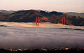
of cold sub-surface waters, often creates summer fog
Fog
Fog is a collection of water droplets or ice crystals suspended in the air at or near the Earth's surface. While fog is a type of stratus cloud, the term "fog" is typically distinguished from the more generic term "cloud" in that fog is low-lying, and the moisture in the fog is often generated...
near the coast, creating a moderate oceanic climate
Oceanic climate
An oceanic climate, also called marine west coast climate, maritime climate, Cascadian climate and British climate for Köppen climate classification Cfb and subtropical highland for Köppen Cfb or Cwb, is a type of climate typically found along the west coasts at the middle latitudes of some of the...
(Köppen climate classification
Köppen climate classification
The Köppen climate classification is one of the most widely used climate classification systems. It was first published by Crimea German climatologist Wladimir Köppen in 1884, with several later modifications by Köppen himself, notably in 1918 and 1936...
Cfb) on the northern coast and a moderate Mediterranean climate
Mediterranean climate
A Mediterranean climate is the climate typical of most of the lands in the Mediterranean Basin, and is a particular variety of subtropical climate...
(Köppen Csb) from about Cape Mendocino
Cape Mendocino
Cape Mendocino located on the Lost Coast entirely within Humboldt County, California, USA, is the westernmost point on the coast of California. It has been a landmark since the 16th century when the Manila Galleons would reach the coast here following the prevailing westerlies all the way across...
southward. Further inland, the climate becomes more continental
Continental climate
Continental climate is a climate characterized by important annual variation in temperature due to the lack of significant bodies of water nearby...
, with some areas turningsemi-arid
Semi-arid
A semi-arid climate or steppe climate describes climatic regions that receive precipitation below potential evapotranspiration, but not extremely...
(Köppen BSk), with colder winters and markedly hotter summers. Low-lying inland valleys, especially the Central Valley, have a hot Mediterranean climate (Köppen Csa), with subtropical temperatures but a well-defined summer dry season and cool, foggy, rainy season.
The temperature gradient between immediate coast and low-lying inland valleys in the south is about 7 °F (4 °C) in winter (the coast being warmer) and in summer roughly 25 °F (14 °C) (the interior being warmer). One exception is worth noting - during the cooler winter months (Oct-Mar) the Coachella Valley, in the far southeastern corner of the State, constantly has the warmest winter temperatures out of any place west of the Rocky Mountains. Palm Springs a city in the Coachella Valley averages high/low/mean temperatures of 75°F/50°F/63°F, (24°C/10°C/17°C) respectively during the period of cooler weather form Nov. to Apr. The temperature difference is most dramatic nearer the coast. For example, the average daily high in San Francisco
San Francisco, California
San Francisco , officially the City and County of San Francisco, is the financial, cultural, and transportation center of the San Francisco Bay Area, a region of 7.15 million people which includes San Jose and Oakland...
in July and August is 72 °F (22.2 °C), and in Walnut Creek
Walnut Creek, California
Walnut Creek is an incorporated city located east of the city of Oakland. It lies in the East Bay region of the San Francisco Bay Area. While not as large as neighboring Concord, Walnut Creek serves as the business and entertainment hub for the neighboring cities within central Contra Costa...
, some 20 miles (32 km) inland, the average daily high in July and August is 90 °F (32.2 °C); a temperature gain of approximately one degree (Fahrenheit) per mile. In the south, the figures are approximately 4 °F and 23 °F (2 °C and 13 °C), respectively. At the Santa Monica
Santa Monica, California
Santa Monica is a beachfront city in western Los Angeles County, California, US. Situated on Santa Monica Bay, it is surrounded on three sides by the city of Los Angeles — Pacific Palisades on the northwest, Brentwood on the north, West Los Angeles on the northeast, Mar Vista on the east, and...
coast, the average high in August is 75 °F (23.9 °C), while in Burbank
Burbank, California
Burbank is a city in Los Angeles County in Southern California, United States, north of downtown Los Angeles. The estimated population in 2010 was 103,340....
, approximately 10 miles (16.1 km) inland, the average high in August is 90 °F (32.2 °C); a temperature gain over one degree per mile. The temperature gradient is most extreme between Santa Barbara
Santa Barbara, California
Santa Barbara is the county seat of Santa Barbara County, California, United States. Situated on an east-west trending section of coastline, the longest such section on the West Coast of the United States, the city lies between the steeply-rising Santa Ynez Mountains and the Pacific Ocean...
and Death Valley
Death Valley
Death Valley is a desert valley located in Eastern California. Situated within the Mojave Desert, it features the lowest, driest, and hottest locations in North America. Badwater, a basin located in Death Valley, is the specific location of the lowest elevation in North America at 282 feet below...
, with temperatures between the two differing by 4 °F and 35 °F (2 °C and 20 °C) in the winter and summer. The extreme southwest, around San Diego
San Diego, California
San Diego is the eighth-largest city in the United States and second-largest city in California. The city is located on the coast of the Pacific Ocean in Southern California, immediately adjacent to the Mexican border. The birthplace of California, San Diego is known for its mild year-round...
, has a semi-arid warm steppe climate (Koppen BSh) as winters are drier there. In San Bernardino
San Bernardino, California
San Bernardino is a city located in the Riverside-San Bernardino metropolitan area , and serves as the county seat of San Bernardino County, California, United States...
the winters get a low of 30 °F (-1.1 °C) and in the summers a high of 109 °F (42.8 °C) since it is about 70 miles (112.7 km) inland of the Pacific Ocean in Southern California.
The southeastern regions have a hot arid
Arid
A region is said to be arid when it is characterized by a severe lack of available water, to the extent of hindering or even preventing the growth and development of plant and animal life...
climate (Koppen BWh), similar to that of the Sahara Desert. In the northern portion of the Mojave Desert
Mojave Desert
The Mojave Desert occupies a significant portion of southeastern California and smaller parts of central California, southern Nevada, southwestern Utah and northwestern Arizona, in the United States...
on the east side of the state is Death Valley
Death Valley
Death Valley is a desert valley located in Eastern California. Situated within the Mojave Desert, it features the lowest, driest, and hottest locations in North America. Badwater, a basin located in Death Valley, is the specific location of the lowest elevation in North America at 282 feet below...
, which is the hottest spot on the Western Hemisphere
Western Hemisphere
The Western Hemisphere or western hemisphere is mainly used as a geographical term for the half of the Earth that lies west of the Prime Meridian and east of the Antimeridian , the other half being called the Eastern Hemisphere.In this sense, the western hemisphere consists of the western portions...
. It is common in the summer for temperatures in the valley to reach 120 °F (48.9 °C). The highest temperature in the Western Hemisphere, 134 °F (56.7 °C), was recorded in Death Valley on July 10, 1913. Temperatures of 130 °F (54.4 °C) or higher have been recorded as recently as 2005. The 24-hour average July temperature in Death Valley is 101.8 °F (38.8 °C) (1981-2010 NCDC Normals).
| City | Jan | Feb | Mar | Apr | May | Jun | Jul | Aug | Sep | Oct | Nov | Dec |
|---|---|---|---|---|---|---|---|---|---|---|---|---|
| Bakersfield | 57/39 (57 °F (13.9 °C)/39 °F (3.9 °C)) |
64/42 (64 °F (17.8 °C)/42 °F (5.6 °C)) |
70/46 (70 °F (21.1 °C)/46 °F (7.8 °C)) |
76/49 (76 °F (24.4 °C)/49 °F (9.4 °C)) |
84/57 (84 °F (28.9 °C)/57 °F (13.9 °C)) |
92/63 (92 °F (33.3 °C)/63 °F (17.2 °C)) |
98/69 (98 °F (36.7 °C)/69 °F (20.6 °C)) |
96/68 (96 °F (35.6 °C)/68 °F (20 °C)) |
91/63 (91 °F (32.8 °C)/63 °F (17.2 °C)) |
80/54 (80 °F (26.7 °C)/54 °F (12.2 °C)) |
66/44 (66 °F (18.9 °C)/44 °F (6.7 °C)) |
57/38 (57 °F (13.9 °C)/38 °F (3.3 °C)) |
| Bodie Bodie, California Bodie is a ghost town in the Bodie Hills east of the Sierra Nevada mountain range in Mono County, California, United States, about 75 miles southeast of Lake Tahoe. It is located east-southeast of Bridgeport, at an elevation of 8379 feet . As Bodie Historic District, the U.S. Department of the... |
40/6 (40 °F (4.4 °C)/6 °F (-14.4 °C)) |
42/8 (42 °F (5.6 °C)/8 °F (-13.3 °C)) |
44/12 (44 °F (6.7 °C)/12 °F (-11.1 °C)) |
51/18 (51 °F (10.6 °C)/18 °F (-7.8 °C)) |
60/25 (60 °F (15.6 °C)/25 °F (-3.9 °C)) |
70/31 (70 °F (21.1 °C)/31 °F (-.6 °C)) |
77/35 (77 °F (25 °C)/35 °F (1.7 °C)) |
76/34 (76 °F (24.4 °C)/34 °F (1.1 °C)) |
70/27 (70 °F (21.1 °C)/27 °F (-2.8 °C)) |
60/19 (60 °F (15.6 °C)/19 °F (-7.2 °C)) |
48/12 (48 °F (8.9 °C)/12 °F (-11.1 °C)) |
41/6 (41 °F (5 °C)/6 °F (-14.4 °C)) |
| Death Valley Death Valley Death Valley is a desert valley located in Eastern California. Situated within the Mojave Desert, it features the lowest, driest, and hottest locations in North America. Badwater, a basin located in Death Valley, is the specific location of the lowest elevation in North America at 282 feet below... |
67/39 (67 °F (19.4 °C)/39 °F (3.9 °C)) |
73/46 (73 °F (22.8 °C)/46 °F (7.8 °C)) |
82/54 (82 °F (27.8 °C)/54 °F (12.2 °C)) |
91/62 (91 °F (32.8 °C)/62 °F (16.7 °C)) |
101/72 (101 °F (38.3 °C)/72 °F (22.2 °C)) |
110/81 (110 °F (43.3 °C)/81 °F (27.2 °C)) |
116/87 (116 °F (46.7 °C)/87 °F (30.6 °C)) |
115/85 (115 °F (46.1 °C)/85 °F (29.4 °C)) |
107/75 (107 °F (41.7 °C)/75 °F (23.9 °C)) |
93/61 (93 °F (33.9 °C)/61 °F (16.1 °C)) |
77/47 (77 °F (25 °C)/47 °F (8.3 °C)) |
65/38 (65 °F (18.3 °C)/38 °F (3.3 °C)) |
| Eureka Eureka, California Eureka is the principal city and the county seat of Humboldt County, California, United States. Its population was 27,191 at the 2010 census, up from 26,128 at the 2000 census.... |
56/42 (56 °F (13.3 °C)/42 °F (5.6 °C)) |
57/43 (57 °F (13.9 °C)/43 °F (6.1 °C)) |
57/43 (57 °F (13.9 °C)/43 °F (6.1 °C)) |
58/45 (58 °F (14.4 °C)/45 °F (7.2 °C)) |
61/48 (61 °F (16.1 °C)/48 °F (8.9 °C)) |
63/51 (63 °F (17.2 °C)/51 °F (10.6 °C)) |
64/53 (64 °F (17.8 °C)/53 °F (11.7 °C)) |
65/54 (65 °F (18.3 °C)/54 °F (12.2 °C)) |
64/51 (64 °F (17.8 °C)/51 °F (10.6 °C)) |
62/48 (62 °F (16.7 °C)/48 °F (8.9 °C)) |
58/44 (58 °F (14.4 °C)/44 °F (6.7 °C)) |
55/41 (55 °F (12.8 °C)/41 °F (5 °C)) |
| Fresno Fresno Fresno is the fifth largest city in California.Fresno may also refer to:-Places:Colombia* Fresno, TolimaSpain* Fresno, a ghost village in Nidáliga, Valle de Sedano, Burgos* Aldea del Fresno, Madrid* Fresno de la Vega, Ribera del Esla, León... |
55/39 (55 °F (12.8 °C)/39 °F (3.9 °C)) |
62/42 (62 °F (16.7 °C)/42 °F (5.6 °C)) |
68/46 (68 °F (20 °C)/46 °F (7.8 °C)) |
75/49 (75 °F (23.9 °C)/49 °F (9.4 °C)) |
84/56 (84 °F (28.9 °C)/56 °F (13.3 °C)) |
92/62 (92 °F (33.3 °C)/62 °F (16.7 °C)) |
99/68 (99 °F (37.2 °C)/68 °F (20 °C)) |
97/66 (97 °F (36.1 °C)/66 °F (18.9 °C)) |
91/61 (91 °F (32.8 °C)/61 °F (16.1 °C)) |
79/53 (79 °F (26.1 °C)/53 °F (11.7 °C)) |
65/44 (65 °F (18.3 °C)/44 °F (6.7 °C)) |
55/38 (55 °F (12.8 °C)/38 °F (3.3 °C)) |
| Los Angeles Los Ángeles Los Ángeles is the capital of the province of Biobío, in the commune of the same name, in Region VIII , in the center-south of Chile. It is located between the Laja and Biobío rivers. The population is 123,445 inhabitants... |
69/50 (69 °F (20.6 °C)/50 °F (10 °C)) |
69/51 (69 °F (20.6 °C)/51 °F (10.6 °C)) |
71/53 (61 °F (16.1 °C)/53 °F (11.7 °C)) |
73/55 (73 °F (22.8 °C)/55 °F (12.8 °C)) |
75/59 (75 °F (23.9 °C)/59 °F (15 °C)) |
79/62 (79 °F (26.1 °C)/62 °F (16.7 °C)) |
84/65 (84 °F (28.9 °C)/65 °F (18.3 °C)) |
85/66 (85 °F (29.4 °C)/66 °F (18.9 °C)) |
84/65 (84 °F (28.9 °C)/65 °F (18.3 °C)) |
79/60 (79 °F (26.1 °C)/60 °F (15.6 °C)) |
73/54 (73 °F (22.8 °C)/54 °F (12.2 °C)) |
68/49 (68 °F (20 °C)/49 °F (9.4 °C)) |
| Sacramento Sacramento Sacramento is the capital of the state of California, in the United States of America.Sacramento may also refer to:- United States :*Sacramento County, California*Sacramento, Kentucky*Sacramento – San Joaquin River Delta... |
54/39 (54 °F (12.2 °C)/39 °F (3.9 °C)) |
61/42 (61 °F (16.1 °C)/42 °F (5.6 °C)) |
66/44 (66 °F (18.9 °C)/44 °F (6.7 °C)) |
72/47 (72 °F (22.2 °C)/47 °F (8.3 °C)) |
80/51 (80 °F (26.7 °C)/51 °F (10.6 °C)) |
87/56 (87 °F (30.6 °C)/56 °F (13.3 °C)) |
92/59 (92 °F (33.3 °C)/59 °F (15 °C)) |
92/58 (92 °F (33.3 °C)/58 °F (14.4 °C)) |
88/56 (88 °F (31.1 °C)/56 °F (13.3 °C)) |
78/51 (78 °F (25.6 °C)/51 °F (10.6 °C)) |
64/43 (64 °F (17.8 °C)/43 °F (6.1 °C)) |
54/39 (54 °F (12.2 °C)/39 °F (3.9 °C)) |
| San Bernardino San Bernardino San Bernardino, California is a large city in the Inland Empire Metropolitan Area of Southern California.San Bernardino may also refer to:-Landforms:*San Bernardino , a torrent that flows through the Italian province of Verbano-Cusio-Ossola... |
67/44 (67 °F (19.4 °C)/44 °F (6.7 °C)) |
66/45 (66 °F (18.9 °C)/45 °F (7.2 °C)) |
70/47 (70 °F (21.1 °C)/47 °F (8.3 °C)) |
73/50 (73 °F (22.8 °C)/50 °F (10 °C)) |
79/55 (79 °F (26.1 °C)/55 °F (12.8 °C)) |
85/59 (85 °F (29.4 °C)/59 °F (15 °C)) |
93/64 (93 °F (33.9 °C)/64 °F (17.8 °C)) |
93/64 (93 °F (33.9 °C)/64 °F (17.8 °C)) |
90/62 (90 °F (32.2 °C)/62 °F (16.7 °C)) |
80/55 (80 °F (26.7 °C)/55 °F (12.8 °C)) |
73/48 (73 °F (22.8 °C)/48 °F (8.9 °C)) |
66/43 (66 °F (18.9 °C)/43 °F (6.1 °C)) |
| San Francisco | 58/46 (58 °F (14.4 °C)/46 °F (7.8 °C)) |
61/48 (61 °F (16.1 °C)/48 °F (8.9 °C)) |
63/49 (63 °F (17.2 °C)/49 °F (9.4 °C)) |
64/50 (64 °F (17.8 °C)/50 °F (10 °C)) |
66/52 (66 °F (18.9 °C)/52 °F (11.1 °C)) |
68/53 (68 °F (20 °C)/53 °F (11.7 °C)) |
68/55 (68 °F (20 °C)/55 °F (12.8 °C)) |
69/56 (69 °F (20.6 °C)/56 °F (13.3 °C)) |
71/56 (71 °F (21.7 °C)/56 °F (13.3 °C)) |
70/54 (70 °F (21.1 °C)/54 °F (12.2 °C)) |
64/51 (64 °F (17.8 °C)/51 °F (10.6 °C)) |
58/47 (58 °F (14.4 °C)/47 °F (8.3 °C)) |
| San Jose San Jose, California San Jose is the third-largest city in California, the tenth-largest in the U.S., and the county seat of Santa Clara County which is located at the southern end of San Francisco Bay... |
61/42 (60 °F (15.6 °C)/42 °F (5.6 °C)) |
64/45 (64 °F (17.8 °C)/45 °F (7.2 °C)) |
67/46 (67 °F (19.4 °C)/46 °F (7.8 °C)) |
73/48 (73 °F (22.8 °C)/48 °F (8.9 °C)) |
77/52 (77 °F (25 °C)/52 °F (11.1 °C)) |
82/55 (82 °F (27.8 °C)/55 °F (12.8 °C)) |
84/57 (84 °F (28.9 °C)/57 °F (13.9 °C)) |
84/57 (84 °F (28.9 °C)/57 °F (13.9 °C)) |
81/56 (81 °F (27.2 °C)/56 °F (13.3 °C)) |
76/52 (76 °F (24.4 °C)/52 °F (11.1 °C)) |
65/45 (65 °F (18.3 °C)/45 °F (7.2 °C)) |
61/42 (60 °F (15.6 °C)/42 °F (5.6 °C)) |
| South Lake Tahoe | 42/16 (42 °F (5.6 °C)/16 °F (-8.9 °C)) |
43/18 (43 °F (6.1 °C)/18 °F (-7.8 °C)) |
48/23 (48 °F (8.9 °C)/23 °F (-5 °C)) |
53/27 (53 °F (11.7 °C)/27 °F (-2.8 °C)) |
63/33 (63 °F (17.2 °C)/33 °F (0.555555555559977 °C)) |
72/37 (72 °F (22.2 °C)/37 °F (2.8 °C)) |
80/42 (80 °F (26.7 °C)/42 °F (5.6 °C)) |
80/41 (80 °F (26.7 °C)/41 °F (5 °C)) |
73/35 (73 °F (22.8 °C)/35 °F (1.7 °C)) |
62/27 (62 °F (16.7 °C)/27 °F (-2.8 °C)) |
50/22 (50 °F (10 °C)/22 °F (-5.6 °C)) |
42/17 (42 °F (5.6 °C)/17 °F (-8.3 °C)) |
Precipitation
Westerly winds from the oceans also bring moistureMoisture
Humidity is the amount of moisture the air can hold before it rains. Moisture refers to the presence of a liquid, especially water, often in trace amounts...
, and the northern parts of the state generally receive higher annual rainfall amounts than the south. California's mountain ranges influence the climate as well: moisture-laden air from the west cools as it ascends the mountains, dropping moisture; some of the rainiest parts of the state are west-facing mountain slopes. Northwestern California has a temperate climate with rainfall of 15 inches (381 mm) to 50 inches (1,270 mm) per year. Some areas of Coast Redwood forest receive over 100 inches (2,540 mm) of precipitation per year.
The Central Valley has a wide range of precipitation. The northern parts of the Central Valley receive substantially greater precipitation from winter storms which sweep down from the Pacific Northwest
Pacific Northwest
The Pacific Northwest is a region in northwestern North America, bounded by the Pacific Ocean to the west and, loosely, by the Rocky Mountains on the east. Definitions of the region vary and there is no commonly agreed upon boundary, even among Pacific Northwesterners. A common concept of the...
, while the southernmost regions of the Central Valley are near desert-like because of a lack of precipitation. Parts of the Valley are occasionally filled with thick fog (known locally as "tule fog
Tule fog
Tule fog is a thick ground fog that settles in the San Joaquin Valley and Sacramento Valley areas of California's Great Central Valley. Tule fog forms during the late fall and winter after the first significant rainfall. The official time frame for tule fog to form is from November 1 to March 31...
").
The high mountains, including the Sierra Nevada, the Cascade Range
Cascade Range
The Cascade Range is a major mountain range of western North America, extending from southern British Columbia through Washington and Oregon to Northern California. It includes both non-volcanic mountains, such as the North Cascades, and the notable volcanoes known as the High Cascades...
, and the Klamath Mountains
Klamath Mountains
The Klamath Mountains, which include the Siskiyou, Marble, Scott, Trinity, Trinity Alps, Salmon, and northern Yolla-Bolly Mountains, are a rugged lightly populated mountain range in northwest California and southwest Oregon in the United States...
, have a mountain climate with snow
Snow
Snow is a form of precipitation within the Earth's atmosphere in the form of crystalline water ice, consisting of a multitude of snowflakes that fall from clouds. Since snow is composed of small ice particles, it is a granular material. It has an open and therefore soft structure, unless packed by...
in winter and mild to moderate heat in summer. Ski resorts at Lake Tahoe
Lake Tahoe
Lake Tahoe is a large freshwater lake in the Sierra Nevada of the United States. At a surface elevation of , it is located along the border between California and Nevada, west of Carson City. Lake Tahoe is the largest alpine lake in North America. Its depth is , making it the USA's second-deepest...
, Mammoth Lakes, and Mount Shasta
Mount Shasta
Mount Shasta is located at the southern end of the Cascade Range in Siskiyou County, California and at is the second highest peak in the Cascades and the fifth highest in California...
routinely receive over 10 feet (3 m) of snow in a season, and some years, substantially more – leading, for example, to annual ski races on the Fourth of July.
On the east side of the mountains is a drier rain shadow
Rain shadow
A rain shadow is a dry area on the lee side of a mountainous area. The mountains block the passage of rain-producing weather systems, casting a "shadow" of dryness behind them. As shown by the diagram to the right, the warm moist air is "pulled" by the prevailing winds over a mountain...
. California's desert climate
Desert climate
A desert climate , also known as an arid climate, is a climate that does not meet the criteria to be classified as a polar climate, and in which precipitation is too low to sustain any vegetation at all, or at most a very scanty scrub.An area that features this climate usually experiences less than...
regions lie east of the high Sierra Nevada and Southern California's Transverse Ranges
Transverse Ranges
The Transverse Ranges are a group of mountain ranges of southern California, in the Pacific Coast Ranges physiographic region that runs along the Pacific coast from Alaska to Mexico in North America. The Transverse Ranges begin at the southern end of the California Coast Ranges and lie between...
and Peninsular Ranges
Peninsular Ranges
The Peninsular Ranges are a group of mountain ranges, in the Pacific Coast Ranges, which stretch from southern California in the United States to the southern tip of Mexico's Baja California peninsula; they are part of the North American Coast Ranges that run along the Pacific coast from Alaska...
. The low deserts east of the southern California mountains, including the Imperial and Coachella valleys and the lower Colorado River, are part of the Sonoran Desert
Sonoran Desert
The Sonoran Desert is a North American desert which straddles part of the United States-Mexico border and covers large parts of the U.S. states of Arizona and California and the northwest Mexican states of Sonora, Baja California, and Baja California Sur. It is one of the largest and hottest...
, with hot summers and nearly frostless mild winters; the higher elevation deserts of eastern California
Eastern California
Eastern California is a term that refers to the eastern region of California, United States. It can refer to either the strip to the east of the crest of the Sierra Nevada, or to the easternmost counties of California.-Culture and history:...
, including the Mojave Desert
Mojave Desert
The Mojave Desert occupies a significant portion of southeastern California and smaller parts of central California, southern Nevada, southwestern Utah and northwestern Arizona, in the United States...
, Owens Valley
Owens Valley
Owens Valley is the arid valley of the Owens River in eastern California in the United States, to the east of the Sierra Nevada and west of the White Mountains and Inyo Mountains on the west edge of the Great Basin section...
, and the Modoc Plateau
Modoc Plateau
The Modoc Plateau lies in the northeast corner of California as well as parts of Oregon and Nevada. It is a mile-high expanse of lava flows with cinder cones, juniper flats, pine forests, and seasonal lakes. The plateau is thought to have been formed approximately 25 million years ago...
, are part of the Great Basin
Great Basin
The Great Basin is the largest area of contiguous endorheic watersheds in North America and is noted for its arid conditions and Basin and Range topography that varies from the North American low point at Badwater Basin to the highest point of the contiguous United States, less than away at the...
region, with hot summers and cold winters. During the summer months, especially from July through early September, the region is affected by the Mexican Monsoon
Monsoon
Monsoon is traditionally defined as a seasonal reversing wind accompanied by corresponding changes in precipitation, but is now used to describe seasonal changes in atmospheric circulation and precipitation associated with the asymmetric heating of land and sea...
(also called the "southwest monsoon"), which drives moisture from the tropical Pacific, Gulf of California
Gulf of California
The Gulf of California is a body of water that separates the Baja California Peninsula from the Mexican mainland...
, and/or Gulf of Mexico
Gulf of Mexico
The Gulf of Mexico is a partially landlocked ocean basin largely surrounded by the North American continent and the island of Cuba. It is bounded on the northeast, north and northwest by the Gulf Coast of the United States, on the southwest and south by Mexico, and on the southeast by Cuba. In...
into the deserts, setting off brief, but often torrential thunderstorms, particularly over mountainous terrain.
Despite its long coastline, California is not vulnerable to tropical cyclones. Because of the cold California Current
California Current
The California Current is a Pacific Ocean current that moves south along the western coast of North America, beginning off southern British Columbia, and ending off southern Baja California. There are five major coastal currents affiliated with upwelling zones...
from the North Pacific Ocean and the fact that the storms tend to "steer" West, California has only been hit with two tropical storms in recorded history, a storm which came ashore in 1939 and dumped heavy rainfall on the Los Angeles
Los Ángeles
Los Ángeles is the capital of the province of Biobío, in the commune of the same name, in Region VIII , in the center-south of Chile. It is located between the Laja and Biobío rivers. The population is 123,445 inhabitants...
Area and interior deserts and Tropical Storm Nora
Hurricane Nora (1997)
Hurricane Nora was only the third tropical cyclone on record to reach Arizona as a tropical storm. Nora was the fourteenth named tropical cyclone and seventh hurricane of the 1997 Pacific hurricane season...
. The remnants of tropical systems will affect California more commonly, every several years.
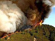
Wildfires
Emergency evacuation
Emergency evacuation is the immediate and rapid movement of people away from the threat or actual occurrence of a hazard. Examples range from the small scale evacuation of a building due to a bomb threat or fire to the large scale evacuation of a district because of a flood, bombardment or...
. Wildfires are less common along the coast because of the cool humid summers, but can occur in autumn when the Marine layer
Marine layer
A marine layer is an air mass which develops over the surface of a large body of water such as the ocean or large lake in the presence of a temperature inversion. The inversion itself is usually initiated by the cooling effect of the water on the surface layer of an otherwise warm air mass...
is less common making it warm and dry.
Glossary
The following are terms used to describe local or regional weather events.- Santa Ana windSanta Ana windThe Santa Ana winds are strong, extremely dry offshore winds that characteristically sweep through Southern California and northern Baja California in late fall and winter. They can range from hot to cold, depending on the prevailing temperatures in the source regions, the Great Basin and upper...
s: Santa Anas are hot, high winds that blow from the eastern mountains and deserts towards coastal Southern CaliforniaSouthern CaliforniaSouthern California is a megaregion, or megapolitan area, in the southern area of the U.S. state of California. Large urban areas include Greater Los Angeles and Greater San Diego. The urban area stretches along the coast from Ventura through the Southland and Inland Empire to San Diego...
, usually in the springSpring (season)Spring is one of the four temperate seasons, the transition period between winter and summer. Spring and "springtime" refer to the season, and broadly to ideas of rebirth, renewal and regrowth. The specific definition of the exact timing of "spring" varies according to local climate, cultures and...
and fallAutumnAutumn is one of the four temperate seasons. Autumn marks the transition from summer into winter usually in September or March when the arrival of night becomes noticeably earlier....
. They are the result of air pressureAtmospheric pressureAtmospheric pressure is the force per unit area exerted into a surface by the weight of air above that surface in the atmosphere of Earth . In most circumstances atmospheric pressure is closely approximated by the hydrostatic pressure caused by the weight of air above the measurement point...
buildup between the Sierra Nevada and the Rocky MountainsRocky MountainsThe Rocky Mountains are a major mountain range in western North America. The Rocky Mountains stretch more than from the northernmost part of British Columbia, in western Canada, to New Mexico, in the southwestern United States...
. This air mass spills out, is pulled by gravity, and circulates clockwise around the high pressure area, bringing winds from the east and northeast; as the air descends in elevation, it heats up and the humidityHumidityHumidity is a term for the amount of water vapor in the air, and can refer to any one of several measurements of humidity. Formally, humid air is not "moist air" but a mixture of water vapor and other constituents of air, and humidity is defined in terms of the water content of this mixture,...
plummets to less than 15%. It is often said that the air is heated and dried as it passes through the nearby deserts, but according to meteorologists this is a popular misconception (it's actually due to adiabatic compression as the air flows from the higher elevations down to sea level); during Santa Ana conditions, it is typically hotter along the coast than in the deserts. As the Santa Ana winds are channeled through the mountain passes they can approach hurricane force. The combination of speed, heat, and dryness turns the chaparralChaparralChaparral is a shrubland or heathland plant community found primarily in the U.S. state of California and in the northern portion of the Baja California peninsula, Mexico...
into explosive fuel for the infamous wildfireWildfireA wildfire is any uncontrolled fire in combustible vegetation that occurs in the countryside or a wilderness area. Other names such as brush fire, bushfire, forest fire, desert fire, grass fire, hill fire, squirrel fire, vegetation fire, veldfire, and wilkjjofire may be used to describe the same...
s the region is known for. - Pineapple ExpressPineapple ExpressPineapple Express is a non-technical term for a meteorological phenomenon characterized by a strong and persistent flow of atmospheric moisture and associated heavy rainfall from the waters adjacent to the Hawaiian Islands and extending to any location along the Pacific coast of North America...
: A complex combination of events, bringing high levels of torrential precipitation to California. The Pineapple Express occurs when the jet streamJet streamJet streams are fast flowing, narrow air currents found in the atmospheres of some planets, including Earth. The main jet streams are located near the tropopause, the transition between the troposphere and the stratosphere . The major jet streams on Earth are westerly winds...
dips across California, and warm, humid air from the mid-Pacific (from the vicinity of HawaiiHawaiiHawaii is the newest of the 50 U.S. states , and is the only U.S. state made up entirely of islands. It is the northernmost island group in Polynesia, occupying most of an archipelago in the central Pacific Ocean, southwest of the continental United States, southeast of Japan, and northeast of...
–hence, the name) is drawn towards California. The resulting combination can cause extraordinarily heavy rains. A January 2005 Pineapple Express dropped nearly 25 inches (63.5 cm) of rain in Santa Barbara County. - Tule fogTule fogTule fog is a thick ground fog that settles in the San Joaquin Valley and Sacramento Valley areas of California's Great Central Valley. Tule fog forms during the late fall and winter after the first significant rainfall. The official time frame for tule fog to form is from November 1 to March 31...
: A thick ground fogFogFog is a collection of water droplets or ice crystals suspended in the air at or near the Earth's surface. While fog is a type of stratus cloud, the term "fog" is typically distinguished from the more generic term "cloud" in that fog is low-lying, and the moisture in the fog is often generated...
that settles in the San Joaquin ValleySan Joaquin ValleyThe San Joaquin Valley is the area of the Central Valley of California that lies south of the Sacramento – San Joaquin River Delta in Stockton...
and Sacramento ValleySacramento ValleyThe Sacramento Valley is the portion of the California Central Valley that lies to the north of the San Joaquin-Sacramento Delta in the U.S. state of California. It encompasses all or parts of ten counties.-Geography:...
areas of the California Central ValleyCalifornia Central ValleyCalifornia's Central Valley is a large, flat valley that dominates the central portion of California. It is home to California's most productive agricultural efforts. The valley stretches approximately from northwest to southeast inland and parallel to the Pacific Ocean coast. Its northern half is...
. Tule fog forms during the mid fallAutumnAutumn is one of the four temperate seasons. Autumn marks the transition from summer into winter usually in September or March when the arrival of night becomes noticeably earlier....
, winter to early spring after the first significant rainfall. This phenomenon is named after the tule grassTuleSchoenoplectus acutus , called tule , common tule, hardstem tule, tule rush, hardstem bulrush, or viscid bulrush, is a giant species of sedge in the plant family Cyperaceae, native to freshwater marshes all over North America...
wetlands of the Central Valley. Tule fog can extend from BakersfieldBakersfield, CaliforniaBakersfield is a city near the southern end of the San Joaquin Valley in Kern County, California. It is roughly equidistant between Fresno and Los Angeles, to the north and south respectively....
to ChicoChico, CaliforniaChico is the most populous city in Butte County, California, United States. The population was 86,187 at the 2010 census, up from 59,954 at the time of the 2000 census...
. Accidents caused by the tule fog are the leading cause of weather-related deaths in California; visibility is usually less than an eighth of a mile (about 600 feet or 183–200 m), but can be less than 10 feet (3 m). - May Gray/June GloomJune GloomJune Gloom is a southern California term for a weather pattern that results in cloudy, overcast skies with cool temperatures during the late spring and early summer. June Gloom in southern California is caused by the marine layer effect common to the West Coast, and is enhanced by the Catalina eddy...
: A characteristic weather pattern of late spring (May and June) in which a combination of inland heat, off-shore cool water, and prevailing wind patterns bring foggy and overcast weather to coastal regions. From Point ConceptionPoint ConceptionPoint Conception is a headland along the Pacific coast of U.S. state of California, located in southwestern Santa Barbara County. It is the point where the Santa Barbara Channel meets the Pacific Ocean, and as the corner between the mostly north-south trending portion of coast to the north and the...
northwards the gloom continues until early autumn. (See also: Catalina eddyCatalina eddyThe "Catalina eddy," also called the "coastal eddy," is a localized weather phenomenon that occurs in the so-called "Bight of California", the mostly convex portion of the Southern California coast running from Point Conception to San Diego...
) - Marine layerMarine layerA marine layer is an air mass which develops over the surface of a large body of water such as the ocean or large lake in the presence of a temperature inversion. The inversion itself is usually initiated by the cooling effect of the water on the surface layer of an otherwise warm air mass...
: The cool, moist layer of air coming in from the ocean which typically includes fog. A standard weather phenomenon along the northern and central California coast from late spring to early fall. - "Earthquake weatherEarthquake weatherEarthquake weather is a type of weather popularly believed to precede earthquakes.-History:From the ancient histories of Herodotus to the modern writings of David Lance Goines, the notion that weather can somehow foreshadow coming seismic activity has been the topic of much discussion and debate...
:" Any unseasonal, uncomfortable weather, typically hot and more humid than usual, and often associated with high and mid-level clouds, is spoken of (usually jokingly) as "earthquake weather."
See also
- List of wettest known tropical cyclones in California