

Cholmondeston
Encyclopedia
Cheshire East
Cheshire East is a unitary authority area with borough status in the ceremonial county of Cheshire, England.The borough was established in April 2009 as part of the 2009 structural changes to local government in England, by virtue of an order under the Local Government and Public Involvement in...
and the ceremonial county of Cheshire
Cheshire
Cheshire is a ceremonial county in North West England. Cheshire's county town is the city of Chester, although its largest town is Warrington. Other major towns include Widnes, Congleton, Crewe, Ellesmere Port, Runcorn, Macclesfield, Winsford, Northwich, and Wilmslow...
, England
England
England is a country that is part of the United Kingdom. It shares land borders with Scotland to the north and Wales to the west; the Irish Sea is to the north west, the Celtic Sea to the south west, with the North Sea to the east and the English Channel to the south separating it from continental...
. The village lies 5 miles to the north west of Nantwich
Nantwich
Nantwich is a market town and civil parish in the Borough of Cheshire East and the ceremonial county of Cheshire, England. The town gives its name to the parliamentary constituency of Crewe and Nantwich...
. Nearby villages include Aston juxta Mondrum
Aston juxta Mondrum
Aston juxta Mondrum is a village and civil parish in the unitary authority of Cheshire East and the ceremonial county of Cheshire, England. It is about four miles north of Nantwich. The civil parish also includes part of Worleston village.-History:...
, Barbridge
Stoke, Crewe and Nantwich
Stoke is a civil parish in the unitary authority of Cheshire East and the ceremonial county of Cheshire, England. The parish is predominantly rural with a total population of around 200. The largest settlement is Barbridge , which lies 3½ miles to the north west of Nantwich. The parish also...
, Calveley
Calveley
Calveley is a village and civil parish in the unitary authority of Cheshire East and the ceremonial county of Cheshire, England. The village lies 5½ miles to the north west of Nantwich. The parish also includes parts of the settlements of Barrets Green and Wardle Bank. Nearby villages include...
and Wettenhall
Wettenhall
Wettenhall is a village and civil parish in the unitary authority of Cheshire East and the ceremonial county of Cheshire, England. The village lies 3½ miles to the south west of Winsford and 6 miles to the north west of Crewe. The parish also includes the settlements of Chapel Green and Woodside...
. The Middlewich branch
Middlewich Branch
The Middlewich Branch of the Shropshire Union Canal is located in Cheshire, in the north west of England, and runs between Middlewich, where it joins the Trent and Mersey Canal, and Barbridge Junction, where it joins the main line of the Shropshire Union Canal...
of the Shropshire Union Canal
Shropshire Union Canal
The Shropshire Union Canal is a navigable canal in England; the Llangollen and Montgomery canals are the modern names of branches of the Shropshire Union system and lie partially in Wales....
and the Crewe
Crewe
Crewe is a railway town within the unitary authority area of Cheshire East and the ceremonial county of Cheshire, England. According to the 2001 census the urban area had a population of 67,683...
–Chester
Chester
Chester is a city in Cheshire, England. Lying on the River Dee, close to the border with Wales, it is home to 77,040 inhabitants, and is the largest and most populous settlement of the wider unitary authority area of Cheshire West and Chester, which had a population of 328,100 according to the...
railway line run through the civil parish. The area is predominantly rural, with a total population of around 150 in 2001.
The name is pronounced "Chumston".
History
A hoard of 26 RomanAncient Rome
Ancient Rome was a thriving civilization that grew on the Italian Peninsula as early as the 8th century BC. Located along the Mediterranean Sea and centered on the city of Rome, it expanded to one of the largest empires in the ancient world....
coins was found in Cholmondeston, suggesting the possibility of Roman settlement in the area. The coins are mainly of the reign of Constantius II
Constantius II
Constantius II , was Roman Emperor from 337 to 361. The second son of Constantine I and Fausta, he ascended to the throne with his brothers Constantine II and Constans upon their father's death....
, dating from after AD 348.
Cholmondeston appears in the Domesday survey
Domesday Book
Domesday Book , now held at The National Archives, Kew, Richmond upon Thames in South West London, is the record of the great survey of much of England and parts of Wales completed in 1086...
of 1086 as Chelmundestone, meaning "Coelmund's Farm". Before the Norman Conquest
Norman conquest of England
The Norman conquest of England began on 28 September 1066 with the invasion of England by William, Duke of Normandy. William became known as William the Conqueror after his victory at the Battle of Hastings on 14 October 1066, defeating King Harold II of England...
, it was held by Wulfeva, described as "a free woman", and afterwards by William Malbank (or Malbedeng), the first Baron of Wich Malbank (Nantwich
Nantwich
Nantwich is a market town and civil parish in the Borough of Cheshire East and the ceremonial county of Cheshire, England. The town gives its name to the parliamentary constituency of Crewe and Nantwich...
). Local historian Frank Latham suggests that it is possible that there was a substantial pre-Conquest village, later deserted. The Domesday survey recorded a population of 4. At this time, Cholmondeston fell within the Forest of Mondrem, the southern half of Delamere Forest
Delamere Forest
Delamere Forest or Delamere Forest Park is a wood in the Cheshire West and Chester area of Cheshire, England, near the town of Frodsham. It includes of mixed deciduous and evergreen woodland, centred at around , making it the largest area of woodland in Cheshire...
. The manor maintained an underforester and also paid frithmote tax, which might have entitled it to certain forest privileges or exempted it from the forest courts. The area of the modern civil parish fell within the ancient parish
Ancient parishes of Cheshire
The Ancient Parishes of Cheshire refers to the group of parishes that existed in Cheshire, roughly within the period of 1200–1800. Initially, the ancient parishes had only an ecclesiastical function, but reforms initiated by King Henry VIII, developed by Queen Elizabeth I and expanded by...
of Acton
Acton, Cheshire (ancient parish)
Acton was an ancient parish in the Nantwich Hundred of Cheshire, England.At one time it included the townships of Acton, Aston juxta Mondrum, Austerson, Baddington, Brindley, Burland, Cholmondeston, Edleston, Faddiley, Henhull, Hurleston, Poole, Stoke, Worleston, most of Coole Pilate, parts of...
in the Nantwich Hundred
Hundreds of Cheshire
The Hundreds of Cheshire, as with other Hundreds in England were the geographic divisions of Cheshire for administrative, military and judicial purposes. They were introduced in Cheshire some time before the Norman conquest...
; it was served by St Mary's Church, Acton
St Mary's Church, Acton
St Mary's Church, Acton is an active Anglican church in Acton, a village to the west of Nantwich, Cheshire, England. It has been designated by English Heritage as a Grade I listed building. A church has been present on this site since before the time of the Domesday Survey. The tower is the...
until 1873.
Early landowners include the Crewe and Wettenhall families. The township was sold by the Earl of Bridgewater
Earl of Bridgewater
-History:The earldom was first created in 1538 for Henry Daubeny, 9th Baron Daubeny. The Daubeney family descended from Elias Daubeny, who in 1295 was summoned by writ to the Model Parliament as Lord Daubeny. The eighth Baron was created Baron Daubeny by letters patent in the Peerage of England in...
to the Werden family in 1686, and by 1800 it had passed to the Drummond family.
In the 18th century, Methodists
Methodism
Methodism is a movement of Protestant Christianity represented by a number of denominations and organizations, claiming a total of approximately seventy million adherents worldwide. The movement traces its roots to John Wesley's evangelistic revival movement within Anglicanism. His younger brother...
were recorded in Cholmondeston, as well as in the adjacent parish of Poole
Poole, Cheshire
Poole is a civil parish in the unitary authority of Cheshire East and the ceremonial county of Cheshire, England, which lies to the north west of Nantwich and to the west of Crewe. The Shropshire Union Canal runs through the parish...
, which John Wesley
John Wesley
John Wesley was a Church of England cleric and Christian theologian. Wesley is largely credited, along with his brother Charles Wesley, as founding the Methodist movement which began when he took to open-air preaching in a similar manner to George Whitefield...
visited four times between 1751 and 1757. Wesley is believed to have stayed at Gates Farm, just inside the Cholmondeston boundary, and he preached in the farm's kitchen. A Wesleyan Methodist Chapel was built in Cholmondeston in 1833. It was replaced by a later red-brick chapel, built from the Twentieth Century Fund, which opened in 1903. The chapel closed in 1973.
Governance
Cholmondeston is administered by Cholmondeston and Wettenhall Parish Council jointly with the adjacent civil parish of WettenhallWettenhall
Wettenhall is a village and civil parish in the unitary authority of Cheshire East and the ceremonial county of Cheshire, England. The village lies 3½ miles to the south west of Winsford and 6 miles to the north west of Crewe. The parish also includes the settlements of Chapel Green and Woodside...
. From 1974 the civil parish was served by Crewe and Nantwich
Crewe and Nantwich
Crewe and Nantwich was, from 1974 to 2009, a local government district with borough status in Cheshire, England. It had a population of 111,007...
Borough Council, which was succeeded on 1 April 2009 by the new unitary authority
Unitary authority
A unitary authority is a type of local authority that has a single tier and is responsible for all local government functions within its area or performs additional functions which elsewhere in the relevant country are usually performed by national government or a higher level of sub-national...
of Cheshire East
Cheshire East
Cheshire East is a unitary authority area with borough status in the ceremonial county of Cheshire, England.The borough was established in April 2009 as part of the 2009 structural changes to local government in England, by virtue of an order under the Local Government and Public Involvement in...
. Cholmondeston falls in the parliamentary constituency of Eddisbury
Eddisbury (UK Parliament constituency)
Eddisbury is a county constituency represented in the House of Commons of the Parliament of the United Kingdom. It elects one Member of Parliament by the first-past-the-post system of election.- Boundaries :...
, and has been represented by Stephen O'Brien since 1999.
Geography, economy and transport
The civil parish has a total area of 1749 acres (707.8 ha). The terrain is predominantly flat, with an average elevation of around 50 metres. A trig point is located at , at an elevation of 55 metres. Crowton Brook runs north–south through the civil parish and Bankside Brook forms part of the northern boundary; there are numerous scattered small meres and ponds. Several small areas of woodland are located within the civil parish. The small village of Cholmondeston lies in the north of the civil parish at the junction between Winsford Road, Minshull Lane and Calveley Green Lane. The area is predominantly rural, with the major land use being agricultural.The Crewe
Crewe
Crewe is a railway town within the unitary authority area of Cheshire East and the ceremonial county of Cheshire, England. According to the 2001 census the urban area had a population of 67,683...
–Chester
Chester
Chester is a city in Cheshire, England. Lying on the River Dee, close to the border with Wales, it is home to 77,040 inhabitants, and is the largest and most populous settlement of the wider unitary authority area of Cheshire West and Chester, which had a population of 328,100 according to the...
railway line runs east–west through the south of the civil parish. It crosses the Middlewich branch
Middlewich Branch
The Middlewich Branch of the Shropshire Union Canal is located in Cheshire, in the north west of England, and runs between Middlewich, where it joins the Trent and Mersey Canal, and Barbridge Junction, where it joins the main line of the Shropshire Union Canal...
of the Shropshire Union Canal
Shropshire Union Canal
The Shropshire Union Canal is a navigable canal in England; the Llangollen and Montgomery canals are the modern names of branches of the Shropshire Union system and lie partially in Wales....
, which also runs broadly east–west, immediately east of Venetian Marina. Two other canal bridges lie in the civil parish. Just to the west of the marina is Cholmondeston Bridge , which carries Winsford Road. Benyon's Bridge is an accommodation (farm) bridge over the canal at . Built in 1827–33 to a design by Thomas Telford
Thomas Telford
Thomas Telford FRS, FRSE was a Scottish civil engineer, architect and stonemason, and a noted road, bridge and canal builder.-Early career:...
, it is listed at grade II. Immediately adjacent to Cholmondeston Bridge is Cholmondeston Lock, the first lock on the Middlewich branch.
The unclassified Winsford Road is the major road of the civil parish; it runs broadly north–south, leading to Wettenhall
Wettenhall
Wettenhall is a village and civil parish in the unitary authority of Cheshire East and the ceremonial county of Cheshire, England. The village lies 3½ miles to the south west of Winsford and 6 miles to the north west of Crewe. The parish also includes the settlements of Chapel Green and Woodside...
and Winsford
Winsford
Winsford is a town and civil parish within the unitary authority of Cheshire West and Chester and the ceremonial county of Cheshire, England. It lies on the River Weaver south of Northwich and west of Middlewich, and grew around the salt mining industry after the river was canalised in the...
to the north, and joining the A51
A51 road
The A51 is a road in England running from Kingsbury in Warwickshire to Chester. The road follows the following route:*Kingsbury*Tamworth*Lichfield*Rugeley *Little Haywood*Great Haywood*Weston*Sandon...
near Nantwich
Nantwich
Nantwich is a market town and civil parish in the Borough of Cheshire East and the ceremonial county of Cheshire, England. The town gives its name to the parliamentary constituency of Crewe and Nantwich...
to the south. In Cholmondeston village, Minshull Lane runs east from Winsford Road to connect with the B5074 at Wades Green near Church Minshull
Church Minshull
Church Minshull is a village and civil parish in the unitary authority of Cheshire East and the ceremonial county of Cheshire, England. The village is located approximately north west of Crewe and to the west of the River Weaver and the Shropshire Union Canal...
, while Calveley Green Lane runs west to connect with Calveley Hall Lane in Calveley
Calveley
Calveley is a village and civil parish in the unitary authority of Cheshire East and the ceremonial county of Cheshire, England. The village lies 5½ miles to the north west of Nantwich. The parish also includes parts of the settlements of Barrets Green and Wardle Bank. Nearby villages include...
. In the south of the civil parish, Stokehall Lane runs west from Winsford Road to connect with the A51 at Barbridge.
The National Cycle Network
National Cycle Network
The National Cycle Network is a network of cycle routes in the United Kingdom.The National Cycle Network was created by the charity Sustrans , and aided by a £42.5 million National Lottery grant. In 2005 it was used for over 230 million trips.Many routes hope to minimise contact with motor...
Regional Route 75 follows Winsford Road. The Weaver Way footpath follows the towpath of the Shropshire Union Canal, connecting with the Crewe and Nantwich Circular Walk
Crewe and Nantwich Circular Walk
The Crewe and Nantwich Circular Walk is a long-distance walkers' path in the Cheshire East area of Cheshire, England. As the name suggests, the walk forms a circuit around the towns of Crewe and Nantwich...
just to the east of the civil parish at Brickyard Bridge.
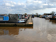
Landmarks
The Venetian Marina on the Shropshire Union CanalShropshire Union Canal
The Shropshire Union Canal is a navigable canal in England; the Llangollen and Montgomery canals are the modern names of branches of the Shropshire Union system and lie partially in Wales....
opened in the early 1970s. As of 2010, it has 250 berths; facilities include workshops, tearooms and a shop.
Demography
In 2006, the total population of the civil parish was estimated as 170. The 2001 census recorded a population of 153, in 53 households. The population has stayed relatively constant since 1801; the historical population figures are 168 (1801), 186 (1851), 162 (1901) and 172 (1951).Education
There are no educational facilities within the civil parish. Cholmondeston falls within the catchment areas of Calveley Primary School in CalveleyCalveley
Calveley is a village and civil parish in the unitary authority of Cheshire East and the ceremonial county of Cheshire, England. The village lies 5½ miles to the north west of Nantwich. The parish also includes parts of the settlements of Barrets Green and Wardle Bank. Nearby villages include...
and Tarporley Community High School
Tarporley Community High School
Tarporley High School and Sixth Form College is a secondary school in the village of Tarporley, Cheshire, England.-Admissions:It has around 1,000 pupils with 64 teachers. It is an over-subscribed school...
in Tarporley
Tarporley
Tarporley is a large village and civil parish in the unitary authority of Cheshire West and Chester and the ceremonial county of Cheshire, England....
.
Sources
- Cheshire Federation of Women's Institutes. The Cheshire Village Book (Countryside Books & CFWI; 1990) (ISBN 1-85306-075-5)
- Husain BMC. Cheshire under the Norman Earls: 1066–1237 (A History of Cheshire, Vol. 4; series editor JJ Bagley) (Cheshire Community Council Publications Trust; 1973)
- Latham FA, ed. Acton (The Local History Group; 1995) (ISBN 0-9522284-1-6)