
Castleshaw Roman fort
Encyclopedia
Castleshaw Roman fort was a fort
in the Roman province
of Britannia
. Although there is no evidence to substantiate the claim, it has been suggested that Castleshaw Roman fort is the site of Rigodunum, a Brigantian
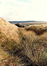
settlement. The remains of the fort are located on Castle Hill on the eastern side of Castleshaw Valley at the foot of Standedge
but overlooking the valley. The hill is on the edge of Castleshaw
in Greater Manchester
. The fort was constructed in c. AD 79, but fell out of use at some time during the 90s. It was replaced by a smaller fortlet, built in c. 105, around which a civilian settlement grew. It may have served as a logistical and administrative centre, although it was abandoned in the 120s.
The site has been the subject of antiquarian
and archaeological
investigation since the 18th century, but the civilian settlement lay undiscovered until the 1990s. The fort, fortlet, and civilian settlement are all protected as a Scheduled Ancient Monument
, recognising its importance as a "nationally important" archaeological site
or historic building, and protecting it against unauthorised change.
 The fort and fortlet at Castleshaw are situated on a step of Grindslow shale
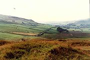
on the eastern side of Castleshaw Valley below Standedge
, part of the Pennine
ridge in northern England
. From the site there are clear views up and down the valley, although it is overshadowed by higher ground on all sides. It is remote and exposed and lies along the Deva Victrix
(Chester
) to Eboracum
(York
) Roman road
. The road crosses the Pennines at Standedge
where the area dips and narrows, creating a traversable pass which would have been guarded by the Castleshaw fort. The nearest forts are Mamucium (Manchester
) 16 miles (25.7 km) to the west and one at Slack 8 miles (12.9 km) to the east, both on the line of the Roman road. There was also possibly a fortlet or signal station at Worlow, between Slack and Castleshaw. The later fortlet is on the same site as the fort .
to Chester
Roman road. Due to the site's protected status as a Scheduled Ancient Monument it has not been possible to excavate the fort, however previous trenches have demonstrated that the fort had two phases
to its construction. The location of the fort's granary, stables, the principia
(headquarters), the praetorium
(commander's tent), and six long narrow buildings which are possibly workshops or storerooms are all known. The fort was small, would probably have been home to around 500 soldiers of an auxiliary
cohort
, and fell out of use during the mid AD 90s. Rather than allow the defences to fall into potentially hostile hands or be used against Rome, the fort was slighted
.
The fort was replaced by a fortlet, also built using turf and timber, in AD 105. Although the fortlet was built on the same site as the fort, it did not use the same foundation trenches. There were two construction phases of the fortlet, the second – dating to c. 120 – featured gates, an oven, a well, a granary, a hypocaust
a workshop, barracks, a commanders house, a courtyard building, and possibly a latrine. The barracks were built to accommodate 48 soldiers and even with administrative staff and officers, the garrison of the fortlet would have numbered less than 100. The first phase was laid out along the same lines as the second phase. The fortlet defences – as with most other fortlets – were designed to withstand attacks from brigands or hold off an enemy until reinforcements from the main army could arrive rather than withstand a determined attack. A civilian settlement or vicus
grew around the fortlet in the early 2nd century. It probably would have been home to those who benefited from trade with the garrison or hangers on of the soldiers. Since it is unlikely that a garrison of under 100 could have supported a vicus, it has been suggested that the fortlet was a commissary fortlet, one which was the administrative and logistical centre of part of the Roman army
. With soldiers regularly arriving to collect pay and orders, a vicus could have been supported. The fortlet fell out of use in the mid 120s. The fort and fortlet of Castleshaw were superseded by the neighbouring forts at Manchester and Slack. The vicus was abandoned around the same time as the fortlet fell out of use.
According to Ptolemy
, there was a polis
called Rigodunum belonging to the Brigantes
near the position of Castleshaw
. Rigodunum means "royal fort". Although it has been suggested that Castleshaw is the location of the Brigantine settlement, there is no evidence to support this. Stamps on two tegulae
, produced at the Roman tilery at Grimescar Wood near Huddersfield
, suggest the fortlet was supplied by the Cohors III Bracaraugustanorum from Pannonia
, maybe even garrisoned by them at one stage. Similar stamps have been found in the forts at Manchester, Slack, and Ebchester
, indicating these forts were linked.
 After being abandoned by the Romans, Castleshaw was rediscovered by antiquarian Thomas Percival
in 1752. The remains were in good enough condition for him to draw a plan and he commented that he was "pleased to find a double Roman camp". He also remarked that the Roman road from Manchester running east to the Pennines was "the finest remain of a Roman road in England that I ever saw". The site has suffered damage from ploughing in the 18th and 19th centuries as it is situated in one of the best draining areas of the valley. In 1897, a local antiquarian and poet, Ammon Wrigley, dug several trenches on the site. He did not record the results of his digging and unrecorded digs continued on and off until 1907. In 1907, the site was bought for the purpose of organised excavation and survey which continued from 1907 to 1908 under the supervision of Francis Bruton who had recently been involved with the excavation of Mamucium. The spoil heaps from the 1907–08 dig were never levelled, leaving a series of misleading modern earthworks on the interior of the site.
Under the supervision of the University of Manchester
, further excavation was undertaken on the site in 1957–61 and 1963–64. Between 1984 and 1988, Greater Manchester Archaeological Unit undertook excavations and restoration of the site. A group led by Professor Barri Jones
– an expert on Roman Britain
– was set up to co-ordinate the work. North West Water
, then the owners of the site, ensured the area would not be used for agriculture. In an attempt to make the site accessible to the public, the outline of the fort and fortlet was marked out in low mounds and an education centre was set up nearby. The area beyond the fort was investigated for the first time in 1995–96; archaeologists were searching for a civilian settlement or vicus
associated with the fort. Surveys revealed a settlement triangular in shape and to the south of the fort. The vicus is listed as a Scheduled Ancient Monument with the fort and fortlet.
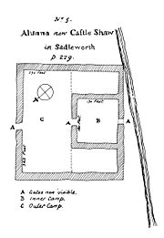
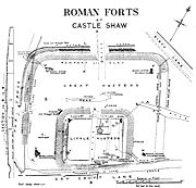 The fort was rectangular in shape and had sides of 115 metres (377.3 ft) and 100 metres (328.1 ft), covering an area of approximately 1.2 hectares (3 acre). The fortlet was built over the south of the fort, making it difficult to discover what lay beneath. It has been possible to however to ascertain that barrack buildings lay on the east side of the fort, a granary on the north, and the pricipia and praetorium to the south west.
The fortlet was rectangular, with sides of 50 metres (164 ft) by 40 metres (131.2 ft), and covered 1950 square metre (0.481855067879788 acre). It was originally thought to be surrounded by a single Punic ditch but investigation revealed there to be two Punic ditches separated by a 2 metres (6.6 ft) wide berm
. The inner ditch was 3.9 metres (12.8 ft) wide and 1.3 metres (4.3 ft) deep while the outer ditch was 2.5 metres (8.2 ft) wide and 0.9 metres (3 ft) deep. A Punic ditch is a defensive v-shaped ditch with one side much steeper than the other; the ditches surrounding the fortlet had an outer face at 27 degrees and the inner face at 69 degrees. The rampart
behind the ditches only survives to 0.5 metres (1.6 ft) at its highest point. It was built from turf on top of sandy clay with a rubble foundation. The fortlet ramparts to the south lay on top of the slighted fort ramparts. Whether corner towers were a feature of the fortlet is unknown, no evidence remains aside from a single posthole
, although only the north and east corners survive in good condition. There were two gateways, one to the north and one to the south.
A civilian settlement is located to the south of the fortlet's defences. The extent of the vicus is uncertain, however, test pits have indicated that it probably extends 12 metres (39.4 ft) west to east and between 25 metres (82 ft) and 35 metres (114.8 ft) to south.
Castra
The Latin word castra, with its singular castrum, was used by the ancient Romans to mean buildings or plots of land reserved to or constructed for use as a military defensive position. The word appears in both Oscan and Umbrian as well as in Latin. It may have descended from Indo-European to Italic...
in the Roman province
Roman province
In Ancient Rome, a province was the basic, and, until the Tetrarchy , largest territorial and administrative unit of the empire's territorial possessions outside of Italy...
of Britannia
Britannia
Britannia is an ancient term for Great Britain, and also a female personification of the island. The name is Latin, and derives from the Greek form Prettanike or Brettaniai, which originally designated a collection of islands with individual names, including Albion or Great Britain. However, by the...
. Although there is no evidence to substantiate the claim, it has been suggested that Castleshaw Roman fort is the site of Rigodunum, a Brigantian
Brigantes
The Brigantes were a Celtic tribe who in pre-Roman times controlled the largest section of what would become Northern England, and a significant part of the Midlands. Their kingdom is sometimes called Brigantia, and it was centred in what was later known as Yorkshire...
settlement. The remains of the fort are located on Castle Hill on the eastern side of Castleshaw Valley at the foot of Standedge
Standedge
Standedge is a moorland escarpment in the Pennine Hills of northern England. Located between Marsden and Diggle, on the edges of the metropolitan counties of West Yorkshire and Greater Manchester respectively, Standedge has been a major moorland crossing point since Roman times and possibly...
but overlooking the valley. The hill is on the edge of Castleshaw
Castleshaw
Castleshaw is a hamlet in the Saddleworth parish of the Metropolitan Borough of Oldham in Greater Manchester, England. It lies amid the Pennines, north of Uppermill, west-southwest of Marsden, and east-northeast of Oldham....
in Greater Manchester
Greater Manchester
Greater Manchester is a metropolitan county in North West England, with a population of 2.6 million. It encompasses one of the largest metropolitan areas in the United Kingdom and comprises ten metropolitan boroughs: Bolton, Bury, Oldham, Rochdale, Stockport, Tameside, Trafford, Wigan, and the...
. The fort was constructed in c. AD 79, but fell out of use at some time during the 90s. It was replaced by a smaller fortlet, built in c. 105, around which a civilian settlement grew. It may have served as a logistical and administrative centre, although it was abandoned in the 120s.
The site has been the subject of antiquarian
Antiquarian
An antiquarian or antiquary is an aficionado or student of antiquities or things of the past. More specifically, the term is used for those who study history with particular attention to ancient objects of art or science, archaeological and historic sites, or historic archives and manuscripts...
and archaeological
Archaeology
Archaeology, or archeology , is the study of human society, primarily through the recovery and analysis of the material culture and environmental data that they have left behind, which includes artifacts, architecture, biofacts and cultural landscapes...
investigation since the 18th century, but the civilian settlement lay undiscovered until the 1990s. The fort, fortlet, and civilian settlement are all protected as a Scheduled Ancient Monument
Scheduled Ancient Monument
In the United Kingdom, a scheduled monument is a 'nationally important' archaeological site or historic building, given protection against unauthorized change. The various pieces of legislation used for legally protecting heritage assets from damage and destruction are grouped under the term...
, recognising its importance as a "nationally important" archaeological site
Archaeological site
An archaeological site is a place in which evidence of past activity is preserved , and which has been, or may be, investigated using the discipline of archaeology and represents a part of the archaeological record.Beyond this, the definition and geographical extent of a 'site' can vary widely,...
or historic building, and protecting it against unauthorised change.
Location
Shale
Shale is a fine-grained, clastic sedimentary rock composed of mud that is a mix of flakes of clay minerals and tiny fragments of other minerals, especially quartz and calcite. The ratio of clay to other minerals is variable. Shale is characterized by breaks along thin laminae or parallel layering...
on the eastern side of Castleshaw Valley below Standedge
Standedge
Standedge is a moorland escarpment in the Pennine Hills of northern England. Located between Marsden and Diggle, on the edges of the metropolitan counties of West Yorkshire and Greater Manchester respectively, Standedge has been a major moorland crossing point since Roman times and possibly...
, part of the Pennine
Pennines
The Pennines are a low-rising mountain range, separating the North West of England from Yorkshire and the North East.Often described as the "backbone of England", they form a more-or-less continuous range stretching from the Peak District in Derbyshire, around the northern and eastern edges of...
ridge in northern England
Northern England
Northern England, also known as the North of England, the North or the North Country, is a cultural region of England. It is not an official government region, but rather an informal amalgamation of counties. The southern extent of the region is roughly the River Trent, while the North is bordered...
. From the site there are clear views up and down the valley, although it is overshadowed by higher ground on all sides. It is remote and exposed and lies along the Deva Victrix
Deva Victrix
Deva Victrix, or simply Deva, was a legionary fortress and town in the Roman province of Britannia. The settlement evolved into Chester, the county town of Cheshire, England...
(Chester
Chester
Chester is a city in Cheshire, England. Lying on the River Dee, close to the border with Wales, it is home to 77,040 inhabitants, and is the largest and most populous settlement of the wider unitary authority area of Cheshire West and Chester, which had a population of 328,100 according to the...
) to Eboracum
Eboracum
Eboracum was a fort and city in Roman Britain. The settlement evolved into York, located in North Yorkshire, England.-Etymology:The first known recorded mention of Eboracum by name is dated circa 95-104 AD and is an address containing the Latin form of the settlement's name, "Eburaci", on a wooden...
(York
York
York is a walled city, situated at the confluence of the Rivers Ouse and Foss in North Yorkshire, England. The city has a rich heritage and has provided the backdrop to major political events throughout much of its two millennia of existence...
) Roman road
Roman road
The Roman roads were a vital part of the development of the Roman state, from about 500 BC through the expansion during the Roman Republic and the Roman Empire. Roman roads enabled the Romans to move armies and trade goods and to communicate. The Roman road system spanned more than 400,000 km...
. The road crosses the Pennines at Standedge
Standedge
Standedge is a moorland escarpment in the Pennine Hills of northern England. Located between Marsden and Diggle, on the edges of the metropolitan counties of West Yorkshire and Greater Manchester respectively, Standedge has been a major moorland crossing point since Roman times and possibly...
where the area dips and narrows, creating a traversable pass which would have been guarded by the Castleshaw fort. The nearest forts are Mamucium (Manchester
Manchester
Manchester is a city and metropolitan borough in Greater Manchester, England. According to the Office for National Statistics, the 2010 mid-year population estimate for Manchester was 498,800. Manchester lies within one of the UK's largest metropolitan areas, the metropolitan county of Greater...
) 16 miles (25.7 km) to the west and one at Slack 8 miles (12.9 km) to the east, both on the line of the Roman road. There was also possibly a fortlet or signal station at Worlow, between Slack and Castleshaw. The later fortlet is on the same site as the fort .
Roman
The fort at Castleshaw, constructed from turf and timber, was built around 79 and guarded the YorkEboracum
Eboracum was a fort and city in Roman Britain. The settlement evolved into York, located in North Yorkshire, England.-Etymology:The first known recorded mention of Eboracum by name is dated circa 95-104 AD and is an address containing the Latin form of the settlement's name, "Eburaci", on a wooden...
to Chester
Deva Victrix
Deva Victrix, or simply Deva, was a legionary fortress and town in the Roman province of Britannia. The settlement evolved into Chester, the county town of Cheshire, England...
Roman road. Due to the site's protected status as a Scheduled Ancient Monument it has not been possible to excavate the fort, however previous trenches have demonstrated that the fort had two phases
Archaeological phase
Archaeological phase and phasing refers to the logical reduction of contexts recorded during excavation to near contemporary archaeological horizons that represent a distinct "phase" of previous land use. These often but not always will be a representation of a former land surface or occupation...
to its construction. The location of the fort's granary, stables, the principia
Principia
Principia could refer to:*Philosophiae Naturalis Principia Mathematica, Isaac Newton's three-volume work containing explanations of his laws of motion and his law of universal gravitation*Principia , a stem-group coralline alga...
(headquarters), the praetorium
Praetorium
- Etemology :The praetorium, also spelled prœtorium or pretorium, was originally used to identify the general’s tent within a Roman Castra, Castellum, or encampment. The word originates from the name of the chief Roman magistrate, known as Praetor...
(commander's tent), and six long narrow buildings which are possibly workshops or storerooms are all known. The fort was small, would probably have been home to around 500 soldiers of an auxiliary
Auxiliaries (Roman military)
Auxiliaries formed the standing non-citizen corps of the Roman army of the Principate , alongside the citizen legions...
cohort
Cohort (military unit)
A cohort was the basic tactical unit of a Roman legion following the reforms of Gaius Marius in 107 BC.-Legionary cohort:...
, and fell out of use during the mid AD 90s. Rather than allow the defences to fall into potentially hostile hands or be used against Rome, the fort was slighted
Slighting
A slighting is the deliberate destruction, partial or complete, of a fortification without opposition. During the English Civil War this was to render it unusable as a fort.-Middle Ages:...
.
The fort was replaced by a fortlet, also built using turf and timber, in AD 105. Although the fortlet was built on the same site as the fort, it did not use the same foundation trenches. There were two construction phases of the fortlet, the second – dating to c. 120 – featured gates, an oven, a well, a granary, a hypocaust
Hypocaust
A hypocaust was an ancient Roman system of underfloor heating, used to heat houses with hot air. The word derives from the Ancient Greek hypo meaning "under" and caust-, meaning "burnt"...
a workshop, barracks, a commanders house, a courtyard building, and possibly a latrine. The barracks were built to accommodate 48 soldiers and even with administrative staff and officers, the garrison of the fortlet would have numbered less than 100. The first phase was laid out along the same lines as the second phase. The fortlet defences – as with most other fortlets – were designed to withstand attacks from brigands or hold off an enemy until reinforcements from the main army could arrive rather than withstand a determined attack. A civilian settlement or vicus
Vicus (Rome)
In ancient Rome, the vicus was a neighborhood. During the Republican era, the four regiones of the city of Rome were subdivided into vici. In the 1st century BC, Augustus reorganized the city for administrative purposes into 14 regions, comprising 265 vici. Each vicus had its own board of...
grew around the fortlet in the early 2nd century. It probably would have been home to those who benefited from trade with the garrison or hangers on of the soldiers. Since it is unlikely that a garrison of under 100 could have supported a vicus, it has been suggested that the fortlet was a commissary fortlet, one which was the administrative and logistical centre of part of the Roman army
Roman army
The Roman army is the generic term for the terrestrial armed forces deployed by the kingdom of Rome , the Roman Republic , the Roman Empire and its successor, the Byzantine empire...
. With soldiers regularly arriving to collect pay and orders, a vicus could have been supported. The fortlet fell out of use in the mid 120s. The fort and fortlet of Castleshaw were superseded by the neighbouring forts at Manchester and Slack. The vicus was abandoned around the same time as the fortlet fell out of use.
According to Ptolemy
Ptolemy
Claudius Ptolemy , was a Roman citizen of Egypt who wrote in Greek. He was a mathematician, astronomer, geographer, astrologer, and poet of a single epigram in the Greek Anthology. He lived in Egypt under Roman rule, and is believed to have been born in the town of Ptolemais Hermiou in the...
, there was a polis
Polis
Polis , plural poleis , literally means city in Greek. It could also mean citizenship and body of citizens. In modern historiography "polis" is normally used to indicate the ancient Greek city-states, like Classical Athens and its contemporaries, so polis is often translated as "city-state."The...
called Rigodunum belonging to the Brigantes
Brigantes
The Brigantes were a Celtic tribe who in pre-Roman times controlled the largest section of what would become Northern England, and a significant part of the Midlands. Their kingdom is sometimes called Brigantia, and it was centred in what was later known as Yorkshire...
near the position of Castleshaw
Castleshaw
Castleshaw is a hamlet in the Saddleworth parish of the Metropolitan Borough of Oldham in Greater Manchester, England. It lies amid the Pennines, north of Uppermill, west-southwest of Marsden, and east-northeast of Oldham....
. Rigodunum means "royal fort". Although it has been suggested that Castleshaw is the location of the Brigantine settlement, there is no evidence to support this. Stamps on two tegulae
Imbrex and tegula
The imbrex and tegula were overlapping roof tiles used in ancient Greek and Roman architecture as a waterproof and durable roof covering. They were made predominantly of fired clay, but also sometimes of marble, bronze or gilt...
, produced at the Roman tilery at Grimescar Wood near Huddersfield
Huddersfield
Huddersfield is a large market town within the Metropolitan Borough of Kirklees, in West Yorkshire, England, situated halfway between Leeds and Manchester. It lies north of London, and south of Bradford, the nearest city....
, suggest the fortlet was supplied by the Cohors III Bracaraugustanorum from Pannonia
Pannonia
Pannonia was an ancient province of the Roman Empire bounded north and east by the Danube, coterminous westward with Noricum and upper Italy, and southward with Dalmatia and upper Moesia....
, maybe even garrisoned by them at one stage. Similar stamps have been found in the forts at Manchester, Slack, and Ebchester
Ebchester
Ebchester is a village in County Durham, in England. It is situated to the north of Consett and to the south east of Whittonstall.The parish church, which is dedicated to St. Ebba is of ambiguous origin, being of partly Norman construction with a foundation, described as being pre-Conquest...
, indicating these forts were linked.
Post-Roman
Thomas Percival
Thomas Percival FRS FRSE FSA was an English physician and author, best known for crafting perhaps the first modern code of medical ethics...
in 1752. The remains were in good enough condition for him to draw a plan and he commented that he was "pleased to find a double Roman camp". He also remarked that the Roman road from Manchester running east to the Pennines was "the finest remain of a Roman road in England that I ever saw". The site has suffered damage from ploughing in the 18th and 19th centuries as it is situated in one of the best draining areas of the valley. In 1897, a local antiquarian and poet, Ammon Wrigley, dug several trenches on the site. He did not record the results of his digging and unrecorded digs continued on and off until 1907. In 1907, the site was bought for the purpose of organised excavation and survey which continued from 1907 to 1908 under the supervision of Francis Bruton who had recently been involved with the excavation of Mamucium. The spoil heaps from the 1907–08 dig were never levelled, leaving a series of misleading modern earthworks on the interior of the site.
Under the supervision of the University of Manchester
University of Manchester
The University of Manchester is a public research university located in Manchester, United Kingdom. It is a "red brick" university and a member of the Russell Group of research-intensive British universities and the N8 Group...
, further excavation was undertaken on the site in 1957–61 and 1963–64. Between 1984 and 1988, Greater Manchester Archaeological Unit undertook excavations and restoration of the site. A group led by Professor Barri Jones
Barri Jones
Geraint Dyfed Barri Jones was a classical scholar and archaeologist.Born in St Helens to Welsh-speaking parents, he attended High Wycombe Royal Grammar School from 1947–1954, and won a Welsh Foundation Scholarship to read classics at Jesus College, Oxford.-Fieldwork and...
– an expert on Roman Britain
Roman Britain
Roman Britain was the part of the island of Great Britain controlled by the Roman Empire from AD 43 until ca. AD 410.The Romans referred to the imperial province as Britannia, which eventually comprised all of the island of Great Britain south of the fluid frontier with Caledonia...
– was set up to co-ordinate the work. North West Water
North West Water
North West Water was a water supply company serving north west England. It was originally the North West Water Authority, one of ten regional authorities created by the Water Act 1973. In 1989 it became North West Water plc, and was privatised...
, then the owners of the site, ensured the area would not be used for agriculture. In an attempt to make the site accessible to the public, the outline of the fort and fortlet was marked out in low mounds and an education centre was set up nearby. The area beyond the fort was investigated for the first time in 1995–96; archaeologists were searching for a civilian settlement or vicus
Vicus (Rome)
In ancient Rome, the vicus was a neighborhood. During the Republican era, the four regiones of the city of Rome were subdivided into vici. In the 1st century BC, Augustus reorganized the city for administrative purposes into 14 regions, comprising 265 vici. Each vicus had its own board of...
associated with the fort. Surveys revealed a settlement triangular in shape and to the south of the fort. The vicus is listed as a Scheduled Ancient Monument with the fort and fortlet.
Layout
The fortlet was rectangular, with sides of 50 metres (164 ft) by 40 metres (131.2 ft), and covered 1950 square metre (0.481855067879788 acre). It was originally thought to be surrounded by a single Punic ditch but investigation revealed there to be two Punic ditches separated by a 2 metres (6.6 ft) wide berm
Berm
A berm is a level space, shelf, or raised barrier separating two areas. Berm originates in the Middle Dutch and German berme and came into usage in English via French.- History :...
. The inner ditch was 3.9 metres (12.8 ft) wide and 1.3 metres (4.3 ft) deep while the outer ditch was 2.5 metres (8.2 ft) wide and 0.9 metres (3 ft) deep. A Punic ditch is a defensive v-shaped ditch with one side much steeper than the other; the ditches surrounding the fortlet had an outer face at 27 degrees and the inner face at 69 degrees. The rampart
Defensive wall
A defensive wall is a fortification used to protect a city or settlement from potential aggressors. In ancient to modern times, they were used to enclose settlements...
behind the ditches only survives to 0.5 metres (1.6 ft) at its highest point. It was built from turf on top of sandy clay with a rubble foundation. The fortlet ramparts to the south lay on top of the slighted fort ramparts. Whether corner towers were a feature of the fortlet is unknown, no evidence remains aside from a single posthole
Posthole
In archaeology a posthole is a cut feature used to hold a surface timber or stone. They are usually much deeper than they are wide although truncation may not make this apparent....
, although only the north and east corners survive in good condition. There were two gateways, one to the north and one to the south.
A civilian settlement is located to the south of the fortlet's defences. The extent of the vicus is uncertain, however, test pits have indicated that it probably extends 12 metres (39.4 ft) west to east and between 25 metres (82 ft) and 35 metres (114.8 ft) to south.