

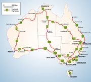
National Highway (Australia)
Encyclopedia

AusLink
AusLink was an Australian Government land transport funding program, established in June 2004 and administered by the Department of Transport and Regional Services. In 2009 it was replaced with the Nation Building Program under the Nation Building Program Act 2009...
National Network) is a system of road
Road
A road is a thoroughfare, route, or way on land between two places, which typically has been paved or otherwise improved to allow travel by some conveyance, including a horse, cart, or motor vehicle. Roads consist of one, or sometimes two, roadways each with one or more lanes and also any...
s connecting all the States and Territories of Australia
Australia
Australia , officially the Commonwealth of Australia, is a country in the Southern Hemisphere comprising the mainland of the Australian continent, the island of Tasmania, and numerous smaller islands in the Indian and Pacific Oceans. It is the world's sixth-largest country by total area...
, and is the major network of highways connecting Australia's largest and most important cities.
The National Highway was established by the National Highway Act 1974 when Gough Whitlam
Gough Whitlam
Edward Gough Whitlam, AC, QC , known as Gough Whitlam , served as the 21st Prime Minister of Australia. Whitlam led the Australian Labor Party to power at the 1972 election and retained government at the 1974 election, before being dismissed by Governor-General Sir John Kerr at the climax of the...
was Prime Minister of Australia
Prime Minister of Australia
The Prime Minister of the Commonwealth of Australia is the highest minister of the Crown, leader of the Cabinet and Head of Her Majesty's Australian Government, holding office on commission from the Governor-General of Australia. The office of Prime Minister is, in practice, the most powerful...
. Before then, while the Federal Government helped to fund major roads, it did not assume direct responsibility for their construction or upkeep. The National Highway was financed entirely by the Federal Government, though State and Territory Governments are responsible for the actual construction and maintenance of the roads that form part of the National Highway.
Under AusLink, established in July 2004, the AusLink National Network has additional links, both road and rail. The Federal Government encourages funding from state, territory and local governments and public-private partnership
Public-private partnership
Public–private partnership describes a government service or private business venture which is funded and operated through a partnership of government and one or more private sector companies...
s to upgrade the network and requires state government funding contributions on parts of the network, especially for new links. For example, the Pacific Highway
Pacific Highway (Australia)
The Pacific Highway is a major transport route along part of the east coast of Australia and is part of Australia's national route 1.It is 960 km long and links Sydney, the capital of New South Wales, to Brisbane, the capital of Queensland, along the coast, via Gosford, Newcastle, Taree, Port...
and the Calder Highway
Calder Highway
Calder Highway is a Highway linking Ravenswood South in Victoria, to Mildura. North of the Victoria/New South Wales border, the highway continues north to Broken Hill, Tibooburra and the New South Wales/Queensland border as the Silver City Highway, under the standard national route shield as far...
are now part of the National Network, but new projects are being funded 50/50 by Federal and State Governments. State contributions (generally 20%) are required on some sections of the old network near major cities.
Various superseded Acts (most recently, the Australian Land Transport Development Act, 1988) specified which roads were eligible to become part of the National Highway. To qualify, a road or a series of connected roads had to be a direct connection between two State or Territory capital cities. The city of Cairns in the far northern part of the State of Queensland
Queensland
Queensland is a state of Australia, occupying the north-eastern section of the mainland continent. It is bordered by the Northern Territory, South Australia and New South Wales to the west, south-west and south respectively. To the east, Queensland is bordered by the Coral Sea and Pacific Ocean...
was also included in former Acts.
The National Highway also includes a small (by comparison) 320 km segment in Tasmania
Tasmania
Tasmania is an Australian island and state. It is south of the continent, separated by Bass Strait. The state includes the island of Tasmania—the 26th largest island in the world—and the surrounding islands. The state has a population of 507,626 , of whom almost half reside in the greater Hobart...
- from the northern port cities of Burnie
Burnie, Tasmania
- Sport :Australian rules football is popular in Burnie. The city's team is the Burnie Dockers Football Club in the Tasmanian State League.Rugby union is also played in Burnie. The local club is the Burnie Rugby Union Club. They are the current Tasmanian Rugby Union Statewide Division Two Premiers...
, Devonport
Devonport, Tasmania
-Sport:The Devonport Football Club is an Australian Rules team competing in the Tasmanian Statewide League. The Devonport Rugby Club is a Rugby Union team competing in the Tasmanian Rugby Union Statewide League...
, to Launceston
Launceston, Tasmania
Launceston is a city in the north of the state of Tasmania, Australia at the junction of the North Esk and South Esk rivers where they become the Tamar River. Launceston is the second largest city in Tasmania after the state capital Hobart...
and ending in the southern capital Hobart
Hobart
Hobart is the state capital and most populous city of the Australian island state of Tasmania. Founded in 1804 as a penal colony,Hobart is Australia's second oldest capital city after Sydney. In 2009, the city had a greater area population of approximately 212,019. A resident of Hobart is known as...
. The Melbourne
Melbourne
Melbourne is the capital and most populous city in the state of Victoria, and the second most populous city in Australia. The Melbourne City Centre is the hub of the greater metropolitan area and the Census statistical division—of which "Melbourne" is the common name. As of June 2009, the greater...
-Devonport
Devonport, Tasmania
-Sport:The Devonport Football Club is an Australian Rules team competing in the Tasmanian Statewide League. The Devonport Rugby Club is a Rugby Union team competing in the Tasmanian Rugby Union Statewide League...
ferry route is sometimes described colloquially as the 'sea highway', providing a link from Tasmania to the rest of the country by road.
Some of the well-known highways that are part of the National Highway include the Hume Highway
Hume Highway
The Hume Highway/Hume Freeway is one of Australia's major inter-city highways, running for 880 km between Sydney and Melbourne. It is part of the Auslink National Network and is a vital link for road freight to transport goods to and from the two cities as well as serving Albury-Wodonga and...
, the Bruce Highway
Bruce Highway
The Bruce Highway is a major highway in Queensland, Australia. Commencing in the state capital, Brisbane, it passes through areas close to the eastern coast to Cairns in Far North Queensland. The route is a part of the Australian National Highway and also part of Highway 1...
, the Eyre Highway
Eyre Highway
The Eyre Highway is a highway linking Western Australia and South Australia via the Nullarbor Plain. Signed as National Highway 1/A1, it forms part of Highway 1 and the Australian National Highway network linking Perth and Adelaide. It was named after explorer Edward John Eyre, who was the first to...
and the New England Highway
New England Highway
The New England Highway is a highway in Australia running from Hexham near Newcastle at its southern end to Yarraman near Toowoomba at its northern end. At its southern end it connects to the Pacific Highway and at its northern end it connects to the D'Aguilar Highway. It traverses the Hunter...
.
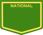
National Highways are denoted by a route marker in the shape of the highway route number shields found around Australia. The word "NATIONAL" is printed in the upper portion of the shield above the highway's number. The shield, text and number are coloured yellow while the background is dark green - Australia's national colours.
National Highway numbering originates from the earlier National Route network. Many of the routes that are now National Highways with the signature green and gold shields, continue beyond the official National Highway as the black and white shielded National Routes. Certain stretches of the National Highways have "A" and "M" tag on their shields; particularly those in Victoria and South Australia. They have completely revised their route numbering, basing it on the British M, A, B, C classifications. These states have retained the original National Highway numbering and shield decal, having added the appropriate M and A classification.
List of roads on the AusLink National Network
- SydneySydneySydney is the most populous city in Australia and the state capital of New South Wales. Sydney is located on Australia's south-east coast of the Tasman Sea. As of June 2010, the greater metropolitan area had an approximate population of 4.6 million people...
to MelbourneMelbourneMelbourne is the capital and most populous city in the state of Victoria, and the second most populous city in Australia. The Melbourne City Centre is the hub of the greater metropolitan area and the Census statistical division—of which "Melbourne" is the common name. As of June 2009, the greater...
- Hume HighwayHume HighwayThe Hume Highway/Hume Freeway is one of Australia's major inter-city highways, running for 880 km between Sydney and Melbourne. It is part of the Auslink National Network and is a vital link for road freight to transport goods to and from the two cities as well as serving Albury-Wodonga and...
and Hume Freeway - Sydney to BrisbaneBrisbaneBrisbane is the capital and most populous city in the Australian state of Queensland and the third most populous city in Australia. Brisbane's metropolitan area has a population of over 2 million, and the South East Queensland urban conurbation, centred around Brisbane, encompasses a population of...
- the Sydney-Newcastle FreewaySydney-Newcastle FreewayThe Sydney-Newcastle Freeway is a stretch of motorway linking Sydney to the Central Coast, Newcastle and Hunter regions of New South Wales. It is part of the AusLink road corridor between Sydney and Brisbane, carrying the route designation....
, New EnglandNew England HighwayThe New England Highway is a highway in Australia running from Hexham near Newcastle at its southern end to Yarraman near Toowoomba at its northern end. At its southern end it connects to the Pacific Highway and at its northern end it connects to the D'Aguilar Highway. It traverses the Hunter...
and Cunningham HighwayCunningham HighwayThe Cunningham Highway is a National Highway in Queensland, Australia. It is named after the explorer and botanist Allan Cunningham who followed a route close to where the modern day highway runs.-Route:...
s route and the Pacific HighwayPacific Highway (Australia)The Pacific Highway is a major transport route along part of the east coast of Australia and is part of Australia's national route 1.It is 960 km long and links Sydney, the capital of New South Wales, to Brisbane, the capital of Queensland, along the coast, via Gosford, Newcastle, Taree, Port...
route - Brisbane to Cairns - Bruce HighwayBruce HighwayThe Bruce Highway is a major highway in Queensland, Australia. Commencing in the state capital, Brisbane, it passes through areas close to the eastern coast to Cairns in Far North Queensland. The route is a part of the Australian National Highway and also part of Highway 1...
- Brisbane to DarwinDarwin, Northern TerritoryDarwin is the capital city of the Northern Territory, Australia. Situated on the Timor Sea, Darwin has a population of 127,500, making it by far the largest and most populated city in the sparsely populated Northern Territory, but the least populous of all Australia's capital cities...
- WarregoWarrego HighwayThe Warrego Highway is located in southern Queensland, Australia. It connects coastal centres to the south western areas of the state, and is approximately 750 km in length. It takes its name from the Warrego River, which is the endpoint of the highway...
, LandsboroughLandsborough HighwayLandsborough Highway is a western Queensland highway running in the northwest-southeast direction from Morven to Cloncurry. The Landsborough Highway runs through vast tracts of land that was once occupied by William Landsborough, an Australian explorer of the 19th century...
, BarklyBarkly HighwayThe Barkly Highway is a national highway of both Queensland and the Northern Territory.-Description:It runs westward from Cloncurry and the junctions of the Flinders and Landsborough highways to the junction with the Stuart Highway north of Tennant Creek...
and Stuart HighwayStuart HighwayThe Stuart Highway is one of Australia's major highways. It is a segment of Australia's Highway 1 extending from Darwin, Northern Territory, in the north, via Tennant Creek and Alice Springs, to Port Augusta, South Australia, in the south—a distance of...
s - Brisbane to Melbourne - Warrego, GoreGore HighwayGore Highway is a highway in Queensland running from Goondiwindi to Toowoomba. Together with Goulburn Valley Highway and Newell Highway, it is a part of the National Highway's Melbourne-Brisbane link. It is signed as ....
, NewellNewell HighwayThe Newell Highway is the longest highway in New South Wales, Australia. It runs parallel to the eastern coast about 400 kilometres inland, and is the main inland direct road link from Victoria to Queensland, bypassing the more congested coastal areas of New South Wales...
and Goulburn Valley HighwayGoulburn Valley HighwayThe Goulburn Valley Highway / is a highway located in Victoria, Australia. The section north beyond the Hume Freeway is part of the Melbourne to Brisbane National Highway and is the main link between these two cities as well as a major link between Victoria and inland New South Wales...
s and Hume Freeway - Melbourne to AdelaideAdelaideAdelaide is the capital city of South Australia and the fifth-largest city in Australia. Adelaide has an estimated population of more than 1.2 million...
- Western FreewayWestern FreewayWestern Freeway or Western Expressway may mean:In roads:*Western Freeway , Virginia, United States*Western Freeway , Australia*Western Freeway, Brisbane, Australia*Western Freeway , India...
, Western HighwayWestern Highway, VictoriaThe Western Highway is part of the principal route linking the Australian cities of Melbourne and Adelaide with a length of approximately 314 kilometres. It is a part of the National Highway network and designated as National Highway A8...
, Dukes HighwayDukes HighwayThe Dukes Highway is an important 189 kilometre highway corridor in South Australia which links the Australian cities of Adelaide and Melbourne. It is part of the National Highway system spanning Australia, and is signed as National Highway A8....
, South Eastern FreewaySouth Eastern FreewayThe South Eastern Freeway is a 66 kilometre four-lane divided carriageway road in South Australia linking the Adelaide-Crafers Highway to the Princes Highway at the Swanport Bridge, a one kilometre long bridge over the River Murray, near Murray Bridge...
and Adelaide-Crafers HighwayAdelaide-Crafers HighwayThe Adelaide-Crafers Highway is a 10 kilometre controlled-access highway linking Adelaide city centre to Crafers in the Adelaide hills, and continuing from Crafers as the South Eastern Freeway. The highway is ten kilometres long, including 500 metre long twin-tube tunnels , the first of their kind... - Adelaide to Darwin - Port Wakefield RoadPort Wakefield RoadPort Wakefield Road is an important Australian highway. It connects Adelaide, the South Australian capital, to the Yorke Peninsula, Port Augusta, northern and western South Australia, the Northern Territory and Western Australia. It is designated National Highway A1 and a part of the National Highway...
and Stuart HighwayStuart HighwayThe Stuart Highway is one of Australia's major highways. It is a segment of Australia's Highway 1 extending from Darwin, Northern Territory, in the north, via Tennant Creek and Alice Springs, to Port Augusta, South Australia, in the south—a distance of... - Adelaide to Sydney - SturtSturt HighwayThe Sturt Highway is an Australian highway in New South Wales, Victoria, and South Australia. It is part of the Auslink National network and is part of the main highway route between Sydney and Adelaide.-Route:...
and Hume Highways - Adelaide to PerthPerth, Western AustraliaPerth is the capital and largest city of the Australian state of Western Australia and the fourth most populous city in Australia. The Perth metropolitan area has an estimated population of almost 1,700,000....
- Port Wakefield RoadPort Wakefield RoadPort Wakefield Road is an important Australian highway. It connects Adelaide, the South Australian capital, to the Yorke Peninsula, Port Augusta, northern and western South Australia, the Northern Territory and Western Australia. It is designated National Highway A1 and a part of the National Highway...
, EyreEyre HighwayThe Eyre Highway is a highway linking Western Australia and South Australia via the Nullarbor Plain. Signed as National Highway 1/A1, it forms part of Highway 1 and the Australian National Highway network linking Perth and Adelaide. It was named after explorer Edward John Eyre, who was the first to...
, Coolgardie-EsperanceCoolgardie-Esperance HighwayThe Coolgardie–Esperance Highway is a 368 km Western Australian highway between Coolgardie and Esperance. It runs in a north-south direction linking the WA's Eastern Goldfields to the coast....
and Great Eastern HighwayGreat Eastern HighwayThe Great Eastern Highway is a major road between the Western Australian cities of Perth and Kalgoorlie. It is a key route for vehicles accessing the eastern wheatbelt and the eastern goldfields...
s - Perth to Darwin - Great NorthernGreat Northern HighwayThe Great Northern Highway is a generally north-south Western Australian highway which links the state's capital Perth with its most northern port, Wyndham. It is in length, with being National Highway...
, VictoriaVictoria HighwayThe Victoria Highway is a 524 kilometre highway linking the Great Northern Highway in Western Australia with the Stuart Highway in the Northern Territory. It is a part of the Perth - Darwin National Highway link. It is signed as National Highway 1 and is also a part of the Highway 1 network. It is...
and Stuart HighwayStuart HighwayThe Stuart Highway is one of Australia's major highways. It is a segment of Australia's Highway 1 extending from Darwin, Northern Territory, in the north, via Tennant Creek and Alice Springs, to Port Augusta, South Australia, in the south—a distance of...
s - Sydney to CanberraCanberraCanberra is the capital city of Australia. With a population of over 345,000, it is Australia's largest inland city and the eighth-largest city overall. The city is located at the northern end of the Australian Capital Territory , south-west of Sydney, and north-east of Melbourne...
- Hume and Federal HighwayFederal Highway (Australia)The Federal Highway is a short highway in New South Wales and the Australian Capital Territory in Australia. It is a part of the Sydney-Canberra National Highway link....
s - Melbourne to Canberra - Hume Freeway, Hume and Barton HighwayBarton HighwayThe Barton Highway is a short highway in New South Wales and the Australian Capital Territory, Australia.The Barton Highway connects Canberra to the Hume Highway at Yass, and it is part of the route from Melbourne to Canberra....
s - HobartHobartHobart is the state capital and most populous city of the Australian island state of Tasmania. Founded in 1804 as a penal colony,Hobart is Australia's second oldest capital city after Sydney. In 2009, the city had a greater area population of approximately 212,019. A resident of Hobart is known as...
to BurnieBurnie, Tasmania- Sport :Australian rules football is popular in Burnie. The city's team is the Burnie Dockers Football Club in the Tasmanian State League.Rugby union is also played in Burnie. The local club is the Burnie Rugby Union Club. They are the current Tasmanian Rugby Union Statewide Division Two Premiers...
including the link from LauncestonLaunceston, TasmaniaLaunceston is a city in the north of the state of Tasmania, Australia at the junction of the North Esk and South Esk rivers where they become the Tamar River. Launceston is the second largest city in Tasmania after the state capital Hobart...
to Bell BayBell Bay, TasmaniaBell Bay is an industrial centre and port located on the eastern shore of the Tamar River, in northern Tasmania, Australia. It lies just south of George Town.- Industry :It hosts an aluminium smelter and a power station.- Transport :...
- BrookerBrooker HighwayThe Brooker Highway is a highway in the State of Tasmania, Australia. Also known as the Northern Outlet, the highway is the major arterial route through Hobart's northern suburbs and is Hobart's major road connection to the cities and towns of Northern Tasmania...
, Midlands and the Bass Highway - Townsville to Mount Isa - Flinders HighwayFlinders Highway, QueenslandFlinders Highway is a highway that crosses Queensland from east to west, from Townsville on the Pacific coast to Cloncurry . Flinders Highway and passes a number of small outback towns. Typical outback landscape predominates towards the inland...
- Melbourne to SaleSale, VictoriaSale is a city in the Gippsland region of the Australian state of Victoria. It is the seat of the Shire of Wellington as well as the Roman Catholic Diocese of Sale and the Anglican Diocese of Gippsland. It has a population of around 13,336, and is expected to reach a population of 14,000 soon...
- Princes HighwayPrinces HighwayThe Princes Highway extends from Sydney to Port Augusta via the coast through the states of New South Wales, Victoria and South Australia, a distance of 1941 km or 1898 km via the former alignments of the highway .... - Perth to BunburyBunbury, Western AustraliaThe port city of Bunbury is the third largest city in Western Australia after the State Capital Perth and Mandurah. It is situated south of Perth's central business district...
- South Western HighwaySouth Western HighwaySouth Western Highway is a highway in the South West region of Western Australia connecting Perth's southeast with Walpole. It is a part of the National Highway 1 network for most of its length... - Melbourne to Mildura - Calder HighwayCalder HighwayCalder Highway is a Highway linking Ravenswood South in Victoria, to Mildura. North of the Victoria/New South Wales border, the highway continues north to Broken Hill, Tibooburra and the New South Wales/Queensland border as the Silver City Highway, under the standard national route shield as far...
- Sydney to Dubbo - Great WesternGreat Western HighwayThe Great Western Highway is a highway in New South Wales, Australia. It runs 210 km from Sydney to Bathurst.Starting as Broadway at the intersection of City Road near the fringe of the Sydney CBD, and becoming Parramatta Road to Parramatta itself, the Great Western Highway heads due west from...
and Mitchell HighwayMitchell HighwayThe Mitchell Highway is a major rural highway in Australia, travelling through central and northern New South Wales and south central Queensland. The highway starts from its northern end in Queensland with the Landsborough Highway near Augathella and continues south to Charleville and Cunnamulla...
s - Sydney to Wollongong - Southern FreewaySouthern FreewaySouthern Freeway is a freeway linking Sydney to Wollongong. It currently is designated as part of National Route 1, however was formerly signposted as F6 under a former route numbering system, and is commonly known by this latter name...
and Princes Highway - Melbourne to Geelong - Princes Highway
- some urban links in Sydney, Melbourne, Brisbane, Perth and Adelaide, connecting the long distance links to each other and to ports and airports.