

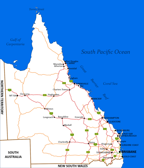
List of highways in Queensland
Encyclopedia

Outback
The Outback is the vast, remote, arid area of Australia, term colloquially can refer to any lands outside the main urban areas. The term "the outback" is generally used to refer to locations that are comparatively more remote than those areas named "the bush".-Overview:The outback is home to a...
is well served as it is relatively populated.
Road quality varies from 8-laned Pacific Motorway
Pacific Motorway
The Pacific Motorway is a 100 km long motorway in Australia between Brisbane, Queensland, and the New South Wales-Queensland border at Tweed Heads. The motorway starts at Coronation Drive at Milton in Brisbane, and from 2008 links the Tweed Heads bypass in New South Wales...
linking Brisbane
Brisbane
Brisbane is the capital and most populous city in the Australian state of Queensland and the third most populous city in Australia. Brisbane's metropolitan area has a population of over 2 million, and the South East Queensland urban conurbation, centred around Brisbane, encompasses a population of...
- Gold Coast
Gold Coast, Queensland
Gold Coast is a coastal city of Australia located in South East Queensland, 94km south of the state capital Brisbane. With a population approximately 540,000 in 2010, it is the second most populous city in the state, the sixth most populous city in the country, and also the most populous...
to earth packed outback tracks, reflecting the great diversity of its terrain and climatic conditions. The route markings are also unique in the sense that Queensland uses all available scheme, from old-style National Route scheme and the blue-shielded State Route scheme to the lateset Alphanumeric Numbering scheme and the Metroads metropolitan route numbering scheme. This is the list of highways in Queensland
Queensland
Queensland is a state of Australia, occupying the north-eastern section of the mainland continent. It is bordered by the Northern Territory, South Australia and New South Wales to the west, south-west and south respectively. To the east, Queensland is bordered by the Coral Sea and Pacific Ocean...
. It has 33 entries.
National Highways
- Bruce HighwayBruce HighwayThe Bruce Highway is a major highway in Queensland, Australia. Commencing in the state capital, Brisbane, it passes through areas close to the eastern coast to Cairns in Far North Queensland. The route is a part of the Australian National Highway and also part of Highway 1...
- Bruce HighwayBruce HighwayThe Bruce Highway is a major highway in Queensland, Australia. Commencing in the state capital, Brisbane, it passes through areas close to the eastern coast to Cairns in Far North Queensland. The route is a part of the Australian National Highway and also part of Highway 1...

- Barkly HighwayBarkly HighwayThe Barkly Highway is a national highway of both Queensland and the Northern Territory.-Description:It runs westward from Cloncurry and the junctions of the Flinders and Landsborough highways to the junction with the Stuart Highway north of Tennant Creek...
- Landsborough HighwayLandsborough HighwayLandsborough Highway is a western Queensland highway running in the northwest-southeast direction from Morven to Cloncurry. The Landsborough Highway runs through vast tracts of land that was once occupied by William Landsborough, an Australian explorer of the 19th century...
- Warrego HighwayWarrego HighwayThe Warrego Highway is located in southern Queensland, Australia. It connects coastal centres to the south western areas of the state, and is approximately 750 km in length. It takes its name from the Warrego River, which is the endpoint of the highway...
- Barkly Highway

- Cunningham HighwayCunningham HighwayThe Cunningham Highway is a National Highway in Queensland, Australia. It is named after the explorer and botanist Allan Cunningham who followed a route close to where the modern day highway runs.-Route:...
- New England HighwayNew England HighwayThe New England Highway is a highway in Australia running from Hexham near Newcastle at its southern end to Yarraman near Toowoomba at its northern end. At its southern end it connects to the Pacific Highway and at its northern end it connects to the D'Aguilar Highway. It traverses the Hunter...
- Cunningham Highway

- Gore HighwayGore HighwayGore Highway is a highway in Queensland running from Goondiwindi to Toowoomba. Together with Goulburn Valley Highway and Newell Highway, it is a part of the National Highway's Melbourne-Brisbane link. It is signed as ....
- Leichhardt HighwayLeichhardt HighwayThe Leichhardt Highway is a major transport route in Queensland, Australia. It is a continuation northward from Goondiwindi of the Newell Highway....
- Gore Highway
State Highways
-
Gateway MotorwayThe Gateway Motorway is a major motorway in Brisbane, Queensland, Australia. The Gateway Bridge is owned and operated by Queensland Motorways....
- Pacific MotorwayPacific MotorwayThe Pacific Motorway is a 100 km long motorway in Australia between Brisbane, Queensland, and the New South Wales-Queensland border at Tweed Heads. The motorway starts at Coronation Drive at Milton in Brisbane, and from 2008 links the Tweed Heads bypass in New South Wales...
- Captain Cook HighwayCaptain Cook HighwayCaptain Cook Highway is a short Queensland highway that starts in Cairns and ends in Mossman, where it joins Mossman-Daintree Road, which continues to Daintree.Captain Cook Highway is used by many tourists to travel to Port Douglas north of Cairns...
- Gulf Developmental RoadGulf Developmental RoadThe Gulf Developmental Road links the Cairns and Normanton regions in northern Queensland, Australia. It is the only sealed road linking these two regions....
- Kennedy HighwayKennedy HighwayThe Kennedy Highway is a highway in northern Queensland, Australia. It runs for approximately 250 km from Smithfield, on the northern outskirts of Cairns, to the Gulf Development Road in the vicinity of Forty Mile Scrub and Undara Volcanic national parks, about 40 kilometres south of Mount...
- Savannah WaySavannah WaySavannah Way is a route of highways and major roads across northern Australia, linking Cairns in Queensland with Broome in Western Australia. Promoted as a self-drive tourist route, in travels from Cairns to Normanton, Borroloola, Katherine, Kununurra, Fitzroy Crossing, Derby and Broome.Much of...
 Gold Coast Highway
Gold Coast Highway
The Gold Coast Highway in Queensland, Australia links the coastal suburbs of the Gold Coast. 33 km in length, the highway passes through popular tourist resorts such as Southport, Surfers Paradise, Burleigh Heads and Currumbin...
 Pacific Motorway
Pacific Motorway
The Pacific Motorway is a 100 km long motorway in Australia between Brisbane, Queensland, and the New South Wales-Queensland border at Tweed Heads. The motorway starts at Coronation Drive at Milton in Brisbane, and from 2008 links the Tweed Heads bypass in New South Wales...

- Burnett HighwayBurnett HighwayThe Burnett Highway is an inland rural highway located in Queensland, Australia. The highway runs generally north - south, from its junction with the Bruce Highway, just south of Rockhampton, to Nanango. Length is approximately 550 kilometres...
- D'Aguilar HighwayD'Aguilar HighwayThe D'Aguilar Highway is a two-lane highway linking the Bruce Highway near Caboolture with Kingaroy in the state of Queensland, Australia. Major towns along the route include Woodford, Kilcoy, Yarraman, Nanango and Kingaroy...
- New England HighwayNew England HighwayThe New England Highway is a highway in Australia running from Hexham near Newcastle at its southern end to Yarraman near Toowoomba at its northern end. At its southern end it connects to the Pacific Highway and at its northern end it connects to the D'Aguilar Highway. It traverses the Hunter...
 Isis Highway
Isis Highway
The Isis Highway is a state highway in southern Queensland, Australia. The highway is relatively short, and runs for 142 kilometres in a north-east direction from its junction with the Burnett Highway at Ban Ban Springs to Bundaberg...
 Gateway Motorway
Gateway Motorway
The Gateway Motorway is a major motorway in Brisbane, Queensland, Australia. The Gateway Bridge is owned and operated by Queensland Motorways....
 Capricorn Highway
Capricorn Highway
The Capricorn Highway is located in Central Queensland, Australia, and links the city of Rockhampton with western Queensland. The highway is approximately 560 kilometres long, and joins the Landsborough Highway at Barcaldine...
 Leichhardt Highway
Leichhardt Highway
The Leichhardt Highway is a major transport route in Queensland, Australia. It is a continuation northward from Goondiwindi of the Newell Highway....
 Flinders Highway
Flinders Highway, Queensland
Flinders Highway is a highway that crosses Queensland from east to west, from Townsville on the Pacific coast to Cloncurry . Flinders Highway and passes a number of small outback towns. Typical outback landscape predominates towards the inland...

- Carnarvon HighwayCarnarvon HighwayThe Carnarvon Highway is a state highway of Queensland, linking Moree south of the NSW/QLD border, via the town of St George, eventually to the township of Rolleston. North of Roma it is known as the Carnarvon Developmental Road. National Route 46 runs from Moree to St George...
- Dawson HighwayDawson HighwayThe Dawson Highway is a state highway in Queensland, Australia. It runs for approximately 400 km between Gladstone and Springsure where it terminates...
- Gregory HighwayGregory HighwayThe Gregory Highway is a state highway in Queensland that serves the major coal-mining centres of Central Queensland. The highway was named after Augustus Gregory, an early explorer....
Mount Lindesay Highway
The Mount Lindesay Highway is a highway in Queensland which has been given the national route number 13. It runs from Brisbane, where it leaves Ipswich Road in the suburb of Moorooka , to the New South Wales border where it becomes the Summerland Way heading south to Kyogle.The highway used to...
- Brisbane Valley HighwayBrisbane Valley HighwayThe Brisbane Valley Highway is a state highway in Queensland. It leaves the Warrego Highway near Ipswich and travels in a northwesterly direction, following the Brisbane River until it reaches the D'Aguilar Highway about south-east of Moore, where it ends...
- D'Aguilar HighwayD'Aguilar HighwayThe D'Aguilar Highway is a two-lane highway linking the Bruce Highway near Caboolture with Kingaroy in the state of Queensland, Australia. Major towns along the route include Woodford, Kilcoy, Yarraman, Nanango and Kingaroy...
 Palmerston Highway
Palmerston Highway
The Palmerston Highway , serves as a link between the southern limit of the Atherton Tablelands and the Far North Queensland coastal strip, in Australia. Starting just north of Innisfail, from the Bruce Highway it winds through the Wooroonooran National Park, past the township of Millaa Millaa and...
 Burke Developmental Road
Burke Developmental Road
The Burke Developmental Road is a Queensland developmental road. It links Cloncurry and Normanton in a south–north direction, then continues to the east 30 km north from Normanton, till Dimbulah, where it becomes the Mareeba Dimbulah Road....
Cunningham Highway
The Cunningham Highway is a National Highway in Queensland, Australia. It is named after the explorer and botanist Allan Cunningham who followed a route close to where the modern day highway runs.-Route:...
 Captain Cook Highway
Captain Cook Highway
Captain Cook Highway is a short Queensland highway that starts in Cairns and ends in Mossman, where it joins Mossman-Daintree Road, which continues to Daintree.Captain Cook Highway is used by many tourists to travel to Port Douglas north of Cairns...
Carnarvon Highway
The Carnarvon Highway is a state highway of Queensland, linking Moree south of the NSW/QLD border, via the town of St George, eventually to the township of Rolleston. North of Roma it is known as the Carnarvon Developmental Road. National Route 46 runs from Moree to St George...

- Balonne HighwayBalonne HighwayThe Balonne Highway, a state highway of Queensland, is the continuation westward of the Moonie Highway from the town of St George to its termination at Cunnamulla. It follows the Balonne River for the most part and is named after it. There are no settlements of any real size between St George and...
- Bunya HighwayBunya HighwayThe Bunya Highway is a 173 kilometre state highway of Queensland, Australia. It is a relatively short road, running approximately 170 kilometres in a south-westerly direction from Goomeri to Dalby. The highway connects the Warrego and Burnett Highways....
- Moonie HighwayMoonie HighwayThe Moonie Highway is a state highway of Queensland, Australia. It leaves the Warrego Highway at Dalby and runs for over 250 km until it reaches St George. From there, it continues as the Balonne Highway...
- Wide Bay HighwayWide Bay HighwayThe Wide Bay Highway is a state highway of Queensland, Australia. It is a rather short road, running approximately 45 kilometres in an east-west direction linking Goomeri to Gympie...
 Isis Highway
Isis Highway
The Isis Highway is a state highway in southern Queensland, Australia. The highway is relatively short, and runs for 142 kilometres in a north-east direction from its junction with the Burnett Highway at Ban Ban Springs to Bundaberg...
 Castlereagh Highway
Castlereagh Highway
The Castlereagh Highway is a state highway in New South Wales, Australia, also extending some kilometres into Queensland. It has been given the route number 55. The highway was recently extended past Gilgandra to include state route 86...
 Dawson Highway
Dawson Highway
The Dawson Highway is a state highway in Queensland, Australia. It runs for approximately 400 km between Gladstone and Springsure where it terminates...
 Kennedy Highway
Kennedy Highway
The Kennedy Highway is a highway in northern Queensland, Australia. It runs for approximately 250 km from Smithfield, on the northern outskirts of Cairns, to the Gulf Development Road in the vicinity of Forty Mile Scrub and Undara Volcanic national parks, about 40 kilometres south of Mount...
 Gregory Highway
Gregory Highway
The Gregory Highway is a state highway in Queensland that serves the major coal-mining centres of Central Queensland. The highway was named after Augustus Gregory, an early explorer....
 Peak Downs Highway
Peak Downs Highway
The Peak Downs Highway links the towns of Mackay and Clermont in the Australian state of Queensland. It represents the main link between Queensland's Whitsunday Coast and the Central West region of the state. The highway runs for a total length of 273 km, before becoming the Gregory Highway ...
 Mitchell Highway
Mitchell Highway
The Mitchell Highway is a major rural highway in Australia, travelling through central and northern New South Wales and south central Queensland. The highway starts from its northern end in Queensland with the Landsborough Highway near Augathella and continues south to Charleville and Cunnamulla...
 Mulligan Highway
Mulligan Highway
The Mulligan Highway is a new state highway in Queensland, Australia. It runs for approximately 270 km between Mareeba and Cooktown, on the east coast of the Cape York Peninsula where it terminates....

- Barwon HighwayBarwon HighwayThe Barwon Highway is one of the more obscure state highways of Queensland. It joins the Leichhardt Highway a few kilometres north of Goondiwindi and travels west for a couple of hundred kilometres until it reaches the Carnarvon Highway at Nindigully, 44 kilometres south of St George, and then...
- Brisbane Valley HighwayBrisbane Valley HighwayThe Brisbane Valley Highway is a state highway in Queensland. It leaves the Warrego Highway near Ipswich and travels in a northwesterly direction, following the Brisbane River until it reaches the D'Aguilar Highway about south-east of Moore, where it ends...
- D'Aguilar HighwayD'Aguilar HighwayThe D'Aguilar Highway is a two-lane highway linking the Bruce Highway near Caboolture with Kingaroy in the state of Queensland, Australia. Major towns along the route include Woodford, Kilcoy, Yarraman, Nanango and Kingaroy...
- Esk-Hampton RoadEsk-Hampton RoadThe Esk-Hampton Road is a state highway in Queensland. It leaves the Brisbane Valley Highway at Esk and travels in a westerly direction for about until it reaches the New England Highway at Hampton, where it ends...
- Gore HighwayGore HighwayGore Highway is a highway in Queensland running from Goondiwindi to Toowoomba. Together with Goulburn Valley Highway and Newell Highway, it is a part of the National Highway's Melbourne-Brisbane link. It is signed as ....
- Leichhardt HighwayLeichhardt HighwayThe Leichhardt Highway is a major transport route in Queensland, Australia. It is a continuation northward from Goondiwindi of the Newell Highway....
- New England HighwayNew England HighwayThe New England Highway is a highway in Australia running from Hexham near Newcastle at its southern end to Yarraman near Toowoomba at its northern end. At its southern end it connects to the Pacific Highway and at its northern end it connects to the D'Aguilar Highway. It traverses the Hunter...
 D'Aguilar Highway
D'Aguilar Highway
The D'Aguilar Highway is a two-lane highway linking the Bruce Highway near Caboolture with Kingaroy in the state of Queensland, Australia. Major towns along the route include Woodford, Kilcoy, Yarraman, Nanango and Kingaroy...
Outback Track
-
- Birdsville TrackBirdsville TrackThe Birdsville Track is a notable outback road in Australia. The 517 km track runs from Marree, a small town in northern South Australia, north across the Tirari Desert and Sturt Stony Desert, ending in Birdsville in south western Queensland....
- Burke Developmental RoadBurke Developmental RoadThe Burke Developmental Road is a Queensland developmental road. It links Cloncurry and Normanton in a south–north direction, then continues to the east 30 km north from Normanton, till Dimbulah, where it becomes the Mareeba Dimbulah Road....
- Birdsville Track
See also
- Highways in AustraliaHighways in AustraliaThis is a list of highways in Australia, listed alphabetically along with each highway's route number and location. Note that some highways service more than one state or territory.-Route numbering systems:...
for highways in other statesStates and territories of AustraliaThe Commonwealth of Australia is a union of six states and various territories. The Australian mainland is made up of five states and three territories, with the sixth state of Tasmania being made up of islands. In addition there are six island territories, known as external territories, and a...