
Bodegraven
Encyclopedia
Bodegraven is a town and former municipality in the western Netherlands
, in the province of South Holland
. The former municipality covers an area of 38.50 km² (14.86 mile²) of which 1.02 km² (0.39 mile²) is water.
The former municipality of Bodegraven also includes the communities Meije
, and Nieuwerbrug
.
On January 1, 2011 Bodegraven merged with Reeuwijk
to Bodegraven-Reeuwijk
.
, roughly equally distant (about 30 km) from Amsterdam
, Rotterdam
, The Hague
, and Utrecht
. It is surrounded by the municipalities (clockwise, starting in the north): Nieuwkoop
, Woerden
, Reeuwijk
(former municipality), Boskoop
, and Alphen aan den Rijn
.
The town is situated on both shores of the Oude Rijn, in which a set of locks
are in the middle of town. The oldest part of town is the Reformed St. Gallus Church, on the north side of the river.
Era. It was situated at the Roman Empire
's northern border, the Limes Germanicus
. As such, many army camps, ports, and roads were built by the Romans. Many settlements originated on the road along the Limes, including Bodegraven.
Not much is known about Bodegraven after that. According to folklore, a lost map from 809 made reference to a fiefdom
"Bodelo". There is certainty however that circa 1050 a small settlement had formed, probably near the current Dorpskerk (Village Church). After two centuries of dispute between the bishop of Utrecht
and the Counts of Holland, Bodegraven eventually became part of Holland.
In the late Middle Ages, large tracks of land around Bodegraven were prepared for cultivation by digging division ditches (kavelsloten) perpendicular to the rivers (such as Oude Rijn, Meije, and Oude Bodegrave) between land parcels and then ditches cross-wise some 1250 meters (4100 ft) from and parallel to the rivers (achtersloten). This created the distinctive grid pattern of field divisions. Circa 1350, a lock
was built at Bodegraven.
In 1672 when war
was declared between the Dutch Republic
and England, France, Münster, and Cologne, Bodegraven was just behind the Water Defense Line
. The Water Line was inundated and formed a barrier to the advancing French troops. But during the winter the French could advance over the frozen polders to Meije
and Zwammerdam
. Before reaching Alphen aan den Rijn
they could be repelled by the Dutch. Thaw had set in so the only retreat route was along the dike of the Oude Rijn. The French therefore came through Bodegraven and destroyed it. Afterwards, the fort Wierickerschans was built just east of the town.
 Until 1870 Bodegraven prospered. But in that year fire broke out in a bakery which subsequently burnt a large part of the town. In all a 100 homes had burnt down and 130 families were homeless. A national collection was held and the town quickly recovered.
In the 20th century, Bodegraven expanded: the southside between the Oude Rijn and the railway was built up circa 1900, the northside between the World Wars, and since the 1950s the area between the railway and the A12 Motorway has been built up.
It was also known for its shampoo
because of the Andrélon Factory, founded in the 1940s by barber André de Jong. In 2005 the factory closed and was demolished.
Bodegraven has a strategic location in the middle of the Green Heart, resulting in a relative high number of industries located here.
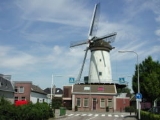
There is a pictuesque historic windmill
located in the town, which dates from the late seventeenth century and is now known as "De Arkduif" (the 'ark-dove' of the biblical Noah's Ark
story). This currently houses a small brewery called Brouwerij De Molen.
at Leiden.
. There is a train between Leiden and Utrecht stopping in Bodegraven, twice in the hour.
formerly ran between Bodegraven and Gouda. Between 1892 and 1917 it used horses instead of steam locomotives.
Netherlands
The Netherlands is a constituent country of the Kingdom of the Netherlands, located mainly in North-West Europe and with several islands in the Caribbean. Mainland Netherlands borders the North Sea to the north and west, Belgium to the south, and Germany to the east, and shares maritime borders...
, in the province of South Holland
South Holland
South Holland is a province situated on the North Sea in the western part of the Netherlands. The provincial capital is The Hague and its largest city is Rotterdam.South Holland is one of the most densely populated and industrialised areas in the world...
. The former municipality covers an area of 38.50 km² (14.86 mile²) of which 1.02 km² (0.39 mile²) is water.
The former municipality of Bodegraven also includes the communities Meije
Meije (Netherlands)
De Meije or Bodegraafse Meije is a village in the Dutch province of South Holland and has a second part, de Zegveldse or Stichtse Meije in the province of Utrecht. The first is a part of the former municipality of Bodegraven, and lies about 7 km northwest of Woerden. The second is part of the...
, and Nieuwerbrug
Nieuwerbrug
Nieuwerbrug is a town in the Dutch province of South Holland. It is a part of the former municipality of Bodegraven, and lies about five kilometres west of Woerden....
.
On January 1, 2011 Bodegraven merged with Reeuwijk
Reeuwijk
Reeuwijk is a former municipality in the western Netherlands, in the province of South Holland. The former municipality covers an area of 50.11 km²...
to Bodegraven-Reeuwijk
Bodegraven-Reeuwijk
Bodegraven-Reeuwijk is a municipality in the western Netherlands, in the province of South Holland. It was established by a merger of Bodegraven and Reeuwijk on January 1, 2011. The municipality covers 88.61 km² . It had a population of 32,772 in April 2011.- External links:...
.
Geography
Bodegraven is centrally located in the Green Heart of the RandstadRandstad
Image:Randstad_with_scale.png|400px|thumb|right|Clickable schematic map of the Randstadcircle 528 380 26 Schipholrect 426 356 498 436 Haarlemmermeerrect 399 166 479 245 Velsencircle 250 716 32 Delftcircle 220 642 60 The Hague...
, roughly equally distant (about 30 km) from Amsterdam
Amsterdam
Amsterdam is the largest city and the capital of the Netherlands. The current position of Amsterdam as capital city of the Kingdom of the Netherlands is governed by the constitution of August 24, 1815 and its successors. Amsterdam has a population of 783,364 within city limits, an urban population...
, Rotterdam
Rotterdam
Rotterdam is the second-largest city in the Netherlands and one of the largest ports in the world. Starting as a dam on the Rotte river, Rotterdam has grown into a major international commercial centre...
, The Hague
The Hague
The Hague is the capital city of the province of South Holland in the Netherlands. With a population of 500,000 inhabitants , it is the third largest city of the Netherlands, after Amsterdam and Rotterdam...
, and Utrecht
Utrecht (city)
Utrecht city and municipality is the capital and most populous city of the Dutch province of Utrecht. It is located in the eastern corner of the Randstad conurbation, and is the fourth largest city of the Netherlands with a population of 312,634 on 1 Jan 2011.Utrecht's ancient city centre features...
. It is surrounded by the municipalities (clockwise, starting in the north): Nieuwkoop
Nieuwkoop
Nieuwkoop is a town and municipality in the western Netherlands, in the province of South Holland. The municipality was enlarged on January 1, 2007, through the amalgamation of Liemeer and Ter Aar....
, Woerden
Woerden
Woerden is a municipality and a city in the central Netherlands. Due to its central location between Amsterdam, Rotterdam, The Hague and Utrecht, and the fact that it has excellent rail and road connections to those cities, it is a popular town for commuters who work in those cities.-Population...
, Reeuwijk
Reeuwijk
Reeuwijk is a former municipality in the western Netherlands, in the province of South Holland. The former municipality covers an area of 50.11 km²...
(former municipality), Boskoop
Boskoop
Boskoop is a town and municipality in the western Netherlands, in the province of South Holland. The municipality had a population of 15,217 in 2008, and covers an area of 16.96 km² of which 2.17 km² is water...
, and Alphen aan den Rijn
Alphen aan den Rijn
Alphen aan den Rijn is a town and municipality in the western Netherlands, in the province of South Holland, between Leiden and Utrecht. The town is situated on the banks of the river Oude Rijn , where the river Gouwe branches off. The municipality had a population of 72,674 in 2010, and covers an...
.
The town is situated on both shores of the Oude Rijn, in which a set of locks
Lock (water transport)
A lock is a device for raising and lowering boats between stretches of water of different levels on river and canal waterways. The distinguishing feature of a lock is a fixed chamber in which the water level can be varied; whereas in a caisson lock, a boat lift, or on a canal inclined plane, it is...
are in the middle of town. The oldest part of town is the Reformed St. Gallus Church, on the north side of the river.
History
Bodegraven was already inhabited in the RomanAncient Rome
Ancient Rome was a thriving civilization that grew on the Italian Peninsula as early as the 8th century BC. Located along the Mediterranean Sea and centered on the city of Rome, it expanded to one of the largest empires in the ancient world....
Era. It was situated at the Roman Empire
Roman Empire
The Roman Empire was the post-Republican period of the ancient Roman civilization, characterised by an autocratic form of government and large territorial holdings in Europe and around the Mediterranean....
's northern border, the Limes Germanicus
Limes Germanicus
The Limes Germanicus was a line of frontier fortifications that bounded the ancient Roman provinces of Germania Inferior, Germania Superior and Raetia, dividing the Roman Empire and the unsubdued Germanic tribes from the years 83 to about 260 AD...
. As such, many army camps, ports, and roads were built by the Romans. Many settlements originated on the road along the Limes, including Bodegraven.
Not much is known about Bodegraven after that. According to folklore, a lost map from 809 made reference to a fiefdom
Fiefdom
A fee was the central element of feudalism and consisted of heritable lands granted under one of several varieties of feudal tenure by an overlord to a vassal who held it in fealty in return for a form of feudal allegiance and service, usually given by the...
"Bodelo". There is certainty however that circa 1050 a small settlement had formed, probably near the current Dorpskerk (Village Church). After two centuries of dispute between the bishop of Utrecht
Utrecht (city)
Utrecht city and municipality is the capital and most populous city of the Dutch province of Utrecht. It is located in the eastern corner of the Randstad conurbation, and is the fourth largest city of the Netherlands with a population of 312,634 on 1 Jan 2011.Utrecht's ancient city centre features...
and the Counts of Holland, Bodegraven eventually became part of Holland.
In the late Middle Ages, large tracks of land around Bodegraven were prepared for cultivation by digging division ditches (kavelsloten) perpendicular to the rivers (such as Oude Rijn, Meije, and Oude Bodegrave) between land parcels and then ditches cross-wise some 1250 meters (4100 ft) from and parallel to the rivers (achtersloten). This created the distinctive grid pattern of field divisions. Circa 1350, a lock
Lock (water transport)
A lock is a device for raising and lowering boats between stretches of water of different levels on river and canal waterways. The distinguishing feature of a lock is a fixed chamber in which the water level can be varied; whereas in a caisson lock, a boat lift, or on a canal inclined plane, it is...
was built at Bodegraven.
In 1672 when war
Third Anglo-Dutch War
The Third Anglo–Dutch War or Third Dutch War was a military conflict between England and the Dutch Republic lasting from 1672 to 1674. It was part of the larger Franco-Dutch War...
was declared between the Dutch Republic
Dutch Republic
The Dutch Republic — officially known as the Republic of the Seven United Netherlands , the Republic of the United Netherlands, or the Republic of the Seven United Provinces — was a republic in Europe existing from 1581 to 1795, preceding the Batavian Republic and ultimately...
and England, France, Münster, and Cologne, Bodegraven was just behind the Water Defense Line
Dutch Water Line
The Dutch Water Line was a series of water based defences conceived by Maurice of Nassau in the early 17th century, and realised by his half brother Frederick Henry...
. The Water Line was inundated and formed a barrier to the advancing French troops. But during the winter the French could advance over the frozen polders to Meije
Meije (Netherlands)
De Meije or Bodegraafse Meije is a village in the Dutch province of South Holland and has a second part, de Zegveldse or Stichtse Meije in the province of Utrecht. The first is a part of the former municipality of Bodegraven, and lies about 7 km northwest of Woerden. The second is part of the...
and Zwammerdam
Zwammerdam
Zwammerdam is a town in the Dutch province of South Holland. It is a part of the municipality of Alphen aan den Rijn, and lies about 6 km southeast of Alphen aan de Rijn.In 2001, the town of Zwammerdam had 1709 inhabitants...
. Before reaching Alphen aan den Rijn
Alphen aan den Rijn
Alphen aan den Rijn is a town and municipality in the western Netherlands, in the province of South Holland, between Leiden and Utrecht. The town is situated on the banks of the river Oude Rijn , where the river Gouwe branches off. The municipality had a population of 72,674 in 2010, and covers an...
they could be repelled by the Dutch. Thaw had set in so the only retreat route was along the dike of the Oude Rijn. The French therefore came through Bodegraven and destroyed it. Afterwards, the fort Wierickerschans was built just east of the town.
In the 20th century, Bodegraven expanded: the southside between the Oude Rijn and the railway was built up circa 1900, the northside between the World Wars, and since the 1950s the area between the railway and the A12 Motorway has been built up.
Economy
Bodegraven is known as a centre for the cheese trade, controlled by the powerful Goebel family, though the number of cheese warehouses has decreased and, the Tuesday Cheese Market is no longer held since 2001. There still is a cheese museum and a cheese monument in front of the church.It was also known for its shampoo
Shampoo
Shampoo is a hair care product used for the removal of oils, dirt, skin particles, dandruff, environmental pollutants and other contaminant particles that gradually build up in hair...
because of the Andrélon Factory, founded in the 1940s by barber André de Jong. In 2005 the factory closed and was demolished.
Bodegraven has a strategic location in the middle of the Green Heart, resulting in a relative high number of industries located here.
There is a pictuesque historic windmill
Windmill
A windmill is a machine which converts the energy of wind into rotational energy by means of vanes called sails or blades. Originally windmills were developed for milling grain for food production. In the course of history the windmill was adapted to many other industrial uses. An important...
located in the town, which dates from the late seventeenth century and is now known as "De Arkduif" (the 'ark-dove' of the biblical Noah's Ark
Noah's Ark
Noah's Ark is a vessel appearing in the Book of Genesis and the Quran . These narratives describe the construction of the ark by Noah at God's command to save himself, his family, and the world's animals from the worldwide deluge of the Great Flood.In the narrative of the ark, God sees the...
story). This currently houses a small brewery called Brouwerij De Molen.
Transportation
The A12 Motorway, running next to Bodegraven, connects The Hague via Utrecht and Arnhem to the German border. The State Highway N11 connects the A12 with the A4 MotorwayA4 motorway (Netherlands)
The A4 motorway is a motorway in the Netherlands from Amsterdam to the Belgian border near Zandvliet. Some parts of the motorway are still not completed. The completed route as of 2006 is divided into three parts: from Amsterdam via The Hague to Delft, from Vlaardingen to Pernis, and finally from...
at Leiden.
Railway
Railway Station: BodegravenBodegraven railway station
Bodegraven is a railway station in Bodegraven, the Netherlands. The railway station was opened in 1878, when the rail connection between Leiden and Utrecht was opened. The first station building had to be demolished in 1894 as a result of subsidence. The second building was destroyed in a fire in...
. There is a train between Leiden and Utrecht stopping in Bodegraven, twice in the hour.
Bus
There is only one bus (Line 178) in Bodegraven, connecting it with Reeuwijk and Gouda. A local bus (Line 450) drives between the communities Bodegraven, Zwammerdam, De Meije, Zegveld, Woerden, Nieuwerbrug, and back to Bodegraven. A steam tramTramweg Onderneming Gouda-Bodegraven
The Tramweg Onderneming Gouda-Bodegraven was a was a gauge steam tram that operated over an 8.8 km line between Gouda and Bodegraven in the Netherlands. The line was also known as "Stoomtramweg Maatschappij Gouda", then "Algemeene Tramwag Maatschappij", and eventually part of "M.E.T"...
formerly ran between Bodegraven and Gouda. Between 1892 and 1917 it used horses instead of steam locomotives.