

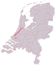
A4 motorway (Netherlands)
Encyclopedia
Netherlands
The Netherlands is a constituent country of the Kingdom of the Netherlands, located mainly in North-West Europe and with several islands in the Caribbean. Mainland Netherlands borders the North Sea to the north and west, Belgium to the south, and Germany to the east, and shares maritime borders...
from Amsterdam
Amsterdam
Amsterdam is the largest city and the capital of the Netherlands. The current position of Amsterdam as capital city of the Kingdom of the Netherlands is governed by the constitution of August 24, 1815 and its successors. Amsterdam has a population of 783,364 within city limits, an urban population...
to the Belgian
Belgium
Belgium , officially the Kingdom of Belgium, is a federal state in Western Europe. It is a founding member of the European Union and hosts the EU's headquarters, and those of several other major international organisations such as NATO.Belgium is also a member of, or affiliated to, many...
border near Zandvliet
Zandvliet
Zandvliet is a Belgian town forming part of the Antwerp district of Berendrecht-Zandvliet-Lillo. The place dates back to 1135 when it was known as Santflit, meaning "a navigable passage through sand"....
. Some parts of the motorway are still not completed. The completed route as of 2006 is divided into three parts: from Amsterdam via The Hague
The Hague
The Hague is the capital city of the province of South Holland in the Netherlands. With a population of 500,000 inhabitants , it is the third largest city of the Netherlands, after Amsterdam and Rotterdam...
to Delft
Delft
Delft is a city and municipality in the province of South Holland , the Netherlands. It is located between Rotterdam and The Hague....
, from Vlaardingen
Vlaardingen
Vlaardingen is a town in South Holland in the Netherlands. It is located on the north bank of the Nieuwe Maas/Nieuwe Waterweg river at the confluence with the Oude Maas...
(junction Kethelplein) to Pernis
Pernis (Netherlands)
thumb|200px|right|Pernis in 1865.Pernis is a village and district of the municipality of Rotterdam, South Holland, Netherlands. The district has a population of 4,560 on a total area size of 1.60 km². Pernis is not a full submunicipality of Rotterdam, but the former independent municipality...
, and finally from Bergen op Zoom
Bergen op Zoom
Bergen op Zoom is a municipality and a city located in the south of the Netherlands.-History:Bergen op Zoom was granted city status probably in 1266. In 1287 the city and its surroundings became a lordship as it was separated from the lordship of Breda. The lordship was elevated to a margraviate...
to the Belgian border. The total length of the completed route is 115 kilometers.
The construction of the missing link from Delft to Vlaardingen has always been very controversial, but minister
Minister (government)
A minister is a politician who holds significant public office in a national or regional government. Senior ministers are members of the cabinet....
of Transport
Transport
Transport or transportation is the movement of people, cattle, animals and goods from one location to another. Modes of transport include air, rail, road, water, cable, pipeline, and space. The field can be divided into infrastructure, vehicles, and operations...
and Waterworks
Waterway
A waterway is any navigable body of water. Waterways can include rivers, lakes, seas, oceans, and canals. In order for a waterway to be navigable, it must meet several criteria:...
Karla Peijs
Karla Peijs
Karla Maria Henriëtte Peijs is a Dutch politician of the CDA. She was minister of Transport and Waterworks in the second and third Balkenende cabinet. In August 2006 she announced she would not be accepting a position in a new cabinet. On 1 March 2007 she was appointed Queen's Commissioner for the...
authorised the construction of this link on 14 May 2006. Some of the roadbed preparation has been completed in this section, starting in 1968. A further extension was planned for this motorway from its southern terminus to the A29
A29 motorway (Netherlands)
The A29 motorway is a motorway in the Netherlands. It is approximately 31 kilometers in length. The A29 is located in the Dutch provinces South Holland and North Brabant.No European routes follow the A29 motorway.- Section Klaaswaal-Dinteloord :...
near Klaaswaal. Very little roadwork has been completed in this section, though right-of-way has been acquired for the A29 interchange.
Midden Delfland missing link
The A4 connects three of the four most important cities in The Netherlands, but there are still sections missing. A notorious 7000 meter gap lies between Delft and SchiedamSchiedam
Schiedam is a city and municipality in the province of South Holland in the Netherlands. It is part of the Rotterdam metropolitan area. The city is located west of Rotterdam, east of Vlaardingen and south of Delft...
, which causes huge traffic jams on the adjacent A13
A13 motorway (Netherlands)
The A13 motorway is a motorway in the Netherlands connecting the cities The Hague and Rotterdam.The 17 kilometer long, highly congested motorway, is the only current motorway connection between these two cities. It is a dual carriageway with three lanes in each direction. The maximum speed on the...
connecting The Hague and Rotterdam
Rotterdam
Rotterdam is the second-largest city in the Netherlands and one of the largest ports in the world. Starting as a dam on the Rotte river, Rotterdam has grown into a major international commercial centre...
.
Plans to close this gap were made decades ago, but there has not been any construction yet.
Overview
1957: Road 19 adopted in the national highway plan of 1957.
1965: Route set by the government.
1968: Start of the construction of the embankment where the road is supposed to run across
1976: Government stopped the construction of the A4.
1985: Government voted in favor of construction.
1998: Finances for A4 diverted to construction of railway tunnels.
2006: Costs of the construction have risen to 700 million for 7 kilometers.
2009: Dutch government decided that construction will start.
2010: September 2: record of decision by minister Camiel Eurlings
Camiel Eurlings
Camiel Eurlings is a former Dutch politician and a member of the Christian Democratic Appeal . He was the minister at the Ministry of Transport, Public Works and Water Management from 22 February 2007 to 14 October 2010...
.
2011: July 6: the Council of State dismisses all appeals against the record of decision.
2011: autumn: construction will commence.
2015: motorway completed.
Benelux - Klaaswaal missing link
This section should connect the existing A4 section west of Rotterdam towards Belgium. The Benelux junction is built so construction for this part of the A4 would be easy. This missing link creates heavy traffic jams on the nearby A29 and A15A15 motorway (Netherlands)
The Dutch Rijksweg 15 is a set of two motorways in the Netherlands, the A15 and the A18. The map on the right-hand side shows these two parts of this Rijksweg 15.- Connection between A15 and A18 :...
motorways. This section is about 12 kilometres long. Supporters of the scheme contend that cities like Hoogvliet
Hoogvliet
Hoogvliet is a town and separate borough within Rotterdam in the Netherlands. As of 1 January 2004, it had 36,619 inhabitants. There is also a named after the district.-History:...
, Spijkenisse
Spijkenisse
Spijkenisse is a town and municipality in the western Netherlands, in the province of South Holland. The municipality had a population of 74,482 in 2006, and covers an area of 30.23 km²...
, Barendrecht
Barendrecht
Barendrecht is a town in the western Netherlands, in the province of South Holland. The municipality had a population of 43,104 in 2007, and covers an area of 21.72 km² of which 1.45 km² is water....
and Rotterdam would be relieved from traffic jams, however environmentalists oppose the A4, saying it would only create more traffic.
Overview
1961: Route approved as national road 19 by the government.
2005: Space reserved in the mobility vision of the government.
Section between Klaaswaal and Dinteloord
The motorway section between Klaaswaal and Dinteloord is currently known as A29, but the intention is to include it in the A4 motorway in the future. When the missing links between Benelux and Klaaswaal, and between Dinteloord and Halsteren are completed, this section will be renumbered to create a continuous motorway A4 between junction Benelux and the Belgian border. For now, however, this section of road is still being numbered as A29, to avoid confusion with motorists.
Dinteloord - Halsteren missing link
This section will connect the now named A29 motorway (national road 4) to the city of Bergen op Zoom and the Belgium region of Antwerp. Constructing this missing link would relieve the A16A16 motorway (Netherlands)
The A16 motorway is a motorway in the Netherlands. It runs from the interchange Terbregseplein in the northeastern part of Rotterdam, towards the Belgian border near Breda.- Speed limit :...
from its notorious traffic jams near Dordrecht, the Moerdijk bridge and adjacent roads like the A17
A17 motorway (Netherlands)
The A17 motorway is a motorway in the Netherlands. It runs from the interchange Klaverpolder, just south of the Moerdijk bridge in the A16 motorway, towards the interchange De Stok with the A58 motorway, near Roosendaal....
motorway.
However, as of 2007 there is still a 16 kilometer section missing, but road construction is likely underway, as there are 2 possible routes; east and west of the small city of Steenbergen. An eastern bypass would be shortest, but it is said that it would through the Mark river area, which is seen as an important natural aspect in the region by some.
A western route is longer and would require an aqueduct which is much more expensive.
The Minister of Transport, Camiel Eurlings
Camiel Eurlings
Camiel Eurlings is a former Dutch politician and a member of the Christian Democratic Appeal . He was the minister at the Ministry of Transport, Public Works and Water Management from 22 February 2007 to 14 October 2010...
, opened the so-called Halsteren bypass at December 15, 2007. This bypass consists of a 4 kilometers long extension from the existing exit 27 to the N286 road north of the town Halsteren, to relieve the N259 road through that town.
Overview
1971: Route approved as national road 19 by the government
2005: Finances saved, there is a budget of 218 million euros available
2006: Bypass construction near Halsteren awarded to construction companies.
2007: Government chooses to construct the A4 west of Steenbergen.
end 2010: Building highway has commenced, according to plannings, the road will be finished in 2013
Exit list
| Province | Municipality | km. | # Exit number An exit number is a number assigned to a road junction, usually an exit from a freeway. It is usually marked on the same sign as the destinations of the exit, as well as a sign in the gore.... |
Name | Roads | Notes |
|---|---|---|---|---|---|---|
| North Holland North Holland North Holland |West Frisian]]: Noard-Holland) is a province situated on the North Sea in the northwest part of the Netherlands. The provincial capital is Haarlem and its largest city is Amsterdam.-Geography:... |
Amsterdam Amsterdam Amsterdam is the largest city and the capital of the Netherlands. The current position of Amsterdam as capital city of the Kingdom of the Netherlands is governed by the constitution of August 24, 1815 and its successors. Amsterdam has a population of 783,364 within city limits, an urban population... |
0 |  |
Interchange Interchange (road) In the field of road transport, an interchange is a road junction that typically uses grade separation, and one or more ramps, to permit traffic on at least one highway to pass through the junction without directly crossing any other traffic stream. It differs from a standard intersection, at which... De Nieuwe Meer |
A10 A10 motorway (Netherlands) The A10 motorway is a motorway in the Netherlands. This motorway is the ring road around the city of Amsterdam.The motorway has a length of 32 km... |
|
| 2 |  1 1 |
Sloten Sloten Sloten is the name of two towns in the Netherlands:* Sloten, Friesland, the city in the municipality of Gaasterlân-Sleat* Sloten, Amsterdam, village in North Holland... |
||||
| Haarlemmermeer Haarlemmermeer Haarlemmermeer is a municipality in the Netherlands, in the province of North Holland. It is a polder, consisting of land reclaimed from water, and the name Haarlemmermeer means Haarlem's Lake, still referring to the body of water from which the region was reclaimed in the 19th century.Its main... |
4 | |
Interchange Badhoevedorp | A9 A9 motorway (Netherlands) The A9 motorway is a motorway in the Netherlands. The motorway starts off by going from the A1 at Diemen to the A2 at junction 'Holendrecht'... |
||
| 7 | 2 |
Schiphol Airport | ||||
| 11 | |
Interchange De Hoek | A5 A5 motorway (Netherlands) The A5 motorway is a motorway in the Netherlands. With a length of only , it is one of the shortest motorways in the country.The A5 serves as a connection between the A4 motorway at the interchange De Hoek and the A9 motorway at the interchange Raasdorp... |
Northbound exit and southbound entrance only | ||
| 11 | 3 |
Hoofddorp Hoofddorp Hoofddorp is the main town of the Haarlemmermeer municipality in the province of North Holland in the Netherlands. In 2009, the population was just over 73,000... , Aalsmeer Aalsmeer Aalsmeer is a municipality and a town in the Netherlands, in the province of North Holland. Its name is derived from the Dutch for eel and lake . Aalsmeer is bordered by the Westeinderplassen lake, the largest open water of the Randstad, and the Ringvaart Canal... (N201) |
N201 | |||
| 18/19 | 4 |
Nieuw Vennep | N207 | |||
| 18/19 | |
Interchange Burgerveen | A44 | Southbound exit and northbound entrance only | ||
| South Holland South Holland South Holland is a province situated on the North Sea in the western part of the Netherlands. The provincial capital is The Hague and its largest city is Rotterdam.South Holland is one of the most densely populated and industrialised areas in the world... |
Alkemade Alkemade Alkemade is a former municipality in the western Netherlands, in the province of South Holland. Before its merger with Jacobswoude, the municipality covered an area of 30.91 km² of which 3.94 km² is water... |
23 | 5 |
Roelofarendsveen | ||
| Jacobswoude Jacobswoude Jacobswoude is a former municipality in the western Netherlands, in the province of South Holland, now part of municipality Kaag en Braassem. Before the merger with Alkemade, the municipality covered an area of 41.37 km² of which 4.88 km² is water, mainly the lakes Braassemermeer and... |
29 | 6 |
Hoogmade Hoogmade Hoogmade is a village in the Dutch province of South Holland. It is located about 7 km east of Leiden, in the municipality of Kaag en Braassem.Hoogmade was a separate municipality between 1817 and 1855, when it merged with Woubrugge.... |
|||
| Zoeterwoude Zoeterwoude Zoeterwoude is a municipality in the western Netherlands, in the province of South Holland. The municipality covers 21.91 km² . It had a population of 8,526 in 2004.... |
33 | 6a |
Zoeterwoude-Rijndijk Zoeterwoude-Rijndijk Zoeterwoude-Rijndijk is a village in the Dutch province of South Holland. It is a part of the municipality of Zoeterwoude, and lies about southeast of Leiden.... |
N11 | ||
| 35 | 7 |
Zoeterwoude-Dorp Zoeterwoude-Dorp Zoeterwoude-Dorp is a town in the Dutch province of South Holland. It is a part of the municipality of Zoeterwoude, and lies about 6 km south of Leiden.In 2001, the town of Zoeterwoude-Dorp had 4605 inhabitants... |
N206 | |||
| Leidschendam-Voorburg Leidschendam-Voorburg Leidschendam-Voorburg is a municipality in the western Netherlands, in the province of South Holland. The municipality had a population of 73,832 in 2004, and covers an area of 35.68 km² of which 2.86 km² is water.-Origin:... |
44 | 8 |
Leidschendam Leidschendam Leidschendam is a town and former municipality in the province of South Holland of the Netherlands. Along with Voorburg and Stompwijk, it is part of the municipality Leidschendam-Voorburg.- History :... |
N14 | ||
| 46 | |
Interchange Prins Clausplein | A12 A12 motorway (Netherlands) The A12 motorway is a motorway in the Netherlands. The road connects the city of The Hague, with the German border, near Zevenaar, and the German Autobahn BAB 3... |
|||
| The Hague The Hague The Hague is the capital city of the province of South Holland in the Netherlands. With a population of 500,000 inhabitants , it is the third largest city of the Netherlands, after Amsterdam and Rotterdam... |
47 | |
Interchange Ypenburg | A13 A13 motorway (Netherlands) The A13 motorway is a motorway in the Netherlands connecting the cities The Hague and Rotterdam.The 17 kilometer long, highly congested motorway, is the only current motorway connection between these two cities. It is a dual carriageway with three lanes in each direction. The maximum speed on the... |
Southbound entrance through intersection with traffic lights | |
| Rijswijk Rijswijk Rijswijk is a town and municipality in the western Netherlands, in the province of South Holland. It is a suburb of The Hague and covers an area of 14.48 km² .... |
48 | 9 |
Rijswijk Rijswijk Rijswijk is a town and municipality in the western Netherlands, in the province of South Holland. It is a suburb of The Hague and covers an area of 14.48 km² .... -Centrum |
Centrum means (town) centre | ||
| 49 | 10 |
Plaspoelpolder | ||||
| 51 | 11 |
Rijswijk Rijswijk Rijswijk is a town and municipality in the western Netherlands, in the province of South Holland. It is a suburb of The Hague and covers an area of 14.48 km² .... |
||||
| The Hague The Hague The Hague is the capital city of the province of South Holland in the Netherlands. With a population of 500,000 inhabitants , it is the third largest city of the Netherlands, after Amsterdam and Rotterdam... |
53 | 12 |
Den Haag-Zuid | N211 | Den Haag is Dutch for The Hague; zuid means south | |
| Midden-Delfland Midden-Delfland Midden-Delfland is a municipality in the Westland region in the province of South Holland in the Netherlands. It had a population of 17,072 in 2004, and covers an area of 49.38 km² of which 1.93 km² is water... |
55 | 13 |
Den Hoorn | N223 | ||
| Delft Delft Delft is a city and municipality in the province of South Holland , the Netherlands. It is located between Rotterdam and The Hague.... |
57 | 14 |
Delft Delft Delft is a city and municipality in the province of South Holland , the Netherlands. It is located between Rotterdam and The Hague.... -Zuid |
|||
| Midden Delfland missing link | ||||||
| Schiedam Schiedam Schiedam is a city and municipality in the province of South Holland in the Netherlands. It is part of the Rotterdam metropolitan area. The city is located west of Rotterdam, east of Vlaardingen and south of Delft... |
70 | |
Interchange Kethelplein | A20 A20 motorway (Netherlands) The A20 motorway is a motorway in the Netherlands. It is approximately 39 kilometers in length.The A20 is entirely located in the Dutch province South Holland and connects the N213 road from the Westland municipality with the cities of Rotterdam and Gouda, where it connects to the A12 motorway at... |
||
| Vlaardingen Vlaardingen Vlaardingen is a town in South Holland in the Netherlands. It is located on the north bank of the Nieuwe Maas/Nieuwe Waterweg river at the confluence with the Oude Maas... |
72 | 16 |
Vlaardingen Vlaardingen Vlaardingen is a town in South Holland in the Netherlands. It is located on the north bank of the Nieuwe Maas/Nieuwe Waterweg river at the confluence with the Oude Maas... -Oost |
Oost means east | ||
| Rotterdam Rotterdam Rotterdam is the second-largest city in the Netherlands and one of the largest ports in the world. Starting as a dam on the Rotte river, Rotterdam has grown into a major international commercial centre... |
75 | 17 |
Pernis Pernis (Netherlands) thumb|200px|right|Pernis in 1865.Pernis is a village and district of the municipality of Rotterdam, South Holland, Netherlands. The district has a population of 4,560 on a total area size of 1.60 km². Pernis is not a full submunicipality of Rotterdam, but the former independent municipality... |
|||
| 76 | |
Interchange Benelux | A15 A15 motorway (Netherlands) The Dutch Rijksweg 15 is a set of two motorways in the Netherlands, the A15 and the A18. The map on the right-hand side shows these two parts of this Rijksweg 15.- Connection between A15 and A18 :... |
|||
| Benelux-Klaaswaal missing link | ||||||
A29 motorway (Netherlands) The A29 motorway is a motorway in the Netherlands. It is approximately 31 kilometers in length. The A29 is located in the Dutch provinces South Holland and North Brabant.No European routes follow the A29 motorway.- Section Klaaswaal-Dinteloord :... . |
||||||
| North Brabant North Brabant North Brabant , sometimes called Brabant, is a province of the Netherlands, located in the south of the country, bordered by Belgium in the south, the Meuse River in the north, Limburg in the east and Zeeland in the west.- History :... |
Dinteloord-Halsteren missing link | |||||
| Bergen op Zoom Bergen op Zoom Bergen op Zoom is a municipality and a city located in the south of the Netherlands.-History:Bergen op Zoom was granted city status probably in 1266. In 1287 the city and its surroundings became a lordship as it was separated from the lordship of Breda. The lordship was elevated to a margraviate... |
229 | 26 |
Halsteren Halsteren Halsteren is a village in the Dutch province of North Brabant. It is located in the municipality of Bergen op Zoom, about 1 km north of that city. Halsteren has an old church from 1457 and a new church, built in 1919... / Tholen Tholen Tholen is a municipality in the southwest of the Netherlands. The municipality of Tholen has lent its name from the town of Tholen, which is the largest population center in the municipality.... |
N259, N286 | ||
| 233 | 27 |
Bergen op Zoom Bergen op Zoom Bergen op Zoom is a municipality and a city located in the south of the Netherlands.-History:Bergen op Zoom was granted city status probably in 1266. In 1287 the city and its surroundings became a lordship as it was separated from the lordship of Breda. The lordship was elevated to a margraviate... -Noord |
Noord means north | |||
| 234 | |
Interchange Zoomland | A58 A58 motorway (Netherlands) The A58 motorway is a motorway in the Netherlands. It is approximately 145 kilometers in length. The A58 is located in the Dutch provinces of North Brabant and Zeeland.... |
|||
| 235 | 28 |
Bergen op Zoom Bergen op Zoom Bergen op Zoom is a municipality and a city located in the south of the Netherlands.-History:Bergen op Zoom was granted city status probably in 1266. In 1287 the city and its surroundings became a lordship as it was separated from the lordship of Breda. The lordship was elevated to a margraviate... |
||||
| 236 | 29 |
Bergen op Zoom Bergen op Zoom Bergen op Zoom is a municipality and a city located in the south of the Netherlands.-History:Bergen op Zoom was granted city status probably in 1266. In 1287 the city and its surroundings became a lordship as it was separated from the lordship of Breda. The lordship was elevated to a margraviate... -Zuid |
||||
| Woensdrecht Woensdrecht Woensdrecht is a municipality and a town in the southern Netherlands.Woensdrecht is mainly known for Woensdrecht Air Base. In 1983 it was decided that the US would station 48 nuclear armed cruise missiles here, unless the USSR would reduce the number of SS-20 missiles to 378. Since the number was... |
241 | 30 |
Hoogerheide Hoogerheide Hoogerheide is a village in the municipality of Woensdrecht, North Brabant, Netherlands. The name "Hoogerheide" means "High Heath" in English. The Grand Prix Adri van der Poel cyclo-cross race is held annually in Hoogerheide.-External links:*... |
N289 | ||
| 243 | |
Interchange Markiezaat | A58 A58 motorway (Netherlands) The A58 motorway is a motorway in the Netherlands. It is approximately 145 kilometers in length. The A58 is located in the Dutch provinces of North Brabant and Zeeland.... |
|||
| 250 | 11 |
Zandvliet Zandvliet Zandvliet is a Belgian town forming part of the Antwerp district of Berendrecht-Zandvliet-Lillo. The place dates back to 1135 when it was known as Santflit, meaning "a navigable passage through sand".... (Belgium Belgium Belgium , officially the Kingdom of Belgium, is a federal state in Western Europe. It is a founding member of the European Union and hosts the EU's headquarters, and those of several other major international organisations such as NATO.Belgium is also a member of, or affiliated to, many... ) |
This Belgian exit is partially on Dutch soil | |||
 Border with Belgium; this road continues as the Belgian A12 Border with Belgium; this road continues as the Belgian A12A12 road (Belgium) The A12 is an incomplete motorway in Belgium. The road starts at the Dutch border near Zandvliet and goes to Antwerp. There the A12 goes onto the Antwerp ring road R1. Then the road goes via Wilrijk in the direction of Brussels . From here on, it has frontage roads on both sides... . |
||||||