
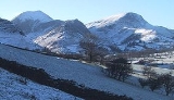
Hindscarth
Encyclopedia
Hindscarth is a mountain
between the valleys of Buttermere
and Newlands
, in the north-western part of the English
Lake District
. The fell's name is derived from two words from the Old Norse language, Hind and Skarth, and means the pass used by the red deer.
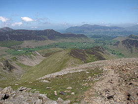
occupy the area between the rivers Derwent and Cocker, a broadly oval swathe of hilly country, elongated on a north-south axis. Two roads cross from east to west, dividing the fells into three convenient groups. Hindscarth stands in the southern sector. The principal ridge in this group of fells runs east from Buttermere, climbing over Robinson
, Hindscarth and Dale Head
. It then turns north, descending gradually toward Derwentwater, the main tops being High Spy
, Maiden Moor
and Catbells
.
The ridge from Robinson to Dale Head forms the heads of Little Dale and Newlands, bypassing the intervening summit of Hindscarth. This stands off to the north, forming the dividing wall between the two valleys. The long north west ridge steps down over several tiers of crag to the confluence of its bordering streams. The southern face of Hindscarth looks down over Honister Pass
.
and passes over the Scope End ridge before continuing up crags to the summit. Due to their proximity, Hindscarth and Robinson
are often combined into a single walk starting from Newlands. The fell is also part of a longer walk including Catbells
, High Spy
, Dale Head
and along the Littledale Edge ridge to Robinson — the Newlands Horseshoe.
of disrupted, sheared and folded mudstone
, siltstone
and sandstone
.
in the Lake District. The Goldscope mine has been designated as a major national important site by English Heritage
who have stated that it should receive priority treatment for its protection and preservation. The mine was opened in 1564 and developed in its early days by German miners, who worked its rich veins of lead
and copper
. The mine was considered so important in its early days that it was requisitioned for the Crown by Elizabeth I
from its then-owner, the Earl of Northumberland
. There are considerable spoil heaps on the Newlands Beck side of Scope End and the shaft inside the hillside was sunk to such a considerable depth that it became uneconomical to pump out the water, leading to the closure of the mine at the end of the 19th century.
amid some embedded rocks. Elsewhere there are patches of grass and gravel. A hundred yards south is a larger cairn, marked as a Shelter on Ordnance Survey
maps. The view north into the Newlands Valley is excellent, backed by Skiddaw
. All of the major fell groups with the exception of High Street
can be seen.
Mountain
Image:Himalaya_annotated.jpg|thumb|right|The Himalayan mountain range with Mount Everestrect 58 14 160 49 Chomo Lonzorect 200 28 335 52 Makalurect 378 24 566 45 Mount Everestrect 188 581 920 656 Tibetan Plateaurect 250 406 340 427 Rong River...
between the valleys of Buttermere
Buttermere
Buttermere is a lake in the English Lake District in North West England. The adjacent village of Buttermere takes its name from the lake. Historically within the former county of Cumberland, the lake is now within the county of Cumbria. It is owned by the National Trust, forming part of their...
and Newlands
Newlands Valley
The Newlands Valley is in the Lake District National Park in Cumbria, England. It is regarded as one of the most picturesque and quiet valleys in the national park, even though it is situated very close to the popular tourist town of Keswick and the busy A66 road.The valley forms part of the civil...
, in the north-western part of the English
England
England is a country that is part of the United Kingdom. It shares land borders with Scotland to the north and Wales to the west; the Irish Sea is to the north west, the Celtic Sea to the south west, with the North Sea to the east and the English Channel to the south separating it from continental...
Lake District
Lake District
The Lake District, also commonly known as The Lakes or Lakeland, is a mountainous region in North West England. A popular holiday destination, it is famous not only for its lakes and its mountains but also for its associations with the early 19th century poetry and writings of William Wordsworth...
. The fell's name is derived from two words from the Old Norse language, Hind and Skarth, and means the pass used by the red deer.
Topography
The North Western FellsNorth Western Fells
The North Western Fells are a group of hills in the English Lake District. Including such favourites as Catbells and Grisedale Pike, they occupy an oval area beneath the Buttermere and Borrowdale valley systems...
occupy the area between the rivers Derwent and Cocker, a broadly oval swathe of hilly country, elongated on a north-south axis. Two roads cross from east to west, dividing the fells into three convenient groups. Hindscarth stands in the southern sector. The principal ridge in this group of fells runs east from Buttermere, climbing over Robinson
Robinson (Lake District)
thumb|Robinson seen from the [[Ard Crags]] ridge, with Hindscarth to the leftRobinson is a fell in the English Lake District, its southern slopes descending to Buttermere, while its northern side is set in the Newlands Valley...
, Hindscarth and Dale Head
Dale Head
Dale Head is a fell in the northwestern sector of the Lake District, in northern England. It is 753 metres or 2,470 feet above sea level and stands immediately north of Honister Pass, the road between Borrowdale and Buttermere.-Topography:...
. It then turns north, descending gradually toward Derwentwater, the main tops being High Spy
High Spy
High Spy is a fell in the English Lake District it is situated on the ridge that separates the Newlands Valley from Borrowdale, eight kilometres south of Keswick.-Topography:...
, Maiden Moor
Maiden Moor
Maiden Moor is a fell in the English Lake District, it stands south of the town of Keswick and is part of the high ground that separates the Newlands Valley and Borrowdale, it has a modest height of and so fails to be mentioned on many UK mountain lists but it does have a separate chapter in...
and Catbells
Catbells
Catbells is a fell in the English Lake District in the county of Cumbria. It has a modest height of but despite this it is one of the most popular fells in the area. It is situated on the western shore of Derwent Water within of the busy tourist town of Keswick...
.
The ridge from Robinson to Dale Head forms the heads of Little Dale and Newlands, bypassing the intervening summit of Hindscarth. This stands off to the north, forming the dividing wall between the two valleys. The long north west ridge steps down over several tiers of crag to the confluence of its bordering streams. The southern face of Hindscarth looks down over Honister Pass
Honister Pass
The Honister Pass, also known as Honister Hause, is a mountain pass in the English Lake District. It is located on the B5289 road, linking Seatoller, in the valley of Borrowdale, to Gatesgarth at the southern end of Buttermere...
.
Ascents
A popular ascent starts from a parking area nearby Newlands ChurchNewlands Church
Newlands Church is a 16th century church situated less than 500 metres west of the hamlet of Little Town, Cumbria, England in the Newlands Valley of the Lake District...
and passes over the Scope End ridge before continuing up crags to the summit. Due to their proximity, Hindscarth and Robinson
Robinson (Lake District)
thumb|Robinson seen from the [[Ard Crags]] ridge, with Hindscarth to the leftRobinson is a fell in the English Lake District, its southern slopes descending to Buttermere, while its northern side is set in the Newlands Valley...
are often combined into a single walk starting from Newlands. The fell is also part of a longer walk including Catbells
Catbells
Catbells is a fell in the English Lake District in the county of Cumbria. It has a modest height of but despite this it is one of the most popular fells in the area. It is situated on the western shore of Derwent Water within of the busy tourist town of Keswick...
, High Spy
High Spy
High Spy is a fell in the English Lake District it is situated on the ridge that separates the Newlands Valley from Borrowdale, eight kilometres south of Keswick.-Topography:...
, Dale Head
Dale Head
Dale Head is a fell in the northwestern sector of the Lake District, in northern England. It is 753 metres or 2,470 feet above sea level and stands immediately north of Honister Pass, the road between Borrowdale and Buttermere.-Topography:...
and along the Littledale Edge ridge to Robinson — the Newlands Horseshoe.
Geology
Hindscarth is an example of the Buttermere Formation, an olistostromeOlistostrome
The term olistostrome is derived from olio - a dish of many ingredients or stew; a mixture of heterogeneous elements; hodgepodge. and stroma - a bed covering...
of disrupted, sheared and folded mudstone
Mudstone
Mudstone is a fine grained sedimentary rock whose original constituents were clays or muds. Grain size is up to 0.0625 mm with individual grains too small to be distinguished without a microscope. With increased pressure over time the platey clay minerals may become aligned, with the...
, siltstone
Siltstone
Siltstone is a sedimentary rock which has a grain size in the silt range, finer than sandstone and coarser than claystones.- Description :As its name implies, it is primarily composed of silt sized particles, defined as grains 1/16 - 1/256 mm or 4 to 8 on the Krumbein phi scale...
and sandstone
Sandstone
Sandstone is a sedimentary rock composed mainly of sand-sized minerals or rock grains.Most sandstone is composed of quartz and/or feldspar because these are the most common minerals in the Earth's crust. Like sand, sandstone may be any colour, but the most common colours are tan, brown, yellow,...
.
Mining
The northern ridge of Hindscarth which falls away to the Newlands valley has at its foot (at Scope End) one of the most famous former minesMining
Mining is the extraction of valuable minerals or other geological materials from the earth, from an ore body, vein or seam. The term also includes the removal of soil. Materials recovered by mining include base metals, precious metals, iron, uranium, coal, diamonds, limestone, oil shale, rock...
in the Lake District. The Goldscope mine has been designated as a major national important site by English Heritage
English Heritage
English Heritage . is an executive non-departmental public body of the British Government sponsored by the Department for Culture, Media and Sport...
who have stated that it should receive priority treatment for its protection and preservation. The mine was opened in 1564 and developed in its early days by German miners, who worked its rich veins of lead
Lead
Lead is a main-group element in the carbon group with the symbol Pb and atomic number 82. Lead is a soft, malleable poor metal. It is also counted as one of the heavy metals. Metallic lead has a bluish-white color after being freshly cut, but it soon tarnishes to a dull grayish color when exposed...
and copper
Copper
Copper is a chemical element with the symbol Cu and atomic number 29. It is a ductile metal with very high thermal and electrical conductivity. Pure copper is soft and malleable; an exposed surface has a reddish-orange tarnish...
. The mine was considered so important in its early days that it was requisitioned for the Crown by Elizabeth I
Elizabeth I of England
Elizabeth I was queen regnant of England and Ireland from 17 November 1558 until her death. Sometimes called The Virgin Queen, Gloriana, or Good Queen Bess, Elizabeth was the fifth and last monarch of the Tudor dynasty...
from its then-owner, the Earl of Northumberland
Earl of Northumberland
The title of Earl of Northumberland was created several times in the Peerages of England and Great Britain, succeeding the title Earl of Northumbria. Its most famous holders were the House of Percy , who were the most powerful noble family in Northern England for much of the Middle Ages...
. There are considerable spoil heaps on the Newlands Beck side of Scope End and the shaft inside the hillside was sunk to such a considerable depth that it became uneconomical to pump out the water, leading to the closure of the mine at the end of the 19th century.
Summit and View
The summit carries an untidy cairnCairn
Cairn is a term used mainly in the English-speaking world for a man-made pile of stones. It comes from the or . Cairns are found all over the world in uplands, on moorland, on mountaintops, near waterways and on sea cliffs, and also in barren desert and tundra areas...
amid some embedded rocks. Elsewhere there are patches of grass and gravel. A hundred yards south is a larger cairn, marked as a Shelter on Ordnance Survey
Ordnance Survey
Ordnance Survey , an executive agency and non-ministerial government department of the Government of the United Kingdom, is the national mapping agency for Great Britain, producing maps of Great Britain , and one of the world's largest producers of maps.The name reflects its creation together with...
maps. The view north into the Newlands Valley is excellent, backed by Skiddaw
Skiddaw
Skiddaw is a mountain in the Lake District National Park in England. With a summit at 931 m above sea level it is the fourth highest mountain in England. It lies just north of the town of Keswick, Cumbria, and dominates the skyline in this part of the northern lakes...
. All of the major fell groups with the exception of High Street
High Street (Lake District)
High Street is a fell in the English Lake District. At 828 metres , its summit is the highest point in the far eastern part of the national park. The fell is named after the Roman road which ran over the summit.-History and Naming:...
can be seen.