
Sca Fell
Encyclopedia
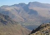
Sca Fell is a mountain
in the English
Lake District
. Its height of 964 metres (3,162 ft) makes it the second-highest mountain in England
after Scafell Pike
, from which it is separated by the col of Mickledore
.
Originally the name Sca Fell referred to the whole of the massif from Great End south to Slight Side
; only more recently has the general term become applied solely to the part of the fell
south of Mickledore
.
It was once believed that Sca Fell was the highest mountain in this part of the Lake District — it is much more prominent in views from many directions than its higher neighbour — with the three apparently inferior peaks to the north (those now known as Scafell Pike
, Ill Crag
and Broad Crag
) being known collectively as the "Pikes of Sca Fell".
in the west and upper Eskdale
to the east. The highest part of the fell is a ridge running south from Mickledore as far as Slight Side
, which is counted as a separate fell by most guidebooks. Despite regarding Slight Side as a separate entity, Wainwright
included the wide upland area beyond it to the south west as a part of Sca Fell. More modern guides have partitioned the plateau off as a further independent top, Great How.
The opposing flanks of Sca Fell are entirely different in character. Smooth slopes, lacking vegetation at higher levels but also devoid of any real interest, run down toward the head of Wast Water. On the east and north all is rock, walls of crag looming impressively over Eskdale.
Image:Annotated Scafell range.jpg|thumb|left|300px|The Scafell range as seen looking west from Crinkle Crags. (Interactive labels.)
rect 23 372 252 419 Slight Side (762m)
rect 173 794 560 834 Scafell East Buttress
rect 707 787 893 861 Esk Crag or Buttress (c. 750m)
rect 245 303 409 358 Sca Fell (964m)
rect 408 238 637 280 Mickledore (c.840m)
rect 544 174 826 213 South Summit (c. 950m)
rect 706 310 928 355 Scafell Pike (978m)
rect 870 238 1108 286 Broad Crag (934m)
rect 1043 308 1198 360 Ill Crag (935m)
rect 1238 311 1446 351 Great End (910m)
rect 0 0 1444 1085 Click hyperlink or button to expand
desc none
From the narrow ridge of Mickledore the northern face of Sca Fell rises precipitously, an unusually complete barrier to progress along a Lakeland ridge. At the top of the rise is Symonds Knott (3,146 ft), the northern top. The wall of crags — Scafell Crag to the west and the East Butress above the Eskdale side of Mickledore — has two main weaknesses. Running laterally across Scafell Crag is Lord's Rake, a scree filled chute with several intermediate cols
. It has two upper entrances onto the saddle separating Symonds Knott from the main summit. Formerly passable as a scramble, it suffered from a serious rock fall in 2002 — with subsequent further falls — and recent guidebooks do not consider it a viable route, although it is gradually becoming more stable. The second breach in the crags is Broad Stand, a series of sloping steps which drop down from Symonds Knott almost to Mickledore; however, these steepen immediately above Mickledore and cannot be negotiated safely except by rock-climbers. The main summit stands a little to the south of the saddle, all around being a sea of stones. An easy ridge then steps down southward over Long Green to Slight Side. On the east are Cam Spout Crag and the fine high waterfall after which it is named.
Beyond Slight Side is a rough upland with many craggy tops and a number of tarns
, before the southward descent finally ends in Lower Eskdale. South West of Sca Fell, below the scarp of Great How, is Burnmoor Tarn, one of the largest in Lakeland. Around 40 ft (12.2 m) deep it holds trout, perch and pike. The tarn is prevented from following what would appear the natural line of drainage into Miterdale by moraine
s, and empties southward, reaching the Esk at Beckfoot. Near the southern shore stands Burnmoor Lodge, once a keeper's cottage and a dwelling two miles (3 km) from the nearest road.
on a short rocky ridge. Northward is a saddle, marked by a large cross of stones and then the bouldery climb to Symonds Knott, the north top. This gives views straight down to Mickledore.
Scafell gives a very different view to that from its higher neighbour with Wastwater and the coastal plain given great prominence. There is a fine vista of the Western Fells
, together with Bowfell
and the Coniston Fells
.
s prevent a direct walking route, entailing a considerable loss of height to get round the obstacle. The direct route up the crags, known as Broad Stand, is a dangerous and exposed scramble
that has caused many accidents and injuries; it is usually treated as a rock climb
, with appropriate protection.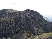 The classic ascent via Lord's Rake path from Wastwater is now threatened by unstable rocks following a rock fall in 2001. A pleasant but lengthy alternative begins from Boot in Eskdale
, following the River Esk
upstream, and scrambling up to the summit by way of Foxes Tarn. A gentler return can be made across moorland, by way of the Burnmoor Tarn. Also starting in Eskdale, the Terrace route can be followed from Wha House, first ascending Slight Side.
Scafell Crag, the massive north buttress of Sca Fell, is one of England's largest cliffs and has many famous rock climbs.
Mountain
Image:Himalaya_annotated.jpg|thumb|right|The Himalayan mountain range with Mount Everestrect 58 14 160 49 Chomo Lonzorect 200 28 335 52 Makalurect 378 24 566 45 Mount Everestrect 188 581 920 656 Tibetan Plateaurect 250 406 340 427 Rong River...
in the English
England
England is a country that is part of the United Kingdom. It shares land borders with Scotland to the north and Wales to the west; the Irish Sea is to the north west, the Celtic Sea to the south west, with the North Sea to the east and the English Channel to the south separating it from continental...
Lake District
Lake District
The Lake District, also commonly known as The Lakes or Lakeland, is a mountainous region in North West England. A popular holiday destination, it is famous not only for its lakes and its mountains but also for its associations with the early 19th century poetry and writings of William Wordsworth...
. Its height of 964 metres (3,162 ft) makes it the second-highest mountain in England
England
England is a country that is part of the United Kingdom. It shares land borders with Scotland to the north and Wales to the west; the Irish Sea is to the north west, the Celtic Sea to the south west, with the North Sea to the east and the English Channel to the south separating it from continental...
after Scafell Pike
Scafell Pike
Scafell Pike is the highest mountain in England at . It is located in Lake District National Park sometimes confused with the neighbouring Sca Fell, to which it is connected by the col of Mickledore...
, from which it is separated by the col of Mickledore
Mickledore
Mickledore is a narrow ridge, 840 metres high, connecting the mountains of Sca Fell and Scafell Pike in the English Lake District. It is also a pass between the valleys of Wasdale and Eskdale....
.
Originally the name Sca Fell referred to the whole of the massif from Great End south to Slight Side
Slight Side
Slight Side is a fell in the English Lake District it stands 25 kilometers east southeast of the town of Whitehaven and reaches a height of 762 m . Slight Side lies at the south western edge of the Scafell Massif, a four kilometre long crescent of high ground which includes the highest ground...
; only more recently has the general term become applied solely to the part of the fell
Fell
“Fell” is a word used to refer to mountains, or certain types of mountainous landscape, in Scandinavia, the Isle of Man, and parts of northern England.- Etymology :...
south of Mickledore
Mickledore
Mickledore is a narrow ridge, 840 metres high, connecting the mountains of Sca Fell and Scafell Pike in the English Lake District. It is also a pass between the valleys of Wasdale and Eskdale....
.
It was once believed that Sca Fell was the highest mountain in this part of the Lake District — it is much more prominent in views from many directions than its higher neighbour — with the three apparently inferior peaks to the north (those now known as Scafell Pike
Scafell Pike
Scafell Pike is the highest mountain in England at . It is located in Lake District National Park sometimes confused with the neighbouring Sca Fell, to which it is connected by the col of Mickledore...
, Ill Crag
Ill Crag
Ill Crag is a fell in the English Lake District. By some counts it is the fourth highest peak in England, although many people, including Alfred Wainwright, consider it to be a subsidiary summit of Scafell Pike...
and Broad Crag
Broad Crag
Broad Crag is a fell in the English Lake District. By some counts, it is the fifth highest peak in England at a height of 934 metres .-Topography:It forms part of the Scafell chain, and lies about northeast of Scafell Pike...
) being known collectively as the "Pikes of Sca Fell".
Topography
Sca Fell stands between WasdaleWasdale
Wasdale is a valley and civil parish in the western part of the Lake District National Park in Cumbria, England. The River Irt flows through the valley to its estuary at Ravenglass. A large part of the main valley floor is occupied by Wastwater, the deepest lake in England...
in the west and upper Eskdale
Eskdale, Cumbria
Eskdale is a glacial valley and civil parish in the western Lake District National Park in Cumbria, England. It forms part of the Borough of Copeland, and has a population of 264....
to the east. The highest part of the fell is a ridge running south from Mickledore as far as Slight Side
Slight Side
Slight Side is a fell in the English Lake District it stands 25 kilometers east southeast of the town of Whitehaven and reaches a height of 762 m . Slight Side lies at the south western edge of the Scafell Massif, a four kilometre long crescent of high ground which includes the highest ground...
, which is counted as a separate fell by most guidebooks. Despite regarding Slight Side as a separate entity, Wainwright
Alfred Wainwright
Alfred Wainwright MBE was a British fellwalker, guidebook author and illustrator. His seven-volume Pictorial Guide to the Lakeland Fells, published between 1955 and 1966 and consisting entirely of reproductions of his manuscript, has become the standard reference work to 214 of the fells of the...
included the wide upland area beyond it to the south west as a part of Sca Fell. More modern guides have partitioned the plateau off as a further independent top, Great How.
The opposing flanks of Sca Fell are entirely different in character. Smooth slopes, lacking vegetation at higher levels but also devoid of any real interest, run down toward the head of Wast Water. On the east and north all is rock, walls of crag looming impressively over Eskdale.
Image:Annotated Scafell range.jpg|thumb|left|300px|The Scafell range as seen looking west from Crinkle Crags. (Interactive labels.)
rect 23 372 252 419 Slight Side (762m)
Slight Side
Slight Side is a fell in the English Lake District it stands 25 kilometers east southeast of the town of Whitehaven and reaches a height of 762 m . Slight Side lies at the south western edge of the Scafell Massif, a four kilometre long crescent of high ground which includes the highest ground...
rect 173 794 560 834 Scafell East Buttress
Sca Fell
Sca Fell is a mountain in the English Lake District. Its height of 964 metres makes it the second-highest mountain in England after Scafell Pike, from which it is separated by the col of Mickledore....
rect 707 787 893 861 Esk Crag or Buttress (c. 750m)
Scafell Pike
Scafell Pike is the highest mountain in England at . It is located in Lake District National Park sometimes confused with the neighbouring Sca Fell, to which it is connected by the col of Mickledore...
rect 245 303 409 358 Sca Fell (964m)
rect 408 238 637 280 Mickledore (c.840m)
Mickledore
Mickledore is a narrow ridge, 840 metres high, connecting the mountains of Sca Fell and Scafell Pike in the English Lake District. It is also a pass between the valleys of Wasdale and Eskdale....
rect 544 174 826 213 South Summit (c. 950m)
Scafell Pike
Scafell Pike is the highest mountain in England at . It is located in Lake District National Park sometimes confused with the neighbouring Sca Fell, to which it is connected by the col of Mickledore...
rect 706 310 928 355 Scafell Pike (978m)
Scafell Pike
Scafell Pike is the highest mountain in England at . It is located in Lake District National Park sometimes confused with the neighbouring Sca Fell, to which it is connected by the col of Mickledore...
rect 870 238 1108 286 Broad Crag (934m)
Broad Crag
Broad Crag is a fell in the English Lake District. By some counts, it is the fifth highest peak in England at a height of 934 metres .-Topography:It forms part of the Scafell chain, and lies about northeast of Scafell Pike...
rect 1043 308 1198 360 Ill Crag (935m)
Ill Crag
Ill Crag is a fell in the English Lake District. By some counts it is the fourth highest peak in England, although many people, including Alfred Wainwright, consider it to be a subsidiary summit of Scafell Pike...
rect 1238 311 1446 351 Great End (910m)
Great End
Great End is the most northerly mountain in the Scafell chain, in the English Lake District. From the south it is simply a lump continuing this chain....
rect 0 0 1444 1085 Click hyperlink or button to expand
desc none
From the narrow ridge of Mickledore the northern face of Sca Fell rises precipitously, an unusually complete barrier to progress along a Lakeland ridge. At the top of the rise is Symonds Knott (3,146 ft), the northern top. The wall of crags — Scafell Crag to the west and the East Butress above the Eskdale side of Mickledore — has two main weaknesses. Running laterally across Scafell Crag is Lord's Rake, a scree filled chute with several intermediate cols
Mountain pass
A mountain pass is a route through a mountain range or over a ridge. If following the lowest possible route, a pass is locally the highest point on that route...
. It has two upper entrances onto the saddle separating Symonds Knott from the main summit. Formerly passable as a scramble, it suffered from a serious rock fall in 2002 — with subsequent further falls — and recent guidebooks do not consider it a viable route, although it is gradually becoming more stable. The second breach in the crags is Broad Stand, a series of sloping steps which drop down from Symonds Knott almost to Mickledore; however, these steepen immediately above Mickledore and cannot be negotiated safely except by rock-climbers. The main summit stands a little to the south of the saddle, all around being a sea of stones. An easy ridge then steps down southward over Long Green to Slight Side. On the east are Cam Spout Crag and the fine high waterfall after which it is named.
Beyond Slight Side is a rough upland with many craggy tops and a number of tarns
Tarn (lake)
A tarn is a mountain lake or pool, formed in a cirque excavated by a glacier. A moraine may form a natural dam below a tarn. A corrie may be called a cirque.The word is derived from the Old Norse word tjörn meaning pond...
, before the southward descent finally ends in Lower Eskdale. South West of Sca Fell, below the scarp of Great How, is Burnmoor Tarn, one of the largest in Lakeland. Around 40 ft (12.2 m) deep it holds trout, perch and pike. The tarn is prevented from following what would appear the natural line of drainage into Miterdale by moraine
Moraine
A moraine is any glacially formed accumulation of unconsolidated glacial debris which can occur in currently glaciated and formerly glaciated regions, such as those areas acted upon by a past glacial maximum. This debris may have been plucked off a valley floor as a glacier advanced or it may have...
s, and empties southward, reaching the Esk at Beckfoot. Near the southern shore stands Burnmoor Lodge, once a keeper's cottage and a dwelling two miles (3 km) from the nearest road.
Summit and view
The main summit bears a large cairnCairn
Cairn is a term used mainly in the English-speaking world for a man-made pile of stones. It comes from the or . Cairns are found all over the world in uplands, on moorland, on mountaintops, near waterways and on sea cliffs, and also in barren desert and tundra areas...
on a short rocky ridge. Northward is a saddle, marked by a large cross of stones and then the bouldery climb to Symonds Knott, the north top. This gives views straight down to Mickledore.
Scafell gives a very different view to that from its higher neighbour with Wastwater and the coastal plain given great prominence. There is a fine vista of the Western Fells
Western Fells
The Western Fells are a group of hills in the English Lake District. Centred on Great Gable they occupy a triangular area between Buttermere and Wasdale...
, together with Bowfell
Bowfell
Bowfell is a pyramid-shaped mountain lying at the heart of the English Lake District, in the Southern Fells area. It is the sixth highest mountain in the lakes and one of the most popular of the Lake District fells...
and the Coniston Fells
Furness Fells
The Furness Fells are those hills and mountains in the Furness region of Cumbria, England. Historically part of Lancashire, the Furness Fells or High Furness is the name given to the upland part of Furness, that is, that part of Furness lying north of the line between Ulverston and Ireleth...
.
Ascents
While now known to lack some of its neighbour's elevation, Sca Fell is still the more difficult peak to climb, especially from the precipitous northern and eastern sides. The traverse of the ridge between Scafell Pike and Sca Fell is especially difficult because steep cliffCliff
In geography and geology, a cliff is a significant vertical, or near vertical, rock exposure. Cliffs are formed as erosion landforms due to the processes of erosion and weathering that produce them. Cliffs are common on coasts, in mountainous areas, escarpments and along rivers. Cliffs are usually...
s prevent a direct walking route, entailing a considerable loss of height to get round the obstacle. The direct route up the crags, known as Broad Stand, is a dangerous and exposed scramble
Scrambling
Scrambling is a method of ascending rocky faces and ridges. It is an ambiguous term that lies somewhere between hillwalking and rock climbing. It is often distinguished from hillwalking by defining a scramble as a route where hands must be used in the ascent...
that has caused many accidents and injuries; it is usually treated as a rock climb
Rock climbing
Rock climbing also lightly called 'The Gravity Game', is a sport in which participants climb up, down or across natural rock formations or artificial rock walls. The goal is to reach the summit of a formation or the endpoint of a pre-defined route without falling...
, with appropriate protection.
Eskdale, Cumbria
Eskdale is a glacial valley and civil parish in the western Lake District National Park in Cumbria, England. It forms part of the Borough of Copeland, and has a population of 264....
, following the River Esk
River Esk, Cumbria
The River Esk is a river in the Lake District in Cumbria, England. It is one of two River Esks in Cumbria, and not to be confused with the River Esk which flows on the Scottish side of the border....
upstream, and scrambling up to the summit by way of Foxes Tarn. A gentler return can be made across moorland, by way of the Burnmoor Tarn. Also starting in Eskdale, the Terrace route can be followed from Wha House, first ascending Slight Side.
Scafell Crag, the massive north buttress of Sca Fell, is one of England's largest cliffs and has many famous rock climbs.