
Nethermost Pike
Encyclopedia
Nethermost Pike is a fell
in Cumbria
, England, and a part of the Lake District
. At 891 metres (2,923 ft) it is the second highest Wainwright in the Helvellyn range
, the tallest of which is Helvellyn
itself. It is located close to the southern end of the ridge, with Helvellyn to the north, and High Crag and Dollywaggon Pike
to the south. Nethermost Pike, along with many of the Eastern Fells
, lies between Thirlmere
in the west and the Ullswater
catchment
in the east. The closest villages are Glenridding
and Patterdale
on the shores of Ullswater, over 8 kilometres (5 mi) away.
Like most fells in the Helvellyn range, Nethermost Pike has grassy western slopes and rocky outcrops on the eastern side. Geologically, Nethermost Pike belongs to the Borrowdale Volcanic Group. Lead
was once mined on its eastern slopes, resulting in open workings
and underground mines
. The eastern slopes are protected as part of a Site of Special Scientific Interest
because of the Pike's geological and biological features, which include some of England's best arctic-alpine
and tall-herb vegetation.
according to their heights. At 891 m (2,922 ft) Nethermost Pike is listed as a Nuttall, which requires an altitude of 610 m (2,000 ft). However with a prominence of 22 metres (72 ft) it is not counted as a Hewitt or Marilyn
which require prominences of 30 metres (98 ft) and 150 metres (492 ft) respectively. Nethermost Pike is also counted as a Wainwright because it was given a chapter in Alfred Wainwright
's Pictorial Guide to the Lakeland Fells
. It is the second highest of the Eastern Fells
, and the ninth highest of all the Wainwrights. South of Nethermost Pike is High Crag 884 metres (2,900 ft), which is separated from Nethermost Pike by a very limited depression. Most guidebooks follow Alfred Wainwright in considering High Crag to be a part of Nethermost Pike. This convention is not universally followed however, with author Bill Birkett preferring to differentiate between the two fells.
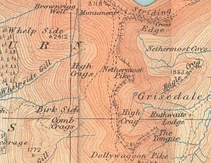 The Helvellyn range
runs broadly north-south for about 11 kilometres (6.8 mi), remaining above 600 m (1,970 ft) throughout its length. Nethermost Pike is toward the southern end of this ridge, with Helvellyn
itself to the north and Dollywaggon Pike
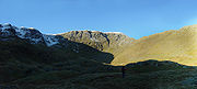
to the south. In common with much of the Helvellyn range there is a marked contrast between the western and eastern slopes of Nethermost Pike. In Wainwright's words: "The grassy western slope trodden by the multitudes is of little interest, but the fell should not be judged accordingly: it is made of sterner stuff. From the east, Nethermost Pike is magnificent, hardly less so than Helvellyn."
The western slopes fall smoothly to the head of Thirlmere reservoir, and the tiny church at Wythburn. There are rougher areas, High and Comb Crags in particular, but these do little to change the overall impression of high moorland. The lower slopes have been planted with conifers as part of the Thirlmere Forest, but above this is a sense of wide open space. Nethermost Pike's toehold on the valley is shifted a little to the south, relative to its position on the ridge. This is because Whelpside and Birkside Gills, its boundary streams, both run south-west, rather than flowing straight down the slope.
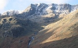
 On the east, the first impression is all of rock. The long strath
of Grisedale runs north eastward to Ullswater, cutting off a series of hanging valleys which fall from the Helvellyn range. To the south east of Nethermost Pike, below the summit of High Crag, is Ruthwaite Cove. Surrounded by crag on three sides, this corrie
contains Hard Tarn
, a small pool on a rock shelf. This is one of the most difficult mountain tarns to locate, and its black algal bed and clear water combine to give the false impression of great depth. Ruthwaite Cove is now the site of Ruthwaite Lodge, a climbing hut. It was formerly the setting for more industrial activity, with the remains of several underground mines
and some shallow open workings
visible near the Lodge.
Between Ruthwaite and Nethermost Coves, Nethermost Pike sends out a fine rocky ridge. This arête
, although not as imposing as Striding Edge across Nethermost Cove, ascends by a series of rocky steps for three quarters of a mile, making straight for the summit. It is from this angle, rather than from the west, that the fell earns the sobriquet of "Pike", meaning peaked mountain. At the bottom of the ridge is Eagle Crag, standing above Grisedale Beck and forcing walkers to take a detour from the ridgeline.
 North from Nethermost Pike is the depression of Swallow Scarth, above the head of Nethermost Cove. From here the ridge climbs again, turning to the west as the long plateau of Helvellyn top is reached. Southwards the ridge steps down over High Crag, and narrows as it swings east around Ruthwaite Cove to Dollywaggon Pike. A heavily eroded path runs along the ridge, but actually bypasses the top of Nethermost Pike to the west, as it leads to Helvellyn.
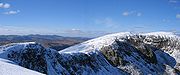
The summit area is triangular in plan with ridges running to the north, south and east. The actual top is toward the northern corner and set back a little from the drop to Nethermost Cove. There is a rash of stones on the summit although the surroundings are mostly covered in rough grass, and several small cairn
s have been built. Other than northward, where the bulk of Helvellyn intervenes, the view is extensive, with much of the Lake District visible. Further ground is brought into view from the summit of High Crag.
and Patterdale
, 8 kilometres (5 mi) to the east, close to the shores of Ullswater
. Both are common starting points for climbing Nethermost Pike or other fells in the Helvellyn range. The best ascents from the east is the east ridge, reached either from the path to Eagle Crag Mine, or via Ruthwaite Lodge and Hard Tarn. There are no settlements of note close to Nethermost Pike to the west, and many walkers start from a car park at Wythburn, close to Wythburn Church. This is a popular route which follows a wide track to Helvellyn before branching off right at Swallow Scarth. Alternatives are possible on the smooth flanks of the fell, but all are pathless.
Because of its close proximity to the higher Helvellyn, Nethermost Pike receives fewer visitors. When climbing from the west many people traverse the western slopes on their way to Helvellyn. Despite this the summit does still receive a large number of walkers, who use a large number of footpaths. The large number of footpaths causes significant disturbance to the summit vegetation, which could be greatly reduced by using fewer footpaths.
-tuff
of the Helvellyn Formation. The geology of much of the Lake District is the Borrowdale Volcanic Group, of which Nethermost Pike is part, and is late Ordovician
in age. The eastern cliffs of the range, including those of Nethermost Pike, are rich in base minerals. When these rocks weather
they form areas of fertile soil, which together with the area's inaccessibility and climate provide suitable conditions for plants of biological importance.
Mining was carried out in Ruthwaite Cove, and the remains of several levels and some shallow open workings are visible near Ruthwaite Lodge. These excavations were made in a search for lead-bearing galena
, and are believed to have been worked in the 16th century. Further leases were taken out in 1784 and 1862; the last known operation was in 1880.
North east of the summit the scene is repeated in Nethermost Cove, where the Eagle Crag Mine was mined for its lead and zinc
. The vein
which was exploited forms a visible gully on Eagle Crag, and was worked both above and below ground over an altitude of 300 metres (984.3 ft). The vein is surrounded by rocks from the Borrowdale Volcanic Group, which dates from the Ordovician
. Large dumps of veinstone are found in the area as a result of the mining. They contain, among other minerals, crystallised tetrahedrite
, which is not believed to be able to be seen or collected anywhere else in Britain. Eagle Crag Mine has a history of working similar to that of Ruthwaite Lodge.
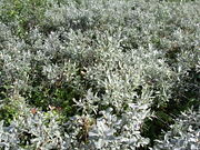 The summit and surrounding areas of Nethermost Pike contain many species and communities which are of biological interest. North east of the summit is Nethermost Cove which contains some of England's best arctic-alpine
and tall-herb vegetation, including one third of the English population of Downy Willow (Salix lapponum). Similarly Ruthwaite Cove contains Arctic-alpine and tall-herb communities, and it is believed that the cove may contain very rare species of plants in very small, and therefore precarious, populations. The lower eastern slopes form Grisedale Common, a large expanse of dwarf shrub heath. The lower slopes are grazed by sheep, which has a significant effect on the type of vegetation which grows. Certain areas, such as Eagle Crag, are inaccessible to sheep due to their steep slopes.
The summit and eastern slopes of Nethermost Pike are part of the Helvellyn and Fairfield Site of Special Scientific Interest
(SSSI). This SSSI covers 2418.8 hectares (5,977 acre) centred on the Helvellyn range and Fairfield, and was designated in 1975 because of the area's geological and biological features. Natural England
, which is responsible for choosing SSSIs, tries to ensure that the management and use of the area is sustainable.
Overgrazing by sheep in Grisedale Common has damaged the vegetation to the extent that it has needed careful management. Since 2003 grazing has been limited to one ewe
per hectare (2.5 acres) in summer and 0.6 ewe in winter. In summer sheep are also flushed from the coves, (Nethermost and Ruthwaite) as they contain vegetation which is susceptible to damage from summer grazing. The vegetation structure has started to improve, however recovery is slowest on the higher land and the summit is still heavily grazed. The summit suffers erosion from the large number of walkers who climb Nethermost Pike. The use of fewer footpaths would help reduce the disturbance to the summit species.
Fell
“Fell” is a word used to refer to mountains, or certain types of mountainous landscape, in Scandinavia, the Isle of Man, and parts of northern England.- Etymology :...
in Cumbria
Cumbria
Cumbria , is a non-metropolitan county in North West England. The county and Cumbria County Council, its local authority, came into existence in 1974 after the passage of the Local Government Act 1972. Cumbria's largest settlement and county town is Carlisle. It consists of six districts, and in...
, England, and a part of the Lake District
Lake District
The Lake District, also commonly known as The Lakes or Lakeland, is a mountainous region in North West England. A popular holiday destination, it is famous not only for its lakes and its mountains but also for its associations with the early 19th century poetry and writings of William Wordsworth...
. At 891 metres (2,923 ft) it is the second highest Wainwright in the Helvellyn range
Helvellyn range
Helvellyn range is the name given to a part of the Eastern Fells in the English Lake District, fell being the local word for hill. The name comes from Helvellyn, the highest point of the group....
, the tallest of which is Helvellyn
Helvellyn
Helvellyn is a mountain in the English Lake District, the apex of the Eastern Fells. At above sea level, it is the third highest peak in both the Lake District and England...
itself. It is located close to the southern end of the ridge, with Helvellyn to the north, and High Crag and Dollywaggon Pike
Dollywaggon Pike
Dollywaggon Pike is a fell in the English Lake District. It stands on the main spine of the Helvellyn range in the Eastern Fells, between Thirlmere and the Ullswater catchment.-Name:...
to the south. Nethermost Pike, along with many of the Eastern Fells
Eastern Fells
The Eastern Fells are a group of hills in the English Lake District. Centred on Helvellyn they primarily comprise a north south ridge running between Ullswater and Lakeland's Central Valley.-Partition of the Lakeland Fells:...
, lies between Thirlmere
Thirlmere
Thirlmere is a reservoir in the Borough of Allerdale in Cumbria and the English Lake District. It runs roughly south to north, with a dam at the northern end, and is bordered on the eastern side by the A591 road and on the western side by a minor road....
in the west and the Ullswater
Ullswater
Ullswater is the second largest lake in the English Lake District, being approximately nine miles long and 0.75 miles wide with a maximum depth of slightly more than ....
catchment
Drainage basin
A drainage basin is an extent or an area of land where surface water from rain and melting snow or ice converges to a single point, usually the exit of the basin, where the waters join another waterbody, such as a river, lake, reservoir, estuary, wetland, sea, or ocean...
in the east. The closest villages are Glenridding
Glenridding
Glenridding is a village located at the southern end of Ullswater, in the English Lake District. The village is popular with mountain walkers who can scale England's third highest mountain, Helvellyn, and many other challenging peaks from here. The village has ample accommodation including two...
and Patterdale
Patterdale
Patterdale is a small village and civil parish in the eastern part of the English Lake District in the Eden District of Cumbria, and the long valley in which they are found, also called the Ullswater Valley....
on the shores of Ullswater, over 8 kilometres (5 mi) away.
Like most fells in the Helvellyn range, Nethermost Pike has grassy western slopes and rocky outcrops on the eastern side. Geologically, Nethermost Pike belongs to the Borrowdale Volcanic Group. Lead
Lead
Lead is a main-group element in the carbon group with the symbol Pb and atomic number 82. Lead is a soft, malleable poor metal. It is also counted as one of the heavy metals. Metallic lead has a bluish-white color after being freshly cut, but it soon tarnishes to a dull grayish color when exposed...
was once mined on its eastern slopes, resulting in open workings
Open-pit mining
Open-pit mining or opencast mining refers to a method of extracting rock or minerals from the earth by their removal from an open pit or borrow....
and underground mines
Shaft mining
Shaft mining or shaft sinking refers to the method of excavating a vertical or near-vertical tunnel from the top down, where there is initially no access to the bottom....
. The eastern slopes are protected as part of a Site of Special Scientific Interest
Site of Special Scientific Interest
A Site of Special Scientific Interest is a conservation designation denoting a protected area in the United Kingdom. SSSIs are the basic building block of site-based nature conservation legislation and most other legal nature/geological conservation designations in Great Britain are based upon...
because of the Pike's geological and biological features, which include some of England's best arctic-alpine
Tundra
In physical geography, tundra is a biome where the tree growth is hindered by low temperatures and short growing seasons. The term tundra comes through Russian тундра from the Kildin Sami word tūndâr "uplands," "treeless mountain tract." There are three types of tundra: Arctic tundra, alpine...
and tall-herb vegetation.
Classification
Mountains are often classifiedHill lists in the British Isles
The mountains and hills of Great Britain, and to a lesser extent Ireland, are the subject of a considerable number of lists that categorise them by height, topographic prominence, or other criteria. They are commonly used as a basis for peak bagging, whereby hillwalkers attempt to reach all the...
according to their heights. At 891 m (2,922 ft) Nethermost Pike is listed as a Nuttall, which requires an altitude of 610 m (2,000 ft). However with a prominence of 22 metres (72 ft) it is not counted as a Hewitt or Marilyn
Marilyn (hill)
A Marilyn is a mountain or hill in the United Kingdom, Republic of Ireland or Isle of Man with a relative height of at least 150 metres , regardless of absolute height or other merit...
which require prominences of 30 metres (98 ft) and 150 metres (492 ft) respectively. Nethermost Pike is also counted as a Wainwright because it was given a chapter in Alfred Wainwright
Alfred Wainwright
Alfred Wainwright MBE was a British fellwalker, guidebook author and illustrator. His seven-volume Pictorial Guide to the Lakeland Fells, published between 1955 and 1966 and consisting entirely of reproductions of his manuscript, has become the standard reference work to 214 of the fells of the...
's Pictorial Guide to the Lakeland Fells
Pictorial Guide to the Lakeland Fells
A Pictorial Guide to the Lakeland Fells is a series of seven books by A. Wainwright, detailing the fells of the Lake District in northwest England...
. It is the second highest of the Eastern Fells
Eastern Fells
The Eastern Fells are a group of hills in the English Lake District. Centred on Helvellyn they primarily comprise a north south ridge running between Ullswater and Lakeland's Central Valley.-Partition of the Lakeland Fells:...
, and the ninth highest of all the Wainwrights. South of Nethermost Pike is High Crag 884 metres (2,900 ft), which is separated from Nethermost Pike by a very limited depression. Most guidebooks follow Alfred Wainwright in considering High Crag to be a part of Nethermost Pike. This convention is not universally followed however, with author Bill Birkett preferring to differentiate between the two fells.
Topography
Helvellyn range
Helvellyn range is the name given to a part of the Eastern Fells in the English Lake District, fell being the local word for hill. The name comes from Helvellyn, the highest point of the group....
runs broadly north-south for about 11 kilometres (6.8 mi), remaining above 600 m (1,970 ft) throughout its length. Nethermost Pike is toward the southern end of this ridge, with Helvellyn
Helvellyn
Helvellyn is a mountain in the English Lake District, the apex of the Eastern Fells. At above sea level, it is the third highest peak in both the Lake District and England...
itself to the north and Dollywaggon Pike
Dollywaggon Pike
Dollywaggon Pike is a fell in the English Lake District. It stands on the main spine of the Helvellyn range in the Eastern Fells, between Thirlmere and the Ullswater catchment.-Name:...
to the south. In common with much of the Helvellyn range there is a marked contrast between the western and eastern slopes of Nethermost Pike. In Wainwright's words: "The grassy western slope trodden by the multitudes is of little interest, but the fell should not be judged accordingly: it is made of sterner stuff. From the east, Nethermost Pike is magnificent, hardly less so than Helvellyn."
The western slopes fall smoothly to the head of Thirlmere reservoir, and the tiny church at Wythburn. There are rougher areas, High and Comb Crags in particular, but these do little to change the overall impression of high moorland. The lower slopes have been planted with conifers as part of the Thirlmere Forest, but above this is a sense of wide open space. Nethermost Pike's toehold on the valley is shifted a little to the south, relative to its position on the ridge. This is because Whelpside and Birkside Gills, its boundary streams, both run south-west, rather than flowing straight down the slope.
Strath
A strath is a large valley, typically a river valley that is wide and shallow .An anglicisation of the Gaelic word srath, it is one of many that have been absorbed into common use in the English language...
of Grisedale runs north eastward to Ullswater, cutting off a series of hanging valleys which fall from the Helvellyn range. To the south east of Nethermost Pike, below the summit of High Crag, is Ruthwaite Cove. Surrounded by crag on three sides, this corrie
Cirque
Cirque may refer to:* Cirque, a geological formation* Makhtesh, an erosional landform found in the Negev desert of Israel and Sinai of Egypt*Cirque , an album by Biosphere* Cirque Corporation, a company that makes touchpads...
contains Hard Tarn
Tarn (lake)
A tarn is a mountain lake or pool, formed in a cirque excavated by a glacier. A moraine may form a natural dam below a tarn. A corrie may be called a cirque.The word is derived from the Old Norse word tjörn meaning pond...
, a small pool on a rock shelf. This is one of the most difficult mountain tarns to locate, and its black algal bed and clear water combine to give the false impression of great depth. Ruthwaite Cove is now the site of Ruthwaite Lodge, a climbing hut. It was formerly the setting for more industrial activity, with the remains of several underground mines
Shaft mining
Shaft mining or shaft sinking refers to the method of excavating a vertical or near-vertical tunnel from the top down, where there is initially no access to the bottom....
and some shallow open workings
Open-pit mining
Open-pit mining or opencast mining refers to a method of extracting rock or minerals from the earth by their removal from an open pit or borrow....
visible near the Lodge.
Between Ruthwaite and Nethermost Coves, Nethermost Pike sends out a fine rocky ridge. This arête
Arete
Areté is the term meaning "virtue" or "excellence", from Greek ἈρετήArete may also be used:*as a given name of persons or things:**Queen Arete , a character in Homer's Odyssey.***197 Arete, an asteroid....
, although not as imposing as Striding Edge across Nethermost Cove, ascends by a series of rocky steps for three quarters of a mile, making straight for the summit. It is from this angle, rather than from the west, that the fell earns the sobriquet of "Pike", meaning peaked mountain. At the bottom of the ridge is Eagle Crag, standing above Grisedale Beck and forcing walkers to take a detour from the ridgeline.
The summit area is triangular in plan with ridges running to the north, south and east. The actual top is toward the northern corner and set back a little from the drop to Nethermost Cove. There is a rash of stones on the summit although the surroundings are mostly covered in rough grass, and several small cairn
Cairn
Cairn is a term used mainly in the English-speaking world for a man-made pile of stones. It comes from the or . Cairns are found all over the world in uplands, on moorland, on mountaintops, near waterways and on sea cliffs, and also in barren desert and tundra areas...
s have been built. Other than northward, where the bulk of Helvellyn intervenes, the view is extensive, with much of the Lake District visible. Further ground is brought into view from the summit of High Crag.
Ascents and tourism
The Lake District receives over 12 million visitors a year, many of whom come to climb the mountains. The closest villages to Nethermost pike are GlenriddingGlenridding
Glenridding is a village located at the southern end of Ullswater, in the English Lake District. The village is popular with mountain walkers who can scale England's third highest mountain, Helvellyn, and many other challenging peaks from here. The village has ample accommodation including two...
and Patterdale
Patterdale
Patterdale is a small village and civil parish in the eastern part of the English Lake District in the Eden District of Cumbria, and the long valley in which they are found, also called the Ullswater Valley....
, 8 kilometres (5 mi) to the east, close to the shores of Ullswater
Ullswater
Ullswater is the second largest lake in the English Lake District, being approximately nine miles long and 0.75 miles wide with a maximum depth of slightly more than ....
. Both are common starting points for climbing Nethermost Pike or other fells in the Helvellyn range. The best ascents from the east is the east ridge, reached either from the path to Eagle Crag Mine, or via Ruthwaite Lodge and Hard Tarn. There are no settlements of note close to Nethermost Pike to the west, and many walkers start from a car park at Wythburn, close to Wythburn Church. This is a popular route which follows a wide track to Helvellyn before branching off right at Swallow Scarth. Alternatives are possible on the smooth flanks of the fell, but all are pathless.
Because of its close proximity to the higher Helvellyn, Nethermost Pike receives fewer visitors. When climbing from the west many people traverse the western slopes on their way to Helvellyn. Despite this the summit does still receive a large number of walkers, who use a large number of footpaths. The large number of footpaths causes significant disturbance to the summit vegetation, which could be greatly reduced by using fewer footpaths.
Geology and mining
Geologically the summit of the fell forms part of the Deepdale Formation, (principally volcaniclastic sandstone) underlain by the dacitic lapilliLapilli
Lapilli is a size classification term for tephra, which is material that falls out of the air during a volcanic eruption or during some meteorite impacts. Lapilli means "little stones" in Latin. They are in some senses similar to ooids or pisoids in calcareous sediments.By definition lapilli range...
-tuff
Tuff
Tuff is a type of rock consisting of consolidated volcanic ash ejected from vents during a volcanic eruption. Tuff is sometimes called tufa, particularly when used as construction material, although tufa also refers to a quite different rock. Rock that contains greater than 50% tuff is considered...
of the Helvellyn Formation. The geology of much of the Lake District is the Borrowdale Volcanic Group, of which Nethermost Pike is part, and is late Ordovician
Ordovician
The Ordovician is a geologic period and system, the second of six of the Paleozoic Era, and covers the time between 488.3±1.7 to 443.7±1.5 million years ago . It follows the Cambrian Period and is followed by the Silurian Period...
in age. The eastern cliffs of the range, including those of Nethermost Pike, are rich in base minerals. When these rocks weather
Erosion
Erosion is when materials are removed from the surface and changed into something else. It only works by hydraulic actions and transport of solids in the natural environment, and leads to the deposition of these materials elsewhere...
they form areas of fertile soil, which together with the area's inaccessibility and climate provide suitable conditions for plants of biological importance.
Mining was carried out in Ruthwaite Cove, and the remains of several levels and some shallow open workings are visible near Ruthwaite Lodge. These excavations were made in a search for lead-bearing galena
Galena
Galena is the natural mineral form of lead sulfide. It is the most important lead ore mineral.Galena is one of the most abundant and widely distributed sulfide minerals. It crystallizes in the cubic crystal system often showing octahedral forms...
, and are believed to have been worked in the 16th century. Further leases were taken out in 1784 and 1862; the last known operation was in 1880.
North east of the summit the scene is repeated in Nethermost Cove, where the Eagle Crag Mine was mined for its lead and zinc
Zinc
Zinc , or spelter , is a metallic chemical element; it has the symbol Zn and atomic number 30. It is the first element in group 12 of the periodic table. Zinc is, in some respects, chemically similar to magnesium, because its ion is of similar size and its only common oxidation state is +2...
. The vein
Vein (geology)
In geology, a vein is a distinct sheetlike body of crystallized minerals within a rock. Veins form when mineral constituents carried by an aqueous solution within the rock mass are deposited through precipitation...
which was exploited forms a visible gully on Eagle Crag, and was worked both above and below ground over an altitude of 300 metres (984.3 ft). The vein is surrounded by rocks from the Borrowdale Volcanic Group, which dates from the Ordovician
Ordovician
The Ordovician is a geologic period and system, the second of six of the Paleozoic Era, and covers the time between 488.3±1.7 to 443.7±1.5 million years ago . It follows the Cambrian Period and is followed by the Silurian Period...
. Large dumps of veinstone are found in the area as a result of the mining. They contain, among other minerals, crystallised tetrahedrite
Tetrahedrite
Tetrahedrite is a copper antimony sulfosalt mineral with formula: 12Sb4S13. It is the antimony endmember of the continuous solid solution series with arsenic bearing tennantite. Pure endmembers of the series are seldom if ever seen in nature. Of the two, the antimony rich phase is more common...
, which is not believed to be able to be seen or collected anywhere else in Britain. Eagle Crag Mine has a history of working similar to that of Ruthwaite Lodge.
Biological interest
Tundra
In physical geography, tundra is a biome where the tree growth is hindered by low temperatures and short growing seasons. The term tundra comes through Russian тундра from the Kildin Sami word tūndâr "uplands," "treeless mountain tract." There are three types of tundra: Arctic tundra, alpine...
and tall-herb vegetation, including one third of the English population of Downy Willow (Salix lapponum). Similarly Ruthwaite Cove contains Arctic-alpine and tall-herb communities, and it is believed that the cove may contain very rare species of plants in very small, and therefore precarious, populations. The lower eastern slopes form Grisedale Common, a large expanse of dwarf shrub heath. The lower slopes are grazed by sheep, which has a significant effect on the type of vegetation which grows. Certain areas, such as Eagle Crag, are inaccessible to sheep due to their steep slopes.
The summit and eastern slopes of Nethermost Pike are part of the Helvellyn and Fairfield Site of Special Scientific Interest
Site of Special Scientific Interest
A Site of Special Scientific Interest is a conservation designation denoting a protected area in the United Kingdom. SSSIs are the basic building block of site-based nature conservation legislation and most other legal nature/geological conservation designations in Great Britain are based upon...
(SSSI). This SSSI covers 2418.8 hectares (5,977 acre) centred on the Helvellyn range and Fairfield, and was designated in 1975 because of the area's geological and biological features. Natural England
Natural England
Natural England is the non-departmental public body of the UK government responsible for ensuring that England's natural environment, including its land, flora and fauna, freshwater and marine environments, geology and soils, are protected and improved...
, which is responsible for choosing SSSIs, tries to ensure that the management and use of the area is sustainable.
Overgrazing by sheep in Grisedale Common has damaged the vegetation to the extent that it has needed careful management. Since 2003 grazing has been limited to one ewe
Domestic sheep
Sheep are quadrupedal, ruminant mammals typically kept as livestock. Like all ruminants, sheep are members of the order Artiodactyla, the even-toed ungulates. Although the name "sheep" applies to many species in the genus Ovis, in everyday usage it almost always refers to Ovis aries...
per hectare (2.5 acres) in summer and 0.6 ewe in winter. In summer sheep are also flushed from the coves, (Nethermost and Ruthwaite) as they contain vegetation which is susceptible to damage from summer grazing. The vegetation structure has started to improve, however recovery is slowest on the higher land and the summit is still heavily grazed. The summit suffers erosion from the large number of walkers who climb Nethermost Pike. The use of fewer footpaths would help reduce the disturbance to the summit species.