
Great End
Encyclopedia
Great End is the most northerly mountain
in the Scafell
chain, in the English
Lake District
. From the south it is simply a lump continuing this chain.
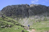
From the north, however, it is appears as an immense mountain, with an imposing north face rising above Sprinkling Tarn
(lake). This is a popular location for wild camping, and the north face attracts many climbers
.
Alfred Wainwright
wrote of Great End in his Pictorial Guide to the Lakeland Fells
:
"This is the true Lakeland of the fellwalker, the sort of terrain that calls him back time after time, the sort of memory that haunts his long winter exile. It is not the pretty places - the flowery lanes of Grasmere
or Derwentwater's wooded bays - that keep him restless in his bed; it is the magnificent ones. Places like Great End..."
, replete with numerous tarns
.. The largest is Sprinkling Tarn with its beautifully indented shoreline providing perfect foreground for views of the cliff.
Sty Head is one of the focal points of the District for walkers. The name strictly applies to the col between Great End and Great Gable
at a height of 1,560 ft, but is now more generally given to the path which crosses it. This connects two of the most popular starting points for walks in the high fells, Wasdale Head and Seathwaite. Sty Head is also a walker's crossroads with other paths leading direct up Great Gable and following the outflow of Sprinkling Tarn
up to Esk Hause.
Westward from the summit Great End makes a rocky descent toward the arms of Lingmell Beck. This flank is crossed by the Corridor Route, the popular path to Scafell Pike
from Sty Head. Above the path are the subsidiary top of Round How (a Nuttall) and the tiny, beautifully clear tarn of Lambfoot Dub.
The southward ridge to the Scafells
crosses a shallow saddle and then climbs over Ill Crag and Broad Crag, a well blazoned path leading across the stony terrain to the summit of Scafell Pike. To the east of the first depression is Calf Cove, its easy slopes leading down to Esk Hause.
The summit has two cairns of very similar height, that to the north west being nearer to the cliff edge and having the better view. Northwards along Borrowdale
the vista is unsurpassed, but the whole panorama is excellent. The heads of the gullies can also be approached for startling views down the face.
and siltstone
of the Esk Pike Formation overlying the dacitic
welded lapilli
-tuff
of the Lincomb Tarns Formation. The latter is revealed in the great north front.
), from Wasdale Head
along Lingmell Gill and Spouthead Gill, from Borrowdale
via Grains Gill, from Great Langdale via Rossett Gill and Esk Hause
, or from Eskdale
. As an intermediate objective Great End may easily be climbed from the main path between Esk Hause
and Scafell Pike
, requiring only a detour of some 400 m.
and Mont Blanc
. Cust's Gully is a Grade 1 rock climb, but a difficult obstacle for walkers ascending from Sprinkling Tarn
. Cust's first winter ascent of the gully was recorded in 1880, although he is thought to have ascended it earlier.
Mountain
Image:Himalaya_annotated.jpg|thumb|right|The Himalayan mountain range with Mount Everestrect 58 14 160 49 Chomo Lonzorect 200 28 335 52 Makalurect 378 24 566 45 Mount Everestrect 188 581 920 656 Tibetan Plateaurect 250 406 340 427 Rong River...
in the Scafell
Sca Fell
Sca Fell is a mountain in the English Lake District. Its height of 964 metres makes it the second-highest mountain in England after Scafell Pike, from which it is separated by the col of Mickledore....
chain, in the English
England
England is a country that is part of the United Kingdom. It shares land borders with Scotland to the north and Wales to the west; the Irish Sea is to the north west, the Celtic Sea to the south west, with the North Sea to the east and the English Channel to the south separating it from continental...
Lake District
Lake District
The Lake District, also commonly known as The Lakes or Lakeland, is a mountainous region in North West England. A popular holiday destination, it is famous not only for its lakes and its mountains but also for its associations with the early 19th century poetry and writings of William Wordsworth...
. From the south it is simply a lump continuing this chain.
From the north, however, it is appears as an immense mountain, with an imposing north face rising above Sprinkling Tarn
Sprinkling Tarn
Sprinkling Tarn is a body of water at the foot of Great End, in the Southern Fells in Lake District, 3 km from Seathwaite, Cumbria. Sprinkling Tarn is a popular location for wild campers. It is also popular among anglers, being noted for its trout and vendace. Formerly known also as Sparkling...
(lake). This is a popular location for wild camping, and the north face attracts many climbers
Climbing
Climbing is the activity of using one's hands and feet to ascend a steep object. It is done both for recreation and professionally, as part of activities such as maintenance of a structure, or military operations.Climbing activities include:* Bouldering: Ascending boulders or small...
.
Alfred Wainwright
Alfred Wainwright
Alfred Wainwright MBE was a British fellwalker, guidebook author and illustrator. His seven-volume Pictorial Guide to the Lakeland Fells, published between 1955 and 1966 and consisting entirely of reproductions of his manuscript, has become the standard reference work to 214 of the fells of the...
wrote of Great End in his Pictorial Guide to the Lakeland Fells
Pictorial Guide to the Lakeland Fells
A Pictorial Guide to the Lakeland Fells is a series of seven books by A. Wainwright, detailing the fells of the Lake District in northwest England...
:
"This is the true Lakeland of the fellwalker, the sort of terrain that calls him back time after time, the sort of memory that haunts his long winter exile. It is not the pretty places - the flowery lanes of Grasmere
Grasmere
Grasmere is a village, and popular tourist destination, in the centre of the English Lake District. It takes its name from the adjacent lake, and is associated with the Lake Poets...
or Derwentwater's wooded bays - that keep him restless in his bed; it is the magnificent ones. Places like Great End..."
Topography
The imposing north eastern cliffs, riven by gullies, rise some 600 ft from the Esk Hause path. Their orientation ensures that the sun rarely reaches them, the gullies often retaining snow well into the spring. From the left when viewed from below the principal fissures are South East Gully, Central Gully and Cust's Gully (see below). To the west of the cliffs a ridge descends more gradually in the general direction of Sty Head. This is known as The Band, and it too sports a harsh gash across its features. On the western side of The Band is the deep ravine of Skew Gill, a tributary of Wasdale-bound Lingmell Beck. At the base of The Band the ridge continues as the complex top of Seathwaite FellSeathwaite Fell
Seathwaite Fell is an area of the Lake District in Cumbria, England. It stands above the hamlet of the same name at the head of Borrowdale.-Position of the summit:...
, replete with numerous tarns
Tarn (lake)
A tarn is a mountain lake or pool, formed in a cirque excavated by a glacier. A moraine may form a natural dam below a tarn. A corrie may be called a cirque.The word is derived from the Old Norse word tjörn meaning pond...
.. The largest is Sprinkling Tarn with its beautifully indented shoreline providing perfect foreground for views of the cliff.
Sty Head is one of the focal points of the District for walkers. The name strictly applies to the col between Great End and Great Gable
Great Gable
Great Gable is a mountain lying at the very heart of the English Lake District, appearing as a pyramid from Wasdale , but as a dome from most other directions. It is one of the most popular of the Lakeland fells, and there are many different routes to the summit...
at a height of 1,560 ft, but is now more generally given to the path which crosses it. This connects two of the most popular starting points for walks in the high fells, Wasdale Head and Seathwaite. Sty Head is also a walker's crossroads with other paths leading direct up Great Gable and following the outflow of Sprinkling Tarn
Sprinkling Tarn
Sprinkling Tarn is a body of water at the foot of Great End, in the Southern Fells in Lake District, 3 km from Seathwaite, Cumbria. Sprinkling Tarn is a popular location for wild campers. It is also popular among anglers, being noted for its trout and vendace. Formerly known also as Sparkling...
up to Esk Hause.
Westward from the summit Great End makes a rocky descent toward the arms of Lingmell Beck. This flank is crossed by the Corridor Route, the popular path to Scafell Pike
Scafell Pike
Scafell Pike is the highest mountain in England at . It is located in Lake District National Park sometimes confused with the neighbouring Sca Fell, to which it is connected by the col of Mickledore...
from Sty Head. Above the path are the subsidiary top of Round How (a Nuttall) and the tiny, beautifully clear tarn of Lambfoot Dub.
The southward ridge to the Scafells
Scafells
Image:Annotated Scafell range.jpg|thumb|right|300px|The Scafell range as seen looking west from Crinkle Crags. rect 23 372 252 419 Slight Side rect 173 794 560 834 Scafell East Buttress...
crosses a shallow saddle and then climbs over Ill Crag and Broad Crag, a well blazoned path leading across the stony terrain to the summit of Scafell Pike. To the east of the first depression is Calf Cove, its easy slopes leading down to Esk Hause.
The summit has two cairns of very similar height, that to the north west being nearer to the cliff edge and having the better view. Northwards along Borrowdale
Borrowdale
Borrowdale is a valley and civil parish in the English Lake District in the Borough of Allerdale in Cumbria, England.Borrowdale lies within the historic county boundaries of Cumberland, and is sometimes referred to as Cumberland Borrowdale in order to distinguish it from another Borrowdale in the...
the vista is unsurpassed, but the whole panorama is excellent. The heads of the gullies can also be approached for startling views down the face.
Geology
The summit is formed by the laminated volcaniclastic claystoneClaystone
Claystone is a geological term used to describe a clastic sedimentary rock that is composed primarily of clay-sized particles ....
and siltstone
Siltstone
Siltstone is a sedimentary rock which has a grain size in the silt range, finer than sandstone and coarser than claystones.- Description :As its name implies, it is primarily composed of silt sized particles, defined as grains 1/16 - 1/256 mm or 4 to 8 on the Krumbein phi scale...
of the Esk Pike Formation overlying the dacitic
Dacite
Dacite is an igneous, volcanic rock. It has an aphanitic to porphyritic texture and is intermediate in composition between andesite and rhyolite. The relative proportions of feldspars and quartz in dacite, and in many other volcanic rocks, are illustrated in the QAPF diagram...
welded lapilli
Lapilli
Lapilli is a size classification term for tephra, which is material that falls out of the air during a volcanic eruption or during some meteorite impacts. Lapilli means "little stones" in Latin. They are in some senses similar to ooids or pisoids in calcareous sediments.By definition lapilli range...
-tuff
Tuff
Tuff is a type of rock consisting of consolidated volcanic ash ejected from vents during a volcanic eruption. Tuff is sometimes called tufa, particularly when used as construction material, although tufa also refers to a quite different rock. Rock that contains greater than 50% tuff is considered...
of the Lincomb Tarns Formation. The latter is revealed in the great north front.
Ascents
Great End may be ascended from Sty Head Tarn via The Band (not to be confused with the more famous Band on BowfellBowfell
Bowfell is a pyramid-shaped mountain lying at the heart of the English Lake District, in the Southern Fells area. It is the sixth highest mountain in the lakes and one of the most popular of the Lake District fells...
), from Wasdale Head
Wasdale Head
Wasdale Head is a small agricultural village in the Lake District National Park in Cumbria, England. The village claims to be home of the highest mountain , deepest lake , smallest church and biggest liar in England...
along Lingmell Gill and Spouthead Gill, from Borrowdale
Borrowdale
Borrowdale is a valley and civil parish in the English Lake District in the Borough of Allerdale in Cumbria, England.Borrowdale lies within the historic county boundaries of Cumberland, and is sometimes referred to as Cumberland Borrowdale in order to distinguish it from another Borrowdale in the...
via Grains Gill, from Great Langdale via Rossett Gill and Esk Hause
Esk Hause
Esk Hause is a mountain pass in the English Lake District, where paths from Eskdale, Borrowdale, Langdale and Wasdale all meet. Esk Hause is a first step to reaching higher summits, such as Scafell Pike, Great End, Esk Pike and Allen Crags, which are all nearby.The source of the River Esk is close...
, or from Eskdale
Eskdale, Cumbria
Eskdale is a glacial valley and civil parish in the western Lake District National Park in Cumbria, England. It forms part of the Borough of Copeland, and has a population of 264....
. As an intermediate objective Great End may easily be climbed from the main path between Esk Hause
Esk Hause
Esk Hause is a mountain pass in the English Lake District, where paths from Eskdale, Borrowdale, Langdale and Wasdale all meet. Esk Hause is a first step to reaching higher summits, such as Scafell Pike, Great End, Esk Pike and Allen Crags, which are all nearby.The source of the River Esk is close...
and Scafell Pike
Scafell Pike
Scafell Pike is the highest mountain in England at . It is located in Lake District National Park sometimes confused with the neighbouring Sca Fell, to which it is connected by the col of Mickledore...
, requiring only a detour of some 400 m.
Cust's Gully
Cust's Gully at the western end of Great End's cliffs was named after 19th century pioneer climber and sketcher Arthur Cust, a classical scholar from Yorkshire also known for his watercolour sketches of the MatterhornMatterhorn
The Matterhorn , Monte Cervino or Mont Cervin , is a mountain in the Pennine Alps on the border between Switzerland and Italy. Its summit is 4,478 metres high, making it one of the highest peaks in the Alps. The four steep faces, rising above the surrounding glaciers, face the four compass points...
and Mont Blanc
Mont Blanc
Mont Blanc or Monte Bianco , meaning "White Mountain", is the highest mountain in the Alps, Western Europe and the European Union. It rises above sea level and is ranked 11th in the world in topographic prominence...
. Cust's Gully is a Grade 1 rock climb, but a difficult obstacle for walkers ascending from Sprinkling Tarn
Sprinkling Tarn
Sprinkling Tarn is a body of water at the foot of Great End, in the Southern Fells in Lake District, 3 km from Seathwaite, Cumbria. Sprinkling Tarn is a popular location for wild campers. It is also popular among anglers, being noted for its trout and vendace. Formerly known also as Sparkling...
. Cust's first winter ascent of the gully was recorded in 1880, although he is thought to have ascended it earlier.