

Mean center of U.S. population
Encyclopedia
The mean center of U.S. population is determined by the United States Census Bureau
United States Census Bureau
The United States Census Bureau is the government agency that is responsible for the United States Census. It also gathers other national demographic and economic data...
from the results of each census. The Bureau defines it to be:
During the 20th century the mean center of population shifted 324 miles (521 km) west and 101 miles (163 km) south. The southerly movement was much stronger during the second half of the century; 79 miles (127 km) of the 101 miles (163 km) happened between 1950 and 2000.
The following lists location information of the mean center of U.S. population since 1790:
| US Census | County | Location description | decimal Coordinates |
|---|---|---|---|
| 1790 | Kent County, Maryland Kent County, Maryland Kent County is a county located in the U.S. state of Maryland, on its Eastern Shore. It was named for the county of Kent in England. Its county seat is Chestertown. In 2010, the county population was 20,197... 1.) |
23 miles east of Baltimore. | 39.27500°N 76.18667°W |
| 1800 | Howard County, Maryland Howard County, Maryland -2010:Whereas according to the 2010 U.S. Census Bureau:*62.2% White*17.5% Black*0.3% Native American*14.4% Asian*0.0% Native Hawaiian or Pacific Islander*3.6% Two or more races*2.0% Other races*5.8% Hispanic or Latino -2000:... |
18 miles west of Baltimore. | 39.26833°N 76.94167°W |
| 1810 | Loudoun County, Virginia Loudoun County, Virginia Loudoun County is a county located in the Commonwealth of Virginia, and is part of the Washington Metropolitan Area. As of the 2010 U.S. Census, the county is estimated to be home to 312,311 people, an 84 percent increase over the 2000 figure of 169,599. That increase makes the county the fourth... |
40 miles northwest by west of Washington, DC. | 39.19167°N 77.62000°W |
| 1820 | Hardy County, Virginia (now W. Virginia) Hardy County, West Virginia As of the census of 2000, there were 12,669 people, 5,204 households, and 3,564 families residing in the county. The population density was 22 people per square mile . There were 7,115 housing units at an average density of 12 per square mile... 2.) |
16 miles east of Moorefield. | 39.09500°N 78.55000°W |
| 1830 | Grant County, Virginia (now W. Virginia) Grant County, West Virginia As of the census of 2000, there were 11,299 people, 4,591 households, and 3,273 families residing in the county. The population density was 24 people per square mile . There were 6,105 housing units at an average density of 13 per square mile... 2.) |
19 miles west-southwest of Moorefield. | 38.96500°N 79.28167°W |
| 1840 | Upshur County, Virginia (now W. Virginia) Upshur County, West Virginia As of the census of 2000, there were 23,404 people, 8,972 households, and 6,352 families residing in the county. The population density was 66 people per square mile . There were 10,751 housing units at an average density of 30 per square mile... 2.) |
16 miles south of Clarksburg. | 39.03333°N 80.30000°W |
| 1850 | Wirt County, Virginia (now W. Virginia) Wirt County, West Virginia As of the census of 2000, there were 5,873 people, 2,284 households, and 1,699 families residing in the county. The population density was 25 people per square mile . There were 3,266 housing units at an average density of 14 per square mile... 2.) |
23 miles southeast of Parkersburg. | 38.98333°N 81.31667°W |
| 1860 | Pike County, Ohio Pike County, Ohio As of the census of 2000, there were 27,695 people, 10,444 households, and 7,665 families residing in the county. The population density was 63 people per square mile . There were 11,602 housing units at an average density of 26 per square mile... |
20 miles south by east of Chillcothe. | 39.00667°N 82.81333°W |
| 1870 | Highland County, Ohio Highland County, Ohio As of the census of 2000, there were 40,875 people, 15,587 households, and 11,394 families residing in the county. The population density was 74 people per square mile . There were 17,583 housing units at an average density of 32 per square mile... |
48 miles east by north of Cincinnati. | 39.20000°N 83.59500°W |
| 1880 | Boone County, Kentucky Boone County, Kentucky Boone County is a county located in the U.S. state of Kentucky. It was formed in 1798. The population was 118,811 in the 2010 Census. Its county seat is Burlington. The county is named for frontiersman Daniel Boone... |
8 miles west by south of Cincinnati, OH. | 39.06889°N 84.66111°W |
| 1890 | Decatur County, Indiana Decatur County, Indiana As of the census of 2000, there were 24,555 people, 9,389 households, and 6,882 families residing in the county. The population density was 66 people per square mile . There were 9,992 housing units at an average density of 27 per square mile... |
20 miles east of Columbus. | 39.19889°N 85.54806°W |
| 1900 | Bartholomew County, Indiana Bartholomew County, Indiana Bartholomew County is a county located in the U.S. state of Indiana, and determined by the U.S. Census Bureau to include the mean center of U.S. population in 1900. As of 2010, the population was 76,794... |
6 miles southeast of Columbus. | 39.16000°N 85.81500°W |
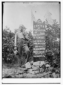
| 1910 | Monroe County, Indiana Monroe County, Indiana As of the census of 2010, there were 137,974 people, 46,898 households, and 24,715 families residing in the county. The population density was 306 people per square mile . There were 50,846 housing units at an average density of 129 per square mile... |
in the city of Bloomington. | 39.17000°N 86.53889°W |
| 1920 | Owen County, Indiana Owen County, Indiana Owen County is a county located in the U.S. state of Indiana, and determined by the U.S. Census Bureau to include the mean center of U.S. population in 1920. As of 2010, the population was 21,575... |
8 miles south-southeast of Spencer. | 39.17250°N 86.72083°W |
| 1930 | Greene County, Indiana Greene County, Indiana Greene County is a county located in the U.S. state of Indiana, and determined by the U.S. Census Bureau to include the mean center of U.S. population in 1930. As of 2010, the population was 33,165. The county seat is Bloomfield.... |
3 miles northeast of Linton. | 39.06250°N 87.13500°W |
| 1940 | Sullivan County, Indiana Sullivan County, Indiana Sullivan County is a county located in the U.S. state of Indiana, and determined by the U.S. Census Bureau to include the mean center of U.S. population in 1940. As of 2010, the population was 21,475. The county seat is Sullivan. Sullivan County is included in the Terre Haute, Indiana,... |
2 miles southeast by east of Carlisle. | 38.94833°N 87.37639°W |
| 1950 | Richland County, Illinois 3.) | 8 miles north-northwest of Olney. 3.) | 38.83917°N 88.15917°W 3.) |
| 1950 | Clay County, Illinois Clay County, Illinois Clay County is a county located in the U.S. state of Illinois. In 1950, the U.S. Census Bureau placed the mean center of U.S. population in Clay County. According to the 2010 census, it has a population of 13,815, which is a decrease of 5.1% from 14,560 in 2000... 4.) |
3 miles northeast of Louisville. 4.) | 38.80417°N 88.36889°W 4.) |
| 1960 | Clinton County, Illinois Clinton County, Illinois -Demographics: As of the census of 2000, there were 35,535 people, 12,754 households, and 9,221 families residing in the county. The population density was 75 people per square mile . There were 13,805 housing units at an average density of 29 per square mile... 5.) |
6-1/2 miles northwest of Centralia. 5.) | 38.59944°N 89.20972°W 5.) |
| 1970 | St. Clair County, Illinois | 5 miles east-southeast of Mascoutah. | 38.46306°N 89.70611°W |
| 1980 | Jefferson County, Missouri Jefferson County, Missouri Jefferson County is a county located in East Central Missouri in the United States. The county was included as the mean center of U.S. population in 1980. It is the sixth most-populous county in Missouri. Census 2010 put the population at 218,733 Its county seat is Hillsboro. The county was... |
1/4 mile west of DeSoto. | 38.13694°N 90.57389°W |
| 1990 | Crawford County, Missouri Crawford County, Missouri -State:In the Missouri House of Representatives, most of Crawford County is included within the 150th Legislative District and is currently represented by State Representative Jason T. Smith . In 2008, Smith defeated Democratic challenger James D. Ellis 69.97-30.03 percent; the Crawford County... |
9.7 miles southeast of Steelville. | 37.87222°N 91.21528°W |
| 2000 | Phelps County, Missouri Phelps County, Missouri Phelps County is a county located in south-central Missouri in the United States.According to the U.S. Census Bureau, it includes the mean center of U.S. population in 2000. As of the 2000 U.S. Census, the county's population was 39,825. A 2008 estimate, however, showed the population to be 42,205.... |
2.8 miles east of Edgar Springs | 37.696987°N 91.809567°W |
| 2010 | Texas County, Missouri Texas County, Missouri Texas County is a county located in South Central Missouri in the United States. As of the 2010 census, the county's population was 26,008. It's county seat is Houston. The county was organized in 1843 as Ashley County, changing its name in 1845 to Texas, after the Republic of Texas. The 2010 U.S... |
2.7 miles northeast of Plato. | 37.517534°N 92.173096°W |
Notes on the table data
- In the first census (1790) the mean population center was near Chestertown, MarylandChestertown, MarylandChestertown is a town in Kent County, Maryland, United States. The population was 4,746 at the 2000 census. It is the county seat of Kent County. The ZIP code is 21620 and the area codes are 410 and 443...
. - The mean population centers of 1820, 1830, 1840 and 1850 were in what is now West VirginiaWest VirginiaWest Virginia is a state in the Appalachian and Southeastern regions of the United States, bordered by Virginia to the southeast, Kentucky to the southwest, Ohio to the northwest, Pennsylvania to the northeast and Maryland to the east...
, given West Virginia's split from VirginiaWheeling ConventionThe 1861 Wheeling Convention was a series of two meetings that ultimately repealed the Ordinance of Secession passed by Virginia, thus establishing the Restored government of Virginia, which ultimately authorized the counties that organized the convention to become West Virginia. The convention was...
in 1863. - Computation method used until 1950
- Current computation method
- The addition of AlaskaAlaskaAlaska is the largest state in the United States by area. It is situated in the northwest extremity of the North American continent, with Canada to the east, the Arctic Ocean to the north, and the Pacific Ocean to the west and south, with Russia further west across the Bering Strait...
and HawaiiHawaiiHawaii is the newest of the 50 U.S. states , and is the only U.S. state made up entirely of islands. It is the northernmost island group in Polynesia, occupying most of an archipelago in the central Pacific Ocean, southwest of the continental United States, southeast of Japan, and northeast of...
to the union moved the center about two miles (3 km) farther south and about ten miles (16 km) farther west in 1960.
See also
- Center of populationCenter of populationIn demographics, the center of population of a region is a geographical point that describes a centerpoint of the region's population...
- Median center of United States populationMedian center of United States populationThe median center of U.S. population is determined by the United States Census Bureau from the results of each census. The Bureau defines it to be:- See also :* Mean center of United States population* Center of population...
- Geographic center of the United StatesGeographic center of the United StatesBefore 1959, the National Geodetic Survey placed the center of the United States at a point near the town of Lebanon, Kansas. When Alaska and Hawaii joined the union in 1959, the NGS designated Belle Fourche , South Dakota, the geographic center of the United States...
- Geographic center of the contiguous United StatesGeographic Center of the Contiguous United StatesOne of the locations claimed to be the Geographic Center of the Contiguous United States is pinpointed by a historical marker that is located within a small park near the town of Lebanon, Kansas. It is located at the intersection of AA Road and K-191, accessible by a turn-off from U.S...