
Indiana State Road 58
Encyclopedia
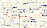
State Road 58 is an east–west road in Central Indiana. State Road 58 runs from Merom
in the west to Columbus
in the east, a distance of approximately 122 miles (196.3 km). Along its route it has concurrencies with one U.S. Route and six other Indiana state roads.
(SR 63) in Merom
. SR 58 heads south and east towards Carlisle
. In Carlisle SR 58 has an intersection
with U.S. Route 41
/U.S. Route 150. SR 58 heads southeast from Carlisle towards Freelandville
. In Freelandville SR 58 has an intersection with the northern terminus of State Road 159
. East of Freelandville SR 58 heads east and has a concurrency
with State Road 67
(SR 67). Then SR 58 heads east towards Elnora
where SR 58 has a concurrency with State Road 57
(SR 57). SR 58 heads south after the concurrency with SR 57. South of Elnora SR 57 has a intersection with the eastern terminus of State Road 358
(SR 358). At SR 358, SR 58 heads due east towards U.S. Route 231 (US 231), passing through Odon
. SR 58 has a concurrency with US 231, at the northern end of the concurrncy is also the western terminus of State Road 45
(SR 45). SR 45 and SR 58 heads east until SR 45 turns north. SR 58 heads east from the western end of the concurrncy with SR 45. SR 58 then has a concurrency with State Road 54
(SR 54). At the intersection with State Road 37
SR 54 ends and SR 58 follows SR 37 south toward Bedford
. SR 58 passes through the north part of Bedford and then heads northeast towards Columbus
. The western terminus of SR 58 is at an interchange
with Interstate 65
.
follows in southeastern Indiana. Then route was changed to a route that follows the route of today and the route that State Road 158
. SR 58 was reroute north to the route of today.
Merom, Indiana
Merom is a town in Gill Township, Sullivan County, Indiana, United States. The population was 294 at the 2000 census. It is part of the Terre Haute Metropolitan Statistical Area....
in the west to Columbus
Columbus, Indiana
Columbus is a city in and the county seat of Bartholomew County, Indiana, United States. The population was 44,061 at the 2010 census, and the current mayor is Fred Armstrong. Located approximately 40 miles south of Indianapolis, on the east fork of the White River, it is the state's 20th largest...
in the east, a distance of approximately 122 miles (196.3 km). Along its route it has concurrencies with one U.S. Route and six other Indiana state roads.
Route description
SR 58 western terminus is at State Road 63Indiana State Road 63
State Road 63 in the U. S. state of Indiana is a north–south route in the western portion of the state. Until mid-2008, it covered a distance of just over , but now is a discontinuous route. For , from the city of Terre Haute until it rejoins U.S. Route 41 near Carbondale, it is a four-lane...
(SR 63) in Merom
Merom, Indiana
Merom is a town in Gill Township, Sullivan County, Indiana, United States. The population was 294 at the 2000 census. It is part of the Terre Haute Metropolitan Statistical Area....
. SR 58 heads south and east towards Carlisle
Carlisle, Indiana
Carlisle is a town in Haddon Township, Sullivan County, Indiana, United States. The population was 692 at the 2010 census. It is part of the Terre Haute Metropolitan Statistical Area...
. In Carlisle SR 58 has an intersection
Intersection (road)
An intersection is a road junction where two or more roads either meet or cross at grade . An intersection may be 3-way - a T junction or fork, 4-way - a crossroads, or 5-way or more...
with U.S. Route 41
U.S. Route 41 in Indiana
In the U.S. state of Indiana, U.S. Route 41 is a north–south highway that is parallel to the Illinois state line. It enters the state south of Evansville. North of Evansville, it becomes a 4-Lane divided highway passing around Vincennes and traveling North to Terre Haute. In Terre Haute, it...
/U.S. Route 150. SR 58 heads southeast from Carlisle towards Freelandville
Freelandville, Indiana
Freelandville is an unincorporated community in Widner Township, Knox County, Indiana, United States. Freelandville is located around the intersection of State Roads 58 and 159.-History:...
. In Freelandville SR 58 has an intersection with the northern terminus of State Road 159
Indiana State Road 159
-Southern section:The southern section begins at State Road 67 at Bicknell and ends at State Road 58 in Freelandville, to the north.-Middle section:The middle section begins at Pleasantville and ends at State Road 54 at Dugger, to the north.-Northern section:...
. East of Freelandville SR 58 heads east and has a concurrency
Concurrency (road)
A concurrency, overlap, or coincidence in a road network is an instance of one physical road bearing two or more different highway, motorway, or other route numbers...
with State Road 67
Indiana State Road 67
State Road 67 in the U.S. State of Indiana cuts a diagonal route from southwest to northeast across the state from the north side of Vincennes to Indianapolis to the Ohio state line, where it becomes State Route 29 east of Bryant.-Route description:...
(SR 67). Then SR 58 heads east towards Elnora
Elnora, Indiana
Elnora is a town in Elmore Township, Daviess County, Indiana, United States. The population was 640 at the 2010 census. It was founded in 1885 and named for Elnora Griffith, wife of an early merchant.-Geography:Elnora is located at ....
where SR 58 has a concurrency with State Road 57
Indiana State Road 57
State Road 57 in the U.S. State of Indiana is a north–south, largely two-lane road in the southwestern portion of the state.-Route description:...
(SR 57). SR 58 heads south after the concurrency with SR 57. South of Elnora SR 57 has a intersection with the eastern terminus of State Road 358
Indiana State Road 358
State Road 358 in the U.S. state of Indiana is an east–west state highway in Knox and Daviess counties, covering a distance of about 12 miles.-Route description:...
(SR 358). At SR 358, SR 58 heads due east towards U.S. Route 231 (US 231), passing through Odon
Odon, Indiana
Odon is a town in Madison Township, Daviess County, Indiana, United States. The population was 1,354 at the 2010 census.-Geography:Odon is located at ....
. SR 58 has a concurrency with US 231, at the northern end of the concurrncy is also the western terminus of State Road 45
Indiana State Road 45
State Road 45 is a state route from Bean Blossom, Indiana to Scotland, Indiana in the southern half of the state.-Route description:From Bean Blossom and through Brown County, State Road 45 is a narrow, shoulderless two-lane road that passes between the Morgan-Monroe State Forest and the Yellowwood...
(SR 45). SR 45 and SR 58 heads east until SR 45 turns north. SR 58 heads east from the western end of the concurrncy with SR 45. SR 58 then has a concurrency with State Road 54
Indiana State Road 54
State Road 54 is an east–west road in Central Indiana in Greene, Lawrence and Sullivan counties.-Route description:The western terminus of SR 54 is at U.S. Route 41. SR 54 heads east from US 41 toward Linton. Before Linton SR 54 meets SR 59 and they are concurrent...
(SR 54). At the intersection with State Road 37
Indiana State Road 37
State Road 37 in the U.S. State of Indiana is a major route in Indiana, running as a 4-lane divided highway for 110 miles of its course....
SR 54 ends and SR 58 follows SR 37 south toward Bedford
Bedford, Indiana
As of the census of 2000, there were 13,768 people, 6,054 households, and 3,644 families residing in the city. The population density was 1,157.1 people per square mile . There were 6,618 housing units at an average density of 556.2 per square mile...
. SR 58 passes through the north part of Bedford and then heads northeast towards Columbus
Columbus, Indiana
Columbus is a city in and the county seat of Bartholomew County, Indiana, United States. The population was 44,061 at the 2010 census, and the current mayor is Fred Armstrong. Located approximately 40 miles south of Indianapolis, on the east fork of the White River, it is the state's 20th largest...
. The western terminus of SR 58 is at an interchange
Interchange (road)
In the field of road transport, an interchange is a road junction that typically uses grade separation, and one or more ramps, to permit traffic on at least one highway to pass through the junction without directly crossing any other traffic stream. It differs from a standard intersection, at which...
with Interstate 65
Interstate 65 in Indiana
In the U.S. state of Indiana, Interstate 65 traverses the state from south to north. The Indiana portion begins near Louisville, Kentucky and travels north, passing through Columbus, Indianapolis, Lafayette. Interstate 65 terminates near Gary on the Indiana Toll Road. Interstate 65 covers 261.27...
.
History
Original SR 58 followed the same route State Road 156Indiana State Road 156
State Road 156 in the U.S. State of Indiana is part of the Ohio River Scenic Route in Switzerland and Ohio counties. It skirts the Ohio River, always staying within a mile of the shore throughout its .-Route description:...
follows in southeastern Indiana. Then route was changed to a route that follows the route of today and the route that State Road 158
Indiana State Road 158
Indiana State Road 158 is a short connector route in Lawrence County in the southwest portion of the U.S. State of Indiana.-Route description:...
. SR 58 was reroute north to the route of today.