
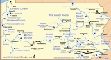
Bald Eagle and Spring Creek Navigation
Encyclopedia
The Bald Eagle and Spring Creek Navigation Company was a canal
company in central Pennsylvania
intended to link the iron industry of Bellefonte, Pennsylvania
, with the Pennsylvania canal system. Opened for half its length in 1837, the remainder of the canal was not completed until 1848. Destroyed by flooding in 1865, it was not rebuilt; a paralleling railroad completed that year replaced it.
, a suburb of Lock Haven
, to Bellefonte on April 14, 1834. Lock Haven was the terminus of the West Branch Canal
, part of Pennsylvania's state-owned canal system following the West Branch Susquehanna River
. The canal was planned to follow Bald Eagle Creek
southwest through its valley
as far as Milesburg
, and then turn south to follow Spring Creek through its water gap
in Bald Eagle Mountain
to Bellefonte, center of the local iron industry. In theory, this entire route was navigable—residents of Bellefonte were said to have dragged a flatboat
up Spring Creek in order to prove the town the head of navigation and beat out Milesburg as the county seat
of Centre County
in 1800—but in practice, improvements were necessary to facilitate the heavy traffic in iron from the furnaces.
In preparation for the building of the Bald Eagle & Spring Creek, the Bald Eagle Cut, a 4 miles (6.4 km) waterway, was built from the West Branch Canal through Lock Haven to the Bald Eagle Creek and the foot of the new canal. The 12.5 miles (20.1 km) Lower Division of the Bald Eagle & Spring Creek was opened from Flemington to Howard
, site of an iron furnace, in the fall of 1837. However, the Panic of 1837
led to straitened economic conditions throughout the country, and delayed further construction for a decade. The next segment, from Howard to Milesburg, was opened on September 3, 1837. The final segment along Spring Creek into Bellefonte, completing the 12.5 miles (20.1 km) Upper Division, was opened on September 1, 1848. The first canal boat
to arrive from Philadelphia was the Jane Curtin, carrying supplies for the Valentine & Thomas ironworks.
and pig iron
to downstream consumers, as well as a carrier of local agricultural traffic. However, the Commonwealth of Pennsylvania was experiencing increasing difficulties in funding the maintenance of its over-extended canal network. The Commonwealth was already involved in the financing of the Bald Eagle & Spring Creek, as guarantor of the annual interest on its stock, and it, together with the Bald Eagle Cross-Cut, the West Branch Canal, and the Susquehanna Division of the Pennsylvania Canal
was divested in 1857. These waterways were initially given to the Sunbury and Erie Railroad, to help fund its completion, which in turn sold them to be organized as the West Branch and Susquehanna Canal.
During 1857, the canal was threatened by the prospect of a competitor. The Tyrone and Lock Haven Railroad was chartered to run down the Bald Eagle Valley between Tyrone
and Lock Haven, and to build a branch to Bellefonte, paralleling the canal route. However, the Tyrone & Lock Haven was unable to secure sufficient financing for its immediate construction, completing only the branch from Bellefonte to Milesburg and a short section of line from Milesburg to the Bellefonte and Snow Shoe Railroad at Wingate by 1859. It was operated by the latter road for the next several years. Initially, the railroad was something of a boon to the canal: docks were built on the canal at Milesburg so that coal carried down by the railroad from the Snow Shoe area could be loaded into eastbound canal boats. However, this state of affairs was not to last. The Pennsylvania Railroad
took up the financing of the Tyrone & Lock Haven, reorganized it as the Bald Eagle Valley Railroad
, and pushed it to completion along the length of the Bald Eagle Valley in 1865.
The doom of the Bald Eagle and Spring Creek Navigation was at hand. Major flooding took place in the Susquehanna watershed during March 15–17, 1865, ravaging the canal infrastructure. With little prospect of effective competition with the new railroad line, it was never rebuilt.
Stonework from one of the locks is still visible at the former site of the McCoy and Linn ironworks, in the water gap of Spring Creek between Bellefonte and Milesburg. (The canal lock itself was not impacted by the removal of the 1926 hydroelectric dam at the ironworks site in August and September 2007, but the canal basin between the lock and the dam was filled in with the dam rubble as well as sediments that had built up behind the dam.) It is hoped that future archaeological work may be carried out on the lock itself and the stonework is in places in need of stabilization.
The remains of Locks #4 and #5 of this canal were included in the National Register of Historic Places
nomination for Harmony Forge Mansion
, and listed in 1979.
Canal
Canals are man-made channels for water. There are two types of canal:#Waterways: navigable transportation canals used for carrying ships and boats shipping goods and conveying people, further subdivided into two kinds:...
company in central Pennsylvania
Pennsylvania
The Commonwealth of Pennsylvania is a U.S. state that is located in the Northeastern and Mid-Atlantic regions of the United States. The state borders Delaware and Maryland to the south, West Virginia to the southwest, Ohio to the west, New York and Ontario, Canada, to the north, and New Jersey to...
intended to link the iron industry of Bellefonte, Pennsylvania
Bellefonte, Pennsylvania
Bellefonte is a borough in Centre County, Pennsylvania, United States. It lies about twelve miles northeast of State College and is part of the State College, Pennsylvania Metropolitan Statistical Area...
, with the Pennsylvania canal system. Opened for half its length in 1837, the remainder of the canal was not completed until 1848. Destroyed by flooding in 1865, it was not rebuilt; a paralleling railroad completed that year replaced it.
Charter and construction
The company was incorporated to build a canal from Flemington, PennsylvaniaFlemington, Pennsylvania
Flemington is a borough in Clinton County, Pennsylvania, USA. The population was 1,319 at the 2000 census.-Geography:Flemington is located at , along the Bald Eagle Creek and the remnant of the Bald Eagle Crosscut Canal.According to the United States Census Bureau, the borough has a total area of...
, a suburb of Lock Haven
Lock Haven, Pennsylvania
The city of Lock Haven is the county seat of Clinton County, in the U.S. state of Pennsylvania. Located near the confluence of the West Branch Susquehanna River and Bald Eagle Creek, it is the principal city of the Lock Haven, Pennsylvania, micropolitan statistical area, itself part of the...
, to Bellefonte on April 14, 1834. Lock Haven was the terminus of the West Branch Canal
Pennsylvania Canal (West Branch Division)
The West Branch Division of the Pennsylvania Canal ran from the canal basin at Northumberland, Pennsylvania, at the confluence of the West Branch Susquehanna River with the main stem of the Susquehanna River, north through Muncy, then west through Williamsport, Jersey Shore, and Lock Haven to its...
, part of Pennsylvania's state-owned canal system following the West Branch Susquehanna River
West Branch Susquehanna River
The West Branch Susquehanna River is one of the two principal branches, along with the North Branch, of the Susquehanna River in the northeastern United States. The North Branch, which rises in upstate New York, is generally regarded as the extension of the main branch, with the shorter West Branch...
. The canal was planned to follow Bald Eagle Creek
Bald Eagle Creek
Bald Eagle Creek is a tributary of the Little Juniata River in Blair County, Pennsylvania, in the United States. It runs southwest through the Bald Eagle Valley at the foot of the Bald Eagle Mountain ridge to Tyrone....
southwest through its valley
Bald Eagle Valley
The Bald Eagle Valley of central Pennsylvania, United States is the low lying area draining into the Bald Eagle Creek between the Allegheny Front and the Bald Eagle Mountain ridge, south of the West Branch Susquehanna River, in the Ridge-and-valley Appalachians...
as far as Milesburg
Milesburg, Pennsylvania
Milesburg is a borough in Centre County, Pennsylvania, United States. It is part of the State College, Pennsylvania Metropolitan Statistical Area. The population was 1,187 at the 2000 census...
, and then turn south to follow Spring Creek through its water gap
Water gap
A water gap is an opening or notch which flowing water has carved through a mountain range. Water gaps often offer a practical route for road and rail transport to cross mountain ridges.- Geology :...
in Bald Eagle Mountain
Bald Eagle Mountain
Bald Eagle Mountain, once known locally as Muncy Mountain, is a stratigraphic ridge in central Pennsylvania, United States, running east of the Allegheny Front and northwest of Mount Nittany. It lies along the southeast side of Bald Eagle Creek, and south of the West Branch Susquehanna River, and...
to Bellefonte, center of the local iron industry. In theory, this entire route was navigable—residents of Bellefonte were said to have dragged a flatboat
Flatboat
Fil1800flatboat.jpgA flatboat is a rectangular flat-bottomed boat with Fil1800flatboat.jpgA flatboat is a rectangular flat-bottomed boat with Fil1800flatboat.jpgA flatboat is a rectangular flat-bottomed boat with (mostlyNOTE: "(parenthesized)" wordings in the quote below are notes added to...
up Spring Creek in order to prove the town the head of navigation and beat out Milesburg as the county seat
County seat
A county seat is an administrative center, or seat of government, for a county or civil parish. The term is primarily used in the United States....
of Centre County
Centre County, Pennsylvania
Centre County is a county located in the U.S. state of Pennsylvania. It is part of the State College, Pennsylvania Metropolitan Statistical Area. As of 2010, the population was 153,990....
in 1800—but in practice, improvements were necessary to facilitate the heavy traffic in iron from the furnaces.
In preparation for the building of the Bald Eagle & Spring Creek, the Bald Eagle Cut, a 4 miles (6.4 km) waterway, was built from the West Branch Canal through Lock Haven to the Bald Eagle Creek and the foot of the new canal. The 12.5 miles (20.1 km) Lower Division of the Bald Eagle & Spring Creek was opened from Flemington to Howard
Howard, Pennsylvania
Howard is a borough in Centre County, Pennsylvania, United States. It is part of the State College, Pennsylvania Metropolitan Statistical Area. The population was 720 at the 2010 census.-Geography:Howard is located at ....
, site of an iron furnace, in the fall of 1837. However, the Panic of 1837
Panic of 1837
The Panic of 1837 was a financial crisis or market correction in the United States built on a speculative fever. The end of the Second Bank of the United States had produced a period of runaway inflation, but on May 10, 1837 in New York City, every bank began to accept payment only in specie ,...
led to straitened economic conditions throughout the country, and delayed further construction for a decade. The next segment, from Howard to Milesburg, was opened on September 3, 1837. The final segment along Spring Creek into Bellefonte, completing the 12.5 miles (20.1 km) Upper Division, was opened on September 1, 1848. The first canal boat
Canal boat
There are three articles associated with canal watercraft:* The Volunteer - A replica 1848 canal boat docked on the Illinois and Michigan Canal at LaSalle, Illinois* Narrowboat - a specialized craft for operation in early narrow canals...
to arrive from Philadelphia was the Jane Curtin, carrying supplies for the Valentine & Thomas ironworks.
Operation and destruction
The canal quickly became a major shipper of bituminous coalBituminous coal
Bituminous coal or black coal is a relatively soft coal containing a tarlike substance called bitumen. It is of higher quality than lignite coal but of poorer quality than Anthracite...
and pig iron
Pig iron
Pig iron is the intermediate product of smelting iron ore with a high-carbon fuel such as coke, usually with limestone as a flux. Charcoal and anthracite have also been used as fuel...
to downstream consumers, as well as a carrier of local agricultural traffic. However, the Commonwealth of Pennsylvania was experiencing increasing difficulties in funding the maintenance of its over-extended canal network. The Commonwealth was already involved in the financing of the Bald Eagle & Spring Creek, as guarantor of the annual interest on its stock, and it, together with the Bald Eagle Cross-Cut, the West Branch Canal, and the Susquehanna Division of the Pennsylvania Canal
Pennsylvania Canal
Pennsylvania Canal refers generally to a complex system of canals, dams, locks, tow paths, aqueducts, and other infrastructure including, in some cases, railroads in Pennsylvania...
was divested in 1857. These waterways were initially given to the Sunbury and Erie Railroad, to help fund its completion, which in turn sold them to be organized as the West Branch and Susquehanna Canal.
During 1857, the canal was threatened by the prospect of a competitor. The Tyrone and Lock Haven Railroad was chartered to run down the Bald Eagle Valley between Tyrone
Tyrone, Pennsylvania
Tyrone is a borough in Blair County, Pennsylvania, northeast of Altoona, on the Little Juniata River. Tyrone was of considerable commercial importance in the twentieth century. It was an outlet for the Clearfield coal fields, and it was noted for the manufacture of paper products. There were...
and Lock Haven, and to build a branch to Bellefonte, paralleling the canal route. However, the Tyrone & Lock Haven was unable to secure sufficient financing for its immediate construction, completing only the branch from Bellefonte to Milesburg and a short section of line from Milesburg to the Bellefonte and Snow Shoe Railroad at Wingate by 1859. It was operated by the latter road for the next several years. Initially, the railroad was something of a boon to the canal: docks were built on the canal at Milesburg so that coal carried down by the railroad from the Snow Shoe area could be loaded into eastbound canal boats. However, this state of affairs was not to last. The Pennsylvania Railroad
Pennsylvania Railroad
The Pennsylvania Railroad was an American Class I railroad, founded in 1846. Commonly referred to as the "Pennsy", the PRR was headquartered in Philadelphia, Pennsylvania....
took up the financing of the Tyrone & Lock Haven, reorganized it as the Bald Eagle Valley Railroad
Bald Eagle Valley Railroad
The Bald Eagle Valley Railroad was a subsidiary of the Pennsylvania Railroad which owned several rail lines in central Pennsylvania. It had its genesis in the Tyrone and Lock Haven Railroad, a financially-troubled railroad chartered in 1857, which was unable to complete more than a small portion of...
, and pushed it to completion along the length of the Bald Eagle Valley in 1865.
The doom of the Bald Eagle and Spring Creek Navigation was at hand. Major flooding took place in the Susquehanna watershed during March 15–17, 1865, ravaging the canal infrastructure. With little prospect of effective competition with the new railroad line, it was never rebuilt.
Stonework from one of the locks is still visible at the former site of the McCoy and Linn ironworks, in the water gap of Spring Creek between Bellefonte and Milesburg. (The canal lock itself was not impacted by the removal of the 1926 hydroelectric dam at the ironworks site in August and September 2007, but the canal basin between the lock and the dam was filled in with the dam rubble as well as sediments that had built up behind the dam.) It is hoped that future archaeological work may be carried out on the lock itself and the stonework is in places in need of stabilization.
The remains of Locks #4 and #5 of this canal were included in the National Register of Historic Places
National Register of Historic Places
The National Register of Historic Places is the United States government's official list of districts, sites, buildings, structures, and objects deemed worthy of preservation...
nomination for Harmony Forge Mansion
Harmony Forge Mansion
Harmony Forge Mansion is a historic home and property located at Boggs Township, Centre County, Pennsylvania. It was built between 1810 and 1820 by Joseph Miles, and is a 2 1/2 story, 5-bay stone building, with a 2-story stone kitchen wing. It measures 44 feet, 6 inches, by 40 feet...
, and listed in 1979.
Points of interest
| Feature | Coordinates | Description |
|---|---|---|
| Flemington Flemington, Pennsylvania Flemington is a borough in Clinton County, Pennsylvania, USA. The population was 1,319 at the 2000 census.-Geography:Flemington is located at , along the Bald Eagle Creek and the remnant of the Bald Eagle Crosscut Canal.According to the United States Census Bureau, the borough has a total area of... |
41°07′21"N 77°28′13"W | Borough Borough A borough is an administrative division in various countries. In principle, the term borough designates a self-governing township although, in practice, official use of the term varies widely.... at the eastern terminus |
| Howard Howard, Pennsylvania Howard is a borough in Centre County, Pennsylvania, United States. It is part of the State College, Pennsylvania Metropolitan Statistical Area. The population was 720 at the 2010 census.-Geography:Howard is located at .... |
41°00′51"N 77°39′29"W | Borough near the mid-point of the canal |
| Bellefonte Bellefonte, Pennsylvania Bellefonte is a borough in Centre County, Pennsylvania, United States. It lies about twelve miles northeast of State College and is part of the State College, Pennsylvania Metropolitan Statistical Area... |
40°54′48"N 77°46′42"W | Borough at the western terminus |