
Arkansas-Mississippi-Alabama tornado outbreak
Encyclopedia
The Arkansas–Mississippi–Alabama tornado outbreak is a fall tornado outbreak
which affected portions of the southern United States
from Arkansas
to Alabama
on November 23-November 24, 2001 with additional tornadoes recorded in Louisiana
, Kentucky
, Missouri
, Indiana
and Georgia. Recorded as one of the most intense November outbreaks ever across that area, tornadoes from that event have killed at least 13 across three states including 4 in Alabama, four in Arkansas and five in Mississippi
.
. Its associated cold front traversed much of the outbreak affected area with several supercells forming ahead of front. Rich moist air from the Gulf of Mexico and cold air aloft and wind shear provided the ingredients from a significant severe weather outbreak.
 Supercells formed late across much of Arkansas and Mississippi during the evening hours of November 23 up into the early morning hours of November 24 produced several tornadoes including two F4 Mississippi tornadoes across Washington
and Bolivar
Counties at around 2 AM and in Madison County
near the city of Madison
at around 5 AM. The second tornado killed at least 2 (including a newborn baby) and injured 21. Another tornado in Mississippi, an F2, struck Quitman
, Panola
and Tate
Counties just after 3 AM and killed at least three. In Arkansas, four people were killed by two separate tornadoes including three in Ashley County from a single tornado that moved from Louisiana.
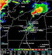
Activity shifted into Alabama during midday on November 24 where numerous supercells traveled across the Birmingham
coverage area. There were at least, according to the National Weather Service
in Birmingham, 13 supercells that produced tornadoes including an F4 tornadoes that traversed Blount
and Etowah
Counties just after 1:00 PM. Activity ceased just after midnight with the final tornadoes touching down across Alabama in Dale County
. In Alabama alone, 4 people were killed by two separate tornadoes including 2 from an F3 that moved from Pickens County
northeastward and north of Birmingham and Tuscaloosa
towards Walker County
. Another tornado killed 2 in Cherokee County
in the northeastern part of the state.
Tornado outbreak
While there is no single agreed upon definition, generally at least 6-10 tornadoes produced by the same synoptic scale weather system is considered a tornado outbreak. The tornadoes usually occur within the same day, or continue into the early morning hours of the succeeding day, and within the...
which affected portions of the southern United States
United States
The United States of America is a federal constitutional republic comprising fifty states and a federal district...
from Arkansas
Arkansas
Arkansas is a state located in the southern region of the United States. Its name is an Algonquian name of the Quapaw Indians. Arkansas shares borders with six states , and its eastern border is largely defined by the Mississippi River...
to Alabama
Alabama
Alabama is a state located in the southeastern region of the United States. It is bordered by Tennessee to the north, Georgia to the east, Florida and the Gulf of Mexico to the south, and Mississippi to the west. Alabama ranks 30th in total land area and ranks second in the size of its inland...
on November 23-November 24, 2001 with additional tornadoes recorded in Louisiana
Louisiana
Louisiana is a state located in the southern region of the United States of America. Its capital is Baton Rouge and largest city is New Orleans. Louisiana is the only state in the U.S. with political subdivisions termed parishes, which are local governments equivalent to counties...
, Kentucky
Kentucky
The Commonwealth of Kentucky is a state located in the East Central United States of America. As classified by the United States Census Bureau, Kentucky is a Southern state, more specifically in the East South Central region. Kentucky is one of four U.S. states constituted as a commonwealth...
, Missouri
Missouri
Missouri is a US state located in the Midwestern United States, bordered by Iowa, Illinois, Kentucky, Tennessee, Arkansas, Oklahoma, Kansas and Nebraska. With a 2010 population of 5,988,927, Missouri is the 18th most populous state in the nation and the fifth most populous in the Midwest. It...
, Indiana
Indiana
Indiana is a US state, admitted to the United States as the 19th on December 11, 1816. It is located in the Midwestern United States and Great Lakes Region. With 6,483,802 residents, the state is ranked 15th in population and 16th in population density. Indiana is ranked 38th in land area and is...
and Georgia. Recorded as one of the most intense November outbreaks ever across that area, tornadoes from that event have killed at least 13 across three states including 4 in Alabama, four in Arkansas and five in Mississippi
Mississippi
Mississippi is a U.S. state located in the Southern United States. Jackson is the state capital and largest city. The name of the state derives from the Mississippi River, which flows along its western boundary, whose name comes from the Ojibwe word misi-ziibi...
.
The event
A low pressure system was situated, just after 5 AM on November 24, near Kansas City, MissouriKansas City, Missouri
Kansas City, Missouri is the largest city in the U.S. state of Missouri and is the anchor city of the Kansas City Metropolitan Area, the second largest metropolitan area in Missouri. It encompasses in parts of Jackson, Clay, Cass, and Platte counties...
. Its associated cold front traversed much of the outbreak affected area with several supercells forming ahead of front. Rich moist air from the Gulf of Mexico and cold air aloft and wind shear provided the ingredients from a significant severe weather outbreak.
Washington County, Mississippi
-National protected areas:*Holt Collier National Wildlife Refuge*Theodore Roosevelt National Wildlife Refuge *Yazoo National Wildlife Refuge-Demographics:...
and Bolivar
Bolivar County, Mississippi
-Demographics:As of the census of 2000, there were 40,633 people, 13,776 households, and 9,725 families residing in the county. The population density was 46 people per square mile . There were 14,939 housing units at an average density of 17 per square mile...
Counties at around 2 AM and in Madison County
Madison County, Mississippi
-Demographics:As of the census of 2000, there were 74,674 people, 27,219 households, and 19,325 families residing in the county. The population density was 104 people per square mile . There were 28,781 housing units at an average density of 40 per square mile...
near the city of Madison
Madison, Mississippi
Madison is a city in Madison County, Mississippi, USA. The population was 14,691 at the 2000 census. The population is currently 16,930. It is part of the Jackson Metropolitan Statistical Area. It is currently the highest income city in the state...
at around 5 AM. The second tornado killed at least 2 (including a newborn baby) and injured 21. Another tornado in Mississippi, an F2, struck Quitman
Quitman County, Mississippi
-Demographics:As of the census of 2000, there were 10,117 people, 3,565 households, and 2,506 families residing in the county. The population density was 25 people per square mile . There were 3,923 housing units at an average density of 10 per square mile...
, Panola
Panola County, Mississippi
-Demographics:As of the census of 2000, there were 34,274 people, 12,232 households, and 9,014 families residing in the county. The population density was 50 people per square mile . There were 13,736 housing units at an average density of 20 per square mile...
and Tate
Tate County, Mississippi
-Demographics:As of the census of 2000, there were 25,370 people, 8,850 households, and 6,717 families residing in the county. The population density was 63 people per square mile . There were 9,354 housing units at an average density of 23 per square mile...
Counties just after 3 AM and killed at least three. In Arkansas, four people were killed by two separate tornadoes including three in Ashley County from a single tornado that moved from Louisiana.
| State | Total | County | County total |
|---|---|---|---|
| Alabama Alabama Alabama is a state located in the southeastern region of the United States. It is bordered by Tennessee to the north, Georgia to the east, Florida and the Gulf of Mexico to the south, and Mississippi to the west. Alabama ranks 30th in total land area and ranks second in the size of its inland... |
4 | Cherokee Cherokee County, Alabama Cherokee County, Alabama is a county of the U.S. state of Alabama. It is named for the Cherokee tribe. As of 2010 the population was 25,989. Its county seat is Centre and it is a prohibition or dry county.- History :... |
2 |
| Lamar Lamar County, Alabama Lamar County is a county of the U.S. state of Alabama. Its name is in honor of Lucius Quintus Cincinnatus Lamar, member of the United States Senate from Mississippi. As of 2010 the population was 14,564... |
2 | ||
| Arkansas Arkansas Arkansas is a state located in the southern region of the United States. Its name is an Algonquian name of the Quapaw Indians. Arkansas shares borders with six states , and its eastern border is largely defined by the Mississippi River... |
4 | Ashley | 3 |
| Johnson | 1 | ||
| Mississippi Mississippi Mississippi is a U.S. state located in the Southern United States. Jackson is the state capital and largest city. The name of the state derives from the Mississippi River, which flows along its western boundary, whose name comes from the Ojibwe word misi-ziibi... |
5 | Madison Madison County, Mississippi -Demographics:As of the census of 2000, there were 74,674 people, 27,219 households, and 19,325 families residing in the county. The population density was 104 people per square mile . There were 28,781 housing units at an average density of 40 per square mile... |
2 |
| Panola Panola County, Mississippi -Demographics:As of the census of 2000, there were 34,274 people, 12,232 households, and 9,014 families residing in the county. The population density was 50 people per square mile . There were 13,736 housing units at an average density of 20 per square mile... |
1 | ||
| Quitman Quitman County, Mississippi -Demographics:As of the census of 2000, there were 10,117 people, 3,565 households, and 2,506 families residing in the county. The population density was 25 people per square mile . There were 3,923 housing units at an average density of 10 per square mile... |
2 | ||
| Totals | 13 | ||
| All deaths were tornado-related | |||
Activity shifted into Alabama during midday on November 24 where numerous supercells traveled across the Birmingham
Birmingham, Alabama
Birmingham is the largest city in Alabama. The city is the county seat of Jefferson County. According to the 2010 United States Census, Birmingham had a population of 212,237. The Birmingham-Hoover Metropolitan Area, in estimate by the U.S...
coverage area. There were at least, according to the National Weather Service
National Weather Service
The National Weather Service , once known as the Weather Bureau, is one of the six scientific agencies that make up the National Oceanic and Atmospheric Administration of the United States government...
in Birmingham, 13 supercells that produced tornadoes including an F4 tornadoes that traversed Blount
Blount County, Alabama
Blount County is a county located in the U.S. state of Alabama. As of the 2010 United States Census, the population was 57,322. Its county seat is Oneonta.Blount County is a dry county.-History:...
and Etowah
Etowah County, Alabama
Etowah County is a county of the U.S. state of Alabama. Its name is from the Cherokee language, which means "edible tree". It is the center of the Gadsden Metropolitan Area which includes Etowah and Cherokee Counties. As of 2010 the population was 104,430. Its county seat is Gadsden...
Counties just after 1:00 PM. Activity ceased just after midnight with the final tornadoes touching down across Alabama in Dale County
Dale County, Alabama
Dale County is a county of the U.S. state of Alabama. Its name is in honor of General Samuel Dale. As of the 2010 census the population was 50,251...
. In Alabama alone, 4 people were killed by two separate tornadoes including 2 from an F3 that moved from Pickens County
Pickens County, Alabama
Pickens County is a county of the U.S. state of Alabama. As of 2010, the population was 19,746. Its county seat is Carrollton, and it is a prohibition, or dry county.-History:...
northeastward and north of Birmingham and Tuscaloosa
Tuscaloosa, Alabama
Tuscaloosa is a city in and the seat of Tuscaloosa County in west central Alabama . Located on the Black Warrior River, it is the fifth-largest city in Alabama, with a population of 90,468 in 2010...
towards Walker County
Walker County, Alabama
Walker County is a county of the U.S. state of Alabama.Its name is in honor of John Williams Walker, a member of the United States Senate. As of 2010 the population was 67,023...
. Another tornado killed 2 in Cherokee County
Cherokee County, Alabama
Cherokee County, Alabama is a county of the U.S. state of Alabama. It is named for the Cherokee tribe. As of 2010 the population was 25,989. Its county seat is Centre and it is a prohibition or dry county.- History :...
in the northeastern part of the state.
November 23 event
| F# Fujita scale The Fujita scale , or Fujita-Pearson scale, is a scale for rating tornado intensity, based primarily on the damage tornadoes inflict on human-built structures and vegetation... |
Location | County | Time (UTC) | Path length | Damage | |
|---|---|---|---|---|---|---|
| Arkansas Arkansas Arkansas is a state located in the southern region of the United States. Its name is an Algonquian name of the Quapaw Indians. Arkansas shares borders with six states , and its eastern border is largely defined by the Mississippi River... |
||||||
| F1 | SW of Greenwood Greenwood, Arkansas Greenwood is a city in and one of the two county seats of Sebastian County, Arkansas, United States, perhaps best known locally for its Arkansas high school football... |
Franklin, Logan Logan County, Arkansas Logan County is a county located in the U.S. state of Arkansas. As of 2010, the population was 22,353. There are two county seats: Booneville and Paris.-History :... |
0125 | 8 miles (12.8 km) |
Several barns and one house were damaged | |
| F2 | NW of Altus Altus, Arkansas Altus is a town in Franklin County, Arkansas, United States. It is part of the Fort Smith, Arkansas-Oklahoma Metropolitan Statistical Area. The population was 817 at the 2000 census. When the Iron Mountain Railroad laid rails up the Arkansas River Valley in the 1870s from Little Rock to the... to N of Salus |
Franklin, Johnson, Newton Newton County, Arkansas Newton County is a county located in the U.S. state of Arkansas. As of 2010, the population is 8,330. The county seat is Jasper. Newton County is Arkansas's 46th county, formed on December 14, 1842, and named for Thomas W. Newton, an Arkansas Congressman... |
0136 | 31.5 miles (50.4 km) |
1 death Fatality was inside a mobile home and 4 others were injured. Several homes were damaged some of them heavily. Several mobile homes, barns, outbuildings, six chicken houses and two turkey houses were destroyed. Numerous chickens that were inside chicken houses were killed. Numerous trees at a national forest were downed. | |
| F1 | NE of Altus Altus, Arkansas Altus is a town in Franklin County, Arkansas, United States. It is part of the Fort Smith, Arkansas-Oklahoma Metropolitan Statistical Area. The population was 817 at the 2000 census. When the Iron Mountain Railroad laid rails up the Arkansas River Valley in the 1870s from Little Rock to the... |
Franklin, Johnson | 0140 | 8.8 miles (14.1 km) |
Damage to barns, homes and power lines. | |
| F2 | NW of Limestone | Newton Newton County, Arkansas Newton County is a county located in the U.S. state of Arkansas. As of 2010, the population is 8,330. The county seat is Jasper. Newton County is Arkansas's 46th county, formed on December 14, 1842, and named for Thomas W. Newton, an Arkansas Congressman... |
0224 | 18.5 miles (29.6 km) |
Major damage to an Inn and a restaurant. Several homes were damaged and outbuildings were destroyed. | |
| F1 | SW of Pyatt Pyatt, Arkansas Pyatt is a town in Marion County, Arkansas, United States. The population was 253 at the 2000 census.-Geography:Pyatt is located at .According to the United States Census Bureau, the town has a total area of , all land.... |
Boone Boone County, Arkansas Boone County is a county located in the U.S. state of Arkansas. As of the 2010 census, the population was 36,903. The county seat is Harrison. Boone County is Arkansas's 62nd county, formed on April 9, 1869. Boone County is part of the Harrison Micropolitan Statistical Area.-History:Boone County... , Marion |
0303 | 8 miles (12.8 km) |
Three barns, a house and garage were heavily or destroyed with several other homes receiving minor damage | |
| F2 | SW of Searcy Searcy, Arkansas Searcy is the largest city and county seat of White County, Arkansas, United States. According to 2006 Census Bureau estimates, the population of the city is 20,663. It is the principal city of the Searcy, AR Micropolitan Statistical Area which encompasses all of White County... |
White White County, Arkansas White County is a county located in the U.S. state of Arkansas. As of 2010, the population was 77,076. The county seat is Searcy. White County is Arkansas's 31st county, formed on October 23, 1835, from portions of Independence, Jackson, and Pulaski counties and named for Hugh Lawson White, a... |
0725 | 5.5 miles (8.8 km) |
A small house and trailer was destroyed and one house was shifted from its foundation. Dozen of other structures were damaged and there were 3 injuries. | |
| F1 | SW of Fairview | Chicot Chicot County, Arkansas Chicot County is a county located in the U.S. state of Arkansas. As of 2010, the population is 11,800. The county seat is Lake Village. Chicot County is Arkansas's tenth county, formed on October 25, 1823, and named after Point Chicot on the Mississippi River.Landmarks around the county include... |
0731 | 1 miles (1.6 km) |
Four house and a mobile home were damaged | |
| Missouri Missouri Missouri is a US state located in the Midwestern United States, bordered by Iowa, Illinois, Kentucky, Tennessee, Arkansas, Oklahoma, Kansas and Nebraska. With a 2010 population of 5,988,927, Missouri is the 18th most populous state in the nation and the fifth most populous in the Midwest. It... |
||||||
| F2 | N of Exeter Exeter, Missouri Exeter is a city in Exeter Township, Barry County, Missouri, USA. The population was 707 at the 2000 census.-Geography:Exeter is located at .... |
Barry Barry County, Missouri Barry County is a county located in the U.S. state of Missouri. As of 2010, the population was 35,597. Its county seat is Cassville. The county was organized in 1835 and named after William Taylor Barry from Kentucky, a United States Postmaster General.... |
0228 | 4 miles (6.4 km) |
Significant damage to several residences. Two storage buildings were swept from their foundation. Damage also to chicken houses and grain bins and outbuildings were destroyed. 3 people were injured. | |
| F1 | NE of Opal | Lawrence | 0320 | 2 miles (3.2 km) |
Roof damage to a firehouse and several homes. A steeple from a church was also toppled. Poultry houses were destroyed. | |
| Louisiana Louisiana Louisiana is a state located in the southern region of the United States of America. Its capital is Baton Rouge and largest city is New Orleans. Louisiana is the only state in the U.S. with political subdivisions termed parishes, which are local governments equivalent to counties... |
||||||
| F1 | W of Eros Eros, Louisiana Eros is a town in Jackson Parish, Louisiana, United States. The population was 202 at the 2000 census. It is part of the Ruston Micropolitan Statistical Area.Former Northwestern State University President Arnold R. Kilpatrick was born in Eros... |
Jackson Jackson Parish, Louisiana Jackson Parish is a parish located in the U.S. state of Louisiana. The parish was formed in 1845 from parts of Claiborne, Ouachita, and Union Parishes. In 2010, its population was 16,274. The parish seat is Jonesboro... , Ouachita Ouachita Parish, Louisiana -National protected areas:* Black Bayou Lake National Wildlife Refuge* D'Arbonne National Wildlife Refuge -Demographics:As of the census of 2000, there were 147,250 people, 55,216 households, and 38,319 families residing in the parish. The population density was 241 people per square mile... |
0539 | 9 miles (14.4 km) |
Damage to a carport, chicken house and mobile home. | |
| F3 | NE of Bastrop, LA Bastrop, Louisiana Bastrop is a city in and the parish seat of Morehouse Parish, Louisiana, United States. The population was 12,988 at the 2000 census. It is the principal city of and is included in the Bastrop, Louisiana Micropolitan Statistical Area, which is included in the Monroe-Bastrop, Louisiana Combined... to NE of Parkdale, AR Parkdale, Arkansas Parkdale is a city in Ashley County, Arkansas, United States. The population was 377 at the 2000 census.-Geography:Parkdale is located at .According to the United States Census Bureau, the city has a total area of , all land.... |
Morehouse, LA Morehouse Parish, Louisiana Morehouse Parish is a parish located in the U.S. state of Louisiana. The parish seat is Bastrop. In 2000, the parish population was 31,021.... , Ashley, AR |
0640 | 30 miles (48 km) |
3 deaths In Arkansas, a tractor shed, a church, 14 mobile homes and homes were destroyed and five other homes were severely damaged in Wilmot Wilmot, Arkansas Wilmot is a city in Ashley County, Arkansas, United States. The population was 786 at the 2000 census.-Geography:Wilmot is located at .... where three people were killed. In Louisiana, there was extensive damage to a potato plant, farm buildings and one house. |
|
| F1 | S of Faircloth | Grant Grant Parish, Louisiana -Demographics:As of the census of 2000, there were 18,698 people, 7,073 households, and 5,276 families residing in the parish. The population density was 29 people per square mile . There were 8,531 housing units at an average density of 13 per square mile... |
0643 | 11.5 miles (18.4 km) |
Damage limited to trees | |
| F0 | SE of Curry | Winn Winn Parish, Louisiana Winn Parish is a parish located in the U.S. state of Louisiana. Its seat is Winnfield. In 2000, its population was 16,894.The parish has a total area of , of which, of it is land and of it is water.... |
0714 | 2.9 miles (4.6 km) |
Damage to trees and street signs | |
| F1 | W of Grayson Grayson, Louisiana Grayson is a village in Caldwell Parish, Louisiana, United States. The population was 531 at the 2000 census.Grayson has an elementary school, but high school students attend the nearby Caldwell Parish High School in the parish seat of Columbia. Across from the elementary school and the Grayson... |
Caldwell Caldwell Parish, Louisiana -Demographics:As of the census of 2000, there were 10,560 people, 3,941 households, and 2,817 families residing in the parish. The population density was 20 people per square mile . There were 5,035 housing units at an average density of 10 per square mile... |
0735 | 5 miles (8 km) |
Damage limited to trees | |
| Mississippi Mississippi Mississippi is a U.S. state located in the Southern United States. Jackson is the state capital and largest city. The name of the state derives from the Mississippi River, which flows along its western boundary, whose name comes from the Ojibwe word misi-ziibi... |
||||||
| F4 | SW of Winterville Winterville, Mississippi Winterville is an unincorporated community located in Washington County, Mississippi, United States near Mississippi Highway 1. Winterville is approximately north of Greenville and approximately south of Lamont.... to S of Mound Bayou Mound Bayou, Mississippi Mound Bayou is a city in Bolivar County, Mississippi. The population was 2,102 at the 2000 census. It is notable for having been founded as an independent black community in 1887 by former slaves led by Isaiah Montgomery. By percentage, its 98.4 percent African-American majority population is one... |
Washington Washington County, Mississippi -National protected areas:*Holt Collier National Wildlife Refuge*Theodore Roosevelt National Wildlife Refuge *Yazoo National Wildlife Refuge-Demographics:... , Bolivar Bolivar County, Mississippi -Demographics:As of the census of 2000, there were 40,633 people, 13,776 households, and 9,725 families residing in the county. The population density was 46 people per square mile . There were 14,939 housing units at an average density of 17 per square mile... |
0755 | 30.3 miles (48.5 km) |
A total of 48 people were injured by the storm. 16 homes, seven mobile homes, six businesses and a power substation were destroyed. Numerous other structures including homes and mobile homes sustained minor to severe damage. | |
| Source: Tornado History Project Storm Data - November 23, 2001 | ||||||
November 24 event
| F# Fujita scale The Fujita scale , or Fujita-Pearson scale, is a scale for rating tornado intensity, based primarily on the damage tornadoes inflict on human-built structures and vegetation... |
Location | County | Time (UTC) | Path length | Damage | |
|---|---|---|---|---|---|---|
| Louisiana Louisiana Louisiana is a state located in the southern region of the United States of America. Its capital is Baton Rouge and largest city is New Orleans. Louisiana is the only state in the U.S. with political subdivisions termed parishes, which are local governments equivalent to counties... |
||||||
| F2 | S of Big Bend | Avoyelles Avoyelles Parish, Louisiana Avoyelles is a parish located in the U.S. state of Louisiana. The parish seat is Marksville. In 2000, its population was 41,481. The parish is named for the Avoyel Indian tribe.-History:... |
0805 | 1 miles (1.6 km) |
One mobile home was destroyed, its three occupants being injured | |
| F0 | NW of Afton | Madison Madison Parish, Louisiana -National protected areas:* Tensas River National Wildlife Refuge * Vicksburg National Military Park -Demographics:-2010:Whereas according to the 2010 U.S... |
1210 | 0.5 miles (0.8 km) |
A shed was blown away | |
| Mississippi Mississippi Mississippi is a U.S. state located in the Southern United States. Jackson is the state capital and largest city. The name of the state derives from the Mississippi River, which flows along its western boundary, whose name comes from the Ojibwe word misi-ziibi... |
||||||
| F1 | SW of Baltzer Baltzer, Mississippi Baltzer is an unincorporated community located in northern Sunflower County, Mississippi, United States. Baltzer is approximately south of Roundaway and south of Clarksdale at the intersection of Lombardy and New Africa Road near the Sunflower County/Coahoma County border.... |
Sunflower Sunflower County, Mississippi -Demographics:As of the census of 2000, there were 34,369 people, 9,637 households, and 7,314 families residing in the county. The population density was 50 people per square mile . There were 10,338 housing units at an average density of 15 per square mile... , Coahoma Coahoma County, Mississippi -Demographics:As of the census of 2000, there were 30,622 people, 10,553 households, and 7,482 families residing in the county. The population density was 55 people per square mile . There were 11,490 housing units at an average density of 21 per square mile... |
0842 | 6 miles (9.6 km) |
One mobile home was destroyed, several homes had major damage or were destroyed. | |
| F2 | W of Walnut Walnut, Mississippi Walnut is a town in Tippah County, Mississippi, United States. The population was 754 at the 2000 census.-Geography:Walnut is located at .... to SE of Arkabutla Arkabutla, Mississippi Arkabutla is an unincorporated community in Tate County, Mississippi. Arkabutla is approximately west of Coldwater and approximately northeast of Savage near the southern starting point of Mississippi Highway 301 on Arkabutla Road.... |
Quitman Quitman County, Mississippi -Demographics:As of the census of 2000, there were 10,117 people, 3,565 households, and 2,506 families residing in the county. The population density was 25 people per square mile . There were 3,923 housing units at an average density of 10 per square mile... , Panola Panola County, Mississippi -Demographics:As of the census of 2000, there were 34,274 people, 12,232 households, and 9,014 families residing in the county. The population density was 50 people per square mile . There were 13,736 housing units at an average density of 20 per square mile... , Tate Tate County, Mississippi -Demographics:As of the census of 2000, there were 25,370 people, 8,850 households, and 6,717 families residing in the county. The population density was 63 people per square mile . There were 9,354 housing units at an average density of 23 per square mile... |
0910 | 43.5 miles (69.6 km) |
3 deaths 135 homes, a cotton plant, a mobile home, a church and other structures were damaged or destroyed. Deaths were inside destroyed structures including one girl who was inside a mobile home. 33 others were injured. | |
| F2 | E of Lewisburg Lewisburg, Mississippi Lewisburg is an unincorporated community located in DeSoto County, Mississippi, United States. Lewisburg is approximately south of Cockrum and approximately north of Independence along Mississippi Highway 305.... |
DeSoto DeSoto County, Mississippi -Demographics:As of the census of 2005 estimate, there were 137,004 people, 38,792 households, and 30,102 families residing in the county. The population density was 224 people per square mile . There were 40,795 housing units at an average density of 85 per square mile... |
1010 | 6 miles (9.6 km) |
19 homes were destroyed and 119 others damaged. 9 people were injured | |
| F3 | Isola Isola, Mississippi Isola is a town in Humphreys County, Mississippi. The population was 768 at the 2000 census.-Geography:Isola is located at .According to the United States Census Bureau, the town has a total area of , all of it land.... area |
Humphreys Humphreys County, Mississippi -Demographics:At the 2000 census, there were 11,206 people, 3,765 households and 2,695 families residing in the county. The population density was 27 per square mile . There were 4,138 housing units at an average density of 10 per square mile... |
1015 | 6 miles (9.6 km) |
23 homes, 10 businesses and two churches were severely damaged or destroyed with minor damage to other structures. Several grain silos and a farm headquarters were also destroyed. There were 5 minor injuries. | |
| F0 | SE of Bolton Bolton, Mississippi Bolton is a town in Hinds County, Mississippi, United States. The population was 629 as of the 2000 census. It is part of the Jackson Metropolitan Statistical Area.-Geography:Bolton is located at .... |
Hinds Hinds County, Mississippi As of the census of 2000, there were 250,800 people, 91,030 households, and 62,355 families residing in the county. The population density was 288 people per square mile . There were 100,287 housing units at an average density of 115 per square mile... |
1051 | 0.2 miles (0.32 km) |
Damage limited to trees | |
| F0 | SE of Pocahontas Pocahontas, Mississippi Pocahontas is an unincorporated community located in northern Hinds County, Mississippi, on U.S. Highway 49. It is located 5 miles south of Flora, Mississippi and 9 miles north of Jackson, the state capital of Mississippi.Pocahontas has a postal code of 39702.... |
Hinds Hinds County, Mississippi As of the census of 2000, there were 250,800 people, 91,030 households, and 62,355 families residing in the county. The population density was 288 people per square mile . There were 100,287 housing units at an average density of 115 per square mile... |
1118 | 0.3 miles (0.5 km) |
Brief touchdown with no damage | |
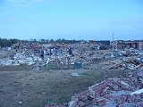
| F4 | SW of Madison Madison, Mississippi Madison is a city in Madison County, Mississippi, USA. The population was 14,691 at the 2000 census. The population is currently 16,930. It is part of the Jackson Metropolitan Statistical Area. It is currently the highest income city in the state... to S of Canton Canton, Mississippi Canton is a city in Madison County, Mississippi. The population was 12,911 at the 2000 census. It is the county seat of Madison County, and situated in the northern part of the metropolitan area surrounding the state capital, Jackson.... |
Madison Madison County, Mississippi -Demographics:As of the census of 2000, there were 74,674 people, 27,219 households, and 19,325 families residing in the county. The population density was 104 people per square mile . There were 28,781 housing units at an average density of 40 per square mile... |
1125 | 11.5 miles (18.4 km) |
2 deaths 84 homes and 10 mobile homes were severely damaged or destroyed with minor damage to 67 other homes and three mobile homes. One of the fatalities was a baby from a critically injured pregnant woman that was born just after the tornado and died shortly after birth. Worst of the damage occurred in the Fairfield subdivision of the Madison area. | |
| F1 | S of Bolatusha | Leake Leake County, Mississippi -Demographics:As of the census of 2000, there were 20,940 people, 7,611 households, and 5,563 families residing in the county. The population density was 36 people per square mile . There were 8,585 housing units at an average density of 15 per square mile... |
1225 | 0.2 miles (0.32 km) |
Damage limited to trees | |
| F0 | SW of Starkville Starkville, Mississippi -Demographics:As of the census of 2000, there were 21,869 people, 9,462 households, and 4,721 families residing in the city. The population density was 851.4 people per square mile . There were 10,191 housing units at an average density of 396.7 per square mile... |
Oktibbeha Oktibbeha County, Mississippi -National protected areas:*Noxubee National Wildlife Refuge *Tombigbee National Forest -Demographics:As of the census of 2000, there were 42,902 people, 15,945 households, and 9,264 families residing in the county. The population density was 94 people per square mile . There were 17,344 housing... |
1530 | 0.1 miles (0.16 km) |
Brief touchdown with no damage | |
| F1 | NW of Aubrey | Noxubee Noxubee County, Mississippi -Demographics:As of the census of 2000, there were 12,548 people, 4,470 households, and 3,222 families residing in the county. The population density was 18 people per square mile . There were 5,228 housing units at an average density of 8 per square mile... |
1610 | 8 miles (12.8 km) |
11 barns, 3 homes and a grain silo were damaged while three sheds and a small airplane hangar were destroyed | |
| F0 | NE of Middleton Middleton, Mississippi Middleton, Mississippi is an extinct town that was located west of the current geographical position of Winona, Mississippi.-History:Few travelers along U.S... |
Clarke Clarke County, Mississippi -Demographics:As of the census of 2000, there were 17,955 people, 6,978 households, and 5,024 families residing in the county. The population density was 26 people per square mile . There were 8,100 housing units at an average density of 12 per square mile... |
1715 | 0.5 miles (0.8 km) |
Minor damage to one home | |
| F0 | SW of Stonewall Stonewall, Mississippi Stonewall is a town in Clarke County, Mississippi, United States. The population was 1,149 at the 2000 census.-History:A cotton mill was established here in 1868 and was one of the first industries in Mississippi. The town was named after General T.J... |
Clarke Clarke County, Mississippi -Demographics:As of the census of 2000, there were 17,955 people, 6,978 households, and 5,024 families residing in the county. The population density was 26 people per square mile . There were 8,100 housing units at an average density of 12 per square mile... |
1802 | 0.3 miles (0.5 km) |
Damage to trees and power lines | |
| Kentucky Kentucky The Commonwealth of Kentucky is a state located in the East Central United States of America. As classified by the United States Census Bureau, Kentucky is a Southern state, more specifically in the East South Central region. Kentucky is one of four U.S. states constituted as a commonwealth... |
||||||
| F2 | W of Murray Murray, Kentucky Murray is a city in Calloway County, Kentucky, United States. The population was 17,741 at the 2010 census and has a micropolitan area population of 37,191. It is the 22nd largest city in Kentucky... |
Calloway Calloway County, Kentucky Calloway County is a county located in the U.S. state of Kentucky. It was formed in 1823. As of 2010, the population was 37,191. Its county seat is Murray, Kentucky. The county is named for Colonel Richard Callaway, one of the founders of Boonesborough... |
1247 | 11.5 miles (18.4 km) |
45 to 50 structures were damaged or destroyed including homes, barns and mobile homes. 4 people were injured | |
| Alabama Alabama Alabama is a state located in the southeastern region of the United States. It is bordered by Tennessee to the north, Georgia to the east, Florida and the Gulf of Mexico to the south, and Mississippi to the west. Alabama ranks 30th in total land area and ranks second in the size of its inland... |
||||||
| F3 | SE of Millport Millport, Alabama Millport is a town in Lamar County, Alabama, United States. At the 2000 census the population was 1,160.-Geography:Millport is located at .According to the U.S. Census Bureau, the town has a total area of , of which, of it is land and 0.18% is water.... to NE of Howard |
Pickens Pickens County, Alabama Pickens County is a county of the U.S. state of Alabama. As of 2010, the population was 19,746. Its county seat is Carrollton, and it is a prohibition, or dry county.-History:... , Lamar Lamar County, Alabama Lamar County is a county of the U.S. state of Alabama. Its name is in honor of Lucius Quintus Cincinnatus Lamar, member of the United States Senate from Mississippi. As of 2010 the population was 14,564... , Fayette Fayette County, Alabama Fayette County is a county of the U.S. state of Alabama. Its name is in honor of the Marquis de Lafayette , who aided General George Washington in the American Revolutionary War. As of 2010 the population was 17,241... , Walker Walker County, Alabama Walker County is a county of the U.S. state of Alabama.Its name is in honor of John Williams Walker, a member of the United States Senate. As of 2010 the population was 67,023... |
1655 | 38.9 miles (62.2 km) |
2 deaths Numerous structures were damaged or destroyed. Two occupants of a mobile home in Lamar County were killed and another person was injured | |
| F0 | NE of Moundville Moundville, Alabama Moundville is a town in Hale and Tuscaloosa Counties in the U.S. state of Alabama. At the 2000 census the population was 1,809. It is part of the Tuscaloosa Metropolitan Statistical Area. Moundville is known for its quintessential southern landscapes and Indian Mounds.-Geography:Moundville is... |
Hale Hale County, Alabama Hale County is a county of the U.S. state of Alabama. It is named in honor of Confederate officer Stephen Fowler Hale. As of 2010 the population was 15,760. Its county seat is Greensboro and it is part of the Tuscaloosa Metropolitan Statistical Area.... |
1702 | 0.2 miles (0.32 km) |
Minor damage to a nursery and mobile home | |
| F2 | Haleyville Haleyville, Alabama Haleyville is a city in Winston and Marion counties in the U.S. state of Alabama. Most of the city is located in Winston County, with a small portion of the western limits entering Marion County. Haleyville was originally named Davis Cross Roads, having been established at the crossroads of Byler... area |
Marion Marion County, Alabama Marion County is a county of the U.S. state of Alabama. Marion County was created by an act of the Alabama Territorial General Assembly on February 13, 1818. The county is located in the northwestern part of the state, bounded on the west by the state of Mississippi. It encompasses . Marion County... , Winston Winston County, Alabama Winston County is a county of the U.S. state of Alabama, formerly known as Hancock County before 1858.Its name is in honor of John A. Winston, the 15th Governor of Alabama. As of 2010, the population was 24,484. Its county seat is Double Springs.... |
1721 | 1.9 miles (3 km) |
Several buildings including a shopping mall were severely damaged. There were 13 injuries. | |
| F1 | SW of Samantha | Tuscaloosa Tuscaloosa County, Alabama Tuscaloosa County is a county of the U.S. state of Alabama.It is named in honor of the pre-Choctaw chief Tuskaloosa. In 2010, the population was 194,656... |
1739 | 2 miles (3.2 km) |
A few outbuildings were destroyed and one home sustained roof damage. | |
| F0 | S of Butler Butler, Alabama Butler is a town in and the county seat of Choctaw County, Alabama, United States. The population was 1,952 at the 2000 census, at which time it was a city.-History:... |
Choctaw Choctaw County, Alabama Choctaw County is a county of the U.S. state of Alabama. It was established on December 29, 1847 and named for the Choctaw tribe of American Indians. As of 2010 the population was 13,859. The county seat is Butler.- History :... |
1745 | 0.1 miles (0.16 km) |
Damage to trees and power lines | |
| F2 | Decatur Decatur, Alabama Decatur is a city in Limestone and Morgan Counties in the U.S. state of Alabama. The city, affectionately known as "The River City", is located in Northern Alabama on the banks of Wheeler Lake, along the Tennessee River. It is the largest city and county seat of Morgan County... area |
Lawrence Lawrence County, Alabama Lawrence County is a county of the U.S. state of Alabama, and is included in the Decatur Metropolitan Area, as well as the Huntsville-Decatur Combined Statistical Area. It was named after James Lawrence, a captain in the United States Navy from New Jersey. As of the 2010 census, the population was... |
1810 | 3.1 miles (5 km) |
Damage to several structures. 2 people were injured | |
| F2 | NW of Trinity Trinity, Alabama Trinity is a town in Morgan County, Alabama, and is included in the Decatur Metropolitan Area, as well as the Huntsville-Decatur Combined Statistical Area. As of the 2000 census, the population of the town is 1,841.-Geography:... |
Morgan Morgan County, Alabama Morgan County is the most populous county in the Decatur Metropolitan Area, and the second most populous county in the Huntsville-Decatur Combined Statistical Area in the U.S. State of Alabama. It was created by the Alabama Territorial legislature on February 6, 1818 from land acquired from the... |
1813 | 1.8 miles (2.9 km) |
Damage to several structures | |
| F0 | Cedarville area | Hale Hale County, Alabama Hale County is a county of the U.S. state of Alabama. It is named in honor of Confederate officer Stephen Fowler Hale. As of 2010 the population was 15,760. Its county seat is Greensboro and it is part of the Tuscaloosa Metropolitan Statistical Area.... |
1834 | 2.9 miles (4.6 km) |
A few structures were damaged | |
| F0 | S of Gilbertown Gilbertown, Alabama Gilbertown is a town in Choctaw County, Alabama, United States. At the 2000 census the population was 187.-Geography:Gilbertown is located at 31°52'36.034" North, 88°19'15.265" West .According to the U.S... |
Choctaw Choctaw County, Alabama Choctaw County is a county of the U.S. state of Alabama. It was established on December 29, 1847 and named for the Choctaw tribe of American Indians. As of 2010 the population was 13,859. The county seat is Butler.- History :... |
1835 | 0.1 miles (0.16 km) |
Damage to a few trees | |
| F0 | NW of Bucksville | Tuscaloosa Tuscaloosa County, Alabama Tuscaloosa County is a county of the U.S. state of Alabama.It is named in honor of the pre-Choctaw chief Tuskaloosa. In 2010, the population was 194,656... |
1837 | 0.2 miles (0.32 km) |
Brief touchdown with no damage | |
| F0 | W of Rembert Rembert, Alabama Rembert, also known as Rembert Hills, is an unincorporated community in Marengo County, Alabama. Rembert had a post office at one time, but it no longer exists.-Geography:Rembert is located at and has an elevation of .... |
Marengo Marengo County, Alabama Marengo County is a county of the U.S. state of Alabama. It is named in honor of a battlefield near Turin, Italy, where the French defeated the Austrians on June 14, 1800. As of 2010 the population was 21,027... |
1856 | 0.6 miles (1 km) |
Trees and power lines were blown down | |
| F1 | W of Vinemount | Cullman Cullman County, Alabama Cullman County is a county of the U.S. state of Alabama. Its name is in honor of Colonel John G. Cullmann. As of 2010, the population was 80,406. Its county seat is the town of the same name, Cullman, Alabama. It is a "moist" county in terms of availablity of alcoholic beverages, which means... |
1859 | 2.1 miles (3.4 km) |
3 chicken barns were damaged or destroyed and a frame garage collapsed | |
| F0 | SE of Toxey Toxey, Alabama Toxey is a town in Choctaw County, Alabama, United States. At the 2000 census the population was 152.-Geography:Toxey is located at 31°54'49.118" North, 88°18'30.485" West .According to the U.S... |
Choctaw Choctaw County, Alabama Choctaw County is a county of the U.S. state of Alabama. It was established on December 29, 1847 and named for the Choctaw tribe of American Indians. As of 2010 the population was 13,859. The county seat is Butler.- History :... |
1900 | 0.1 miles (0.16 km) |
Minor roof damage to some structures | |
| F0 | SW of Good Hope Good Hope, Alabama Good Hope is a town in Cullman County, Alabama, United States. As of the 2000 census, the population of the town is 1,966.-Geography:Good Hope is located at 34°6'32" North, 86°52'2" West .According to the U.S... |
Cullman Cullman County, Alabama Cullman County is a county of the U.S. state of Alabama. Its name is in honor of Colonel John G. Cullmann. As of 2010, the population was 80,406. Its county seat is the town of the same name, Cullman, Alabama. It is a "moist" county in terms of availablity of alcoholic beverages, which means... |
1902 | 0.2 miles (0.32 km) |
A few trees were blown down | |
| F4 | SE of Oneonta Oneonta, Alabama Oneonta is a city in Blount County, Alabama, United States. At the 2000 census the population was 5,576. The city is the county seat of Blount County... to SE of Altoona Altoona, Alabama Altoona is a town in Etowah County in the U.S. state of Alabama. It is part of the Gadsden Metropolitan Statistical Area. At the 2000 census the population was 984. According to the 2005 U.S. Census estimates, the town had a population of 970. -Geography:Altoona is located at .According to the U.S... |
Blount Blount County, Alabama Blount County is a county located in the U.S. state of Alabama. As of the 2010 United States Census, the population was 57,322. Its county seat is Oneonta.Blount County is a dry county.-History:... , Etowah Etowah County, Alabama Etowah County is a county of the U.S. state of Alabama. Its name is from the Cherokee language, which means "edible tree". It is the center of the Gadsden Metropolitan Area which includes Etowah and Cherokee Counties. As of 2010 the population was 104,430. Its county seat is Gadsden... |
1919 | 10.1 miles (16.2 km) |
22 people were injured. One frame house was completely destroyed while several heavy vehicles or equipment such as bulldozers, dump trunks and storage containers were rolled over or moved a certain distance. Several other homes, one church, one pole-barn building and trailers were damaged or destroyed | |
| F2 | NE of Trussville Trussville, Alabama Trussville is a city in Jefferson and St. Clair counties in the U.S. state of Alabama. The population was 19,933 at the 2010 census. Trussville was ranked as number 56 out of 100 in Money Magazines Best Places to Live 2005.-Geography:... to E of Springville Springville, Alabama Springville is a town in St. Clair County, Alabama, United States. At the 2000 census the population was 2,521.-Geography:Springville is located at .According to the U.S... |
Jefferson Jefferson County, Alabama Jefferson County is the most populous county in the U.S. state of Alabama, with its county seat being located in Birmingham.As of the 2010 U.S. Census, the population of Jefferson County was 658,466... , St. Clair St. Clair County, Alabama St. Clair County is a county of the U.S. state of Alabama.It is a part of the Birmingham–Hoover–Cullman Combined Statistical Area. Its name is in honor of General Arthur St... |
1931 | 13.4 miles (21.4 km) |
Damage to a sports complex, several homes and mobile homes. One person was injured. | |
| F2 | SE of Morgan City Morgan City, Alabama Morgan City is an unincorporated community located in Morgan County, Alabama, and is included in the Huntsville-Decatur Combined Statistical Area, as well as the Decatur Metropolitan Area. It's a small city.... |
Marshall Marshall County, Alabama Marshall County is a county of the U.S. state of Alabama, and is included in the Huntsville-Decatur Combined Statistical Area. Its name is in honor of John Marshall, famous Chief Justice of the United States. As of 2010 the population was 93,019... |
1941 | 2 miles (3.2 km) |
10 to 15 mobile homes, a hangar, two hunting cabins and several outbuildings and barns were destroyed while a few homes also sustained damage. 7 people were injured | |
| F2 | W of New Hope New Hope, Alabama New Hope is a city in Madison County, Alabama, United States, and is included in the Huntsville-Decatur Combined Statistical Area. As of the 2000 census, the population is 2,539.-History:... |
Madison Madison County, Alabama Madison County is a county of the U.S. state of Alabama, and is a major part of the Huntsville Metropolitan Area.It is also included in the merged Huntsville-Decatur Combined Statistical Area. The county is named in honor of James Madison, fourth President of the United States of America, and the... |
1950 | 2.6 miles (4.2 km) |
Several mobile homes were demolished while several businesses and 21 were damaged or destroyed. | |
| F2 | SW of Pine Ridge Pine Ridge, Alabama Pine Ridge is a town in DeKalb County, Alabama, United States. At the 2000 census the population was 243.-Geography:Pine Ridge is located at .According to the U.S. Census Bureau, the town has a total area of , all of it land.... |
DeKalb DeKalb County, Alabama As of the 2010 Census DeKalb County had a population of 71,109. The median age was 37.5. The racial and ethnic makeup of the population was 81.6% non-Hispanic white, 1.5% African American, 1.4% Native American, 0.3% Asian, 0.2% Pacific Islander , 9.9% from some other race, 2.2% reporting two or... |
2025 | 7.1 miles (11.4 km) |
Several chickens barns, a cinder-block building were damaged and a trailer home was destroyed | |
| F2 | NE of Sand Rock Sand Rock, Alabama Sand Rock is a town in Cherokee and DeKalb Counties in the U.S. state of Alabama, United States. At the 2000 census the population was 509.-Geography:Sand Rock is located at 34°13'57.115" North, 85°46'13.516" West .... |
Cherokee Cherokee County, Alabama Cherokee County, Alabama is a county of the U.S. state of Alabama. It is named for the Cherokee tribe. As of 2010 the population was 25,989. Its county seat is Centre and it is a prohibition or dry county.- History :... |
2101 | 8.2 miles (13.1 km) |
2 deaths The fatalities were from a demolished mobile home. Several other structures were damaged and 4 people were injured. | |
| F2 | N of Pell City Pell City, Alabama Pell City is a city in St. Clair County, Alabama, United States. The city is the county seat of St. Clair County along with Ashville. At the 2000 census the population was 9,565. At the 2010 census, the city-limit population jumped to 12,695. -Geography:... |
St. Clair St. Clair County, Alabama St. Clair County is a county of the U.S. state of Alabama.It is a part of the Birmingham–Hoover–Cullman Combined Statistical Area. Its name is in honor of General Arthur St... |
2110 | 4.5 miles (7.2 km) |
The tornado did damage to an EMA/911 office building as well as its communication tower. Several structures in downtown Pell City and its industrial park suffered minor to moderate damage. A few homes also sustained damaged and two people were injured. | |
| F2 | Sylacauga Sylacauga, Alabama Sylacauga is a city in Talladega County, Alabama, United States. At the 2000 census the population was 12,616.Nicknames for Sylacauga include: "The Marble City," "Buzzard's Roost" and "Sly Town".... area |
Talladega Talladega County, Alabama Talladega County is a county of the U.S. state of Alabama. Talladega is a Muscogee Native American word derived from TVLVTEKE, which means "border town." As of 2010, the population was 82,291... |
2142 | 3.1 miles (5 km) |
40 to 50 homes were damaged while 10 mobile homes and several outbuildings and sheds were destroyed. 15 people were injured. | |
| F1 | SW of Marbury Marbury, Alabama Marbury an unincorporated community in Autauga County, Alabama, United States.-Geography:Marbury is located at . It lies 522 feet above sea level.-Education:... |
Autauga Autauga County, Alabama Autauga County is a county in the U.S. state of Alabama. As of the 2010 census the population was 54,571. Its county seat is Prattville.Autauga County is part of the Montgomery Metropolitan Statistical Area.-History:... |
2154 | 9.8 miles (15.7 km) |
A trailer home, two trailers and a shed were destroyed while several homes and mobile homes were damaged | |
| F2 | SE of Sycamore | Talladega Talladega County, Alabama Talladega County is a county of the U.S. state of Alabama. Talladega is a Muscogee Native American word derived from TVLVTEKE, which means "border town." As of 2010, the population was 82,291... |
2159 | 9.1 miles (14.6 km) |
Several homes were damaged while 6 mobile homes, several outbuildings and barns were destroyed | |
| F1 | SW of Jacksonville Jacksonville, Alabama Jacksonville is a city in Calhoun County, Alabama, United States. which is a 49% increase since 2000. It is included in the Anniston-Oxford Metropolitan Statistical Area... |
Calhoun Calhoun County, Alabama Calhoun County is a county in the U.S. state of Alabama. Its name is in honor of John C. Calhoun, famous member of the United States Senate from South Carolina. As of 2010 the population was 118,572. It is included in the Anniston-Oxford Metropolitan Statistical Area... |
2203 | 7.7 miles (12.3 km) |
10 to 20 homes were damaged while several barns and outbuildings were destroyed. 5 people were injured due to flying debris. | |
| F0 | W of Evergreen Evergreen, Alabama Evergreen is a city in Conecuh County, Alabama, United States. As of the 2010 census the population was 3,944. The city is the county seat of Conecuh County.-History:Early settlers to the area came from Georgia and South Carolina beginning in 1818... |
Conecuh Conecuh County, Alabama -2010:Whereas according to the 2010 U.S. Census Bureau:*51.3% White*46.5% Black*0.3% Native American*0.1% Asian*0.0% Native Hawaiian or Pacific Islander*1.0% Two or more races*1.2% Hispanic or Latino -2000:... |
2242 | 0.1 miles (0.16 km) |
Damage to trees and power lines | |
| F0 | SW of Georgiana Georgiana, Alabama Georgiana is a town in Butler County, Alabama, United States. As of the 2000 census, the population of the town was 1,737.-Geography:Georgiana is located at 31°38'24.313" North, 86°44'21.991" West .According to the U.S... |
Butler Butler County, Alabama Butler County is a county of the U.S. state of Alabama. Its name is in honor of Captain William Butler, who was born in Virginia and fought in the Creek War, and who was killed in May 1818. As of 2010 the population was 20,947... |
2308 | 3 miles (4.8 km) |
Minor structural damage to a church | |
| F1 | NE of Barfield | Clay Clay County, Alabama Clay County is a county of the US state of Alabama. Its name is in honor of Henry Clay, famous American statesman, member of the United States Senate from Kentucky and United States Secretary of State in the 19th century. As of 2010 the population was 13,932... , Randolph Randolph County, Alabama Randolph County is a county of the U.S. state of Alabama.Its name is in honor of John Randolph, a member of the United States Senate from Virginia. As of 2010, the population was 22,913. Its county seat is Wedowee... |
2310 | 6.1 miles (9.8 km) |
A chapel and several barns suffered extensive damage with some barns being destroyed | |
| F1 | S of McKenzie McKenzie, Alabama McKenzie is a town in Butler and Conecuh counties in the U.S. state of Alabama. The population was 644 at the 2000 census.-Geography:McKenzie is located at .... |
Butler Butler County, Alabama Butler County is a county of the U.S. state of Alabama. Its name is in honor of Captain William Butler, who was born in Virginia and fought in the Creek War, and who was killed in May 1818. As of 2010 the population was 20,947... |
2342 | 6 miles (9.6 km) |
A mobile home was destroyed, its three occupants being injured. | |
| F0 | SW of Garland | Butler Butler County, Alabama Butler County is a county of the U.S. state of Alabama. Its name is in honor of Captain William Butler, who was born in Virginia and fought in the Creek War, and who was killed in May 1818. As of 2010 the population was 20,947... |
0030 | 0.1 miles (0.16 km) |
Damage limited to trees | |
| F0 | Brewton Brewton, Alabama Brewton is a city in Escambia County, Alabama, United States. At the 2000 census the population was 5,498. The city is the county seat of Escambia County.-History:... area |
Escambia Escambia County, Alabama -2010:Whereas according to the 2010 U.S. Census Bureau:*62.1% White*31.9% Black*4.4% Native American*0.2% Asian*0.0% Native Hawaiian or Pacific Islander*1.5% Two or more races*1.9% Hispanic or Latino -2000:... |
0110 | 0.1 miles (0.16 km) |
Minor roof damage to a few homes | |
| F0 | NW of River Falls River Falls, Alabama River Falls is a town in Covington County, Alabama, United States. At the 2000 census the population was 616.-Geography:River Falls is located about 7 kilometers northwest of Andalusia, the county seat, at . According to the U.S... |
Covington Covington County, Alabama Covington County, Alabama, is a county of the U.S. state of Alabama. Its name is in honor of Brigadier General Leonard Covington of Maryland. As of 2010 the population was 37,765... |
0128 | 0.1 miles (0.16 km) |
Damage to trees and power lines | |
| F0 | E of Rose Hill | Covington Covington County, Alabama Covington County, Alabama, is a county of the U.S. state of Alabama. Its name is in honor of Brigadier General Leonard Covington of Maryland. As of 2010 the population was 37,765... |
0230 | 0.2 miles (0.32 km) |
Damage limited to trees | |
| F0 | SW of Ansley | Pike Pike County, Alabama Pike County is a county of the U.S. state of Alabama. Its name is in honor of General Zebulon Pike, of New Jersey, an explorer who led an expedition to southern Colorado and discovered Pikes Peak in 1806. As of 2010 the population was 32,899. Its county seat is Troy.- History :In 1819 the State... |
0242 | 0.2 miles (0.32 km) |
Damage limited to trees | |
| F1 | N of Tarentum | Pike Pike County, Alabama Pike County is a county of the U.S. state of Alabama. Its name is in honor of General Zebulon Pike, of New Jersey, an explorer who led an expedition to southern Colorado and discovered Pikes Peak in 1806. As of 2010 the population was 32,899. Its county seat is Troy.- History :In 1819 the State... |
0327 | 11.8 miles (18.9 km) |
Moderate to significant roof damage to a few homes | |
| F1 | Daleville Daleville, Alabama Daleville is a city in Dale County, Alabama, United States. At the 2000 census the population was 4,653. It is part of the Enterprise–Ozark Micropolitan Statistical Area. The city's nickname is "Gateway to Fort Rucker", as this U.S. Army post is located just north of town... area |
Dale Dale County, Alabama Dale County is a county of the U.S. state of Alabama. Its name is in honor of General Samuel Dale. As of the 2010 census the population was 50,251... |
0612 | 2 miles (3.2 km) |
Two restaurants and two industrial buildings were destroyed. An Inn and Loundge, maintenance buildings, one aircraft, 25 businesses, a church, a gas station, two supermarkets, a bank and several homes. 25 people inside the Lounge were injured. | |
| F1 | S of Ewell | Dale Dale County, Alabama Dale County is a county of the U.S. state of Alabama. Its name is in honor of General Samuel Dale. As of the 2010 census the population was 50,251... |
0630 | 0.1 miles (0.16 km) |
A double mobile home was destroyed injuring its two occupants | |
| Georgia | ||||||
| F1 | E of Head River | Dade Dade County, Georgia Dade County is a county located in the U.S. state of Georgia. As of 2000, the population is 15,154. The 2007 Census Estimate shows a population of 16,098... |
2106 | 1.5 miles (2.4 km) |
A concrete block garage and a barn were destroyed with other structures with some damage. | |
| Indiana Indiana Indiana is a US state, admitted to the United States as the 19th on December 11, 1816. It is located in the Midwestern United States and Great Lakes Region. With 6,483,802 residents, the state is ranked 15th in population and 16th in population density. Indiana is ranked 38th in land area and is... |
||||||
| F1 | SE of Fenns to Gwynneville Gwynneville, Indiana Gwynneville is an unincorporated town in Hanover Township, Shelby County, Indiana.... |
Shelby Shelby County, Indiana As of the census of 2000, there were 43,445 people, 16,561 households, and 12,056 families residing in the county. The population density was 105 people per square mile . There were 17,633 housing units at an average density of 43 per square mile... |
0108 | 16 miles (25.6 km) |
Damage to 23 homes, an auto shop and 7 other businesses. | |
| Source: Tornado History Project Storm Data - November 24, 2001 | ||||||
See also
- List of North American tornadoes and tornado outbreaks
- Tornadoes of 2003Tornadoes of 2003This page documents the tornadoes and tornado outbreaks of 2003, primarily in the United States. Many tornadoes form in the U.S., although some events may take place internationally.-January:January had no tornadoes confirmed in the United States...