
Tornadoes of 2003
Encyclopedia
This page documents the tornado
es and tornado outbreak
s of 2003, primarily in the United States
. Many tornadoes form in the U.S., although some events may take place internationally.
in the northwestern Bandundu Province
of the Democratic Republic of the Congo
. Over 4,000 people were injured, 217 seriously.
, Pakistan
. More than 80 structures were destroyed, and many livestock were killed as well.
Another tornado struck the next day near Lahore
in eastern Pakistan
, killing two people and injuring 150. Four-hundred homes were destroyed in four villages.
(FEMA) disbursed over $8.4 million in funds. Additionally, a class F1 tornado struck North Miami Beach
and caused damage to trees and roofs, but no injuries were reported.
NWS report
of tornado outbreak
s that occurred from May 3 to May 11. Tornadoes began occurring over the affected area on April 30, but the most prolific continuous period was the seven day period of May 4-10. There were 401 tornado
reports in 19 states and one Canadian province, 1,587 reports of large hail
, and 740 reports of wind
damage. More severe weather
broke out this week alone than any other week in U.S. history, though comparable events occurred in May 1917, 1930, and 1949 before the modern era of tornado detection. There was a severe weather outbreak every day during the week. There were 48 people killed by the tornadoes, and damages totaled nearly $1 billion.
The main meteorological factor for this series of tornado outbreak
s was the presence of a persistent 500 mb trough
over the western United States
, coupled with a series of shortwave disturbances which propagated through the central
and eastern United States
. These shortwaves provided a mechanism for the deepening of surface low pressure area
s, which followed the upper level
flow from southwest to northeast. The cyclones induced a strong north to southeasterly flow in the low levels of the atmosphere (1000 mb, 850 mb) off the Gulf of Mexico
. This persistent flow provided an abundance of warm, moist maritime tropical
air in the central and eastern US.
of Bangladesh
.
, Australia
, damaging more than 50 houses on a 7 km path.
Hail to the size of volleyballs fell in Aurora, NE on this day with another storm to the south producing tornadoes. 1 person died from a tornado and another died the next night due to a tornado. The largest hailstone ever measured, 17.8 cm (7.0 in) in diameter with a 47.6 cm (18.75 in) circumference.
June 24
Around 5:00 pm a large F4
tornado touched down near Huron, South Dakota
ripping through the rural farmland before completely annihilating the town of Manchester
. The town of Manchester since then has become a ghost town.
Around 3:20pm, an F1
tornado touched down in Kinzua Bridge State Park
and destroyed the 103 year old Kinzua Bridge
.
At about 7:30pm, a long tracked supercell thunderstorm spawned a tornado over the Mid Hudson Valley of New York and continued into Vermont, with a total discontinuous track of 61 miles. It had multiple vortices at one point and at its strongest over Kinderhook Lake was rated an F2. A barn was completely destroyed and its contents thrown into Kinderhook Lake. The tornado also picked up a trailer home and smashed it to the ground, causing severe injuries to the woman inside. This tornado continued into Vermont, causing severe tree damage as the parent thunderstorm started producing downbursts in and near the tornado track. A restaurant suffered damage as windows were blown out and part of the roof was peeled off. It finally lifted while in the Green Mountain State Forest after an hour and a half long rampage. Its width ranged from 50 to 150 yards. Damage was estimated at $1.7M.
An F1
tornado hit Ewing
and Lawrence
townships, in Mercer County
, New Jersey
. There were no fatalities, but there was widespread damage to homes. The tornado touched down in Ewing near Prospect Street, crossed Olden Avenue, and entered Lawrence Township near the Shabukunk Creek. In Lawrenceville, the tornado followed a path parallel to and slightly northwest of Princeton Pike. Olden Avenue in Ewing was closed for several days while debris and downed power poles were removed. Several retail stores at the Mercer Mall and the Nassau Park retail center were also damaged.
. No deaths or injuries were reported, and damage was relatively minor; damage to fencing and landscaping,roof damage to a trailer, and destruction of a patio and carport. The widely scattered nature of the damage supported the Fujita F0 classification. NWS report
A minor tornado hit near Inverleigh, Victoria
, Australia, causing severe damage to a farm.
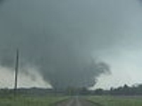
Tornado
A tornado is a violent, dangerous, rotating column of air that is in contact with both the surface of the earth and a cumulonimbus cloud or, in rare cases, the base of a cumulus cloud. They are often referred to as a twister or a cyclone, although the word cyclone is used in meteorology in a wider...
es and tornado outbreak
Tornado outbreak
While there is no single agreed upon definition, generally at least 6-10 tornadoes produced by the same synoptic scale weather system is considered a tornado outbreak. The tornadoes usually occur within the same day, or continue into the early morning hours of the succeeding day, and within the...
s of 2003, primarily in the United States
United States
The United States of America is a federal constitutional republic comprising fifty states and a federal district...
. Many tornadoes form in the U.S., although some events may take place internationally.
January
January had no tornadoes confirmed in the United States. It was only the fourth time since 1950 that an entire month went tornado-free.February 2
A tornado killed 17 people near the town of YumbiYumbi
Yumbi is a town and territory in Mai-Ndombe District, Democratic Republic of the Congo. It lies on the eastern bank of the Congo River. Yumbis population is approximately 30,000. On the 2nd of february 2003 a tornado killed 17 people in and near the town. Over 4,000 people were injured, 217...
in the northwestern Bandundu Province
Bandundu Province
Bandundu is one of the ten provinces of the Democratic Republic of the Congo. It borders the provinces of Kinshasa and Bas-Congo to the west, Équateur to the north, and Kasai-Occidental to the east. The provincial capital is also called Bandundu .In 1966, Bandundu was formed by merging the three...
of the Democratic Republic of the Congo
Democratic Republic of the Congo
The Democratic Republic of the Congo is a state located in Central Africa. It is the second largest country in Africa by area and the eleventh largest in the world...
. Over 4,000 people were injured, 217 seriously.
February 17–18
On the 17th, a tornado killed five people and injured 35 in Gadap TownGadap Town
Gadap Town is a town located in the northwestern part of Karachi with the Hub River on its western limits also forming the provincial border between Sindh and Balochistan, while to the north and east are Dadu District and the Kirthar Mountains....
, Pakistan
Pakistan
Pakistan , officially the Islamic Republic of Pakistan is a sovereign state in South Asia. It has a coastline along the Arabian Sea and the Gulf of Oman in the south and is bordered by Afghanistan and Iran in the west, India in the east and China in the far northeast. In the north, Tajikistan...
. More than 80 structures were destroyed, and many livestock were killed as well.
Another tornado struck the next day near Lahore
Lahore
Lahore is the capital of the Pakistani province of Punjab and the second largest city in the country. With a rich and fabulous history dating back to over a thousand years ago, Lahore is no doubt Pakistan's cultural capital. One of the most densely populated cities in the world, Lahore remains a...
in eastern Pakistan
Pakistan
Pakistan , officially the Islamic Republic of Pakistan is a sovereign state in South Asia. It has a coastline along the Arabian Sea and the Gulf of Oman in the south and is bordered by Afghanistan and Iran in the west, India in the east and China in the far northeast. In the north, Tajikistan...
, killing two people and injuring 150. Four-hundred homes were destroyed in four villages.
March
On 27 March, a series of six tornadoes stuck the south Florida area. including a Fujita class F2 that stuck the Liberty City neighborhood of Miami and caused one death and 14 injuries. The fatality was the first tornado-related death in Miami-Dade County since 1925. As a result of that tornado, the Federal Emergency Management AgencyFederal Emergency Management Agency
The Federal Emergency Management Agency is an agency of the United States Department of Homeland Security, initially created by Presidential Reorganization Plan No. 1 of 1978 and implemented by two Executive Orders...
(FEMA) disbursed over $8.4 million in funds. Additionally, a class F1 tornado struck North Miami Beach
North Miami Beach, Florida
North Miami Beach is a Miami suburban city in Miami-Dade County, Florida, United States. Originally named Fulford in 1926 after Captain William H. Fulford of the United States Coast Guard, the city was incorporated in 1927 as Fulford, but was renamed North Miami Beach in 1931. The population was...
and caused damage to trees and roofs, but no injuries were reported.
NWS report
May 3–11
The May 2003 Tornado outbreak sequence in the United States was a seriesTornado outbreak sequence
A tornado outbreak sequence is a period of continuous or nearly continuous high tornado activity consisting of a series of tornado outbreaks over multiple days with no or very few days lacking tornado outbreaks....
of tornado outbreak
Tornado outbreak
While there is no single agreed upon definition, generally at least 6-10 tornadoes produced by the same synoptic scale weather system is considered a tornado outbreak. The tornadoes usually occur within the same day, or continue into the early morning hours of the succeeding day, and within the...
s that occurred from May 3 to May 11. Tornadoes began occurring over the affected area on April 30, but the most prolific continuous period was the seven day period of May 4-10. There were 401 tornado
Tornado
A tornado is a violent, dangerous, rotating column of air that is in contact with both the surface of the earth and a cumulonimbus cloud or, in rare cases, the base of a cumulus cloud. They are often referred to as a twister or a cyclone, although the word cyclone is used in meteorology in a wider...
reports in 19 states and one Canadian province, 1,587 reports of large hail
Hail
Hail is a form of solid precipitation. It consists of balls or irregular lumps of ice, each of which is referred to as a hail stone. Hail stones on Earth consist mostly of water ice and measure between and in diameter, with the larger stones coming from severe thunderstorms...
, and 740 reports of wind
Wind
Wind is the flow of gases on a large scale. On Earth, wind consists of the bulk movement of air. In outer space, solar wind is the movement of gases or charged particles from the sun through space, while planetary wind is the outgassing of light chemical elements from a planet's atmosphere into space...
damage. More severe weather
Severe weather
Severe weather phenomena are weather conditions that are hazardous to human life and property.- Examples Include :Severe weather can occur under a variety of situations, but three characteristics are generally needed: a temperature or moisture boundary, moisture, and , instability in the...
broke out this week alone than any other week in U.S. history, though comparable events occurred in May 1917, 1930, and 1949 before the modern era of tornado detection. There was a severe weather outbreak every day during the week. There were 48 people killed by the tornadoes, and damages totaled nearly $1 billion.
The main meteorological factor for this series of tornado outbreak
Tornado outbreak
While there is no single agreed upon definition, generally at least 6-10 tornadoes produced by the same synoptic scale weather system is considered a tornado outbreak. The tornadoes usually occur within the same day, or continue into the early morning hours of the succeeding day, and within the...
s was the presence of a persistent 500 mb trough
Trough (meteorology)
A trough is an elongated region of relatively low atmospheric pressure, often associated with fronts.Unlike fronts, there is not a universal symbol for a trough on a weather chart. The weather charts in some countries or regions mark troughs by a line. In the United States, a trough may be marked...
over the western United States
Western United States
.The Western United States, commonly referred to as the American West or simply "the West," traditionally refers to the region comprising the westernmost states of the United States. Because the U.S. expanded westward after its founding, the meaning of the West has evolved over time...
, coupled with a series of shortwave disturbances which propagated through the central
Central United States
The Central United States is sometimes conceived as between the Eastern United States and Western United States as part of a three-region model, roughly coincident with the Midwestern United States plus the western and central portions of the Southern United States; the term is also sometimes used...
and eastern United States
Eastern United States
The Eastern United States, the American East, or simply the East is traditionally defined as the states east of the Mississippi River. The first two tiers of states west of the Mississippi have traditionally been considered part of the West, but can be included in the East today; usually in...
. These shortwaves provided a mechanism for the deepening of surface low pressure area
Low pressure area
A low-pressure area, or "low", is a region where the atmospheric pressure at sea level is below that of surrounding locations. Low-pressure systems form under areas of wind divergence which occur in upper levels of the troposphere. The formation process of a low-pressure area is known as...
s, which followed the upper level
Jet stream
Jet streams are fast flowing, narrow air currents found in the atmospheres of some planets, including Earth. The main jet streams are located near the tropopause, the transition between the troposphere and the stratosphere . The major jet streams on Earth are westerly winds...
flow from southwest to northeast. The cyclones induced a strong north to southeasterly flow in the low levels of the atmosphere (1000 mb, 850 mb) off the Gulf of Mexico
Gulf of Mexico
The Gulf of Mexico is a partially landlocked ocean basin largely surrounded by the North American continent and the island of Cuba. It is bounded on the northeast, north and northwest by the Gulf Coast of the United States, on the southwest and south by Mexico, and on the southeast by Cuba. In...
. This persistent flow provided an abundance of warm, moist maritime tropical
Airmass
In astronomy, air mass is the optical path length through Earth’s atmosphere for light from a celestial source. As it passes through the atmosphere, light is attenuated by scattering and absorption; the more atmosphere through which it passes, the greater the attenuation. Consequently, celestial...
air in the central and eastern US.
May 4 (Bangladesh)
At least 20 people were killed by a tornado in several remote villages in the Brahmanbaria DistrictBrahmanbaria District
Brahmanbaria is a district in east-central Bangladesh. It is a part of the Chittagong Division. It was part of greater Comilla District until 1984. Before 1830 the Sarail Pargana was a part of Mymensingh district...
of Bangladesh
Bangladesh
Bangladesh , officially the People's Republic of Bangladesh is a sovereign state located in South Asia. It is bordered by India on all sides except for a small border with Burma to the far southeast and by the Bay of Bengal to the south...
.
May 18
An F2 tornado struck Bendigo, VictoriaBendigo, Victoria
Bendigo is a major regional city in the state of Victoria, Australia, located very close to the geographical centre of the state and approximately north west of the state capital Melbourne. It is the second largest inland city and fourth most populous city in the state. The estimated urban...
, Australia
Australia
Australia , officially the Commonwealth of Australia, is a country in the Southern Hemisphere comprising the mainland of the Australian continent, the island of Tasmania, and numerous smaller islands in the Indian and Pacific Oceans. It is the world's sixth-largest country by total area...
, damaging more than 50 houses on a 7 km path.
June
June 22Hail to the size of volleyballs fell in Aurora, NE on this day with another storm to the south producing tornadoes. 1 person died from a tornado and another died the next night due to a tornado. The largest hailstone ever measured, 17.8 cm (7.0 in) in diameter with a 47.6 cm (18.75 in) circumference.
June 24
Around 5:00 pm a large F4
Fujita scale
The Fujita scale , or Fujita-Pearson scale, is a scale for rating tornado intensity, based primarily on the damage tornadoes inflict on human-built structures and vegetation...
tornado touched down near Huron, South Dakota
Huron, South Dakota
Huron is a city in Beadle County, South Dakota, United States. The population was 12,592 at the 2010 census. It is the county seat of Beadle County. Huron was the home of now-defunct Huron University since 1897. Huron is also the home of the South Dakota State Fair...
ripping through the rural farmland before completely annihilating the town of Manchester
Manchester, South Dakota
Manchester was a small unincorporated community in Kingsbury County in the east-central part of the U.S. state of South Dakota. On June 24, 2003, the town was completely annihilated by a large F4-rated tornado, and has since become a ghost town.-History:...
. The town of Manchester since then has become a ghost town.
July
July 21Around 3:20pm, an F1
Fujita scale
The Fujita scale , or Fujita-Pearson scale, is a scale for rating tornado intensity, based primarily on the damage tornadoes inflict on human-built structures and vegetation...
tornado touched down in Kinzua Bridge State Park
Kinzua Bridge State Park
Kinzua Bridge State Park is a Pennsylvania state park near Mount Jewett, in Hamlin and Keating Townships, McKean County, Pennsylvania in the United States. The park lies between U.S...
and destroyed the 103 year old Kinzua Bridge
Kinzua Bridge
The Kinzua Bridge or the Kinzua Viaduct was a railroad trestle that spanned Kinzua Creek in McKean County in the U.S. state of Pennsylvania...
.
At about 7:30pm, a long tracked supercell thunderstorm spawned a tornado over the Mid Hudson Valley of New York and continued into Vermont, with a total discontinuous track of 61 miles. It had multiple vortices at one point and at its strongest over Kinderhook Lake was rated an F2. A barn was completely destroyed and its contents thrown into Kinderhook Lake. The tornado also picked up a trailer home and smashed it to the ground, causing severe injuries to the woman inside. This tornado continued into Vermont, causing severe tree damage as the parent thunderstorm started producing downbursts in and near the tornado track. A restaurant suffered damage as windows were blown out and part of the roof was peeled off. It finally lifted while in the Green Mountain State Forest after an hour and a half long rampage. Its width ranged from 50 to 150 yards. Damage was estimated at $1.7M.
September
September 23An F1
Fujita scale
The Fujita scale , or Fujita-Pearson scale, is a scale for rating tornado intensity, based primarily on the damage tornadoes inflict on human-built structures and vegetation...
tornado hit Ewing
Ewing Township, New Jersey
-Demographics:As of the 2010 Census, there were 35,790 people, 13,171 households, and 7,980 families residing in the township. There were 13,926 housing units. The racial makeup of the township was 63.1% White, 27.6% African American, 0.3% Native American, 4.3% Asian, 0.0% Pacific Islander, 2.2%...
and Lawrence
Lawrence Township, Mercer County, New Jersey
Area residents often refer to all of Lawrence Township as Lawrenceville. Lawrenceville is a census-designated place and unincorporated area located within Lawrence Township...
townships, in Mercer County
Mercer County, New Jersey
As of the census of 2000, there were 350,761 people, 125,807 households, and 86,303 families residing in the county. The population density was 1,552 people per square mile . There were 133,280 housing units at an average density of 590 per square mile...
, New Jersey
New Jersey
New Jersey is a state in the Northeastern and Middle Atlantic regions of the United States. , its population was 8,791,894. It is bordered on the north and east by the state of New York, on the southeast and south by the Atlantic Ocean, on the west by Pennsylvania and on the southwest by Delaware...
. There were no fatalities, but there was widespread damage to homes. The tornado touched down in Ewing near Prospect Street, crossed Olden Avenue, and entered Lawrence Township near the Shabukunk Creek. In Lawrenceville, the tornado followed a path parallel to and slightly northwest of Princeton Pike. Olden Avenue in Ewing was closed for several days while debris and downed power poles were removed. Several retail stores at the Mercer Mall and the Nassau Park retail center were also damaged.
October
On 29 October, A category F0 tornado struck suburban Miami Gardens, FloridaMiami Gardens, Florida
Miami Gardens is a Miami suburban city located in Miami-Dade County, Florida. The city name comes from one of the major roadways through the area, Miami Gardens Drive. According to the 2010 U.S...
. No deaths or injuries were reported, and damage was relatively minor; damage to fencing and landscaping,roof damage to a trailer, and destruction of a patio and carport. The widely scattered nature of the damage supported the Fujita F0 classification. NWS report
December
December 21A minor tornado hit near Inverleigh, Victoria
Inverleigh, Victoria
Inverleigh is a small rural township in Victoria, Australia located west from the City of Geelong and from the state capital, Melbourne. At the 2006 census, Inverleigh had a population of 562....
, Australia, causing severe damage to a farm.
External links
- U.S. tornadoes in 2003 - Tornado History Project
- Tornado Project tornadoes 2003
- Storm Data "2003 Annual Summaries" (NCDC)