

Boone County, Arkansas
Encyclopedia
Boone County is a county
located in the U.S. state
of Arkansas
. As of the 2010 census
, the population was 36,903. The county seat
is Harrison
. Boone County is Arkansas's 62nd county, formed on April 9, 1869. Boone County is part of the Harrison Micropolitan Statistical Area
.
. Its original name was Boon, so named because the residents believed it would be a "boon" to all who settled there. The final e was added later.
According to the 2000 census, the county has a total area of 601.82 square miles (1,558.7 km²), of which 591.18 square miles (1,531.1 km²) (or 98.23%) is land and 10.64 square miles (27.6 km²) (or 1.77%) is water.
The county lies entirely within the Ozark Mountains. Rolling hills characterize the topography, with the more rugged Boston Mountains
lying just to the south. Isolated peaks of the Boston Mountain range are found in the south, including Boat Mountain, Pilot's Knob, and Gaither Mountain. Portions of Bull Shoals Lake
and Table Rock Lake
lie in the northeast and northwest corners, respectively. The Corps of Engineers operates and maintains popular campsites on the lakes at Lead Hill and Cricket Creek. Crooked Creek, popular with bass fishermen, winds through the county from south to east.
 As of the census
of 2000, there were 33,948 people, 13,851 households, and 9,861 families residing in the county. The population density
was 57 people per square mile (22/km²). There were 15,426 housing units at an average density of 26 per square mile (10/km²). The racial makeup of the county was 97.60% White
, 0.11% Black
or African American
, 0.71% Native American
, 0.32% Asian
, 0.02% Pacific Islander
, 0.34% from other races
, and 0.90% from two or more races. 1.06% of the population were Hispanic
or Latino
of any race.
There were 13,851 households out of which 30.70% had children under the age of 18 living with them, 59.50% were married couples
living together, 8.80% had a female householder with no husband present, and 28.80% were non-families. 25.60% of all households were made up of individuals and 11.20% had someone living alone who was 65 years of age or older. The average household size was 2.41 and the average family size was 2.88.
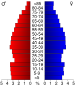
In the county the population was spread out with 23.90% under the age of 18, 8.20% from 18 to 24, 26.50% from 25 to 44, 24.70% from 45 to 64, and 16.70% who were 65 years of age or older. The median age was 39 years. For every 100 females there were 93.10 males. For every 100 females age 18 and over, there were 89.70 males.
The median income for a household in the county was $29,988, and the median income for a family was $34,974. Males had a median income of $27,114 versus $19,229 for females. The per capita income
for the county was $16,175. About 10.70% of families and 14.80% of the population were below the poverty line, including 19.00% of those under age 18 and 12.90% of those age 65 or over.
Batavia Township
Bear Creek Township (former)
Bellefonte Township (includes population of the town of Bellefonte
and in recent decades a part of the city of Harrison
)
Blythe Township (in 1910, included the area of the incorporated town of Zinc
)
Bryan Township
Carrollton Township (Between 1920 and 1980, the population of Boone County's Carrollton Township included the total population of the town of Alpena
, even though Alpena is in both Boone County and in parts of two townships in Carroll County. Starting in 2000, the US Census broke the population of Alpena down by township.)
Crooked Creek Township (former)
Elixir Township (population includes incorporated town of Bergman
)
Elmwood Township (former)
Ewing Township
Gaither Township
Harrison Township (This is a former township that included the former town of Harrison. As of 2011, there are townships of North Harrison and South Harrison with a city of Harrison
which overlays areas of a number of townships.)
Jackson Township (part of the city of Harrison
overlays Jackson Township according to the 1980 US Census going forward)
Jefferson Township (area includes the incorporated town of Valley Springs
)
Lee Township
Long Creek Township
North Harrison Township (includes part of the city of Harrison
and unincorporated areas)
Olvey Township
Omaha Township (includes the population of the incorporated town of Omaha
)
Prairie Township (area includes the incorporated town of Everton
)
South Harrison Township (includes part of the city of Harrison
and unincorporated areas)
Sugar Loaf Township (includes the incorporated city of Diamond City
and the incorporated towns of Lead Hill
and South Lead Hill
)
Summit Township
Washington Township (former)
Young Township (former)
Zinc Township (includes the population of the incorporated town of Zinc
from 1920 forward)
County (United States)
In the United States, a county is a geographic subdivision of a state , usually assigned some governmental authority. The term "county" is used in 48 of the 50 states; Louisiana is divided into parishes and Alaska into boroughs. Parishes and boroughs are called "county-equivalents" by the U.S...
located in the U.S. state
U.S. state
A U.S. state is any one of the 50 federated states of the United States of America that share sovereignty with the federal government. Because of this shared sovereignty, an American is a citizen both of the federal entity and of his or her state of domicile. Four states use the official title of...
of Arkansas
Arkansas
Arkansas is a state located in the southern region of the United States. Its name is an Algonquian name of the Quapaw Indians. Arkansas shares borders with six states , and its eastern border is largely defined by the Mississippi River...
. As of the 2010 census
United States Census, 2010
The Twenty-third United States Census, known as Census 2010 or the 2010 Census, is the current national census of the United States. National Census Day was April 1, 2010 and is the reference date used in enumerating individuals...
, the population was 36,903. The county seat
County seat
A county seat is an administrative center, or seat of government, for a county or civil parish. The term is primarily used in the United States....
is Harrison
Harrison, Arkansas
Harrison is a city in Boone County, Arkansas, United States. It is the county seat. According to 2007 Census Bureau estimates, the population of the city was 13,108. Boone County was organized in 1869, during reconstruction after the civil war. Harrison was platted and made the county seat. It is...
. Boone County is Arkansas's 62nd county, formed on April 9, 1869. Boone County is part of the Harrison Micropolitan Statistical Area
Harrison micropolitan area
The Harrison Micropolitan Statistical Area, as defined by the United States Census Bureau, is an area consisting of two counties in the U.S. state of Arkansas, anchored by the city of Harrison....
.
History
Boone County was formed from the eastern portion of Carroll County. Contrary to popular belief, it was not named for Daniel BooneDaniel Boone
Daniel Boone was an American pioneer, explorer, and frontiersman whose frontier exploits mad']'e him one of the first folk heroes of the United States. Boone is most famous for his exploration and settlement of what is now the Commonwealth of Kentucky, which was then beyond the western borders of...
. Its original name was Boon, so named because the residents believed it would be a "boon" to all who settled there. The final e was added later.
Geography
The county is located in the northwest portion of the state, and borders Missouri to the north.According to the 2000 census, the county has a total area of 601.82 square miles (1,558.7 km²), of which 591.18 square miles (1,531.1 km²) (or 98.23%) is land and 10.64 square miles (27.6 km²) (or 1.77%) is water.
The county lies entirely within the Ozark Mountains. Rolling hills characterize the topography, with the more rugged Boston Mountains
Boston Mountains
The Boston Mountains area is a high and deeply dissected plateau located in northern Arkansas and eastern Oklahoma. The Oklahoma portion of the range is locally referred to as the Cookson Hills. The rocks of the region are essentially little disturbed, flat-lying sedimentary layers of the Paleozoic...
lying just to the south. Isolated peaks of the Boston Mountain range are found in the south, including Boat Mountain, Pilot's Knob, and Gaither Mountain. Portions of Bull Shoals Lake
Bull Shoals Lake
Bull Shoals Lake is an artificial lake or reservoir in the Ozark Mountains of northern Arkansas and southern Missouri. It has hundreds of miles of lake arms and coves perfect for boating, water sports, swimming, and fishing...
and Table Rock Lake
Table Rock Lake
Table Rock Lake is an artificial lake or reservoir in The Ozarks of southwestern Missouri and northwestern Arkansas. It is impounded by Table Rock Dam constructed in 1954-1958 on the White River by the U.S. Army Corps of Engineers. It is one of the tourist draws for the nearby town of Branson,...
lie in the northeast and northwest corners, respectively. The Corps of Engineers operates and maintains popular campsites on the lakes at Lead Hill and Cricket Creek. Crooked Creek, popular with bass fishermen, winds through the county from south to east.
Major highways
 U.S. Highway 65
 U.S. Highway 62
 U.S. Highway 412
- U.S. Route 65 Business (Harrison, Arkansas)
 Arkansas Highway 7
 Arkansas Highway 14Arkansas Highway 14Arkansas Highway 14 is a designation for two east–west state highway in Arkansas. The primary route from the original 1926 Arkansas state highway numbering runs from Table Rock Lake east to Interstate 555/U.S. Route 63...
 Arkansas Highway 43
 Arkansas Highway 123Arkansas Highway 123-Boone County:Arkansas Highway 123 is a brief state highway in Boone County, Arkansas. It runs vertically from Salmon Lane north to U.S. Route 65 near Harrison.-Johnson/Pope/Newton Counties:...
 Arkansas Highway 206Arkansas Highway 206Arkansas Highway 206 is a designation for two east–west state highways in north Arkansas. The longer segment of runs from Highway 43 in Boone County to the Marion County line. A shorter segment of runs east from Highway 14 to Marion County Route 6022. Neither route has any spur or business...
 Arkansas Highway 281Arkansas Highway 281Arkansas Highway 281 is a state highway in Boone County, Arkansas. It is made up of two segments, which are separated by of Arkansas Highway 14.-Route description:...
 Arkansas Highway 392
 Arkansas Highway 396Arkansas Highway 396Arkansas Highway 396 is a short state highway in Boone County. It splits west from U.S. Route 65 north of Burlington.-Major intersections:...
 Arkansas Highway 397
 Arkansas Highway 980Arkansas Highway 980Arkansas Highway 980 is a state highway designation for all state maintained airport roads in Arkansas.-Section 1:Arkansas Highway 980 is a state highway of in Arkansas County. It connects Arkansas Highway 130 with Almyra Municipal Airport in Almyra....
Adjacent counties
- Taney CountyTaney County, MissouriTaney County is a county located in Southwest Missouri in the United States. As of the 2000 U.S. Census, the county's population was 39,703. In the 2010 census the counties population was 51,675 Its county seat is Forsyth....
, MissouriMissouriMissouri is a US state located in the Midwestern United States, bordered by Iowa, Illinois, Kentucky, Tennessee, Arkansas, Oklahoma, Kansas and Nebraska. With a 2010 population of 5,988,927, Missouri is the 18th most populous state in the nation and the fifth most populous in the Midwest. It...
(north) - Marion County (east)
- Searcy County (southeast)
- Newton CountyNewton County, ArkansasNewton County is a county located in the U.S. state of Arkansas. As of 2010, the population is 8,330. The county seat is Jasper. Newton County is Arkansas's 46th county, formed on December 14, 1842, and named for Thomas W. Newton, an Arkansas Congressman...
(south) - Carroll County (west)
Demographics
Census
A census is the procedure of systematically acquiring and recording information about the members of a given population. It is a regularly occurring and official count of a particular population. The term is used mostly in connection with national population and housing censuses; other common...
of 2000, there were 33,948 people, 13,851 households, and 9,861 families residing in the county. The population density
Population density
Population density is a measurement of population per unit area or unit volume. It is frequently applied to living organisms, and particularly to humans...
was 57 people per square mile (22/km²). There were 15,426 housing units at an average density of 26 per square mile (10/km²). The racial makeup of the county was 97.60% White
Race (United States Census)
Race and ethnicity in the United States Census, as defined by the Federal Office of Management and Budget and the United States Census Bureau, are self-identification data items in which residents choose the race or races with which they most closely identify, and indicate whether or not they are...
, 0.11% Black
Race (United States Census)
Race and ethnicity in the United States Census, as defined by the Federal Office of Management and Budget and the United States Census Bureau, are self-identification data items in which residents choose the race or races with which they most closely identify, and indicate whether or not they are...
or African American
Race (United States Census)
Race and ethnicity in the United States Census, as defined by the Federal Office of Management and Budget and the United States Census Bureau, are self-identification data items in which residents choose the race or races with which they most closely identify, and indicate whether or not they are...
, 0.71% Native American
Race (United States Census)
Race and ethnicity in the United States Census, as defined by the Federal Office of Management and Budget and the United States Census Bureau, are self-identification data items in which residents choose the race or races with which they most closely identify, and indicate whether or not they are...
, 0.32% Asian
Race (United States Census)
Race and ethnicity in the United States Census, as defined by the Federal Office of Management and Budget and the United States Census Bureau, are self-identification data items in which residents choose the race or races with which they most closely identify, and indicate whether or not they are...
, 0.02% Pacific Islander
Race (United States Census)
Race and ethnicity in the United States Census, as defined by the Federal Office of Management and Budget and the United States Census Bureau, are self-identification data items in which residents choose the race or races with which they most closely identify, and indicate whether or not they are...
, 0.34% from other races
Race (United States Census)
Race and ethnicity in the United States Census, as defined by the Federal Office of Management and Budget and the United States Census Bureau, are self-identification data items in which residents choose the race or races with which they most closely identify, and indicate whether or not they are...
, and 0.90% from two or more races. 1.06% of the population were Hispanic
Race (United States Census)
Race and ethnicity in the United States Census, as defined by the Federal Office of Management and Budget and the United States Census Bureau, are self-identification data items in which residents choose the race or races with which they most closely identify, and indicate whether or not they are...
or Latino
Race (United States Census)
Race and ethnicity in the United States Census, as defined by the Federal Office of Management and Budget and the United States Census Bureau, are self-identification data items in which residents choose the race or races with which they most closely identify, and indicate whether or not they are...
of any race.
There were 13,851 households out of which 30.70% had children under the age of 18 living with them, 59.50% were married couples
Marriage
Marriage is a social union or legal contract between people that creates kinship. It is an institution in which interpersonal relationships, usually intimate and sexual, are acknowledged in a variety of ways, depending on the culture or subculture in which it is found...
living together, 8.80% had a female householder with no husband present, and 28.80% were non-families. 25.60% of all households were made up of individuals and 11.20% had someone living alone who was 65 years of age or older. The average household size was 2.41 and the average family size was 2.88.
In the county the population was spread out with 23.90% under the age of 18, 8.20% from 18 to 24, 26.50% from 25 to 44, 24.70% from 45 to 64, and 16.70% who were 65 years of age or older. The median age was 39 years. For every 100 females there were 93.10 males. For every 100 females age 18 and over, there were 89.70 males.
The median income for a household in the county was $29,988, and the median income for a family was $34,974. Males had a median income of $27,114 versus $19,229 for females. The per capita income
Per capita income
Per capita income or income per person is a measure of mean income within an economic aggregate, such as a country or city. It is calculated by taking a measure of all sources of income in the aggregate and dividing it by the total population...
for the county was $16,175. About 10.70% of families and 14.80% of the population were below the poverty line, including 19.00% of those under age 18 and 12.90% of those age 65 or over.
Current Incorporated Cities and Towns
|
Everton, Arkansas Everton is a town in Boone County, Arkansas, United States. The population was 170 at the 2000 census. It is part of the Harrison Micropolitan Statistical Area.-Geography:Everton is located at .... Harrison, Arkansas Harrison is a city in Boone County, Arkansas, United States. It is the county seat. According to 2007 Census Bureau estimates, the population of the city was 13,108. Boone County was organized in 1869, during reconstruction after the civil war. Harrison was platted and made the county seat. It is... Lead Hill, Arkansas Lead Hill is a town in Boone County, Arkansas, United States. The population was 287 at the 2000 census. It is part of the Harrison Micropolitan Statistical Area.-Geography:Lead Hill is located at .... Omaha, Arkansas Omaha is a town in Boone County, Arkansas. As of the 2000 census the population stood at 165. It is a rural community located approximately 10 miles from Branson, Missouri and 15 miles from Harrison, Arkansas... |
South Lead Hill, Arkansas South Lead Hill is a town in Boone County, Arkansas, United States. The population was 88 at the 2000 census. It is part of the Harrison Micropolitan Statistical Area.-Geography:South Lead Hill is located at .... Valley Springs, Arkansas Valley Springs is a town in Boone County, Arkansas, United States. The population was 167 at the 2000 census. It is part of the Harrison Micropolitan Statistical Area.-Geography:Valley Springs is located at .... Zinc, Arkansas Zinc is a town in Boone County, Arkansas, United States. The population was only 76 at the 2000 census. It is part of the Harrison Micropolitan Statistical Area.-Geography:Zinc is located at .... |
Historical and/or Current Unincorporated Communities
- Batavia was a former town and is now an unincorporated community. In 1880, Roswell Underwood established the first post office in the former town. He named it Batavia after his hometown of Batavia, New York. The town was laid out in blocks. The first house on Main Street was built in 1912. Arkansas Highway 206 is where Main Street used to be located. The post office was closed in 1955. During its heyday, businesses included stores, hotels, a canning factory, a train depot, stockyards, mills, a corn gristmill, and a blacksmith shop. There was also a school and churches. By 1926, the passenger railroad stopped going through Batavia. While the community is bigger in terms of population and homes than it was as an incorporated town, the businesses are fewer. Batavia township still exists without any current incorporated towns inside of it.
- Bear Creek Springs
- Elixir was a town in the vicinity of many springs. It was nearby present day BergmanBergman, ArkansasBergman is a town in Boone County, Arkansas, United States. The population was 407 at the 2000 census. It is part of the Harrison Micropolitan Statistical Area.-Geography:Bergman is located at ....
. Heavy rains flooded the town in 1883, which was a major factor in its decline by 1892. In the 1880s, both Lead HillLead Hill, ArkansasLead Hill is a town in Boone County, Arkansas, United States. The population was 287 at the 2000 census. It is part of the Harrison Micropolitan Statistical Area.-Geography:Lead Hill is located at ....
and Elixir were expecting a railroad but none materialized. This also helped the town's decline. Although the town is gone, the township of Elixir remains and currently contains BergmanBergman, ArkansasBergman is a town in Boone County, Arkansas, United States. The population was 407 at the 2000 census. It is part of the Harrison Micropolitan Statistical Area.-Geography:Bergman is located at ....
.
- Keener was a town around one mile south of present day BergmanBergman, ArkansasBergman is a town in Boone County, Arkansas, United States. The population was 407 at the 2000 census. It is part of the Harrison Micropolitan Statistical Area.-Geography:Bergman is located at ....
. Keener was strong in the 1880s and had a population of about 1,000 people. But, Keener began to decline fast by 1892.
Townships
- Batavia
- Blythe
- Bryan
- Carrollton (AlpenaAlpena, ArkansasAlpena is a town in Boone and Carroll counties in the U.S. state of Arkansas. The population was 371 at the 2000 census.The Boone County portion of Alpena is part of the Harrison Micropolitan Statistical Area.-History:...
) - Elixir (BergmanBergman, ArkansasBergman is a town in Boone County, Arkansas, United States. The population was 407 at the 2000 census. It is part of the Harrison Micropolitan Statistical Area.-Geography:Bergman is located at ....
) - Ewing
- Gaither
- Jackson (HarrisonHarrison, ArkansasHarrison is a city in Boone County, Arkansas, United States. It is the county seat. According to 2007 Census Bureau estimates, the population of the city was 13,108. Boone County was organized in 1869, during reconstruction after the civil war. Harrison was platted and made the county seat. It is...
) - Jefferson (Valley SpringsValley Springs, ArkansasValley Springs is a town in Boone County, Arkansas, United States. The population was 167 at the 2000 census. It is part of the Harrison Micropolitan Statistical Area.-Geography:Valley Springs is located at ....
) - Lee
- Long Creek
- North Harrison (HarrisonHarrison, ArkansasHarrison is a city in Boone County, Arkansas, United States. It is the county seat. According to 2007 Census Bureau estimates, the population of the city was 13,108. Boone County was organized in 1869, during reconstruction after the civil war. Harrison was platted and made the county seat. It is...
) - Olvey
- Omaha (OmahaOmaha, ArkansasOmaha is a town in Boone County, Arkansas. As of the 2000 census the population stood at 165. It is a rural community located approximately 10 miles from Branson, Missouri and 15 miles from Harrison, Arkansas...
) - Prairie (EvertonEverton, ArkansasEverton is a town in Boone County, Arkansas, United States. The population was 170 at the 2000 census. It is part of the Harrison Micropolitan Statistical Area.-Geography:Everton is located at ....
) - South Harrison (HarrisonHarrison, ArkansasHarrison is a city in Boone County, Arkansas, United States. It is the county seat. According to 2007 Census Bureau estimates, the population of the city was 13,108. Boone County was organized in 1869, during reconstruction after the civil war. Harrison was platted and made the county seat. It is...
) - Sugar Loaf (Diamond CityDiamond City, ArkansasDiamond City is a city in Boone County, Arkansas, United States. The population was 730 at the 2000 census. It is part of the Harrison Micropolitan Statistical Area.-Geography:Diamond City is located at ....
, Lead HillLead Hill, ArkansasLead Hill is a town in Boone County, Arkansas, United States. The population was 287 at the 2000 census. It is part of the Harrison Micropolitan Statistical Area.-Geography:Lead Hill is located at ....
, South Lead HillSouth Lead Hill, ArkansasSouth Lead Hill is a town in Boone County, Arkansas, United States. The population was 88 at the 2000 census. It is part of the Harrison Micropolitan Statistical Area.-Geography:South Lead Hill is located at ....
) - Summit
- Zinc (ZincZinc, ArkansasZinc is a town in Boone County, Arkansas, United States. The population was only 76 at the 2000 census. It is part of the Harrison Micropolitan Statistical Area.-Geography:Zinc is located at ....
)
Population History by Township
The US Census lists population within a county by minor civil division (townships in the case of Arkansas). If an incorporated municipality is present within that township and is recognized by the US Census, the population of the portion of the incorporated municipality within the township lines is included in the township's population.Batavia Township
| Census | Population |
|---|---|
| 2000 | 851 |
| 1990 | 682 |
| 1980 | 272 |
| 1970 | 171 |
| 1960 | 231 |
| 1950 | 162 |
| 1940 | 312 |
| 1930 | 288 |
| 1920 | 270 |
| 1910 | 439 |
Bear Creek Township (former)
| Census | Population |
|---|---|
| 1950 | 291 |
| 1940 | 456 |
| 1930 | 421 |
| 1920 | 589 |
| 1910 | 435 |
| 1900 | 683 |
| 1890 | 856 |
| 1880 | 588 |
| 1870 | 314 |
| 1860 (area part of Carroll County at the time) | 297 |
Bellefonte Township (includes population of the town of Bellefonte
Bellefonte, Arkansas
Bellefonte is a town in Boone County, Arkansas, United States. The population was 400 at the 2000 census. It is part of the Harrison Micropolitan Statistical Area.-Geography:Bellefonte is located at ....
and in recent decades a part of the city of Harrison
Harrison, Arkansas
Harrison is a city in Boone County, Arkansas, United States. It is the county seat. According to 2007 Census Bureau estimates, the population of the city was 13,108. Boone County was organized in 1869, during reconstruction after the civil war. Harrison was platted and made the county seat. It is...
)
| Census | Population |
|---|---|
| 2000 | 2,234 |
| 1990 | 2,024 |
| 1980 | 1,860 |
| 1970 | 1,283 |
| 1960 | 909 |
| 1950 | 739 |
| 1940 | 773 |
| 1930 | 570 |
| 1920 | 629 |
| 1910 | 747 |
| 1900 | 850 |
| 1890 | 1,018 |
| 1880 | 1,379 |
Blythe Township (in 1910, included the area of the incorporated town of Zinc
Zinc, Arkansas
Zinc is a town in Boone County, Arkansas, United States. The population was only 76 at the 2000 census. It is part of the Harrison Micropolitan Statistical Area.-Geography:Zinc is located at ....
)
| Census | Population |
|---|---|
| 2000 | 266 |
| 1990 | 181 |
| 1980 | 235 |
| 1970 | 112 |
| 1960 | 139 |
| 1950 | 177 |
| 1940 | 205 |
| 1930 | 227 |
| 1920 | 281 |
| 1910 (see note above table) | 758 |
| 1900 | 865 |
| 1890 | 858 |
| 1880 | 489 |
Bryan Township
| Census | Population |
|---|---|
| 2000 | 1,006 |
| 1990 | 780 |
| 1980 | 903 |
| 1970 | 573 |
| 1960 | 305 |
| 1950 | 583 |
| 1940 | 357 |
| 1930 | 268 |
| 1920 | 334 |
| 1910 | 403 |
| 1900 | 416 |
Carrollton Township (Between 1920 and 1980, the population of Boone County's Carrollton Township included the total population of the town of Alpena
Alpena, Arkansas
Alpena is a town in Boone and Carroll counties in the U.S. state of Arkansas. The population was 371 at the 2000 census.The Boone County portion of Alpena is part of the Harrison Micropolitan Statistical Area.-History:...
, even though Alpena is in both Boone County and in parts of two townships in Carroll County. Starting in 2000, the US Census broke the population of Alpena down by township.)
| Census | Population |
|---|---|
| 2000 | 768 |
| 1990 | 777 |
| 1980 | 753 |
| 1970 | 648 |
| 1960 | 568 |
| 1950 | 665 |
| 1940 | 732 |
| 1930 | 812 |
| 1920 | 693 |
| 1910 | 664 |
| 1900 | 1,212 |
| 1890 | 1,129 |
| 1880 | 802 |
| 1870 | 577 |
Crooked Creek Township (former)
| Census | Population |
|---|---|
| 1930 | 96 |
| 1920 | 167 |
| 1910 | 283 |
| 1900 | 524 |
| 1890 | 1,082 |
| 1880 | 1,116 |
| 1870 | 646 |
| 1860 (area part of Carroll County at the time) | 1,020 |
| 1850 (area part of Carroll County at the time) | 539 |
Elixir Township (population includes incorporated town of Bergman
Bergman, Arkansas
Bergman is a town in Boone County, Arkansas, United States. The population was 407 at the 2000 census. It is part of the Harrison Micropolitan Statistical Area.-Geography:Bergman is located at ....
)
| Census | Population |
|---|---|
| 2000 | 2,304 |
| 1990 | 1,927 |
| 1980 | 1,573 |
| 1970 | 924 |
| 1960 | 527 |
| 1950 | 608 |
| 1940 | 679 |
| 1930 | 675 |
| 1920 | 691 |
| 1910 | 607 |
| 1900 | 679 |
| 1890 | 716 |
Elmwood Township (former)
| Census | Population |
|---|---|
| 1950 | 229 |
| 1940 | 236 |
| 1930 | 195 |
| 1920 | 209 |
Ewing Township
| Census | Population |
|---|---|
| 2000 | 389 |
| 1990 | 302 |
| 1980 | 270 |
| 1970 | not listed |
| 1960 | not listed |
| 1950 | 159 |
| 1940 | 231 |
| 1930 | 183 |
| 1920 | 223 |
| 1910 | 512 |
| 1900 | 612 |
| 1890 | 598 |
Gaither Township
| Census | Population |
|---|---|
| 2000 | 717 |
| 1990 | 653 |
| 1980 | 592 |
| 1970 | not listed |
| 1960 | not listed |
| 1950 | 228 |
| 1940 | 253 |
| 1930 | 254 |
| 1920 | 336 |
| 1910 | 453 |
| 1900 | 523 |
Harrison Township (This is a former township that included the former town of Harrison. As of 2011, there are townships of North Harrison and South Harrison with a city of Harrison
Harrison, Arkansas
Harrison is a city in Boone County, Arkansas, United States. It is the county seat. According to 2007 Census Bureau estimates, the population of the city was 13,108. Boone County was organized in 1869, during reconstruction after the civil war. Harrison was platted and made the county seat. It is...
which overlays areas of a number of townships.)
| Census | Population |
|---|---|
| 1930 | 4,836 |
| 1920 | 4,608 |
| 1910 | 2,743 |
| 1900 | 2,849 |
| 1890 | 2,240 |
| 1880 | 1,834 |
| 1870 | 826 |
Jackson Township (part of the city of Harrison
Harrison, Arkansas
Harrison is a city in Boone County, Arkansas, United States. It is the county seat. According to 2007 Census Bureau estimates, the population of the city was 13,108. Boone County was organized in 1869, during reconstruction after the civil war. Harrison was platted and made the county seat. It is...
overlays Jackson Township according to the 1980 US Census going forward)
| Census | Population |
|---|---|
| 2000 | 1,156 |
| 1990 | 839 |
| 1980 | 703 |
| 1970 | 526 |
| 1960 | 444 |
| 1950 | 485 |
| 1940 | 520 |
| 1930 | 363 |
| 1920 | 373 |
| 1910 | 401 |
| 1900 | 582 |
| 1890 | 717 |
| 1880 | 710 |
| 1870 | 320 |
| 1860 (area part of Carroll County at the time) | 571 |
Jefferson Township (area includes the incorporated town of Valley Springs
Valley Springs, Arkansas
Valley Springs is a town in Boone County, Arkansas, United States. The population was 167 at the 2000 census. It is part of the Harrison Micropolitan Statistical Area.-Geography:Valley Springs is located at ....
)
| Census | Population |
|---|---|
| 2000 | 1,187 |
| 1990 | 1,050 |
| 1980 | 858 |
| 1970 | 526 |
| 1960 | 388 |
| 1950 | 458 |
| 1940 | 524 |
| 1930 | 441 |
| 1920 | 502 |
| 1910 | 996 |
| 1900 | 1,147 |
| 1890 | 1,119 |
| 1880 | 987 |
| 1870 | 1,649 |
| 1860 (area part of Carroll County at the time) | 1,338 |
| 1850 (area part of Carroll County at the time) | 782 |
Lee Township
| Census | Population |
|---|---|
| 2000 | 1,510 |
| 1990 | 1,073 |
| 1980 | 978 |
| 1970 | 658 |
| 1960 | 531 |
| 1950 | 590 |
| 1940 | 623 |
| 1930 | 639 |
| 1920 | 694 |
| 1910 | 590 |
| 1900 | 806 |
| 1890 | 550 |
| 1880 | 288 |
Long Creek Township
| Census | Population |
|---|---|
| 2000 | 749 |
| 1990 | 586 |
| 1980 | 520 |
| 1970 | 419 |
| 1960 | 359 |
| 1950 | 388 |
| 1940 | 460 |
| 1930 | 460 |
| 1920 | 544 |
| 1910 | 542 |
| 1900 | 562 |
| 1890 | 518 |
| 1880 | 486 |
| 1870 | 214 |
| 1860 (area part of Carroll County at the time) | 503 |
| 1850 (area part of Carroll County at the time) | 294 |
North Harrison Township (includes part of the city of Harrison
Harrison, Arkansas
Harrison is a city in Boone County, Arkansas, United States. It is the county seat. According to 2007 Census Bureau estimates, the population of the city was 13,108. Boone County was organized in 1869, during reconstruction after the civil war. Harrison was platted and made the county seat. It is...
and unincorporated areas)
| Census | Population |
|---|---|
| 2000 | 7,748 |
| 1990 | 6,393 |
| 1980 | 7,117 |
| 1970 | 5,471 |
| 1960 | 4,716 |
| 1950 | 4,179 |
Olvey Township
| Census | Population |
|---|---|
| 2000 | 493 |
| 1990 | 446 |
| 1980 | 367 |
| 1970 | 274 |
| 1960 | 239 |
| 1950 | 340 |
| 1940 | 304 |
| 1930 | 444 |
| 1920 | 587 |
Omaha Township (includes the population of the incorporated town of Omaha
Omaha, Arkansas
Omaha is a town in Boone County, Arkansas. As of the 2000 census the population stood at 165. It is a rural community located approximately 10 miles from Branson, Missouri and 15 miles from Harrison, Arkansas...
)
| Census | Population |
|---|---|
| 2000 | 1,920 |
| 1990 | 1,251 |
| 1980 | 1,077 |
| 1970 | 774 |
| 1960 | 731 |
| 1950 | 807 |
| 1940 | 866 |
| 1930 | 893 |
| 1920 | 1,041 |
| 1910 | 879 |
| 1900 | 573 |
| 1890 | 532 |
| 1880 | 273 |
Prairie Township (area includes the incorporated town of Everton
Everton, Arkansas
Everton is a town in Boone County, Arkansas, United States. The population was 170 at the 2000 census. It is part of the Harrison Micropolitan Statistical Area.-Geography:Everton is located at ....
)
| Census | Population |
|---|---|
| 2000 | 487 |
| 1990 | 436 |
| 1980 | 433 |
| 1970 | 367 |
| 1960 | 348 |
| 1950 | 503 |
| 1940 | 579 |
| 1930 | 530 |
| 1920 | 721 |
| 1910 | 670 |
| 1900 | 500 |
| 1890 | 617 |
| 1880 | 667 |
| 1870 | 1,214 |
| 1860 (area part of Carroll County at the time) | 1,205 |
| 1850 (area part of Carroll County at the time) | 1,131 |
South Harrison Township (includes part of the city of Harrison
Harrison, Arkansas
Harrison is a city in Boone County, Arkansas, United States. It is the county seat. According to 2007 Census Bureau estimates, the population of the city was 13,108. Boone County was organized in 1869, during reconstruction after the civil war. Harrison was platted and made the county seat. It is...
and unincorporated areas)
| Census | Population |
|---|---|
| 2000 | 7.087 |
| 1990 | 6,320 |
| 1980 | 5,174 |
| 1970 | 4,161 |
| 1960 | 3,486 |
| 1950 | 2,958 |
Sugar Loaf Township (includes the incorporated city of Diamond City
Diamond City, Arkansas
Diamond City is a city in Boone County, Arkansas, United States. The population was 730 at the 2000 census. It is part of the Harrison Micropolitan Statistical Area.-Geography:Diamond City is located at ....
and the incorporated towns of Lead Hill
Lead Hill, Arkansas
Lead Hill is a town in Boone County, Arkansas, United States. The population was 287 at the 2000 census. It is part of the Harrison Micropolitan Statistical Area.-Geography:Lead Hill is located at ....
and South Lead Hill
South Lead Hill, Arkansas
South Lead Hill is a town in Boone County, Arkansas, United States. The population was 88 at the 2000 census. It is part of the Harrison Micropolitan Statistical Area.-Geography:South Lead Hill is located at ....
)
| Census | Population |
|---|---|
| 2000 | 2,028 |
| 1990 | 1,774 |
| 1980 | 1,632 |
| 1970 | 1,016 |
| 1960 | 591 |
| 1950 | 587 |
| 1940 | 833 |
| 1930 | 1,077 |
| 1920 | 1,239 |
| 1910 | 1,032 |
| 1900 | 1,518 |
| 1890 | 1,712 |
| 1880 | 1,370 |
| 1870 | 827 |
| 1860 (area part of Carroll County at the time) | 269 |
| 1850 (area part of Carroll County at the time) | 226 |
Summit Township
| Census | Population |
|---|---|
| 2000 | 491 |
| 1990 | 387 |
| 1980 | 288 |
| 1970 | 257 |
| 1960 | 183 |
| 1950 | 262 |
| 1940 | 264 |
| 1930 | 236 |
| 1920 | 352 |
| 1910 | 343 |
| 1900 | 399 |
| 1890 | 425 |
| 1880 | 341 |
Washington Township (former)
| Census | Population |
|---|---|
| 1950 | 361 |
| 1940 | 373 |
| 1930 | 403 |
| 1920 | 481 |
| 1910 | 610 |
| 1900 | 749 |
| 1890 | 754 |
| 1880 | 810 |
| 1870 | 445 |
| 1860 (area part of Carroll County at the time) | 512 |
Young Township (former)
| Census | Population |
|---|---|
| 1950 | 151 |
| 1940 | 183 |
| 1930 | 207 |
| 1920 | 247 |
| 1910 | 211 |
| 1900 | 347 |
| 1890 | 377 |
Zinc Township (includes the population of the incorporated town of Zinc
Zinc, Arkansas
Zinc is a town in Boone County, Arkansas, United States. The population was only 76 at the 2000 census. It is part of the Harrison Micropolitan Statistical Area.-Geography:Zinc is located at ....
from 1920 forward)
| Census | Population |
|---|---|
| 2000 | 557 |
| 1990 | 416 |
| 1980 | 462 |
| 1970 | 278 |
| 1960 | 292 |
| 1950 | 350 |
| 1940 | 315 |
| 1930 | 419 |
| 1920 | 287 |