
1991 Halloween Nor'easter
Encyclopedia
The 1991 Perfect Storm, also known as the Halloween Nor'easter of 1991, was a nor'easter
that absorbed Hurricane Grace
and ultimately evolved into a small hurricane late in its life cycle. The initial area of low pressure
developed off Atlantic Canada
on October 28. Forced southward by a ridge
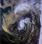
to its north, it reached its peak intensity as a large and powerful cyclone
. The storm lashed the East Coast of the United States
with high waves and coastal flooding, before turning to the southwest and weakening. Moving over warmer waters, the system transitioned into a subtropical cyclone
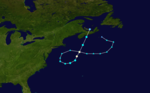
before becoming a tropical storm. It executed a loop off the Mid-Atlantic states
and turned toward the northeast. On November 1 the system evolved into a full-fledged hurricane with peak winds of 75 miles per hour (120 km/h), although the National Hurricane Center
left it unnamed to avoid confusion amid media interest in the predecessor extratropical storm. It later received the name "the Perfect Storm" after a conversation between Boston National Weather Service
forecaster Robert Case
and author Sebastian Junger
. The system was the fourth hurricane and final tropical cyclone in the 1991 Atlantic hurricane season
. The tropical system weakened, striking Nova Scotia as a tropical storm before dissipating.
Damage from the Perfect Storm totaled over $200 million (1991 USD) and the death toll was thirteen. Most of the damage occurred while the storm was extratropical, after waves up to 30 feet (9.1 m) struck the coastline from Canada to Florida and southeastward to Puerto Rico. In Massachusetts, where damage was heaviest, over 100 homes were destroyed or severely damaged. To the north, more than 100 homes were affected in Maine, including the vacation home of then-President
George H. W. Bush
. More than 38,000 people were left without power, and along the coast high waves inundated roads and buildings. In portions of New England, damage was worse than Hurricane Bob
had caused two months earlier.
Aside from tidal flooding along rivers, the storm's effects were primarily concentrated along the coast. A buoy
off the coast of Nova Scotia reported a wave height of 100.7 feet (30.7 m), the highest ever recorded in the province's offshore waters. In the middle of the storm, the Andrea Gail
sank, killing its crew of six and inspiring the book, and later movie
, The Perfect Storm. Off the shore of New York's Long Island
, an Air National Guard helicopter ran out of fuel and crashed; four members of its crew were rescued, and one was killed. Two people died after their boat sank off Staten Island
. High waves swept people to their deaths in Rhode Island and Puerto Rico, and another person was blown off a bridge to his death. The tropical cyclone that formed late in the storm's duration caused little impact, limited to power outages and slick roads; one person was killed in Newfoundland from a traffic accident related to the storm.
 The Perfect Storm originated from a cold front
that exited the east coast of the United States. On October 28, the front spawned an extratropical low to the east of Nova Scotia. Around that time, a ridge
extended from the Appalachian Mountains
northeastward to Greenland, with a strong high pressure center over eastern Canada. The blocking ridge forced the extratropical low to track toward the southeast and later to the west. Hurricane Grace was swept aloft by its cold front into the warm conveyor belt circulation of the deep cyclone on October 29. The cyclone significantly strengthened as a result of the temperature contrast between the cold air to the northwest and the warmth and humidity from the remnants of Hurricane Grace. The low pressure system continued deepening as it drifted toward the United States. It had an unusual retrograde motion for a nor'easter
, beginning a set of meteorological circumstances that occur only once every 50 to 100 years. Most nor'easters affect New England from the southwest.
 While situated about 390 miles (627.6 km) south of Halifax, Nova Scotia, the storm attained its peak intensity with winds of up to 70 mph (112.7 km/h). The nor'easter reached peak intensity at approximately 12:00 UTC on October 30 with its lowest pressure of 972 millibars. The interaction between the extratropical storm and the high pressure system to its north created a significant pressure gradient, which created large waves and strong winds. Between the southern New England coast and the storm's center, the gradient was 70 mbar (2.1 inHg). A buoy located 264 miles (424.9 km) south of Halifax reported a wave height of 100.7 feet (30.7 m) on October 30. This became the highest recorded wave height on the Scotian Shelf, which is the oceanic shelf
off the coast of Nova Scotia. East of Cape Cod, a NOAA buoy located at 41.1°N 66.6°W reported maximum sustained winds of 56 mph (90.1 km/h) with gusts to 75 mph (120.7 km/h), and a significant wave height
(average height of the highest waves) of 39 feet (11.9 m) around 15:00 UTC on October 30. Another buoy, located at 40.5°N 69.5°W, reported maximum sustained winds of 61 mph (98.2 km/h) with gusts to 72 mph (115.9 km/h) and a significant wave height of 31 feet (9.4 m) near 00:00 UTC on October 31.
Upon peaking in intensity, the nor'easter turned southward and gradually weakened; by November 1, its pressure had risen to 998 millibars (29.5 inHg). The low moved over warm waters of the Gulf Stream
, where bands
of convection
around the center began to organize. Around this time, the system attained subtropical characteristics. On November 1, while the storm was moving in a counter-clockwise loop, a tropical cyclone
had been identified at the center of the larger low. (Although these conditions are rare, Hurricane Karl
during 1980 also formed within a larger non-tropical weather system.)
By around 14:00 UTC on November 1, an eye feature
was forming, and the tropical cyclone reached its peak intensity with maximum sustained winds of 75 mph (120.7 km/h); these estimates, combined with reports from an Air Force Reserve Unit flight into the storm and confirmation that a warm-core
center was present, indicated that the system had become a Category 1 hurricane on the Saffir–Simpson Hurricane Scale. The hurricane accelerated toward the northeast and quickly weakened back into a tropical storm. It made landfall near Halifax, Nova Scotia, at 14:00 UTC on November 2 with sustained winds of 45 mph (72.4 km/h). While the storm was approaching the coast, weather radars depicted curved rainbands on the western side of the system. After crossing over Prince Edward Island
, it fully dissipated late on November 4.
 For several days, weather models
forecast the development of a significant storm off New England. However, the models were inadequate in forecasting coastal conditions, which in one instance prevented adequate warning. In addition, a post-storm assessment found an insufficient number of observation sites along the coast. On October 27, the Ocean Prediction Center
noted that a "dangerous storm" would form within 36 hours, with its wording emphasizing the unusual nature of the storm. The National Weather Service
likewise issued warnings for the potential storm, providing information to emergency service offices as well as the media. The public however was skeptical and did not recognize the threat. The timely warnings ultimately lowered the death toll; whereas the Perfect Storm caused 13 deaths, the blizzard of 1978
killed 99 people, and the 1938 New England hurricane killed 564 people.
From Massachusetts to Maine, thousands of people evacuated their homes and sought shelter. A state of emergency was declared for nine counties in Massachusetts, including Suffolk County
, as well as two in Maine. In North Carolina, the National Weather Service offices in Hatteras
and Raleigh
first issued a heavy surf advisory on October 27, more than eight hours before the first reports of high waves. That same day, a coastal flood watch and later a warning was issued, along with a gale warning. The Hatteras NWS office ultimately released 19 coastal flood statements, as well as media reports explaining the threat from the wind and waves, and a state of emergency was declared for Dare County, North Carolina
. The warnings and lead times in the region were described as "very good".
In Canada, the threat from the storm prompted the cancellation of ferry service from Bar Harbor, Maine
, to Yarmouth, Nova Scotia
, as well as from Nova Scotia to Prince Edward Island and between Nova Scotia and Newfoundland.
In its tropical cyclone report on the hurricane, the National Hurricane Center only referred to the system as "Unnamed Hurricane". The Natural Disaster Survey Report called the storm "The Halloween Nor’easter of 1991". The "perfect storm
" moniker was coined by author and journalist Sebastian Junger
after a conversation with NWS Boston Deputy Meteorologist Robert Case
in which Case described the convergence of weather conditions as being "perfect" for the formation of such a storm. Other National Weather Service offices were tasked with issuing warnings for this storm in lieu of the typical NHC advisories. The OPC posted warnings on the unnamed hurricane in its High Seas Forecasts. The National Weather Service State Forecast Office in Boston issued Offshore Marine Forecasts for the storm. Local NWS offices along the East coast covered the storm in their Coastal Waters Forecasts.
Beginning in 1950, the National Hurricane Center
named officially recognized tropical storms and hurricanes. The unnamed hurricane was reported to have met all the criteria for a tropical cyclone, but it was purposefully left unnamed. This was done to avoid confusion among the media and the public, who were focusing on the damage from the initial nor'easter, as the hurricane itself was not expected to pose a major threat to land. It was the eighth nameable storm of the 1991 Atlantic hurricane season
.
and southern New Jersey
. Across seven states, damage totaled over $200 million (1991 USD). Over a three-day period, the storm lashed the northeastern United States with high waves, causing damage to beachfront properties from North Carolina to Maine. The coastal flooding damaged or destroyed hundreds of homes and businesses and closed roads and airports. In addition, high winds left at least 38,000 people without power. The total without power was much less than for Hurricane Bob two months prior, and was fairly low due to little rainfall and the general lack of leaves on trees. Overall there were thirteen confirmed deaths, including six on board the Andrea Gail
, a swordfishing boat. The vessel departed Gloucester, Massachusetts
, for the waters off Nova Scotia. After encountering high seas in the middle of the storm, the vessel made its last radio contact late on October 28 about 180 miles (289.7 km) northeast of Sable Island
. The Andrea Gail sank while returning to Gloucester, its debris washing ashore over the subsequent weeks. The crew of six was presumed killed after a Coast Guard search was unable to find them. The storm and the boat's sinking became the center-piece for Sebastian Junger
's best-selling non-fiction book The Perfect Storm (1997), which was adapted to a major Hollywood film in 2000 as The Perfect Storm
starring George Clooney
.
 Despite the storm's severity, it was neither the costliest nor the strongest to affect the northeastern United States. It was weakening as it made its closest approach to land, and the highest tides occurred during the neap tide, which is the time when tide ranges are minimal. The worst of the storm effects stayed offshore. A buoy 650 miles (1,046.1 km) northeast of Nantucket, which was 60 miles (96.6 km) west of the Andrea Gail last known position, recorded a 73 ft (22.3 m) rise in wave height in 10 hours while the extratropical storm was still rapidly intensifying. Two buoys near the Massachusetts coast observed record wave heights, and one observed a record wind report. The United States Coast Guard
rescued at least 25 people at sea at the height of the storm, including 13 people from Long Island Sound
. A national guard helicopter crashed during the storm 90 miles (144.8 km) south of Montauk, New York
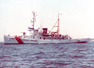
, after it ran out of fuel. After one helicopter attempted a rescue in the midst of the storm, an 18-person crew on the coast guard cutter Tamaroa
arrived and rescued four members of the crew of five after six hours in hypothermic waters. The last member was never found.
Following the storm's damage, President George Bush declared five counties in Maine, seven counties in Massachusetts, and Rockingham County, New Hampshire
to be disaster areas. The declaration allowed for the affected residents to apply for low-interest repair loans. New Jersey governor Jim Florio requested a declaration for portions of the coastline, but the request was denied because of the funding needs of other disasters, such as Hurricane Hugo
, Hurricane Bob, and the 1989 Loma Prieta earthquake. The American Red Cross
opened service centers in four locations in Massachusetts to assist the storm victims by providing food, clothing, medicine, and shelter. The agency deployed five vehicles carrying cleanup units and food, and also allocated $1.4 million to provide assistance to 3,000 families.
, the highest tide was 14.3 ft (4.4 m), which was only 1 ft (30.5 cm) lower than the record from the blizzard of 1978. High waves on top of the storm tide reached about 30 ft (9.1 m). The storm also produced heavy rainfall in southeastern Massachusetts, peaking at 5.5 inches (139.7 mm). Coastal floods closed several roads, forcing hundreds of people to evacuate. In addition to the high tides, the storm produced strong winds; Chatham
recorded a gust of 78 mph (125.5 km/h). Damage was worst from Cape Ann
in northeastern Massachusetts to Nantucket, with over 100 homes destroyed or severely damaged at Marshfield
, North Beach, and Brant Point
. There were two injuries in the state, although there were no fatalities. Across Massachusetts, damage totaled in the hundreds of millions of dollars.
Elsewhere in New England, waves up to 30 ft (9.1 m) reached as far north as Maine, along with tides that were 3 ft (0.9144 m) above normal. Significant flooding was reported in that state, along with high winds that left areas without power. A total of 49 houses were severely damaged, 2 were destroyed, and overall more than 100 were affected. In Kennebunkport
, the storm blew out windows and flooded the vacation home of then-President George H. W. Bush
. The home sustained significant damage to its first floor. In Portland
, tides were 3 ft (0.9144 m) above normal, among the ten highest tides since record-keeping began in 1914. Along the coast, damage was worse than that caused by Hurricane Bob two months prior. Across Maine, the storm left $7.9 million (1991 USD) in damage, mostly in York County
. More than half of the damage total was from property damage, with the remainder to transportation, seawalls, and public facilities. Although there were no deaths, there were two injuries in the state. In neighboring New Hampshire, coastal flooding affected several towns, destroying two homes. The storm destroyed three boats and damaged a lighthouse. High waves destroyed or swept away over 50,000 lobster traps, representing $2 million in losses (1991 USD). Damage was estimated at $5.6 million (1991 USD). Further west, high winds and coastal flooding lashed the Rhode Island and Connecticut coasts, killing a man in Narragansett, Rhode Island
. Winds reached 63 miles per hour (101.4 km/h) in Newport, Rhode Island
, causing power outages.
Off the coast of Atlantic Canada, the storm produced very high waves, flooding a ship near Sable Island
and stranding another ship. Along the coast, the waves wrecked three small boats near Tiverton, Nova Scotia
, as well as nine boats in Torbay, Newfoundland and Labrador
. In Nova Scotia, where the storm made landfall, precipitation reached 1.18 in (30 mm), and 20,000 people in Pictou County
were left without power. The storm also caused widespread power outages in Newfoundland from its high winds, which reached 68 mph (110 km/h) near St. Lawrence
. There were at least 35 traffic accidents, one fatal, in Grand Falls-Windsor due to slick roads. Prior to the storm's formation, there was a record 4.4 in (116 mm) of snowfall across Newfoundland. The storm caused no significant damage in Canada, other than these traffic accidents.
 In New York and northern New Jersey, the storm system left the most coastal damage since the 1944 Great Atlantic hurricane
. Numerous boats were damaged or destroyed, killing two people off Staten Island
. High winds swept a man off a bridge, killing him. High waves flooded the beach at Coney Island. In Sea Bright, New Jersey
, waves washed over a seawall, forcing 200 people to evacuate. Further inland, the Hudson
, Passaic
, and Hackensack
rivers experienced tidal flooding. Outside Massachusetts, damage was heaviest in southern New Jersey, where the cost was estimated at $75 million (1991 USD). Across the area, tide heights reached their highest since the 1944 hurricane, leaving severe coastal and back bay flooding and closing many roads. The storm also caused significant beach erosion, with 500,000 cubic yard
s (382,000 cubic meters) lost in Avalon
, as well as $10 million damage to the beach in Cape May
. The presence of a dune
system mitigated the erosion in some areas. There was also damage to the Atlantic City
Boardwalk. Following the storm, there was a moratorium
on clamming in the state's bays, due to contaminated waters. Along the Delmarva Peninsula
, there was widespread water damage to homes, including ten affected houses in Sandbridge Beach
, Virginia. Tides in Ocean City, Maryland
, reached a record height of 7.8 ft (2.4 m), while elsewhere the tides were similar to the Ash Wednesday Storm of 1962
.
, high waves were initially caused by Hurricane Grace and later its interaction with a high pressure system. This produced gale-force winds and 12 ft (3.7 m) waves in the town of Duck. Later, the extratropical predecessor to the unnamed hurricane produced additional high waves, causing oceanfront flooding from Cape Hatteras
through the northern portions of Currituck County
. Flooding was first reported on October 28, when the ocean covered a portion of North Carolina Highway 12 north of Rodanthe
; the route is the primary thoroughfare in the Outer Banks. Nags Head
, Kitty Hawk
, and Kill Devil Hills
had large portions covered with water for several blocks away from the beach. The resultant flooding damaged 525 houses and 28 businesses and destroyed two motels and a few homes. Damage was estimated at $6.7 million (1991 USD). Further south, the storm left 14 people injured in Florida. There was minor beach erosion and flooding, which damaged two houses and destroyed the pier at Lake Worth
. In some locations, beaches gained additional sand from the wave action. Two people went missing off Daytona Beach
after their boat lost power. High waves destroyed a portion of Florida State Road A1A
. Damage in the state was estimated at $3 million (1991 USD). High waves also affected Bermuda, the Bahamas, and the Dominican Republic. In Puerto Rico, waves of 15 ft (4.6 m) affected the island's north coast, which prompted 32 people to seek shelter. The waves swept a person off a large rock to their death.
Nor'easter
A nor'easter is a type of macro-scale storm along the East Coast of the United States and Atlantic Canada, so named because the storm travels to the northeast from the south and the winds come from the northeast, especially in the coastal areas of the Northeastern United States and Atlantic Canada...
that absorbed Hurricane Grace
Hurricane Grace (1991)
Hurricane Grace was a short-lived Category 2 hurricane that contributed to the formation of the powerful 1991 Perfect Storm. Forming on October 26, Grace initially had subtropical origins, meaning it was partially tropical and partially extratropical in nature. It became a tropical cyclone on...
and ultimately evolved into a small hurricane late in its life cycle. The initial area of low pressure
Low pressure area
A low-pressure area, or "low", is a region where the atmospheric pressure at sea level is below that of surrounding locations. Low-pressure systems form under areas of wind divergence which occur in upper levels of the troposphere. The formation process of a low-pressure area is known as...
developed off Atlantic Canada
Atlantic Canada
Atlantic Canada is the region of Canada comprising the four provinces located on the Atlantic coast, excluding Quebec: the three Maritime provinces – New Brunswick, Prince Edward Island, and Nova Scotia – and Newfoundland and Labrador...
on October 28. Forced southward by a ridge
Ridge (meteorology)
A ridge is an elongated region of relatively high atmospheric pressure, the opposite of a trough....
to its north, it reached its peak intensity as a large and powerful cyclone
Cyclone
In meteorology, a cyclone is an area of closed, circular fluid motion rotating in the same direction as the Earth. This is usually characterized by inward spiraling winds that rotate anticlockwise in the Northern Hemisphere and clockwise in the Southern Hemisphere of the Earth. Most large-scale...
. The storm lashed the East Coast of the United States
East Coast of the United States
The East Coast of the United States, also known as the Eastern Seaboard, refers to the easternmost coastal states in the United States, which touch the Atlantic Ocean and stretch up to Canada. The term includes the U.S...
with high waves and coastal flooding, before turning to the southwest and weakening. Moving over warmer waters, the system transitioned into a subtropical cyclone
Subtropical cyclone
A subtropical cyclone is a weather system that has some characteristics of a tropical and an extratropical cyclone. As early as the 1950s, meteorologists were unclear whether they should be characterized as tropical or extratropical cyclones. They were officially recognized by the National...
before becoming a tropical storm. It executed a loop off the Mid-Atlantic states
Mid-Atlantic States
The Mid-Atlantic states, also called middle Atlantic states or simply the mid Atlantic, form a region of the United States generally located between New England and the South...
and turned toward the northeast. On November 1 the system evolved into a full-fledged hurricane with peak winds of 75 miles per hour (120 km/h), although the National Hurricane Center
National Hurricane Center
The National Hurricane Center , located at Florida International University in Miami, Florida, is the division of the National Weather Service responsible for tracking and predicting weather systems within the tropics between the Prime Meridian and the 140th meridian west poleward to the 30th...
left it unnamed to avoid confusion amid media interest in the predecessor extratropical storm. It later received the name "the Perfect Storm" after a conversation between Boston National Weather Service
National Weather Service
The National Weather Service , once known as the Weather Bureau, is one of the six scientific agencies that make up the National Oceanic and Atmospheric Administration of the United States government...
forecaster Robert Case
Robert Case
Robert Allen "Bob" Case was a meteorologist who worked for the National Weather Service for 28 years. Over the course of his career, he worked in NWS various offices, developing a diverse background in various types of weather forecasting, including a lengthy stint as a hurricane forecaster...
and author Sebastian Junger
Sebastian Junger
Sebastian Junger is an American author, journalist and documentarian, most famous for the best-selling book The Perfect Storm: A True Story of Men Against the Sea, his award-winning chronicle of the war in Afghanistan in the 2010 movie Restrepo, and his 2010 book War.-Background:Junger was born...
. The system was the fourth hurricane and final tropical cyclone in the 1991 Atlantic hurricane season
1991 Atlantic hurricane season
The 1991 Atlantic hurricane season was the first season in over 24 years in which no hurricanes developed from tropical waves, which are the source for most North Atlantic tropical cyclones. The hurricane season officially began on June 1, and ended on November 30. It was the least...
. The tropical system weakened, striking Nova Scotia as a tropical storm before dissipating.
Damage from the Perfect Storm totaled over $200 million (1991 USD) and the death toll was thirteen. Most of the damage occurred while the storm was extratropical, after waves up to 30 feet (9.1 m) struck the coastline from Canada to Florida and southeastward to Puerto Rico. In Massachusetts, where damage was heaviest, over 100 homes were destroyed or severely damaged. To the north, more than 100 homes were affected in Maine, including the vacation home of then-President
President of the United States
The President of the United States of America is the head of state and head of government of the United States. The president leads the executive branch of the federal government and is the commander-in-chief of the United States Armed Forces....
George H. W. Bush
George H. W. Bush
George Herbert Walker Bush is an American politician who served as the 41st President of the United States . He had previously served as the 43rd Vice President of the United States , a congressman, an ambassador, and Director of Central Intelligence.Bush was born in Milton, Massachusetts, to...
. More than 38,000 people were left without power, and along the coast high waves inundated roads and buildings. In portions of New England, damage was worse than Hurricane Bob
Hurricane Bob
Hurricane Bob was one of the costliest hurricanes in New England history. The second named storm and first hurricane of the 1991 Atlantic hurricane season, Bob developed from an area of low pressure near The Bahamas on August 16. The depression steadily intensified, and became Tropical Storm Bob...
had caused two months earlier.
Aside from tidal flooding along rivers, the storm's effects were primarily concentrated along the coast. A buoy
Weather buoy
Weather buoys are instruments which collect weather and ocean data within the world's oceans, as well as aiding during emergency response to chemical spills, legal proceedings, and engineering design. Moored buoys have been in used since 1951, while drifting buoys have been used since 1979...
off the coast of Nova Scotia reported a wave height of 100.7 feet (30.7 m), the highest ever recorded in the province's offshore waters. In the middle of the storm, the Andrea Gail
Andrea Gail
The F/V Andrea Gail was a commercial fishing vessel that was lost at sea with all hands during the "Perfect Storm" of 1991. The vessel and her six-man crew had been fishing the North Atlantic Ocean out of Gloucester, Massachusetts. Her last reported position was northeast of Sable Island on...
sank, killing its crew of six and inspiring the book, and later movie
The Perfect Storm (film)
The Perfect Storm is a 2000 dramatic disaster film directed by Wolfgang Petersen. It is an adaptation of the 1997 non-fiction book of the same title by Sebastian Junger about the crew of the Andrea Gail that got caught in the Perfect Storm of 1991. The film stars George Clooney, Mark Wahlberg,...
, The Perfect Storm. Off the shore of New York's Long Island
Long Island
Long Island is an island located in the southeast part of the U.S. state of New York, just east of Manhattan. Stretching northeast into the Atlantic Ocean, Long Island contains four counties, two of which are boroughs of New York City , and two of which are mainly suburban...
, an Air National Guard helicopter ran out of fuel and crashed; four members of its crew were rescued, and one was killed. Two people died after their boat sank off Staten Island
Staten Island
Staten Island is a borough of New York City, New York, United States, located in the southwest part of the city. Staten Island is separated from New Jersey by the Arthur Kill and the Kill Van Kull, and from the rest of New York by New York Bay...
. High waves swept people to their deaths in Rhode Island and Puerto Rico, and another person was blown off a bridge to his death. The tropical cyclone that formed late in the storm's duration caused little impact, limited to power outages and slick roads; one person was killed in Newfoundland from a traffic accident related to the storm.
Meteorological history
Cold front
A cold front is defined as the leading edge of a cooler mass of air, replacing a warmer mass of air.-Development of cold front:The cooler and denser air wedges under the less-dense warmer air, lifting it...
that exited the east coast of the United States. On October 28, the front spawned an extratropical low to the east of Nova Scotia. Around that time, a ridge
Ridge (meteorology)
A ridge is an elongated region of relatively high atmospheric pressure, the opposite of a trough....
extended from the Appalachian Mountains
Appalachian Mountains
The Appalachian Mountains #Whether the stressed vowel is or ,#Whether the "ch" is pronounced as a fricative or an affricate , and#Whether the final vowel is the monophthong or the diphthong .), often called the Appalachians, are a system of mountains in eastern North America. The Appalachians...
northeastward to Greenland, with a strong high pressure center over eastern Canada. The blocking ridge forced the extratropical low to track toward the southeast and later to the west. Hurricane Grace was swept aloft by its cold front into the warm conveyor belt circulation of the deep cyclone on October 29. The cyclone significantly strengthened as a result of the temperature contrast between the cold air to the northwest and the warmth and humidity from the remnants of Hurricane Grace. The low pressure system continued deepening as it drifted toward the United States. It had an unusual retrograde motion for a nor'easter
Nor'easter
A nor'easter is a type of macro-scale storm along the East Coast of the United States and Atlantic Canada, so named because the storm travels to the northeast from the south and the winds come from the northeast, especially in the coastal areas of the Northeastern United States and Atlantic Canada...
, beginning a set of meteorological circumstances that occur only once every 50 to 100 years. Most nor'easters affect New England from the southwest.
Continental shelf
The continental shelf is the extended perimeter of each continent and associated coastal plain. Much of the shelf was exposed during glacial periods, but is now submerged under relatively shallow seas and gulfs, and was similarly submerged during other interglacial periods. The continental margin,...
off the coast of Nova Scotia. East of Cape Cod, a NOAA buoy located at 41.1°N 66.6°W reported maximum sustained winds of 56 mph (90.1 km/h) with gusts to 75 mph (120.7 km/h), and a significant wave height
Significant wave height
In physical oceanography, the significant wave height is defined traditionally as the mean wave height of the highest third of the waves , but now usually defined as four times the standard deviation of the surface elevation...
(average height of the highest waves) of 39 feet (11.9 m) around 15:00 UTC on October 30. Another buoy, located at 40.5°N 69.5°W, reported maximum sustained winds of 61 mph (98.2 km/h) with gusts to 72 mph (115.9 km/h) and a significant wave height of 31 feet (9.4 m) near 00:00 UTC on October 31.
Upon peaking in intensity, the nor'easter turned southward and gradually weakened; by November 1, its pressure had risen to 998 millibars (29.5 inHg). The low moved over warm waters of the Gulf Stream
Gulf Stream
The Gulf Stream, together with its northern extension towards Europe, the North Atlantic Drift, is a powerful, warm, and swift Atlantic ocean current that originates at the tip of Florida, and follows the eastern coastlines of the United States and Newfoundland before crossing the Atlantic Ocean...
, where bands
Rainband
A rainband is a cloud and precipitation structure associated with an area of rainfall which is significantly elongated. Rainbands can be stratiform or convective, and are generated by differences in temperature. When noted on weather radar imagery, this precipitation elongation is referred to as...
of convection
Atmospheric convection
Atmospheric convection is the result of a parcel-environment instability, or temperature difference, layer in the atmosphere. Different lapse rates within dry and moist air lead to instability. Mixing of air during the day which expands the height of the planetary boundary layer leads to...
around the center began to organize. Around this time, the system attained subtropical characteristics. On November 1, while the storm was moving in a counter-clockwise loop, a tropical cyclone
Tropical cyclone
A tropical cyclone is a storm system characterized by a large low-pressure center and numerous thunderstorms that produce strong winds and heavy rain. Tropical cyclones strengthen when water evaporated from the ocean is released as the saturated air rises, resulting in condensation of water vapor...
had been identified at the center of the larger low. (Although these conditions are rare, Hurricane Karl
Hurricane Karl (1980)
Hurricane Karl was a late-season and unusual tropical cyclone that formed during the 1980 Atlantic hurricane season. A minimal Category 1 hurricane on the Saffir–Simpson Hurricane Scale, Karl developed at the center of another, larger extratropical cyclone over the North Atlantic...
during 1980 also formed within a larger non-tropical weather system.)
By around 14:00 UTC on November 1, an eye feature
Eye (cyclone)
The eye is a region of mostly calm weather found at the center of strong tropical cyclones. The eye of a storm is a roughly circular area and typically 30–65 km in diameter. It is surrounded by the eyewall, a ring of towering thunderstorms where the second most severe weather of a cyclone...
was forming, and the tropical cyclone reached its peak intensity with maximum sustained winds of 75 mph (120.7 km/h); these estimates, combined with reports from an Air Force Reserve Unit flight into the storm and confirmation that a warm-core
Tropical cyclogenesis
Tropical cyclogenesis is the term that describes the development and strengthening of a tropical cyclone in the atmosphere. The mechanisms through which tropical cyclogenesis occurs are distinctly different from those through which mid-latitude cyclogenesis occurs...
center was present, indicated that the system had become a Category 1 hurricane on the Saffir–Simpson Hurricane Scale. The hurricane accelerated toward the northeast and quickly weakened back into a tropical storm. It made landfall near Halifax, Nova Scotia, at 14:00 UTC on November 2 with sustained winds of 45 mph (72.4 km/h). While the storm was approaching the coast, weather radars depicted curved rainbands on the western side of the system. After crossing over Prince Edward Island
Prince Edward Island
Prince Edward Island is a Canadian province consisting of an island of the same name, as well as other islands. The maritime province is the smallest in the nation in both land area and population...
, it fully dissipated late on November 4.
Preparations and naming
Numerical weather prediction
Numerical weather prediction uses mathematical models of the atmosphere and oceans to predict the weather based on current weather conditions. Though first attempted in the 1920s, it was not until the advent of computer simulation in the 1950s that numerical weather predictions produced realistic...
forecast the development of a significant storm off New England. However, the models were inadequate in forecasting coastal conditions, which in one instance prevented adequate warning. In addition, a post-storm assessment found an insufficient number of observation sites along the coast. On October 27, the Ocean Prediction Center
Ocean Prediction Center
The Ocean Prediction Center , established in 1995, is one of the National Centers for Environmental Prediction’s original six service centers. Until January 12, 2003, the name of the organization was the Marine Prediction Center. Its origins are traced back to the sinking of the RMS Titanic in...
noted that a "dangerous storm" would form within 36 hours, with its wording emphasizing the unusual nature of the storm. The National Weather Service
National Weather Service
The National Weather Service , once known as the Weather Bureau, is one of the six scientific agencies that make up the National Oceanic and Atmospheric Administration of the United States government...
likewise issued warnings for the potential storm, providing information to emergency service offices as well as the media. The public however was skeptical and did not recognize the threat. The timely warnings ultimately lowered the death toll; whereas the Perfect Storm caused 13 deaths, the blizzard of 1978
Northeastern United States Blizzard of 1978
The Northeastern United States blizzard of 1978 was a catastrophic and historic nor'easter that brought blizzard conditions to the New England region of the United States and the New York metropolitan area. The "Blizzard of '78" formed on February 5, 1978 and broke up on February 7, 1978...
killed 99 people, and the 1938 New England hurricane killed 564 people.
From Massachusetts to Maine, thousands of people evacuated their homes and sought shelter. A state of emergency was declared for nine counties in Massachusetts, including Suffolk County
Suffolk County, Massachusetts
Suffolk County has no land border with Plymouth County to its southeast, but the two counties share a water boundary in the middle of Massachusetts Bay.-National protected areas:*Boston African American National Historic Site...
, as well as two in Maine. In North Carolina, the National Weather Service offices in Hatteras
Hatteras, North Carolina
Hatteras is an unincorporated community in Dare County, North Carolina, United States, on the Outer Banks island of Hatteras. North Carolina Highway 12 passes through the community linking it to Frisco and Ocracoke . It is south of the famous Cape Hatteras and the Cape Hatteras Lighthouse in Buxton...
and Raleigh
Raleigh, North Carolina
Raleigh is the capital and the second largest city in the state of North Carolina as well as the seat of Wake County. Raleigh is known as the "City of Oaks" for its many oak trees. According to the U.S. Census Bureau, the city's 2010 population was 403,892, over an area of , making Raleigh...
first issued a heavy surf advisory on October 27, more than eight hours before the first reports of high waves. That same day, a coastal flood watch and later a warning was issued, along with a gale warning. The Hatteras NWS office ultimately released 19 coastal flood statements, as well as media reports explaining the threat from the wind and waves, and a state of emergency was declared for Dare County, North Carolina
Dare County, North Carolina
-National protected areas:* Alligator River National Wildlife Refuge * Cape Hatteras National Seashore * Fort Raleigh National Historic Site* Pea Island National Wildlife Refuge* Wright Brothers National Memorial-Demographics:...
. The warnings and lead times in the region were described as "very good".
In Canada, the threat from the storm prompted the cancellation of ferry service from Bar Harbor, Maine
Bar Harbor, Maine
Bar Harbor is a town on Mount Desert Island in Hancock County, Maine, United States. As of the 2010 census, its population is 5,235. Bar Harbor is a famous summer colony in the Down East region of Maine. It is home to the College of the Atlantic, Jackson Laboratory and Mount Desert Island...
, to Yarmouth, Nova Scotia
Yarmouth, Nova Scotia
Yarmouth is a town and fishing port located on the Gulf of Maine in rural southwestern Nova Scotia, Canada. It is the shire town of Yarmouth County. The town is located in the heart of the world's largest lobster fishing grounds and has Canada's highest lobster catch.- History :The townsite may...
, as well as from Nova Scotia to Prince Edward Island and between Nova Scotia and Newfoundland.
In its tropical cyclone report on the hurricane, the National Hurricane Center only referred to the system as "Unnamed Hurricane". The Natural Disaster Survey Report called the storm "The Halloween Nor’easter of 1991". The "perfect storm
Perfect storm
A "perfect storm" is an expression that describes an event where a rare combination of circumstances will aggravate a situation drastically. The term is also used to describe an actual phemonenon that happens to occur in such a confluence, resulting in an event of unusual magnitude.-Origin:First ...
" moniker was coined by author and journalist Sebastian Junger
Sebastian Junger
Sebastian Junger is an American author, journalist and documentarian, most famous for the best-selling book The Perfect Storm: A True Story of Men Against the Sea, his award-winning chronicle of the war in Afghanistan in the 2010 movie Restrepo, and his 2010 book War.-Background:Junger was born...
after a conversation with NWS Boston Deputy Meteorologist Robert Case
Robert Case
Robert Allen "Bob" Case was a meteorologist who worked for the National Weather Service for 28 years. Over the course of his career, he worked in NWS various offices, developing a diverse background in various types of weather forecasting, including a lengthy stint as a hurricane forecaster...
in which Case described the convergence of weather conditions as being "perfect" for the formation of such a storm. Other National Weather Service offices were tasked with issuing warnings for this storm in lieu of the typical NHC advisories. The OPC posted warnings on the unnamed hurricane in its High Seas Forecasts. The National Weather Service State Forecast Office in Boston issued Offshore Marine Forecasts for the storm. Local NWS offices along the East coast covered the storm in their Coastal Waters Forecasts.
Beginning in 1950, the National Hurricane Center
National Hurricane Center
The National Hurricane Center , located at Florida International University in Miami, Florida, is the division of the National Weather Service responsible for tracking and predicting weather systems within the tropics between the Prime Meridian and the 140th meridian west poleward to the 30th...
named officially recognized tropical storms and hurricanes. The unnamed hurricane was reported to have met all the criteria for a tropical cyclone, but it was purposefully left unnamed. This was done to avoid confusion among the media and the public, who were focusing on the damage from the initial nor'easter, as the hurricane itself was not expected to pose a major threat to land. It was the eighth nameable storm of the 1991 Atlantic hurricane season
1991 Atlantic hurricane season
The 1991 Atlantic hurricane season was the first season in over 24 years in which no hurricanes developed from tropical waves, which are the source for most North Atlantic tropical cyclones. The hurricane season officially began on June 1, and ended on November 30. It was the least...
.
Effects
The Halloween Storm of 1991 left significant damage along the east coast of the United States, primarily in MassachusettsMassachusetts
The Commonwealth of Massachusetts is a state in the New England region of the northeastern United States of America. It is bordered by Rhode Island and Connecticut to the south, New York to the west, and Vermont and New Hampshire to the north; at its east lies the Atlantic Ocean. As of the 2010...
and southern New Jersey
New Jersey
New Jersey is a state in the Northeastern and Middle Atlantic regions of the United States. , its population was 8,791,894. It is bordered on the north and east by the state of New York, on the southeast and south by the Atlantic Ocean, on the west by Pennsylvania and on the southwest by Delaware...
. Across seven states, damage totaled over $200 million (1991 USD). Over a three-day period, the storm lashed the northeastern United States with high waves, causing damage to beachfront properties from North Carolina to Maine. The coastal flooding damaged or destroyed hundreds of homes and businesses and closed roads and airports. In addition, high winds left at least 38,000 people without power. The total without power was much less than for Hurricane Bob two months prior, and was fairly low due to little rainfall and the general lack of leaves on trees. Overall there were thirteen confirmed deaths, including six on board the Andrea Gail
Andrea Gail
The F/V Andrea Gail was a commercial fishing vessel that was lost at sea with all hands during the "Perfect Storm" of 1991. The vessel and her six-man crew had been fishing the North Atlantic Ocean out of Gloucester, Massachusetts. Her last reported position was northeast of Sable Island on...
, a swordfishing boat. The vessel departed Gloucester, Massachusetts
Gloucester, Massachusetts
Gloucester is a city on Cape Ann in Essex County, Massachusetts, in the United States. It is part of Massachusetts' North Shore. The population was 28,789 at the 2010 U.S. Census...
, for the waters off Nova Scotia. After encountering high seas in the middle of the storm, the vessel made its last radio contact late on October 28 about 180 miles (289.7 km) northeast of Sable Island
Sable Island
Sable Island is a small Canadian island situated 300 km southeast of mainland Nova Scotia in the Atlantic Ocean. The island is a year-round home to approximately five people...
. The Andrea Gail sank while returning to Gloucester, its debris washing ashore over the subsequent weeks. The crew of six was presumed killed after a Coast Guard search was unable to find them. The storm and the boat's sinking became the center-piece for Sebastian Junger
Sebastian Junger
Sebastian Junger is an American author, journalist and documentarian, most famous for the best-selling book The Perfect Storm: A True Story of Men Against the Sea, his award-winning chronicle of the war in Afghanistan in the 2010 movie Restrepo, and his 2010 book War.-Background:Junger was born...
's best-selling non-fiction book The Perfect Storm (1997), which was adapted to a major Hollywood film in 2000 as The Perfect Storm
The Perfect Storm (film)
The Perfect Storm is a 2000 dramatic disaster film directed by Wolfgang Petersen. It is an adaptation of the 1997 non-fiction book of the same title by Sebastian Junger about the crew of the Andrea Gail that got caught in the Perfect Storm of 1991. The film stars George Clooney, Mark Wahlberg,...
starring George Clooney
George Clooney
George Timothy Clooney is an American actor, film director, producer, and screenwriter. For his work as an actor, he has received two Golden Globe Awards and an Academy Award...
.
United States Coast Guard
The United States Coast Guard is a branch of the United States Armed Forces and one of the seven U.S. uniformed services. The Coast Guard is a maritime, military, multi-mission service unique among the military branches for having a maritime law enforcement mission and a federal regulatory agency...
rescued at least 25 people at sea at the height of the storm, including 13 people from Long Island Sound
Long Island Sound
Long Island Sound is an estuary of the Atlantic Ocean, located in the United States between Connecticut to the north and Long Island, New York to the south. The mouth of the Connecticut River at Old Saybrook, Connecticut, empties into the sound. On its western end the sound is bounded by the Bronx...
. A national guard helicopter crashed during the storm 90 miles (144.8 km) south of Montauk, New York
Montauk, New York
Montauk [ˈmɒntɒk] is a census-designated place that roughly corresponds to the hamlet with the same name located in the town of East Hampton in Suffolk County, New York, United States on the South Shore of Long Island. As of the United States 2000 Census, the CDP population was 3,851 as of 2000...
, after it ran out of fuel. After one helicopter attempted a rescue in the midst of the storm, an 18-person crew on the coast guard cutter Tamaroa
USCGC Tamaroa (WMEC-166)
USCGC Tamaroa was a United States Coast Guard cutter, originally the United States Navy salvage tug USS Zuni . Following the USCG custom of naming cutters after Native American tribes, she is named after the Tamaroa tribe of the Illiniwek tribal group.She was one of 70 built in her class for the...
arrived and rescued four members of the crew of five after six hours in hypothermic waters. The last member was never found.
Following the storm's damage, President George Bush declared five counties in Maine, seven counties in Massachusetts, and Rockingham County, New Hampshire
Rockingham County, New Hampshire
-Demographics:As of the census of 2000, there were 277,359 people, 104,529 households, and 74,320 families residing in the county. The population density was 399 people per square mile . There were 113,023 housing units at an average density of 163 per square mile...
to be disaster areas. The declaration allowed for the affected residents to apply for low-interest repair loans. New Jersey governor Jim Florio requested a declaration for portions of the coastline, but the request was denied because of the funding needs of other disasters, such as Hurricane Hugo
Hurricane Hugo
Hurricane Hugo was a classical, destructive and rare Cape Verde-type hurricane which struck the Caribbean islands of Guadeloupe, Montserrat, St. Croix, Puerto Rico and the USA mainland in South Carolina as a Category 4 hurricane during September of the 1989 Atlantic hurricane season...
, Hurricane Bob, and the 1989 Loma Prieta earthquake. The American Red Cross
American Red Cross
The American Red Cross , also known as the American National Red Cross, is a volunteer-led, humanitarian organization that provides emergency assistance, disaster relief and education inside the United States. It is the designated U.S...
opened service centers in four locations in Massachusetts to assist the storm victims by providing food, clothing, medicine, and shelter. The agency deployed five vehicles carrying cleanup units and food, and also allocated $1.4 million to provide assistance to 3,000 families.
New England and Atlantic Canada
Along the Massachusetts coastline, the storm produced 25 ft (7.6 m) wave heights on top of a 4 ft (1.2 m) high tide. In BostonBoston
Boston is the capital of and largest city in Massachusetts, and is one of the oldest cities in the United States. The largest city in New England, Boston is regarded as the unofficial "Capital of New England" for its economic and cultural impact on the entire New England region. The city proper had...
, the highest tide was 14.3 ft (4.4 m), which was only 1 ft (30.5 cm) lower than the record from the blizzard of 1978. High waves on top of the storm tide reached about 30 ft (9.1 m). The storm also produced heavy rainfall in southeastern Massachusetts, peaking at 5.5 inches (139.7 mm). Coastal floods closed several roads, forcing hundreds of people to evacuate. In addition to the high tides, the storm produced strong winds; Chatham
Chatham, Massachusetts
Chatham is a town in Barnstable County, Massachusetts, United States, Barnstable County being coextensive with Cape Cod. The population was 6,625 at the 2000 census...
recorded a gust of 78 mph (125.5 km/h). Damage was worst from Cape Ann
Cape Ann
Cape Ann is a rocky cape in northeastern Massachusetts on the Atlantic Ocean. The cape is located approximately 30 miles northeast of Boston and forms the northern edge of Massachusetts Bay. Cape Ann includes the city of Gloucester, and the towns of Essex, Manchester-by-the-Sea, and...
in northeastern Massachusetts to Nantucket, with over 100 homes destroyed or severely damaged at Marshfield
Marshfield, Massachusetts
Marshfield is a town in Plymouth County, Massachusetts, United States, on Massachusetts's South Shore. The population was 25,132 at the 2010 census.See also: Green Harbor, Marshfield , Rexhame, Marshfield Hills, and Ocean Bluff and Brant Rock....
, North Beach, and Brant Point
Brant Point Light
Brant Point Light is a lighthouse located on Nantucket Island. It was established in 1746, automated in 1965, and is still in operation. The light station was added to the National Register of Historic Places on October 28, 1987. It has the distinction of being the tenth light on the point, in...
. There were two injuries in the state, although there were no fatalities. Across Massachusetts, damage totaled in the hundreds of millions of dollars.
Elsewhere in New England, waves up to 30 ft (9.1 m) reached as far north as Maine, along with tides that were 3 ft (0.9144 m) above normal. Significant flooding was reported in that state, along with high winds that left areas without power. A total of 49 houses were severely damaged, 2 were destroyed, and overall more than 100 were affected. In Kennebunkport
Kennebunkport, Maine
Kennebunkport is a town in York County, Maine, United States. The population was 3,720 at the 2000 census. It is part of the Portland–South Portland–Biddeford metropolitan statistical area....
, the storm blew out windows and flooded the vacation home of then-President George H. W. Bush
George H. W. Bush
George Herbert Walker Bush is an American politician who served as the 41st President of the United States . He had previously served as the 43rd Vice President of the United States , a congressman, an ambassador, and Director of Central Intelligence.Bush was born in Milton, Massachusetts, to...
. The home sustained significant damage to its first floor. In Portland
Portland, Maine
Portland is the largest city in Maine and is the county seat of Cumberland County. The 2010 city population was 66,194, growing 3 percent since the census of 2000...
, tides were 3 ft (0.9144 m) above normal, among the ten highest tides since record-keeping began in 1914. Along the coast, damage was worse than that caused by Hurricane Bob two months prior. Across Maine, the storm left $7.9 million (1991 USD) in damage, mostly in York County
York County, Maine
York County is a county located in the U.S. state of Maine. In 2010, the population was 197,131. Its county seat is Alfred.Founded in 1636, it is the oldest county in Maine and one of the oldest in the United States....
. More than half of the damage total was from property damage, with the remainder to transportation, seawalls, and public facilities. Although there were no deaths, there were two injuries in the state. In neighboring New Hampshire, coastal flooding affected several towns, destroying two homes. The storm destroyed three boats and damaged a lighthouse. High waves destroyed or swept away over 50,000 lobster traps, representing $2 million in losses (1991 USD). Damage was estimated at $5.6 million (1991 USD). Further west, high winds and coastal flooding lashed the Rhode Island and Connecticut coasts, killing a man in Narragansett, Rhode Island
Narragansett, Rhode Island
Narragansett is a town in Washington County, Rhode Island, United States. The population was 15,868 at the 2010 census, but there is a greater population in the summer. The nickname for the town is "Gansett". The town of Narragansett occupies a narrow strip of land running along the eastern bank...
. Winds reached 63 miles per hour (101.4 km/h) in Newport, Rhode Island
Newport, Rhode Island
Newport is a city on Aquidneck Island in Newport County, Rhode Island, United States, about south of Providence. Known as a New England summer resort and for the famous Newport Mansions, it is the home of Salve Regina University and Naval Station Newport which houses the United States Naval War...
, causing power outages.
Off the coast of Atlantic Canada, the storm produced very high waves, flooding a ship near Sable Island
Sable Island
Sable Island is a small Canadian island situated 300 km southeast of mainland Nova Scotia in the Atlantic Ocean. The island is a year-round home to approximately five people...
and stranding another ship. Along the coast, the waves wrecked three small boats near Tiverton, Nova Scotia
Tiverton, Nova Scotia
Tiverton is a small village located on the northeast tip of Long Island, Nova Scotia. Tiverton has a population of about 300 people .The main industry is lobster fishing, while a second, and growing industry, is tourism. The Bay of Fundy is known for whale watching, and Tiverton and the surrounding...
, as well as nine boats in Torbay, Newfoundland and Labrador
Torbay, Newfoundland and Labrador
Torbay is a town located on the eastern side of the Avalon Peninsula in Newfoundland and Labrador, Canada.The town is located north of the capital city of St. John's and is part of the St. John's Metropolitan Area. Due to the Torbay's close proximity with St. John's, the town's population is...
. In Nova Scotia, where the storm made landfall, precipitation reached 1.18 in (30 mm), and 20,000 people in Pictou County
Pictou County, Nova Scotia
Pictou County is a county in the Canadian province of Nova Scotia. It was established in 1835, and was formerly a part of Halifax County from 1759 to 1835. It had a population of 46,513 people in 2006, which represents a decline of 6.3 percent from 1991. It is the sixth most populous county in Nova...
were left without power. The storm also caused widespread power outages in Newfoundland from its high winds, which reached 68 mph (110 km/h) near St. Lawrence
St. Lawrence, Newfoundland and Labrador
St. Lawrence is a Canadian town located on the Burin Peninsula of Newfoundland and Labrador. As of 2006, the population of St. Lawrence was 1,349.-History:...
. There were at least 35 traffic accidents, one fatal, in Grand Falls-Windsor due to slick roads. Prior to the storm's formation, there was a record 4.4 in (116 mm) of snowfall across Newfoundland. The storm caused no significant damage in Canada, other than these traffic accidents.
Mid-Atlantic states
1944 Great Atlantic Hurricane
The Great Atlantic Hurricane in 1944 was an intense Atlantic hurricane sometimes compared to the New England Hurricane of 1938.-Meteorological history:...
. Numerous boats were damaged or destroyed, killing two people off Staten Island
Staten Island
Staten Island is a borough of New York City, New York, United States, located in the southwest part of the city. Staten Island is separated from New Jersey by the Arthur Kill and the Kill Van Kull, and from the rest of New York by New York Bay...
. High winds swept a man off a bridge, killing him. High waves flooded the beach at Coney Island. In Sea Bright, New Jersey
Sea Bright, New Jersey
Sea Bright is a borough in Monmouth County, New Jersey, United States. As of the 2010 United States Census, the borough population was 1,412.Sea Bright was formed as a borough by an act of the New Jersey Legislature on March 21, 1889, from portions of Ocean Township, based on the results of a...
, waves washed over a seawall, forcing 200 people to evacuate. Further inland, the Hudson
Hudson River
The Hudson is a river that flows from north to south through eastern New York. The highest official source is at Lake Tear of the Clouds, on the slopes of Mount Marcy in the Adirondack Mountains. The river itself officially begins in Henderson Lake in Newcomb, New York...
, Passaic
Passaic River
The Passaic River is a mature surface river, approximately 80 mi long, in northern New Jersey in the United States. The river in its upper course flows in a highly circuitous route, meandering through the swamp lowlands between the ridge hills of rural and suburban northern New Jersey,...
, and Hackensack
Hackensack River
The Hackensack River is a river, approximately 45 miles long, in the U.S. states of New York and New Jersey, emptying into Newark Bay, a back chamber of New York Harbor. The watershed of the river includes part of the suburban area outside New York City just west of the lower Hudson River,...
rivers experienced tidal flooding. Outside Massachusetts, damage was heaviest in southern New Jersey, where the cost was estimated at $75 million (1991 USD). Across the area, tide heights reached their highest since the 1944 hurricane, leaving severe coastal and back bay flooding and closing many roads. The storm also caused significant beach erosion, with 500,000 cubic yard
Cubic yard
A cubic yard is an Imperial / U.S. customary unit of volume, used in the United States, Canada, and the UK. It is defined as the volume of a cube with sides of 1 yard in length.-Symbols:...
s (382,000 cubic meters) lost in Avalon
Avalon, New Jersey
As of April 2009, the average home sales price in Avalon was $1,567,662 .As of the census of 2000, there were 2,143 people, 1,045 households, and 668 families residing in the borough. The population density was 508.4 people per square mile...
, as well as $10 million damage to the beach in Cape May
Cape May, New Jersey
Cape May is a city at the southern tip of Cape May Peninsula in Cape May County, New Jersey, where the Delaware Bay meets the Atlantic Ocean and is one of the country's oldest vacation resort destinations. It is part of the Ocean City Metropolitan Statistical Area. As of the 2010 United States...
. The presence of a dune
Dune
In physical geography, a dune is a hill of sand built by wind. Dunes occur in different forms and sizes, formed by interaction with the wind. Most kinds of dunes are longer on the windward side where the sand is pushed up the dune and have a shorter "slip face" in the lee of the wind...
system mitigated the erosion in some areas. There was also damage to the Atlantic City
Atlantic City, New Jersey
Atlantic City is a city in Atlantic County, New Jersey, United States, and a nationally renowned resort city for gambling, shopping and fine dining. The city also served as the inspiration for the American version of the board game Monopoly. Atlantic City is located on Absecon Island on the coast...
Boardwalk. Following the storm, there was a moratorium
Moratorium (law)
A moratorium is a delay or suspension of an activity or a law. In a legal context, it may refer to the temporary suspension of a law to allow a legal challenge to be carried out....
on clamming in the state's bays, due to contaminated waters. Along the Delmarva Peninsula
Delmarva Peninsula
The Delmarva Peninsula is a large peninsula on the East Coast of the United States, occupied by most of Delaware and portions of Maryland and Virginia...
, there was widespread water damage to homes, including ten affected houses in Sandbridge Beach
Sandbridge Beach
Sandbridge Beach is in the southern part of the city of Virginia Beach, Virginia, USA. Its location is like that of the Outer Banks of North Carolina, with the Back Bay of the Currituck Sound to the west and the Atlantic Ocean to the east. Located at the very end of the beach is the city park,...
, Virginia. Tides in Ocean City, Maryland
Ocean City, Maryland
Ocean City, sometimes known as OC, or OCMD, is an Atlantic Ocean resort town in Worcester County, Maryland, United States. Ocean City is widely known in the Mid-Atlantic region of the United States and is a frequent destination for vacationers in that area...
, reached a record height of 7.8 ft (2.4 m), while elsewhere the tides were similar to the Ash Wednesday Storm of 1962
Ash Wednesday Storm of 1962
The Ash Wednesday Storm of 1962 occurred on March 6–8, 1962 along the mid-Atlantic coast of the United States. It was considered by the U.S. Geological Survey to be one of the most destructive storms ever to affect the mid-Atlantic states...
.
Further south
In North Carolina along the Outer BanksOuter Banks
The Outer Banks is a 200-mile long string of narrow barrier islands off the coast of North Carolina, beginning in the southeastern corner of Virginia Beach on the east coast of the United States....
, high waves were initially caused by Hurricane Grace and later its interaction with a high pressure system. This produced gale-force winds and 12 ft (3.7 m) waves in the town of Duck. Later, the extratropical predecessor to the unnamed hurricane produced additional high waves, causing oceanfront flooding from Cape Hatteras
Cape Hatteras
Cape Hatteras is a cape on the coast of North Carolina. It is the point that protrudes the farthest to the southeast along the northeast-to-southwest line of the Atlantic coast of North America...
through the northern portions of Currituck County
Currituck County, North Carolina
-National protected areas:*Currituck National Wildlife Refuge*Mackay Island National Wildlife Refuge -Demographics:As of the census of 2010, there were 23,547 people, 6,902 households, and 5,204 families residing in the county. The population density was 70 people per square mile . There were...
. Flooding was first reported on October 28, when the ocean covered a portion of North Carolina Highway 12 north of Rodanthe
Rodanthe, North Carolina
Rodanthe is an unincorporated community located in Dare County, North Carolina, on Hatteras Island, part of North Carolina's Outer Banks. Rodanthe, along with Waves and Salvo, are part of the settlement of Chicamacomico...
; the route is the primary thoroughfare in the Outer Banks. Nags Head
Nags Head, North Carolina
Nags Head is a town in Dare County, North Carolina, United States. The population was 2,700 at the 2000 census.-History:Early maps of the area show Nags Head as a promontory of land characterized by high sand dunes visible from miles at sea...
, Kitty Hawk
Kitty Hawk, North Carolina
Kitty Hawk is a town in Dare County, North Carolina, United States. The population was 3,000 at the 2000 census. It was established in the early 18th century as Chickahawk....
, and Kill Devil Hills
Kill Devil Hills, North Carolina
Kill Devil Hills is a town in Dare County, North Carolina, USA. The population was 5,897 at the 2000 census.Nearby Kitty Hawk is frequently cited as the location of the Wright brothers' first controlled, powered airplane flights on December 17, 1903...
had large portions covered with water for several blocks away from the beach. The resultant flooding damaged 525 houses and 28 businesses and destroyed two motels and a few homes. Damage was estimated at $6.7 million (1991 USD). Further south, the storm left 14 people injured in Florida. There was minor beach erosion and flooding, which damaged two houses and destroyed the pier at Lake Worth
Lake Worth, Florida
Lake Worth is a city in Palm Beach County, Florida, which takes its name from the body of water along its eastern border, originally called "Lake Worth", and now generally known as the Lake Worth Lagoon. The lake itself was named for General William J. Worth, who led U.S. forces during the last...
. In some locations, beaches gained additional sand from the wave action. Two people went missing off Daytona Beach
Daytona Beach, Florida
Daytona Beach is a city in Volusia County, Florida, USA. According to 2008 U.S. Census Bureau estimates, the city has a population of 64,211. Daytona Beach is a principal city of the Deltona – Daytona Beach – Ormond Beach, Florida Metropolitan Statistical Area, which the census bureau estimated had...
after their boat lost power. High waves destroyed a portion of Florida State Road A1A
Florida State Road A1A
State Road A1A is a Florida State Road that runs mostly along the Atlantic Ocean, with sections from Key West at the southern tip of Florida, to Callahan, just south of Georgia. It is the main road through most oceanfront towns. SR A1A is designated the A1A Scenic and Historic Coastal Highway, a...
. Damage in the state was estimated at $3 million (1991 USD). High waves also affected Bermuda, the Bahamas, and the Dominican Republic. In Puerto Rico, waves of 15 ft (4.6 m) affected the island's north coast, which prompted 32 people to seek shelter. The waves swept a person off a large rock to their death.
See also
- 1991 Halloween blizzard
- North Atlantic tropical cyclone
- List of New England hurricanes
- List of Canada hurricanes