
1922 Atlantic hurricane season
Encyclopedia
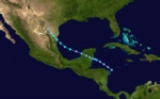
The 1922 Atlantic hurricane season ran through the summer and the first half of fall in 1922. The season was a quiet one, with only five tropical cyclones forming during the course of the season. The first was a tropical storm that passed over the Yucatán Peninsula
and later made another landfall in rural northeast Mexico
. The second was a hurricane, the strongest one of the season. It formed near Cape Verde
and curved out into the Atlantic. It grazed the Leeward Islands
and battered Bermuda
, passing just offshore as a Category 3. The hurricane became extratropical soon after it passed Bermuda. The third was a tropical storm that passed over Cuba
and made landfall near Pensacola, Florida
. The last storm of the season was a Category 2
hurricane that made landfall near Cancún, Mexico
. The hurricane weakened in the Bay of Campeche
and dissipated just offshore. A fifth storm was found in reanalysis in 2009.
. Once it emerged into the Gulf of Mexico
, it began to grow in intensity. The Monthly Weather Review
says the storm resembled a developing hurricane. According to the Best Track data, however, winds never exceeded 50 mi/h. Landfall in mainland Mexico stopped the intensification. It came ashore in a sparsely populated area near the village of La Pesca, about 150 miles (241.4 km) south of the mouth of the Rio Grande
. The storm brought very heavy rain to the Rio Grande Valley that caused significant flooding, but no fatalities were reported.
and moved northwestward steadily strengthening. It grazed the Leeward Islands
as a Category 2 hurricane and began to recurve shortly thereafter. During this recurvature, it strengthened into a Category 3 storm, eventually attaining winds of 120 mi/h. It would maintain Category 3 intensity for the next four days until it became extratropical on September 23. The storm passed almost directly over Bermuda
early on September 21, buffeting the island with 115 mi/h winds and an eight-foot storm surge
. As the center of this hurricane passed Bermuda
to the southeast, a lull occurred on the island for an hour around 9 am on September 21. The lowest pressure measured was 968 mbar (28.57 inHg). Significant damage occurred there, as winds peaked at 120 mi/h. It was Bermuda's highest tide since the hurricane of 1899. The hurricane remains the strongest Atlantic tropical cyclone above 30.4°N
, since Hurricane Dog
of 1950
weakened to below 150 mph (240 km/h) as it reached that latitude.
on September 18. It moved towards the northeast and became a minimal hurricane well off the coast of North Carolina
on September 21. It weakened as it moved into the open Atlantic.
This hurricane was not discovered until reanalysis in 2009.
was detected by the S.S. Chalmette in the western Caribbean Sea
, and the system is believed to have organized to a minimal tropical storm 260 miles (420 km) southwest of Kingston, Jamaica
late on October 13. The cyclone slowly moved northwest, and it gradually intensified on October 15. On the evening of October 16, the tropical storm rapidly intensified, and it strengthened to the equivalent of a category 2 hurricane on October 17. Later, it attained peak sustained winds
of 110 mph (175 km/h). Early on October 18, a ship reported a minimum pressure of 984 mbar (29.06 inHg) near the center, which was the lowest pressure measured during the life span of the storm. Subsequently, the hurricane weakened, and it made landfall
10 miles (16 km) south of Cancún with winds of 80 mph (130 km/h). It crossed the peninsula and moved south along the coast, weakening to a minimal tropical storm and striking the Tabasco
area. The storm caused significant property damage and shipping losses. Several fishing vessels sank and some ocean liners (including the now-infamous Morro Castle
) were stranded outside Vera Cruz harbor because violent seas made it too dangerous to enter. There were a few fatalities in the Yucatan, where damage to buildings and crops was severe.
. The storm dissipated quickly inland. It may have been a subtropical storm due to some hybrid characteristics.
Yucatán Peninsula
The Yucatán Peninsula, in southeastern Mexico, separates the Caribbean Sea from the Gulf of Mexico, with the northern coastline on the Yucatán Channel...
and later made another landfall in rural northeast Mexico
Mexico
The United Mexican States , commonly known as Mexico , is a federal constitutional republic in North America. It is bordered on the north by the United States; on the south and west by the Pacific Ocean; on the southeast by Guatemala, Belize, and the Caribbean Sea; and on the east by the Gulf of...
. The second was a hurricane, the strongest one of the season. It formed near Cape Verde
Cape Verde
The Republic of Cape Verde is an island country, spanning an archipelago of 10 islands located in the central Atlantic Ocean, 570 kilometres off the coast of Western Africa...
and curved out into the Atlantic. It grazed the Leeward Islands
Leeward Islands
The Leeward Islands are a group of islands in the West Indies. They are the northern islands of the Lesser Antilles chain. As a group they start east of Puerto Rico and reach southward to Dominica. They are situated where the northeastern Caribbean Sea meets the western Atlantic Ocean...
and battered Bermuda
Bermuda
Bermuda is a British overseas territory in the North Atlantic Ocean. Located off the east coast of the United States, its nearest landmass is Cape Hatteras, North Carolina, about to the west-northwest. It is about south of Halifax, Nova Scotia, Canada, and northeast of Miami, Florida...
, passing just offshore as a Category 3. The hurricane became extratropical soon after it passed Bermuda. The third was a tropical storm that passed over Cuba
Cuba
The Republic of Cuba is an island nation in the Caribbean. The nation of Cuba consists of the main island of Cuba, the Isla de la Juventud, and several archipelagos. Havana is the largest city in Cuba and the country's capital. Santiago de Cuba is the second largest city...
and made landfall near Pensacola, Florida
Pensacola, Florida
Pensacola is the westernmost city in the Florida Panhandle and the county seat of Escambia County, Florida, United States of America. As of the 2000 census, the city had a total population of 56,255 and as of 2009, the estimated population was 53,752...
. The last storm of the season was a Category 2
Saffir-Simpson Hurricane Scale
The Saffir–Simpson Hurricane Scale , or the Saffir–Simpson Hurricane Wind Scale , classifies hurricanes — Western Hemisphere tropical cyclones that exceed the intensities of tropical depressions and tropical storms — into five categories distinguished by the intensities of their sustained winds...
hurricane that made landfall near Cancún, Mexico
Cancún
Cancún is a city of international tourism development certified by the UNWTO . Located on the northeast coast of Quintana Roo in southern Mexico, more than 1,700 km from Mexico City, the Project began operations in 1974 as Integrally Planned Center, a pioneer of FONATUR Cancún is a city of...
. The hurricane weakened in the Bay of Campeche
Bay of Campeche
The Bay of Campeche is the southern bight of the Gulf of Mexico. It is surrounded on three sides by the Mexican states of Campeche, Tabasco and Veracruz. It was named by Francisco Hernández de Córdoba and Antonio de Alaminos during their expedition in 1517...
and dissipated just offshore. A fifth storm was found in reanalysis in 2009.
Tropical Storm One
The first storm of the season formed off Cabo Gracias, Nicaragua on June 12 and moved generally northwestward. The storm strengthened very little before hitting the central Yucatan PeninsulaYucatán Peninsula
The Yucatán Peninsula, in southeastern Mexico, separates the Caribbean Sea from the Gulf of Mexico, with the northern coastline on the Yucatán Channel...
. Once it emerged into the Gulf of Mexico
Gulf of Mexico
The Gulf of Mexico is a partially landlocked ocean basin largely surrounded by the North American continent and the island of Cuba. It is bounded on the northeast, north and northwest by the Gulf Coast of the United States, on the southwest and south by Mexico, and on the southeast by Cuba. In...
, it began to grow in intensity. The Monthly Weather Review
Monthly Weather Review
The Monthly Weather Review is a scientific journal published by the American Meteorological Society.Topics covered by the journal include research related to analysis and prediction of observed and modeled circulations of the atmosphere, including technique development, data assimilation, model...
says the storm resembled a developing hurricane. According to the Best Track data, however, winds never exceeded 50 mi/h. Landfall in mainland Mexico stopped the intensification. It came ashore in a sparsely populated area near the village of La Pesca, about 150 miles (241.4 km) south of the mouth of the Rio Grande
Rio Grande
The Rio Grande is a river that flows from southwestern Colorado in the United States to the Gulf of Mexico. Along the way it forms part of the Mexico – United States border. Its length varies as its course changes...
. The storm brought very heavy rain to the Rio Grande Valley that caused significant flooding, but no fatalities were reported.
Hurricane Two
By far the most powerful storm of the season, this hurricane formed well east of the Windward IslandsWindward Islands
The Windward Islands are the southern islands of the Lesser Antilles, within the West Indies.-Name and geography:The Windward Islands are called such because they were more windward to sailing ships arriving in the New World than the Leeward Islands, given that the prevailing trade winds in the...
and moved northwestward steadily strengthening. It grazed the Leeward Islands
Leeward Islands
The Leeward Islands are a group of islands in the West Indies. They are the northern islands of the Lesser Antilles chain. As a group they start east of Puerto Rico and reach southward to Dominica. They are situated where the northeastern Caribbean Sea meets the western Atlantic Ocean...
as a Category 2 hurricane and began to recurve shortly thereafter. During this recurvature, it strengthened into a Category 3 storm, eventually attaining winds of 120 mi/h. It would maintain Category 3 intensity for the next four days until it became extratropical on September 23. The storm passed almost directly over Bermuda
Bermuda
Bermuda is a British overseas territory in the North Atlantic Ocean. Located off the east coast of the United States, its nearest landmass is Cape Hatteras, North Carolina, about to the west-northwest. It is about south of Halifax, Nova Scotia, Canada, and northeast of Miami, Florida...
early on September 21, buffeting the island with 115 mi/h winds and an eight-foot storm surge
Storm surge
A storm surge is an offshore rise of water associated with a low pressure weather system, typically tropical cyclones and strong extratropical cyclones. Storm surges are caused primarily by high winds pushing on the ocean's surface. The wind causes the water to pile up higher than the ordinary sea...
. As the center of this hurricane passed Bermuda
Bermuda
Bermuda is a British overseas territory in the North Atlantic Ocean. Located off the east coast of the United States, its nearest landmass is Cape Hatteras, North Carolina, about to the west-northwest. It is about south of Halifax, Nova Scotia, Canada, and northeast of Miami, Florida...
to the southeast, a lull occurred on the island for an hour around 9 am on September 21. The lowest pressure measured was 968 mbar (28.57 inHg). Significant damage occurred there, as winds peaked at 120 mi/h. It was Bermuda's highest tide since the hurricane of 1899. The hurricane remains the strongest Atlantic tropical cyclone above 30.4°N
Latitude
In geography, the latitude of a location on the Earth is the angular distance of that location south or north of the Equator. The latitude is an angle, and is usually measured in degrees . The equator has a latitude of 0°, the North pole has a latitude of 90° north , and the South pole has a...
, since Hurricane Dog
Hurricane Dog (1950)
Hurricane Dog was the most intense hurricane in the 1950 Atlantic hurricane season. The fourth named storm of the season, Dog developed on August 30 to the east of Antigua; after passing through the northern Lesser Antilles, it turned to the north and intensified into a Category 5 hurricane...
of 1950
1950 Atlantic hurricane season
The 1950 Atlantic hurricane season was the first year in which tropical cyclones were given official names in the Atlantic basin. Names were taken from the Joint Army/Navy Phonetic Alphabet, with the first named storm being designated "Able", the second "Baker", and so on. It was an active season...
weakened to below 150 mph (240 km/h) as it reached that latitude.
Hurricane Three
A tropical storm formed off the east coast of FloridaFlorida
Florida is a state in the southeastern United States, located on the nation's Atlantic and Gulf coasts. It is bordered to the west by the Gulf of Mexico, to the north by Alabama and Georgia and to the east by the Atlantic Ocean. With a population of 18,801,310 as measured by the 2010 census, it...
on September 18. It moved towards the northeast and became a minimal hurricane well off the coast of North Carolina
North Carolina
North Carolina is a state located in the southeastern United States. The state borders South Carolina and Georgia to the south, Tennessee to the west and Virginia to the north. North Carolina contains 100 counties. Its capital is Raleigh, and its largest city is Charlotte...
on September 21. It weakened as it moved into the open Atlantic.
This hurricane was not discovered until reanalysis in 2009.
Hurricane Four
Early on October 12, a low pressure areaLow pressure area
A low-pressure area, or "low", is a region where the atmospheric pressure at sea level is below that of surrounding locations. Low-pressure systems form under areas of wind divergence which occur in upper levels of the troposphere. The formation process of a low-pressure area is known as...
was detected by the S.S. Chalmette in the western Caribbean Sea
Caribbean Sea
The Caribbean Sea is a sea of the Atlantic Ocean located in the tropics of the Western hemisphere. It is bounded by Mexico and Central America to the west and southwest, to the north by the Greater Antilles, and to the east by the Lesser Antilles....
, and the system is believed to have organized to a minimal tropical storm 260 miles (420 km) southwest of Kingston, Jamaica
Kingston, Jamaica
Kingston is the capital and largest city of Jamaica, located on the southeastern coast of the island. It faces a natural harbour protected by the Palisadoes, a long sand spit which connects the town of Port Royal and the Norman Manley International Airport to the rest of the island...
late on October 13. The cyclone slowly moved northwest, and it gradually intensified on October 15. On the evening of October 16, the tropical storm rapidly intensified, and it strengthened to the equivalent of a category 2 hurricane on October 17. Later, it attained peak sustained winds
Maximum sustained wind
The maximum sustained winds associated with a tropical cyclone are a common indicator of the intensity of the storm. Within a mature tropical cyclone, they are found within the eyewall at a distance defined as the radius of maximum wind, or RMW. Unlike gusts, the value of these winds are...
of 110 mph (175 km/h). Early on October 18, a ship reported a minimum pressure of 984 mbar (29.06 inHg) near the center, which was the lowest pressure measured during the life span of the storm. Subsequently, the hurricane weakened, and it made landfall
Landfall (meteorology)
Landfall is the event of a tropical cyclone or a waterspout coming onto land after being over water. When a waterspout makes landfall it is reclassified as a tornado, which can then cause damage inland...
10 miles (16 km) south of Cancún with winds of 80 mph (130 km/h). It crossed the peninsula and moved south along the coast, weakening to a minimal tropical storm and striking the Tabasco
Tabasco
Tabasco officially Estado Libre y Soberano de Tabasco is one of the 31 states which, with the Federal District, comprise the 32 Federal Entities of Mexico. It is divided in 17 municipalities and its capital city is Villahermosa....
area. The storm caused significant property damage and shipping losses. Several fishing vessels sank and some ocean liners (including the now-infamous Morro Castle
SS Morro Castle
The SS Morro Castle was a luxury cruise ship of the 1930s that was built for the Ward Line for runs between New York City and Havana, Cuba...
) were stranded outside Vera Cruz harbor because violent seas made it too dangerous to enter. There were a few fatalities in the Yucatan, where damage to buildings and crops was severe.
Tropical Storm Five
Storm Five formed of the northern coast of Honduras on October 12 and turned northwestward. The storm strengthened very little during its lifetime, striking western Cuba with only 45 mi/h sustained winds. It reached its peak intensity of 50 mi/h in the Gulf of Mexico. It held this intensity for two days, weakening just before landfall near Orange Beach, AlabamaOrange Beach, Alabama
Orange Beach is a city in Baldwin County, Alabama, United States. At the 2000 census the population was 3,784. It is part of the Daphne–Fairhope–Foley Micropolitan Statistical Area.-Geography:...
. The storm dissipated quickly inland. It may have been a subtropical storm due to some hybrid characteristics.
See also
- List of tropical cyclones
- List of Atlantic hurricane seasons