

Swarth Fell
Encyclopedia
Swarth Fell
is an approximately 1 mile (1.5 km) stretch of high ground (consisting mainly of limestone
capped with millstone grit
) situated to the south of Wild Boar Fell
, of which it is a continuation.
It is mostly within Mallerstang
, Cumbria
, but the boundary between Cumbria and North Yorkshire
runs along its length, just to the west of the highest points.
The summit, (681m, 2234 ft) which is marked by a cairn, and is listed as both a Hewitt and a Nuttall, lies 2.1 km to the south of the summit of Wild Boar Fell, the two fells being separated by a col
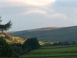
- where there are several cairns, and a small unnamed tarn
. (This small tarn can just be seen in the photograph above right).
 The name "Swarth" fell, like most of the names of geographical features in the area, is of Norse
origin: svartr, dark in colour.
Approximately 1 km south-east of the summit is the fell's other high point, Swarth Fell Pike (651 m, 2136 ft).
Baugh Fell
, Yorkshire Dales
, is 5.3 km to the south-west.
Fell
“Fell” is a word used to refer to mountains, or certain types of mountainous landscape, in Scandinavia, the Isle of Man, and parts of northern England.- Etymology :...
is an approximately 1 mile (1.5 km) stretch of high ground (consisting mainly of limestone
Limestone
Limestone is a sedimentary rock composed largely of the minerals calcite and aragonite, which are different crystal forms of calcium carbonate . Many limestones are composed from skeletal fragments of marine organisms such as coral or foraminifera....
capped with millstone grit
Millstone Grit
Millstone Grit is the name given to any of a number of coarse-grained sandstones of Carboniferous age which occur in the Northern England. The name derives from its use in earlier times as a source of millstones for use principally in watermills...
) situated to the south of Wild Boar Fell
Wild Boar Fell
Wild Boar Fell is a mountain in Mallerstang on the eastern edge of Cumbria, England. At , it is either the 4th highest fell in the Yorkshire Dales or the 5th, whether counting nearby High Seat or not...
, of which it is a continuation.
It is mostly within Mallerstang
Mallerstang
Mallerstang is a civil parish in the extreme east of Cumbria, and, geographically, a dale at the head of the upper Eden Valley. Originally part of Westmorland, it lies about south of the nearest town, Kirkby Stephen...
, Cumbria
Cumbria
Cumbria , is a non-metropolitan county in North West England. The county and Cumbria County Council, its local authority, came into existence in 1974 after the passage of the Local Government Act 1972. Cumbria's largest settlement and county town is Carlisle. It consists of six districts, and in...
, but the boundary between Cumbria and North Yorkshire
North Yorkshire
North Yorkshire is a non-metropolitan or shire county located in the Yorkshire and the Humber region of England, and a ceremonial county primarily in that region but partly in North East England. Created in 1974 by the Local Government Act 1972 it covers an area of , making it the largest...
runs along its length, just to the west of the highest points.
The summit, (681m, 2234 ft) which is marked by a cairn, and is listed as both a Hewitt and a Nuttall, lies 2.1 km to the south of the summit of Wild Boar Fell, the two fells being separated by a col
Mountain pass
A mountain pass is a route through a mountain range or over a ridge. If following the lowest possible route, a pass is locally the highest point on that route...
- where there are several cairns, and a small unnamed tarn
Tarn (lake)
A tarn is a mountain lake or pool, formed in a cirque excavated by a glacier. A moraine may form a natural dam below a tarn. A corrie may be called a cirque.The word is derived from the Old Norse word tjörn meaning pond...
. (This small tarn can just be seen in the photograph above right).
Old Norse
Old Norse is a North Germanic language that was spoken by inhabitants of Scandinavia and inhabitants of their overseas settlements during the Viking Age, until about 1300....
origin: svartr, dark in colour.
Approximately 1 km south-east of the summit is the fell's other high point, Swarth Fell Pike (651 m, 2136 ft).
Baugh Fell
Baugh Fell
Baugh Fell is a large, flat-topped hill in the northern Pennines of England. It lies in the north-western corner of the Yorkshire Dales National Park, immediately to the east of the Howgill Fells and to the north of Whernside, the highest of the Yorkshire Three Peaks...
, Yorkshire Dales
Yorkshire Dales
The Yorkshire Dales is the name given to an upland area in Northern England.The area lies within the historic county boundaries of Yorkshire, though it spans the ceremonial counties of North Yorkshire, West Yorkshire and Cumbria...
, is 5.3 km to the south-west.