

Aisgill
Encyclopedia

Mallerstang
Mallerstang is a civil parish in the extreme east of Cumbria, and, geographically, a dale at the head of the upper Eden Valley. Originally part of Westmorland, it lies about south of the nearest town, Kirkby Stephen...
in the English
England
England is a country that is part of the United Kingdom. It shares land borders with Scotland to the north and Wales to the west; the Irish Sea is to the north west, the Celtic Sea to the south west, with the North Sea to the east and the English Channel to the south separating it from continental...
county of Cumbria
Cumbria
Cumbria , is a non-metropolitan county in North West England. The county and Cumbria County Council, its local authority, came into existence in 1974 after the passage of the Local Government Act 1972. Cumbria's largest settlement and county town is Carlisle. It consists of six districts, and in...
. It is on the B6259 road, at the head of Mallerstang dale
Valley
In geology, a valley or dale is a depression with predominant extent in one direction. A very deep river valley may be called a canyon or gorge.The terms U-shaped and V-shaped are descriptive terms of geography to characterize the form of valleys...
, just before the boundary between Cumbria and North Yorkshire
North Yorkshire
North Yorkshire is a non-metropolitan or shire county located in the Yorkshire and the Humber region of England, and a ceremonial county primarily in that region but partly in North East England. Created in 1974 by the Local Government Act 1972 it covers an area of , making it the largest...
.
The highest waterfall on the River Eden
River Eden, Cumbria
The River Eden is a river that flows through Cumbria, England on its way to the Solway Firth.-Course of river:The Eden rises in Black Fell Moss, Mallerstang, on the high ground between High Seat, Yorkshire Dales and Hugh Seat. Here it forms the boundary between the counties of Cumbria and North...
, Hellgill Force, with a drop of about 20 m (65.6 ft) is just to the north, at . The river itself rises (at first as Red Gill beck, later becoming Hell Gill beck) below Hugh Seat
Hugh Seat
Hugh Seat is a mountain, or more accurately a fell, in Mallerstang on the eastern edge of Cumbria, England. It lies on the present border between Cumbria and the Yorkshire Dales National Park....
in the peat bogs above here. It finally becomes the river Eden after merging with the Ais Gill beck, which flows down from Wild Boar Fell
Wild Boar Fell
Wild Boar Fell is a mountain in Mallerstang on the eastern edge of Cumbria, England. At , it is either the 4th highest fell in the Yorkshire Dales or the 5th, whether counting nearby High Seat or not...
.
Aisgill is at both a county and a natural geographical boundary. It is at the watershed (sometimes called "the watershed of England") from which the Eden flows north towards the Irish Sea
Irish Sea
The Irish Sea separates the islands of Ireland and Great Britain. It is connected to the Celtic Sea in the south by St George's Channel, and to the Atlantic Ocean in the north by the North Channel. Anglesey is the largest island within the Irish Sea, followed by the Isle of Man...
via the Solway Firth
Solway Firth
The Solway Firth is a firth that forms part of the border between England and Scotland, between Cumbria and Dumfries and Galloway. It stretches from St Bees Head, just south of Whitehaven in Cumbria, to the Mull of Galloway, on the western end of Dumfries and Galloway. The Isle of Man is also very...
, while the River Ure
River Ure
The River Ure is a river in North Yorkshire, England, approximately long from its source to the point where it changes name to the River Ouse. It is the principal river of Wensleydale, which is the only one of the Dales now named after a village rather than its river...
flows south towards Wensleydale
Wensleydale
Wensleydale is the valley of the River Ure on the east side of the Pennines in North Yorkshire, England.Wensleydale lies in the Yorkshire Dales National Park – one of only a few valleys in the Dales not currently named after its principal river , but the older name, "Yoredale", can still be seen...
, and eventually into the North Sea
North Sea
In the southwest, beyond the Straits of Dover, the North Sea becomes the English Channel connecting to the Atlantic Ocean. In the east, it connects to the Baltic Sea via the Skagerrak and Kattegat, narrow straits that separate Denmark from Norway and Sweden respectively...
.
Swarth Fell
Swarth Fell
Swarth Fell is an approximately 1 mile stretch of high ground situated to the south of Wild Boar Fell, of which it is a continuation...
frames the western side of the head of Mallerstang dale
Valley
In geology, a valley or dale is a depression with predominant extent in one direction. A very deep river valley may be called a canyon or gorge.The terms U-shaped and V-shaped are descriptive terms of geography to characterize the form of valleys...
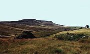
, and from Aisgill there is a view along the steep, narrow valley, with Mallerstang Edge and High Seat
High Seat (Yorkshire Dales)
High Seat is a fell in the dale of Mallerstang, Cumbria. With a summit at 709 metres, it is the fourth highest fell in the Yorkshire Dales, although outside the National Park, after Whernside, Ingleborough and Great Shunner Fell...
framing the eastern side. But the view at Aisgill is dominated by the great table-top bulk of Wild Boar Fell, to the south-west.
The Settle-Carlisle Railway
Settle-Carlisle Railway
The Settle–Carlisle Line is a long main railway line in northern England. It is also known as the Settle and Carlisle. It is a part of the National Rail network and was constructed in the 1870s...
reaches its highest point at "Aisgill Summit" 356 m (1,168 ft); and there is a small viaduct where the line crosses Ais Gill beck. There have been three notable rail accidents nearby: the Hawes Junction rail crash
Hawes Junction rail crash
The Hawes Junction rail crash occurred on 24 December 1910, on the Midland Railway's Settle and Carlisle mainline at the junction with the Wensleydale Railway in Westmorland , England. It was caused when a busy signalman forgot about a pair of light engines waiting at his down starting signal to...
in 1910, one in 1913 and most recently in 1995.
External links & References
- A Virtual Walk through Mallerstang
- Commemoration of those who died on this section of the Settle-Carlisle railway
A. Wainwright, Wainwright in the Limestone Dales, Guild Publishing, 1991 (pages 16-17)