
Virginia State Route 7
Encyclopedia
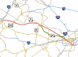
State Route 7 is a major primary state highway
and busy commuter
route in Northern Virginia
, United States
. It travels southeast from downtown
Winchester
to State Route 400
(Washington Street) in downtown Alexandria
. Its route largely parallels those of the Washington & Old Dominion Trail
(W&OD Trail) and the Potomac River
.
of Winchester, as E. Piccadilly Street at an intersection with U.S. Route 11
and U.S. Route 522
, and continues through the east end of the city, along N. East Lane, National Avenue, and finally Berryville Avenue. It exits the city into surrounding Frederick County
, where it changes names to Berryville Pike and becomes a four-lane highway. It continues across Interstate 81
, into Clarke County
.
. Business Route 7 splits off just west of Berryville and passes through the town, while the main route bypasses the town to the north. Both routes cross U.S. Route 340
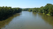
, and Business Route 7 rejoins Route 7 just east of the town. Route 7 crosses the Shenandoah River
and changes names to Harry Flood Byrd
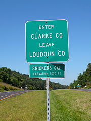
Highway. It crosses the Loudoun-Clarke County line and the Appalachian Trail
at the summit of Snickers Gap
in the Blue Ridge Mountains
.
 Route 7 enters rural western Loudoun County as Harry Flood Byrd Highway at Snickers Gap, and descends the Blue Ridge. It crosses the Snickersville Turnpike
, passes through the village of Bluemont
(formerly Snickersville), and curves around Jefferson County, West Virginia
.
It becomes a divided, limited-access highway with a 55 mi/h speed limit just west of the town of Round Hill
, where another Business Route 7 splits off to serve the towns of Round Hill
, Purcellville
, and Hamilton
, while the main road continues past the towns as a bypass. Business Route 7 rejoins the main road at the interchange with State Route 9
in Paeonian Springs
.
Route 7 continues towards the developed eastern end of Loudoun County as a four-lane divided highway with some at-grade intersections, and passes through Clarke's Gap in Catoctin Mountain
. Another Business 7 splits off on the western side of the town of Leesburg
, the county seat
of Loudoun County. The main road continues as the Leesburg Bypass, and merges with the U.S. Route 15
bypass around the southern half of the town, while the business route passes through Leesburg as Market Street and intersects Business Route 15 (King Street) at the county courthouse
in the center of the town.
The Virginia Department of Transportation
((VDOT)) has plans to widen the segment of Route 7 between State Route 9 and E. Market Street, however, due to budget cutbacks, this project was put on hold on June 6, 2008.
The bypass crosses the W&OD Trail
just before the US 15 Bypass splits off from Route 7 on the east side of downtown Leesburg, and Business Route 7 rejoins the main road at the same point. Route 7 continues on through the eastern end of Leesburg, crosses Goose Creek
, widens to six lanes, and passes through Ashburn
. Route 7 is planned as a freeway
through this portion of the county. To accomplish this, interchanges
will be constructed to replace the signalized intersections at Loudoun County Parkway
(under construction), Ashburn Village Boulevard, Belmont Ridge Road, and Battlefield Parkway. Additional overpass
es will be constructed at Lexington Drive in Ashburn and Sycolin Road in Leesburg.
Route 7 passes by numerous subdivisions
and strip mall
s before its interchange with State Route 28
. Route 7 exits Loudoun County in Sterling
, narrowing to four lanes.
, where it is mainly a suburban route. It enters Fairfax County at the interchange with the Fairfax County Parkway
(State Route 7100) and Algonkian Parkway. It continues through Fairfax County, passing by subdivisions and strip malls. It passes through Tysons Corner
, where it intersects State Route 123
and State Route 267
, the Dulles Access and Toll Roads.
It then intersects the Capital Beltway (Interstate 495
) in McLean
and
intersects Interstate 66
a half mile west of the West Falls Church Metro station.
Route 7 then enters the City of Falls Church
and becomes Broad Street. The road intersects U.S. Route 29
in the city's center and crosses the W&OD Trail in the city's west end. Route 7 then re-enters Fairfax County as Leesburg Pike and passes through Seven Corners
, named for the five roads that intersect, including U.S. Route 50
, which is grade separated
from the rest of the intersection. From there, it travels to Bailey's Crossroads
, where it intersects State Route 244
(Columbia Pike).
from Fairfax County and briefly forms the border between the Alexandria and Arlington County
, and then intersects Interstate 395. It continues as King Street through Alexandria, passing by T. C. Williams High School
, George Washington Masonic National Memorial
, Union Station (Amtrak
and Virginia Railway Express
), and the King Street – Old Town Metro station. Route 7 ends at the intersection
of King Street and Washington Street in Old Town Alexandria, one quarter of a mile west of the Potomac River.
{| class="wikitable"
|-
!County
!Municipality
!Destination
!Notes
|-
|Frederick
|Winchester
| – Martinsburg
, Roanoke
|Not located within the city
, but near it or in its postal city.
|-
|Clarke
|Berryville
|, Charles Town, WV
|
|-
|rowspan=14|Loudoun
|Round Hill
|
|
|-
|Purcellville
|
|
|-
|Hamilton
|
|
|-
|rowspan=6|Leesburg
| – Charles Town, WV
|
|-
|
|
|-
|
|
|-
| – Dulles Airport, Washington
|
|-
| – Frederick, MD
, Leesburg
|US 15 leaves eastbound and joins westbound
|-
|
|
|-
|rowspan=2|Ashburn
|
|
|-
|
|A single-point urban interchange
is under construction. The western ramps are open, and the eastern ramps are scheduled to open to traffic in July, 2010.
|-
|rowspan=3|Sterling
| – Dulles Airport
|
|-
|
|
|-
|
|
|-
|rowspan=9|Fairfax
|rowspan=2|Dranesville
|
|
|-
|
|
|-
|rowspan=3|Tysons Corner
| – Washington, Dulles Airport
|
|-
|
|
|-
|, Baltimore, MD
|
|-
|Falls Church
| – Washington, Front Royal
|Not located within the city
, but near it or in its postal city.
|-
|rowspan=2|Seven Corners
|
|
|-
| – Washington, Centreville
|
|-
|Bailey's Crossroads
|
|
|-
|colspan=2|City
of Alexandria
| – Washington, Springfield
|
|
Additional interchanges are planned at Ashburn Village Boulevard in Ashburn, Belmont Ridge Road in Ashburn, and Battlefield Parkway in Leesburg.
Route 7 splits into business and bypass routes three times in Loudoun County
: Leesburg
, Purcellville
, and Round Hill
and once in Clarke County for the town of Berryville
.
West of Interstate 395, Route 7 is part of the National Highway System
.
State highway
State highway, state road or state route can refer to one of three related concepts, two of them related to a state or provincial government in a country that is divided into states or provinces :#A...
and busy commuter
Commuting
Commuting is regular travel between one's place of residence and place of work or full time study. It sometimes refers to any regular or often repeated traveling between locations when not work related.- History :...
route in Northern Virginia
Northern Virginia
Northern Virginia consists of several counties and independent cities in the Commonwealth of Virginia, in a widespread region generally radiating southerly and westward from Washington, D.C...
, United States
United States
The United States of America is a federal constitutional republic comprising fifty states and a federal district...
. It travels southeast from downtown
Downtown
Downtown is a term primarily used in North America by English speakers to refer to a city's core or central business district ....
Winchester
Winchester, Virginia
Winchester is an independent city located in the northwestern portion of the Commonwealth of Virginia in the USA. The city's population was 26,203 according to the 2010 Census...
to State Route 400
Virginia State Route 400
State Route 400, also known as Washington Street, is a primary state highway in Alexandria, Virginia, United States. It runs from the south city limits north to First Street, forming a link of the George Washington Parkway and U.S. Bicycle Route 1...
(Washington Street) in downtown Alexandria
Alexandria, Virginia
Alexandria is an independent city in the Commonwealth of Virginia. As of 2009, the city had a total population of 139,966. Located along the Western bank of the Potomac River, Alexandria is approximately six miles south of downtown Washington, D.C.Like the rest of northern Virginia, as well as...
. Its route largely parallels those of the Washington & Old Dominion Trail
Washington & Old Dominion Railroad Regional Park
The Washington & Old Dominion Railroad Regional Park is a popular and unusually-shaped regional park in Northern Virginia. The park's primary feature is the Washington & Old Dominion Railroad Trail , an asphalt-surfaced paved rail trail that runs through densely populated urban and suburban...
(W&OD Trail) and the Potomac River
Potomac River
The Potomac River flows into the Chesapeake Bay, located along the mid-Atlantic coast of the United States. The river is approximately long, with a drainage area of about 14,700 square miles...
.
Frederick County and City of Winchester
Route 7 begins downtown in the CityIndependent city
An independent city is a city that does not form part of another general-purpose local government entity. These type of cities should not be confused with city-states , which are fully sovereign cities that are not part of any other sovereign state.-Historical precursors:In the Holy Roman Empire,...
of Winchester, as E. Piccadilly Street at an intersection with U.S. Route 11
U.S. Route 11
U.S. Route 11 is a north–south United States highway extending 1,645 miles across the eastern United States. The southern terminus of the route is at U.S. Route 90 in the Bayou Sauvage National Wildlife Refuge in eastern New Orleans, Louisiana. The northern terminus is at the United...
and U.S. Route 522
U.S. Route 522
U.S. Route 522 is a spur route of U.S. Route 22 in the eastern United States. The southern terminus of the route is at U.S. Route 60 in Powhatan, Virginia. The northern terminus is at U.S. Route 11 and U.S. Route 15 in Selinsgrove, Pennsylvania. US 522 passes through the states of Virginia, West...
, and continues through the east end of the city, along N. East Lane, National Avenue, and finally Berryville Avenue. It exits the city into surrounding Frederick County
Frederick County, Virginia
Frederick County is a county located in the Commonwealth of Virginia. It is included in the Winchester, Virginia-West Virginia Metropolitan Statistical Area. It was formed in 1743 by the splitting of Orange County. For ten years it was the home of George Washington. As of 2010, the population was...
, where it changes names to Berryville Pike and becomes a four-lane highway. It continues across Interstate 81
Interstate 81
Interstate 81 is an Interstate Highway in the eastern part of the United States. Its southern terminus is at Interstate 40 in Dandridge, Tennessee; its northern terminus is on Wellesley Island at the Canadian border, where the Thousand Islands Bridge connects it to Highway 401, the main freeway...
, into Clarke County
Clarke County, Virginia
Clarke County is a county in the Commonwealth of Virginia. As of 2010, the population was 14,034. Its county seat is Berryville.-History:Clarke County was established in 1836 by Thomas Fairfax, 6th Lord Fairfax of Cameron who built a home, Greenway Court, on part of his 5 million acre property,...
.
Clarke County
Route 7 enters from Frederick County, crossing the Opequon Creek, and continues towards the town of BerryvilleBerryville, Virginia
Berryville is an incorporated town in and the county seat of Clarke County, Virginia, United States. The population was 2,963 at the 2000 census.-Geography:...
. Business Route 7 splits off just west of Berryville and passes through the town, while the main route bypasses the town to the north. Both routes cross U.S. Route 340
U.S. Route 340
U.S. Route 340 is a spur of US 40. It currently runs for from Greenville, Virginia at US 11 to Frederick, Maryland at US 40. Between those two states, US 340 also passes briefly through West Virginia. In Virginia and West Virginia, it is signed north–south...
, and Business Route 7 rejoins Route 7 just east of the town. Route 7 crosses the Shenandoah River
Shenandoah River
The Shenandoah River is a tributary of the Potomac River, long with two forks approximately long each, in the U.S. states of Virginia and West Virginia...
and changes names to Harry Flood Byrd
Harry F. Byrd
Harry Flood Byrd, Sr. of Berryville in Clarke County, Virginia, was an American newspaper publisher, farmer and politician. He was a descendant of one of the First Families of Virginia...
Highway. It crosses the Loudoun-Clarke County line and the Appalachian Trail
Appalachian Trail
The Appalachian National Scenic Trail, generally known as the Appalachian Trail or simply the AT, is a marked hiking trail in the eastern United States extending between Springer Mountain in Georgia and Mount Katahdin in Maine. It is approximately long...
at the summit of Snickers Gap
Snickers Gap
Snickers Gap, originally William's Gap, is a wind gap in the Blue Ridge Mountain on the border of Loudoun County and Clarke County in Virginia. The gap is traversed by Virginia State Route 7. The Appalachian Trail also passes across the gap...
in the Blue Ridge Mountains
Blue Ridge Mountains
The Blue Ridge Mountains are a physiographic province of the larger Appalachian Mountains range. This province consists of northern and southern physiographic regions, which divide near the Roanoke River gap. The mountain range is located in the eastern United States, starting at its southern-most...
.
Loudoun County
Snicker's Gap Turnpike
The Snicker's Gap Turnpike was a turnpike road in the northern part of the U.S. state of Virginia. Part of it is now maintained as State Route 7, a primary state highway, but the road between Aldie and Bluemont in Loudoun County, via Mountville, Philomont, and Airmont, is a rural Virginia Byway...
, passes through the village of Bluemont
Bluemont, Virginia
Bluemont is an unincorporated village in Loudoun County, Virginia located at the base of Snickers Gap in the Blue Ridge Mountain. At 680 feet , it is the highest community in Loudoun County...
(formerly Snickersville), and curves around Jefferson County, West Virginia
Jefferson County, West Virginia
Jefferson County is a county located in the U.S. state of West Virginia. As of 2010, the population was 53,498. Its county seat is Charles Town...
.
It becomes a divided, limited-access highway with a 55 mi/h speed limit just west of the town of Round Hill
Round Hill, Virginia
Round Hill is the name of several communities in the U.S. state of Virginia.*Round Hill, Frederick County, Virginia*Round Hill, Loudoun County, Virginia *Round Hill, Rappahannock County, Virginia...
, where another Business Route 7 splits off to serve the towns of Round Hill
Round Hill, Virginia
Round Hill is the name of several communities in the U.S. state of Virginia.*Round Hill, Frederick County, Virginia*Round Hill, Loudoun County, Virginia *Round Hill, Rappahannock County, Virginia...
, Purcellville
Purcellville, Virginia
Purcellville is a town in the Loudoun Valley of Loudoun County, Virginia, United States. The population was 3,584 at the 2000 census, but has undergone considerable growth since then. Purcellville is the major population center for western Loudoun and the Loudoun Valley...
, and Hamilton
Hamilton, Virginia
Hamilton is a town in the Loudoun Valley of Loudoun County, Virginia, United States. The population was 562 as of the 2000 census.-Geography:...
, while the main road continues past the towns as a bypass. Business Route 7 rejoins the main road at the interchange with State Route 9
Virginia State Route 9
Virginia State Route 9 is a primary state highway in the U.S. state of Virginia. Known as Charles Town Pike, the state highway runs from the West Virginia state line near Mechanicsville, where the highway continues west as West Virginia Route 9 , east to SR 7 and SR 7 Business near Paeonian...
in Paeonian Springs
Paeonian Springs, Virginia
Paeonian Springs is an unincorporated community in Loudoun County, Virginia, USA. It is located on the Charles Town Pike near its intersection with the Harry Byrd Highway . Paeonian Springs was established in 1890 and is currently served by a post office.- External links :*...
.
Route 7 continues towards the developed eastern end of Loudoun County as a four-lane divided highway with some at-grade intersections, and passes through Clarke's Gap in Catoctin Mountain
Catoctin Mountain
Catoctin Mountain, along with the geologically associated Bull Run Mountains, comprises the easternmost mountain ridge of the Blue Ridge Mountains, which are in turn a part of the Appalachian Mountains range...
. Another Business 7 splits off on the western side of the town of Leesburg
Leesburg, Virginia
Leesburg is a historic town in, and county seat of, Loudoun County, Virginia, United States of America. Leesburg is located west-northwest of Washington, D.C. along the base of the Catoctin Mountain and adjacent to the Potomac River. Its population according the 2010 Census is 42,616...
, the county seat
County seat
A county seat is an administrative center, or seat of government, for a county or civil parish. The term is primarily used in the United States....
of Loudoun County. The main road continues as the Leesburg Bypass, and merges with the U.S. Route 15
U.S. Route 15
U.S. Route 15 is a -long United States highway, designated along South Carolina, North Carolina, Virginia, Maryland, Pennsylvania, and New York. The route is signed north–south, from U.S. Route 17 Alternate in Walterboro, South Carolina to Interstate 86 and NY 17 in Painted Post, New York.US...
bypass around the southern half of the town, while the business route passes through Leesburg as Market Street and intersects Business Route 15 (King Street) at the county courthouse
Courthouse
A courthouse is a building that is home to a local court of law and often the regional county government as well, although this is not the case in some larger cities. The term is common in North America. In most other English speaking countries, buildings which house courts of law are simply...
in the center of the town.
The Virginia Department of Transportation
Virginia Department of Transportation
The Virginia Department of Transportation is the agency of state government responsible for transportation in the state of Virginia in the United States. Headquartered in Downtown Richmond, VDOT is responsible for building, maintaining, and operating the roads, bridges and tunnels in the...
((VDOT)) has plans to widen the segment of Route 7 between State Route 9 and E. Market Street, however, due to budget cutbacks, this project was put on hold on June 6, 2008.
The bypass crosses the W&OD Trail
Washington & Old Dominion Railroad Regional Park
The Washington & Old Dominion Railroad Regional Park is a popular and unusually-shaped regional park in Northern Virginia. The park's primary feature is the Washington & Old Dominion Railroad Trail , an asphalt-surfaced paved rail trail that runs through densely populated urban and suburban...
just before the US 15 Bypass splits off from Route 7 on the east side of downtown Leesburg, and Business Route 7 rejoins the main road at the same point. Route 7 continues on through the eastern end of Leesburg, crosses Goose Creek
Goose Creek (Potomac River)
Goose Creek is a tributary of the Potomac River in Fauquier and Loudoun counties in northern Virginia. It comprises the principal drainage system for the Loudoun Valley.-Course:...
, widens to six lanes, and passes through Ashburn
Ashburn, Virginia
Ashburn, Virginia is a census-designated place located in Loudoun County, Virginia, northwest of Washington, D.C., and is part of the Washington Metropolitan Area...
. Route 7 is planned as a freeway
Controlled-access highway
A controlled-access highway is a highway designed exclusively for high-speed vehicular traffic, with all traffic flow and ingress/egress regulated...
through this portion of the county. To accomplish this, interchanges
Interchange (road)
In the field of road transport, an interchange is a road junction that typically uses grade separation, and one or more ramps, to permit traffic on at least one highway to pass through the junction without directly crossing any other traffic stream. It differs from a standard intersection, at which...
will be constructed to replace the signalized intersections at Loudoun County Parkway
Loudoun County Parkway
The Loudoun County Parkway is a secondary state highway in eastern Loudoun County, Virginia. Two sections of the route currently exist, a southern portion signed as State Route 606 from Braddock Road north to Arcola Road which continues east as Old Ox Road, and a northern portion in Ashburn signed...
(under construction), Ashburn Village Boulevard, Belmont Ridge Road, and Battlefield Parkway. Additional overpass
Overpass
An overpass is a bridge, road, railway or similar structure that crosses over another road or railway...
es will be constructed at Lexington Drive in Ashburn and Sycolin Road in Leesburg.
Route 7 passes by numerous subdivisions
Subdivision (land)
Subdivision is the act of dividing land into pieces that are easier to sell or otherwise develop, usually via a plat. The former single piece as a whole is then known in the United States as a subdivision...
and strip mall
Strip mall
A strip mall is an open-area shopping center where the stores are arranged in a row, with a sidewalk in front. Strip malls are typically developed as a unit and have large parking lots in front...
s before its interchange with State Route 28
Virginia State Route 28
State Route 28 is a primary state highway that traverses the counties of Loudoun, Fairfax, Prince William, and Fauquier in the U.S. state of Virginia. It is a major artery through Northern Virginia.-Loudoun County:...
. Route 7 exits Loudoun County in Sterling
Sterling, Virginia
Sterling, Virginia is a census-designated place in Loudoun County, Virginia. The population as of the 2010 Census was 27,822.It is located northwest of Herndon, east of Ashburn, and west of Great Falls, and includes part of Dulles International Airport and the former AOL corporate headquarters...
, narrowing to four lanes.
Fairfax County and City of Falls Church
Route 7 is known as Leesburg Pike throughout Fairfax CountyFairfax County, Virginia
Fairfax County is a county in Virginia, in the United States. Per the 2010 Census, the population of the county is 1,081,726, making it the most populous jurisdiction in the Commonwealth of Virginia, with 13.5% of Virginia's population...
, where it is mainly a suburban route. It enters Fairfax County at the interchange with the Fairfax County Parkway
Fairfax County Parkway
The Fairfax County Parkway, signed as State Route 7100, is a secondary state highway in the U.S. state of Virginia. It provides a north–south arterial route in Fairfax County with a mix of interchanges and signalized and unsignalized intersections. Its alignment roughly corresponds to part of...
(State Route 7100) and Algonkian Parkway. It continues through Fairfax County, passing by subdivisions and strip malls. It passes through Tysons Corner
Tysons Corner, Virginia
Tysons Corner is an unincorporated census-designated place in Fairfax County, Virginia, United States. Part of the Washington Metropolitan Area located in Northern Virginia, Tysons Corner lies between the community of McLean and the town of Vienna along the Capital Beltway . The population was...
, where it intersects State Route 123
Virginia State Route 123
Virginia State Route 123 is a primary state highway in the U.S. state of Virginia. The state highway runs from U.S. Route 1 in Woodbridge north to the Chain Bridge across the Potomac River into Washington from Arlington...
and State Route 267
Virginia State Route 267
State Route 267 is a primary state highway in the U.S. state of Virginia. It consists of two end-to-end toll roads – the Dulles Toll Road and Dulles Greenway – as well as the Dulles Access Road,...
, the Dulles Access and Toll Roads.
It then intersects the Capital Beltway (Interstate 495
Interstate 495 (Capital Beltway)
Interstate 495 is a Interstate Highway that surrounds the United States' capital of Washington, D.C., and its inner suburbs in adjacent Maryland and Virginia. I-495 is widely known as the Capital Beltway or simply the Beltway, especially when the context of Washington, D.C., is clear...
) in McLean
McLean, Virginia
McLean is an unincorporated community and census-designated place in Fairfax County in Northern Virginia. The community had a total population of 48,115 as of the 2010 census....
and
intersects Interstate 66
Interstate 66
Interstate 66 is an Interstate Highway in the eastern United States. As indicated by its even route number, it runs in an east–west direction. Its western terminus is at Middletown, Virginia, at an intersection with Interstate 81; its eastern terminus is in Washington, D.C., at an...
a half mile west of the West Falls Church Metro station.
Route 7 then enters the City of Falls Church
Falls Church, Virginia
The City of Falls Church is an independent city in Virginia, United States, in the Washington Metropolitan Area. The city population was 12,332 in 2010, up from 10,377 in 2000. Taking its name from The Falls Church, an 18th-century Anglican parish, Falls Church gained township status within...
and becomes Broad Street. The road intersects U.S. Route 29
U.S. Route 29
U.S. Route 29 is a north–south United States highway that runs for from the western suburbs of Baltimore, Maryland, to Pensacola, Florida. This highway's northern terminus is at Maryland Route 99 in Ellicott City, Maryland...
in the city's center and crosses the W&OD Trail in the city's west end. Route 7 then re-enters Fairfax County as Leesburg Pike and passes through Seven Corners
Seven Corners, Virginia
Seven Corners is a commercial center and census-designated place in Fairfax County, Virginia, United States. The population was 8,701 at the 2000 census. Seven Corners has a "Falls Church" mailing address but is not within the independent City of Falls Church, Virginia. The area got its name...
, named for the five roads that intersect, including U.S. Route 50
U.S. Route 50
U.S. Route 50 is a major east–west route of the U.S. Highway system, stretching just over from Ocean City, Maryland on the Atlantic Ocean to West Sacramento, California. Until 1972, when it was replaced by Interstate Highways west of the Sacramento area, it extended to San Francisco, near...
, which is grade separated
Grade separation
Grade separation is the method of aligning a junction of two or more transport axes at different heights so that they will not disrupt the traffic flow on other transit routes when they cross each other. The composition of such transport axes does not have to be uniform; it can consist of a...
from the rest of the intersection. From there, it travels to Bailey's Crossroads
Bailey's Crossroads, Virginia
Bailey's Crossroads is an unincorporated community and census-designated place in Fairfax County, Virginia, United States. The population was 23,643 at the 2010 census...
, where it intersects State Route 244
Virginia State Route 244
State Route 244, also known as Columbia Pike, is a primary state highway in the U.S. state of Virginia. It is a four-lane road that runs from State Route 236 in Annandale, Fairfax County east to State Route 27 at the Pentagon in Arlington County.-History:Columbia Pike dates to 1810 when the U.S...
(Columbia Pike).
City of Alexandria
Route 7 enters the City of AlexandriaAlexandria, Virginia
Alexandria is an independent city in the Commonwealth of Virginia. As of 2009, the city had a total population of 139,966. Located along the Western bank of the Potomac River, Alexandria is approximately six miles south of downtown Washington, D.C.Like the rest of northern Virginia, as well as...
from Fairfax County and briefly forms the border between the Alexandria and Arlington County
Arlington County, Virginia
Arlington County is a county in the Commonwealth of Virginia. The land that became Arlington was originally donated by Virginia to the United States government to form part of the new federal capital district. On February 27, 1801, the United States Congress organized the area as a subdivision of...
, and then intersects Interstate 395. It continues as King Street through Alexandria, passing by T. C. Williams High School
T. C. Williams High School
T. C. Williams High School is a public high school in Alexandria, Virginia, named after former superintendent Thomas Chambliss Williams of Alexandria City Public Schools who served from the mid-1930s to the mid-1960s...
, George Washington Masonic National Memorial
George Washington Masonic National Memorial
George Washington Masonic National Memorial is a Masonic building and memorial located in Alexandria, Virginia, outside Washington, D.C.. It is dedicated to the memory of George Washington, the first President of the United States and a Mason. The tower is fashioned after the ancient Lighthouse of...
, Union Station (Amtrak
Amtrak
The National Railroad Passenger Corporation, doing business as Amtrak , is a government-owned corporation that was organized on May 1, 1971, to provide intercity passenger train service in the United States. "Amtrak" is a portmanteau of the words "America" and "track". It is headquartered at Union...
and Virginia Railway Express
Virginia Railway Express
The Virginia Railway Express is a regional/ commuter rail service that connects the Northern Virginia suburbs to Union Station in Washington, D.C., via two lines: the Fredericksburg Line from Fredericksburg, Virginia, and the Manassas Line from Broad Run/Airport station in Bristow,...
), and the King Street – Old Town Metro station. Route 7 ends at the intersection
Intersection (road)
An intersection is a road junction where two or more roads either meet or cross at grade . An intersection may be 3-way - a T junction or fork, 4-way - a crossroads, or 5-way or more...
of King Street and Washington Street in Old Town Alexandria, one quarter of a mile west of the Potomac River.
Major intersections
In addition to numerous at-grade intersections, Route 7 has off-level interchanges with the following routes:{| class="wikitable"
|-
!County
!Municipality
!Destination
!Notes
|-
|Frederick
Frederick County, Virginia
Frederick County is a county located in the Commonwealth of Virginia. It is included in the Winchester, Virginia-West Virginia Metropolitan Statistical Area. It was formed in 1743 by the splitting of Orange County. For ten years it was the home of George Washington. As of 2010, the population was...
|Winchester
Winchester, Virginia
Winchester is an independent city located in the northwestern portion of the Commonwealth of Virginia in the USA. The city's population was 26,203 according to the 2010 Census...
| – Martinsburg
Martinsburg, West Virginia
Martinsburg is a city in the Eastern Panhandle region of West Virginia, United States. The city's population was 14,972 at the 2000 census; according to a 2009 Census Bureau estimate, Martinsburg's population was 17,117, making it the largest city in the Eastern Panhandle and the eighth largest...
, Roanoke
Roanoke, Virginia
Roanoke is an independent city in the Mid-Atlantic U.S. state of Virginia and is the tenth-largest city in the Commonwealth. It is located in the Roanoke Valley of the Roanoke Region of Virginia. The population within the city limits was 97,032 as of 2010...
|Not located within the city
Independent city
An independent city is a city that does not form part of another general-purpose local government entity. These type of cities should not be confused with city-states , which are fully sovereign cities that are not part of any other sovereign state.-Historical precursors:In the Holy Roman Empire,...
, but near it or in its postal city.
|-
|Clarke
Clarke County, Virginia
Clarke County is a county in the Commonwealth of Virginia. As of 2010, the population was 14,034. Its county seat is Berryville.-History:Clarke County was established in 1836 by Thomas Fairfax, 6th Lord Fairfax of Cameron who built a home, Greenway Court, on part of his 5 million acre property,...
|Berryville
Berryville, Virginia
Berryville is an incorporated town in and the county seat of Clarke County, Virginia, United States. The population was 2,963 at the 2000 census.-Geography:...
|, Charles Town, WV
Charles Town, West Virginia
Charles Town is a city in and the county seat of Jefferson County, West Virginia, United States. The population was 2,907 at the 2000 census. Due to its similar name, travelers have sometimes confused this city with the state's capital, Charleston.-History:...
|
|-
|rowspan=14|Loudoun
Loudoun County, Virginia
Loudoun County is a county located in the Commonwealth of Virginia, and is part of the Washington Metropolitan Area. As of the 2010 U.S. Census, the county is estimated to be home to 312,311 people, an 84 percent increase over the 2000 figure of 169,599. That increase makes the county the fourth...
|Round Hill
Round Hill, Virginia
Round Hill is the name of several communities in the U.S. state of Virginia.*Round Hill, Frederick County, Virginia*Round Hill, Loudoun County, Virginia *Round Hill, Rappahannock County, Virginia...
|
|
|-
|Purcellville
Purcellville, Virginia
Purcellville is a town in the Loudoun Valley of Loudoun County, Virginia, United States. The population was 3,584 at the 2000 census, but has undergone considerable growth since then. Purcellville is the major population center for western Loudoun and the Loudoun Valley...
|
|
|-
|Hamilton
Hamilton, Virginia
Hamilton is a town in the Loudoun Valley of Loudoun County, Virginia, United States. The population was 562 as of the 2000 census.-Geography:...
|
|
|-
|rowspan=6|Leesburg
Leesburg, Virginia
Leesburg is a historic town in, and county seat of, Loudoun County, Virginia, United States of America. Leesburg is located west-northwest of Washington, D.C. along the base of the Catoctin Mountain and adjacent to the Potomac River. Its population according the 2010 Census is 42,616...
| – Charles Town, WV
Charles Town, West Virginia
Charles Town is a city in and the county seat of Jefferson County, West Virginia, United States. The population was 2,907 at the 2000 census. Due to its similar name, travelers have sometimes confused this city with the state's capital, Charleston.-History:...
|
|-
|
|
|-
|
|
|-
| – Dulles Airport, Washington
|
|-
| – Frederick, MD
Frederick, Maryland
Frederick is a city in north-central Maryland. It is the county seat of Frederick County, the largest county by area in the state of Maryland. Frederick is an outlying community of the Washington-Arlington-Alexandria, DC-VA-MD-WV Metropolitan Statistical Area, which is part of a greater...
, Leesburg
Leesburg, Virginia
Leesburg is a historic town in, and county seat of, Loudoun County, Virginia, United States of America. Leesburg is located west-northwest of Washington, D.C. along the base of the Catoctin Mountain and adjacent to the Potomac River. Its population according the 2010 Census is 42,616...
|US 15 leaves eastbound and joins westbound
|-
|
|
|-
|rowspan=2|Ashburn
Ashburn, Virginia
Ashburn, Virginia is a census-designated place located in Loudoun County, Virginia, northwest of Washington, D.C., and is part of the Washington Metropolitan Area...
|
|
|-
|
|A single-point urban interchange
Single-point urban interchange
A single-point urban interchange , also called a single-point interchange or single-point diamond interchange , is a type of highway interchange...
is under construction. The western ramps are open, and the eastern ramps are scheduled to open to traffic in July, 2010.
|-
|rowspan=3|Sterling
Sterling, Virginia
Sterling, Virginia is a census-designated place in Loudoun County, Virginia. The population as of the 2010 Census was 27,822.It is located northwest of Herndon, east of Ashburn, and west of Great Falls, and includes part of Dulles International Airport and the former AOL corporate headquarters...
| – Dulles Airport
|
|-
|
|
|-
|
|
|-
|rowspan=9|Fairfax
Fairfax County, Virginia
Fairfax County is a county in Virginia, in the United States. Per the 2010 Census, the population of the county is 1,081,726, making it the most populous jurisdiction in the Commonwealth of Virginia, with 13.5% of Virginia's population...
|rowspan=2|Dranesville
Dranesville, Virginia
Dranesville is an unincorporated community in Fairfax County, Virginia, USA. Dranesville is located on the Leesburg Pike at its intersection with Georgetown Pike. The Census Bureau defines Dranesville as a census-designated place with a population of 11,921 as of 2010...
|
|
|-
|
|
|-
|rowspan=3|Tysons Corner
Tysons Corner, Virginia
Tysons Corner is an unincorporated census-designated place in Fairfax County, Virginia, United States. Part of the Washington Metropolitan Area located in Northern Virginia, Tysons Corner lies between the community of McLean and the town of Vienna along the Capital Beltway . The population was...
| – Washington, Dulles Airport
|
|-
|
|
|-
|, Baltimore, MD
|
|-
|Falls Church
Falls Church, Virginia
The City of Falls Church is an independent city in Virginia, United States, in the Washington Metropolitan Area. The city population was 12,332 in 2010, up from 10,377 in 2000. Taking its name from The Falls Church, an 18th-century Anglican parish, Falls Church gained township status within...
| – Washington, Front Royal
Front Royal, Virginia
Front Royal is a town in Warren County, Virginia, United States. The population was 13,589 at the 2000 census. It is the county seat of Warren County.-Geography:Front Royal is roughly west of Washington, D.C....
|Not located within the city
Independent city
An independent city is a city that does not form part of another general-purpose local government entity. These type of cities should not be confused with city-states , which are fully sovereign cities that are not part of any other sovereign state.-Historical precursors:In the Holy Roman Empire,...
, but near it or in its postal city.
|-
|rowspan=2|Seven Corners
|
|
|-
| – Washington, Centreville
Centreville, Virginia
Centreville is an unincorporated community in Fairfax County, Virginia, United States. Recognized by the U.S. Census Bureau as a Census Designated Place , the community population was 71,135 as of the 2010 census and is approximately west of Washington, DC.-Colonial Period:Beginning in the 1760s,...
|
|-
|Bailey's Crossroads
|
|
|-
|colspan=2|
Independent city
An independent city is a city that does not form part of another general-purpose local government entity. These type of cities should not be confused with city-states , which are fully sovereign cities that are not part of any other sovereign state.-Historical precursors:In the Holy Roman Empire,...
of Alexandria
Alexandria, Virginia
Alexandria is an independent city in the Commonwealth of Virginia. As of 2009, the city had a total population of 139,966. Located along the Western bank of the Potomac River, Alexandria is approximately six miles south of downtown Washington, D.C.Like the rest of northern Virginia, as well as...
| – Washington, Springfield
Springfield, Virginia
Springfield is a census-designated place in Fairfax County, Virginia, United States and a suburb of Washington, D.C. The Springfield CDP is recognized by the U.S. Census Bureau with a population of 30,484 as of the 2010 census. Homes and businesses in bordering CDPs including North Springfield,...
|
|
Additional interchanges are planned at Ashburn Village Boulevard in Ashburn, Belmont Ridge Road in Ashburn, and Battlefield Parkway in Leesburg.
Route 7 splits into business and bypass routes three times in Loudoun County
Loudoun County, Virginia
Loudoun County is a county located in the Commonwealth of Virginia, and is part of the Washington Metropolitan Area. As of the 2010 U.S. Census, the county is estimated to be home to 312,311 people, an 84 percent increase over the 2000 figure of 169,599. That increase makes the county the fourth...
: Leesburg
Leesburg, Virginia
Leesburg is a historic town in, and county seat of, Loudoun County, Virginia, United States of America. Leesburg is located west-northwest of Washington, D.C. along the base of the Catoctin Mountain and adjacent to the Potomac River. Its population according the 2010 Census is 42,616...
, Purcellville
Purcellville, Virginia
Purcellville is a town in the Loudoun Valley of Loudoun County, Virginia, United States. The population was 3,584 at the 2000 census, but has undergone considerable growth since then. Purcellville is the major population center for western Loudoun and the Loudoun Valley...
, and Round Hill
Round Hill, Virginia
Round Hill is the name of several communities in the U.S. state of Virginia.*Round Hill, Frederick County, Virginia*Round Hill, Loudoun County, Virginia *Round Hill, Rappahannock County, Virginia...
and once in Clarke County for the town of Berryville
Berryville, Virginia
Berryville is an incorporated town in and the county seat of Clarke County, Virginia, United States. The population was 2,963 at the 2000 census.-Geography:...
.
West of Interstate 395, Route 7 is part of the National Highway System
National Highway System (United States)
The National Highway System is a network of strategic highways within the United States, including the Interstate Highway System and other roads serving major airports, ports, rail or truck terminals, railway stations, pipeline terminals and other strategic transport facilities.Individual states...
.