
Snickers Gap
Encyclopedia
Snickers Gap, originally William's Gap, is a wind gap
in the Blue Ridge Mountain
on the border of Loudoun County
and Clarke County
in Virginia
. The gap is traversed by Virginia State Route 7
. The Appalachian Trail
also passes across the gap. Bear's Den and Raven Rocks
are adjacent to the gap.
During the autumn bird migration
the gap is a favored spot for birdwatchers to count and study the many raptors that follow the ridge on their way south.
, Snickers Gap is one of the lowest wind gaps of the ridge in Virginia, with only Manassas Gap
and the adjacent Keyes Gap
being lower. The gap connects the northern Virginia
piedmont with the lower Shenandoah Valley
and servers as a main thoroughfare
between the two regions.
and the Shenandoah Valley
since before the European
colonization of the area. Native Americans
originally cut a trail through the gap that continued to be used by white settlers. The gap was known as Williams' Gap until the early 1780s, when the modern name began to be used. The gap derived its name from Edward Snickers, who owned the gap and surrounding land and operated a ferry across the Shenandoah River
on the western side of the gap. By the late 18th century the Snickersville Turnpike and the Snickers Gap Turnpike were completed, and Snickers Gap became the main thoroughfare between Loudoun County
and the Shenandoah, bypassing Keyes Gap, which to that point had been the preferred route. The two turnpikes joined at Snickersville (present-day Bluemont
) and then proceeded over the gap to Winchester
. The toll at the gap persisted well into the 20th century. The Snickers Gap turnpike was eventually made into Virginia State Route 7
, and the toll was dropped. The gap was the scene of many small American Civil War
skirmishes, and part of the Battle of Cool Spring
(sometimes referred to as the "Battle of Snicker's Gap") took place there.
Wind gap
A wind gap is a valley through which a waterway once flowed, but is now dry as a result of stream capture. A water gap is a similar feature, but one in which a waterway still flows...
in the Blue Ridge Mountain
Blue Ridge Mountain
Blue Ridge Mountain, also known as Blue Mountain, is the colloquial name of the western most ridge of the Blue Ridge Mountains in northern Virginia and the Eastern Panhandle of West Virginia...
on the border of Loudoun County
Loudoun County, Virginia
Loudoun County is a county located in the Commonwealth of Virginia, and is part of the Washington Metropolitan Area. As of the 2010 U.S. Census, the county is estimated to be home to 312,311 people, an 84 percent increase over the 2000 figure of 169,599. That increase makes the county the fourth...
and Clarke County
Clarke County, Virginia
Clarke County is a county in the Commonwealth of Virginia. As of 2010, the population was 14,034. Its county seat is Berryville.-History:Clarke County was established in 1836 by Thomas Fairfax, 6th Lord Fairfax of Cameron who built a home, Greenway Court, on part of his 5 million acre property,...
in Virginia
Virginia
The Commonwealth of Virginia , is a U.S. state on the Atlantic Coast of the Southern United States. Virginia is nicknamed the "Old Dominion" and sometimes the "Mother of Presidents" after the eight U.S. presidents born there...
. The gap is traversed by Virginia State Route 7
Virginia State Route 7
State Route 7 is a major primary state highway and busy commuter route in Northern Virginia, United States. It travels southeast from downtown Winchester to State Route 400 in downtown Alexandria...
. The Appalachian Trail
Appalachian Trail
The Appalachian National Scenic Trail, generally known as the Appalachian Trail or simply the AT, is a marked hiking trail in the eastern United States extending between Springer Mountain in Georgia and Mount Katahdin in Maine. It is approximately long...
also passes across the gap. Bear's Den and Raven Rocks
Raven Rocks
Raven Rocks is 1454 ft spur of the Blue Ridge Mountain in Jefferson County, West Virginia. The peak is located just north of Jefferson County's border with Clarke County, Virginia and west of its border with Loudoun County, Virginia....
are adjacent to the gap.
During the autumn bird migration
Bird migration
Bird migration is the regular seasonal journey undertaken by many species of birds. Bird movements include those made in response to changes in food availability, habitat or weather. Sometimes, journeys are not termed "true migration" because they are irregular or in only one direction...
the gap is a favored spot for birdwatchers to count and study the many raptors that follow the ridge on their way south.
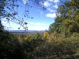
Geography
At 1056 feet (321.9 m) the gap is approximately 300 to 600 ft (91.4 to 182.9 ) below the adjacent ridge line and 400 to 600 ft (121.9 to 182.9 ) above the surrounding countryside. Due to the dwindling height of the Blue Ridge as it approaches the Potomac RiverPotomac River
The Potomac River flows into the Chesapeake Bay, located along the mid-Atlantic coast of the United States. The river is approximately long, with a drainage area of about 14,700 square miles...
, Snickers Gap is one of the lowest wind gaps of the ridge in Virginia, with only Manassas Gap
Manassas Gap
Manassas Gap is a wind gap of the Blue Ridge Mountains on the border of Fauquier County and Warren County in Virginia. At an elevation of 887 feet above sea level, it is the lowest crossing of the Blue Ridge Mountains in the state....
and the adjacent Keyes Gap
Keyes Gap
Keyes Gap or Keyes' Gap is a wind gap in the Blue Ridge Mountain on the border of Loudoun County, Virginia and Jefferson County, West Virginia. The gap is traversed by Virginia State Route 9/West Virginia State Route 9. The Appalachian Trail also crosses the gap.-History:Originally known as...
being lower. The gap connects the northern Virginia
Northern Virginia
Northern Virginia consists of several counties and independent cities in the Commonwealth of Virginia, in a widespread region generally radiating southerly and westward from Washington, D.C...
piedmont with the lower Shenandoah Valley
Shenandoah Valley
The Shenandoah Valley is both a geographic valley and cultural region of western Virginia and West Virginia in the United States. The valley is bounded to the east by the Blue Ridge Mountains, to the west by the eastern front of the Ridge-and-Valley Appalachians , to the north by the Potomac River...
and servers as a main thoroughfare
Thoroughfare
A thoroughfare is a place of transportation intended to connect one location to another. Highways, roads, and trails are examples of thoroughfares used by a variety of general traffic. On land a thoroughfare may refer to anything from a rough trail to multi-lane highway with grade separated...
between the two regions.
History
The gap has been a major thoroughfare between the PiedmontPiedmont (United States)
The Piedmont is a plateau region located in the eastern United States between the Atlantic Coastal Plain and the main Appalachian Mountains, stretching from New Jersey in the north to central Alabama in the south. The Piedmont province is a physiographic province of the larger Appalachian division...
and the Shenandoah Valley
Shenandoah Valley
The Shenandoah Valley is both a geographic valley and cultural region of western Virginia and West Virginia in the United States. The valley is bounded to the east by the Blue Ridge Mountains, to the west by the eastern front of the Ridge-and-Valley Appalachians , to the north by the Potomac River...
since before the European
European ethnic groups
The ethnic groups in Europe are the various ethnic groups that reside in the nations of Europe. European ethnology is the field of anthropology focusing on Europe....
colonization of the area. Native Americans
Native Americans in the United States
Native Americans in the United States are the indigenous peoples in North America within the boundaries of the present-day continental United States, parts of Alaska, and the island state of Hawaii. They are composed of numerous, distinct tribes, states, and ethnic groups, many of which survive as...
originally cut a trail through the gap that continued to be used by white settlers. The gap was known as Williams' Gap until the early 1780s, when the modern name began to be used. The gap derived its name from Edward Snickers, who owned the gap and surrounding land and operated a ferry across the Shenandoah River
Shenandoah River
The Shenandoah River is a tributary of the Potomac River, long with two forks approximately long each, in the U.S. states of Virginia and West Virginia...
on the western side of the gap. By the late 18th century the Snickersville Turnpike and the Snickers Gap Turnpike were completed, and Snickers Gap became the main thoroughfare between Loudoun County
Loudoun County, Virginia
Loudoun County is a county located in the Commonwealth of Virginia, and is part of the Washington Metropolitan Area. As of the 2010 U.S. Census, the county is estimated to be home to 312,311 people, an 84 percent increase over the 2000 figure of 169,599. That increase makes the county the fourth...
and the Shenandoah, bypassing Keyes Gap, which to that point had been the preferred route. The two turnpikes joined at Snickersville (present-day Bluemont
Bluemont, Virginia
Bluemont is an unincorporated village in Loudoun County, Virginia located at the base of Snickers Gap in the Blue Ridge Mountain. At 680 feet , it is the highest community in Loudoun County...
) and then proceeded over the gap to Winchester
Winchester, Virginia
Winchester is an independent city located in the northwestern portion of the Commonwealth of Virginia in the USA. The city's population was 26,203 according to the 2010 Census...
. The toll at the gap persisted well into the 20th century. The Snickers Gap turnpike was eventually made into Virginia State Route 7
Virginia State Route 7
State Route 7 is a major primary state highway and busy commuter route in Northern Virginia, United States. It travels southeast from downtown Winchester to State Route 400 in downtown Alexandria...
, and the toll was dropped. The gap was the scene of many small American Civil War
American Civil War
The American Civil War was a civil war fought in the United States of America. In response to the election of Abraham Lincoln as President of the United States, 11 southern slave states declared their secession from the United States and formed the Confederate States of America ; the other 25...
skirmishes, and part of the Battle of Cool Spring
Battle of Cool Spring
The Battle of Cool Spring, also known as Castleman's Ferry, Island Ford, Parker's Ford, and Snicker's Ferry, was a battle in the American Civil War fought July 17–18, 1864, in Clarke County, Virginia, as part of the Valley Campaigns of 1864...
(sometimes referred to as the "Battle of Snicker's Gap") took place there.
Further reading
- Scheel, Eugene M. Loudoun Discovered: Communities and Corners and Crossroads Vol 4. Friends of the Thomas Balch Library, Leesburg Va. 2002.