
Vestal, New York
Encyclopedia
Vestal is a town
within Broome County
in the Southern Tier
of New York
, and lies between the Susquehanna River
and the Pennsylvania
border. As of the 2000 census, the population
was 26,535, estimated to have grown to 27,369 in 2009.
Vestal is on the south border of the county and is west and southwest of Binghamton
.
Vestal is home to Binghamton University
which draws visitors to the town through its entertainment and sporting events. The university adds more than 14,000 students to the town and employs more than 3,000 faculty and staff.
The central area of Vestal, near Route 26 at Choconut Creek, was the site of an indigenous village of the Ochugnut tribe of the Tuscaroras. During the American Revolution
, a squad of soldiers from the Sixth Massachusetts Regiment, under the command of Lt. William McKendry http://www.rootsweb.com/~usgenweb/pa/1pa/1picts/sullivan/roster.html were sent to exterminate the indigenous people. During the summer of 1779, the squad eliminated at least two villages, including one situated in what is now nearby downtown Binghamton (the Chenango, at the confluence of the Chenango
and Susquehanna
rivers), and the Ochugnut (Choconut) at the site of Choconut Creek near present-day Vestal Senior High School
.
Reasons for the attack include the Iroquois
alliance with Great Britain
during the American Revolution. However, some evidence indicates that at least some of the indigenous people were actually Tuscarora
- descendants of the Cherokee
who fled from North Carolina after wars in 1711 and the War of 1763
. This community was actually sympathetic to the American cause, siding against the rest of the Iroquois confederation. See Sullivan Expedition
or external links for more information on the role of Upstate New York in this conflict. http://history.rays-place.com/ny/union-ny.htm http://www.stny.rr.com/choconut/history.htm
Following the war, several European families settled in the area near the Town of Union.
The Town of Vestal was formed from the southern half of the Town of Union
in 1823.
The history of the town is closely related to its neighbors, Binghamton
, Endicott
, and Johnson City
. During the 20th century, Vestal served as a residential suburb to emerging industries in its area, such as Endicott Johnson Corporation
, IBM
, and Lockheed Martin
.
In 1950, Triple Cities College of Syracuse University, in Endicott
, New York
, relocated to Vestal and became Harpur College, a member of SUNY
. Today, the college has become Binghamton University
, the highest ranked public university
in the Northeastern United States
. The University adds 14,000 students to the local population each school year, and draws large numbers into the town for sporting, arts and other events.
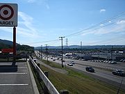
During the 1990s, Vestal became the major retail center of the Southern Tier region of New York, with many large shopping centers such as the Town Square Mall, Parkway Plaza, Shoppes at Vestal, and Campus Plaza being built along the Vestal Parkway (NY Route 434), which became one of the busiest roads in the area. Vestal's historic central business district is located along three blocks of Front Street, still lined with small shops.
The Drovers Inn and Round Family Residence
and Vestal Central School
were listed on the National Register of Historic Places
in 2010.
 According to the United States Census Bureau
, the town has a total area of 52.7 square miles (136.5 km²). 52.2 square miles (135.2 km²) of it is land and 0.5 square miles (1.3 km²) of it (0.95%) is water. The Town of Vestal is on the south side of the Susquehanna River
. The Susquehanna River flows westward past Vestal to towns like Owego and Waverly in Tioga County, NY. There, the river bends southward into Pennsylvania through Scranton/Wilkes Barre and its capital at Harrisburg, eventually flowing into the Chesapeake Bay at Havre de Grace, MD.
The north town line is defined by the Susquehanna River
, the west town line is the border of Tioga County
, and the south town line is the border of Susquehanna County
, Pennsylvania
.
New York State Route 17
passes across the north part of the town and intersect north-south highway New York State Route 26
by the Susquehanna River. New York State Route 434
, Vestal Parkway, intersects NY-26 south of the NY-17 junction. New York State Route 201
links the town to the north shore of the Susquehanna River.
of 2000, there were 26,535 people, 8,525 households, and 5,924 families residing in the town. In the 2010 census, the number becomes 28,043. The population density
was 508.5 /sqmi. There were 8,898 housing units at an average density of 170.5 per square mile (65.8/km²). The racial makeup of the town was 87.13% White, 2.19% African American, 0.15% Native American, 8.33% Asian, 0.99% from other races
, and 1.20% from two or more races. Hispanic or Latino of any race were 2.40% of the population.
There were 8,525 households out of which 29.6% had children under the age of 18 living with them, 59.9% were married couples
living together, 7.0% had a female householder with no husband present, and 30.5% were non-families. 25.1% of all households were made up of individuals and 10.7% had someone living alone who was 65 years of age or older. The average household size was 2.45 and the average family size was 2.95.
In the town the population was spread out with 18.9% under the age of 18, 24.0% from 18 to 24, 20.6% from 25 to 44, 20.8% from 45 to 64, and 15.8% who were 65 years of age or older. The median age was 34 years. For every 100 females there were 90.6 males. For every 100 females age 18 and over, there were 86.7 males.
The median income for a household in the town was $51,098, and the median income for a family was $60,676. Males had a median income of $48,731 versus $29,035 for females. The per capita income
for the town was $22,363. About 4.3% of families and 7.1% of the population were below the poverty line, including 7.6% of those under age 18 and 5.1% of those age 65 or over.
 Vestal is linked from the west primarily by New York State Route 17
, which is under development to become Interstate 86
. It is also very close to Interstate 81
and Interstate 88
. Two major bridges and one minor bridge of New York State Route 26
, New York State Route 201
, and Bridge Road link Vestal to the villages of Endicott
and Johnson City
. New York State Route 434
, "The Vestal Parkway" is the main artery through Vestal. It provides a direct link to Binghamton
in the east.
Broome County Transit
provides Vestal with bus service around the town and to surrounding municipalities. Greater Binghamton Airport
is located about seven miles (11 km) away in Maine
, New York
, and provides direct flights to Detroit Metropolitan Wayne County Airport
, Philadelphia International Airport
, and Washington Dulles International Airport
.
Vestal is also known for the heated auto-sales rivalry between the Millers and the Matthews.
The largest park in the area is Arnold Park located off of Pierce Hill Road. This park offers a newly constructed plastic playground, picnic areas, a sand volleyball court, a standard sized baseball field and three other large grassy areas, as well as a nature trail through the wooded areas surrounding the park. In October, the Recreation Department holds a Halloween event at the park. In August, the Recreation Department hosts a picnic and summer festival. The Recreational Baseball League hosts at this park a variety of competitions amongst leagues.
The Recreation Department operates the 40x20 yard Vestal Memorial Pool located on Clayton Avenue off of Rt. 434.
Vestal Rec. Dept. Pictures
Town
A town is a human settlement larger than a village but smaller than a city. The size a settlement must be in order to be called a "town" varies considerably in different parts of the world, so that, for example, many American "small towns" seem to British people to be no more than villages, while...
within Broome County
Broome County, New York
Broome County is a county located in the U.S. state of New York. As of the 2010 census, the population was 200,600. It was named in honor of John Broome, who was lieutenant governor in 1806 when Broome County was established. Its county seat is Binghamton, which is also its major city. The current...
in the Southern Tier
Southern Tier
The Southern Tier is a geographical term that refers to the counties of New York State west of the Catskill Mountains along the northern border of Pennsylvania. It is a loosely defined term that generally includes the counties that border Pennsylvania west of Delaware County inclusive...
of New York
New York
New York is a state in the Northeastern region of the United States. It is the nation's third most populous state. New York is bordered by New Jersey and Pennsylvania to the south, and by Connecticut, Massachusetts and Vermont to the east...
, and lies between the Susquehanna River
Susquehanna River
The Susquehanna River is a river located in the northeastern United States. At long, it is the longest river on the American east coast that drains into the Atlantic Ocean, and with its watershed it is the 16th largest river in the United States, and the longest river in the continental United...
and the Pennsylvania
Pennsylvania
The Commonwealth of Pennsylvania is a U.S. state that is located in the Northeastern and Mid-Atlantic regions of the United States. The state borders Delaware and Maryland to the south, West Virginia to the southwest, Ohio to the west, New York and Ontario, Canada, to the north, and New Jersey to...
border. As of the 2000 census, the population
Population
A population is all the organisms that both belong to the same group or species and live in the same geographical area. The area that is used to define a sexual population is such that inter-breeding is possible between any pair within the area and more probable than cross-breeding with individuals...
was 26,535, estimated to have grown to 27,369 in 2009.
Vestal is on the south border of the county and is west and southwest of Binghamton
Binghamton, New York
Binghamton is a city in the Southern Tier of New York in the United States. It is near the Pennsylvania border, in a bowl-shaped valley at the confluence of the Susquehanna and Chenango Rivers...
.
Vestal is home to Binghamton University
Binghamton University
Binghamton University, also formally called State University of New York at Binghamton, , is a public research university in the State of New York. The University is one of the four university centers in the State University of New York system...
which draws visitors to the town through its entertainment and sporting events. The university adds more than 14,000 students to the town and employs more than 3,000 faculty and staff.
History
The first European settlers arrived in Vestal at around 1785.The central area of Vestal, near Route 26 at Choconut Creek, was the site of an indigenous village of the Ochugnut tribe of the Tuscaroras. During the American Revolution
American Revolution
The American Revolution was the political upheaval during the last half of the 18th century in which thirteen colonies in North America joined together to break free from the British Empire, combining to become the United States of America...
, a squad of soldiers from the Sixth Massachusetts Regiment, under the command of Lt. William McKendry http://www.rootsweb.com/~usgenweb/pa/1pa/1picts/sullivan/roster.html were sent to exterminate the indigenous people. During the summer of 1779, the squad eliminated at least two villages, including one situated in what is now nearby downtown Binghamton (the Chenango, at the confluence of the Chenango
Chenango River
The Chenango River is a tributary of the Susquehanna River in central New York in the United States. It drains a dissected plateau area in upstate New York at the northern end of the Susquehanna watershed....
and Susquehanna
Susquehanna River
The Susquehanna River is a river located in the northeastern United States. At long, it is the longest river on the American east coast that drains into the Atlantic Ocean, and with its watershed it is the 16th largest river in the United States, and the longest river in the continental United...
rivers), and the Ochugnut (Choconut) at the site of Choconut Creek near present-day Vestal Senior High School
Vestal Senior High School
Vestal Senior High School is part of the Vestal Central School District which encompasses just west of Binghamton in the Southern Tier of New York. It is a four year comprehensive school which annually receives both national and state recognition for excellence in education...
.
Reasons for the attack include the Iroquois
Iroquois
The Iroquois , also known as the Haudenosaunee or the "People of the Longhouse", are an association of several tribes of indigenous people of North America...
alliance with Great Britain
Great Britain
Great Britain or Britain is an island situated to the northwest of Continental Europe. It is the ninth largest island in the world, and the largest European island, as well as the largest of the British Isles...
during the American Revolution. However, some evidence indicates that at least some of the indigenous people were actually Tuscarora
Tuscarora (tribe)
The Tuscarora are a Native American people of the Iroquoian-language family, with members in New York, Canada, and North Carolina...
- descendants of the Cherokee
Cherokee
The Cherokee are a Native American people historically settled in the Southeastern United States . Linguistically, they are part of the Iroquoian language family...
who fled from North Carolina after wars in 1711 and the War of 1763
French and Indian War
The French and Indian War is the common American name for the war between Great Britain and France in North America from 1754 to 1763. In 1756, the war erupted into the world-wide conflict known as the Seven Years' War and thus came to be regarded as the North American theater of that war...
. This community was actually sympathetic to the American cause, siding against the rest of the Iroquois confederation. See Sullivan Expedition
Sullivan Expedition
The Sullivan Expedition, also known as the Sullivan-Clinton Expedition, was an American campaign led by Major General John Sullivan and Brigadier General James Clinton against Loyalists and the four nations of the Iroquois who had sided with the British in the American Revolutionary War.The...
or external links for more information on the role of Upstate New York in this conflict. http://history.rays-place.com/ny/union-ny.htm http://www.stny.rr.com/choconut/history.htm
Following the war, several European families settled in the area near the Town of Union.
The Town of Vestal was formed from the southern half of the Town of Union
Union, New York
Union is a town in Broome County, New York. As of the 2000 census, the town had a total population of 56,298. The name derives from the town having served as a rendezvous for the Sullivan Expedition....
in 1823.
The history of the town is closely related to its neighbors, Binghamton
Binghamton, New York
Binghamton is a city in the Southern Tier of New York in the United States. It is near the Pennsylvania border, in a bowl-shaped valley at the confluence of the Susquehanna and Chenango Rivers...
, Endicott
Endicott, New York
Endicott is a village in Broome County, New York, United States. The population was 13,038 at the 2000 census. It is part of the Binghamton Metropolitan Statistical Area. The village is named after Henry B...
, and Johnson City
Johnson City, New York
Johnson City is a village in Broome County, New York, United States. The population was 15,535 at the 2000 census. It is part of the Binghamton Metropolitan Statistical Area....
. During the 20th century, Vestal served as a residential suburb to emerging industries in its area, such as Endicott Johnson Corporation
Endicott Johnson Corporation
The Endicott-Johnson Shoe Company was a prosperous manufacturer of shoes based in New York's Southern Tier, with factories mostly located in the area's Triple Cities of Binghamton, Johnson City, and Endicott...
, IBM
IBM
International Business Machines Corporation or IBM is an American multinational technology and consulting corporation headquartered in Armonk, New York, United States. IBM manufactures and sells computer hardware and software, and it offers infrastructure, hosting and consulting services in areas...
, and Lockheed Martin
Lockheed Martin
Lockheed Martin is an American global aerospace, defense, security, and advanced technology company with worldwide interests. It was formed by the merger of Lockheed Corporation with Martin Marietta in March 1995. It is headquartered in Bethesda, Maryland, in the Washington Metropolitan Area....
.
In 1950, Triple Cities College of Syracuse University, in Endicott
Endicott, New York
Endicott is a village in Broome County, New York, United States. The population was 13,038 at the 2000 census. It is part of the Binghamton Metropolitan Statistical Area. The village is named after Henry B...
, New York
New York
New York is a state in the Northeastern region of the United States. It is the nation's third most populous state. New York is bordered by New Jersey and Pennsylvania to the south, and by Connecticut, Massachusetts and Vermont to the east...
, relocated to Vestal and became Harpur College, a member of SUNY
State University of New York
The State University of New York, abbreviated SUNY , is a system of public institutions of higher education in New York, United States. It is the largest comprehensive system of universities, colleges, and community colleges in the United States, with a total enrollment of 465,000 students, plus...
. Today, the college has become Binghamton University
Binghamton University
Binghamton University, also formally called State University of New York at Binghamton, , is a public research university in the State of New York. The University is one of the four university centers in the State University of New York system...
, the highest ranked public university
Public university
A public university is a university that is predominantly funded by public means through a national or subnational government, as opposed to private universities. A national university may or may not be considered a public university, depending on regions...
in the Northeastern United States
Northeastern United States
The Northeastern United States is a region of the United States as defined by the United States Census Bureau.-Composition:The region comprises nine states: the New England states of Connecticut, Maine, Massachusetts, New Hampshire, Rhode Island and Vermont; and the Mid-Atlantic states of New...
. The University adds 14,000 students to the local population each school year, and draws large numbers into the town for sporting, arts and other events.
During the 1990s, Vestal became the major retail center of the Southern Tier region of New York, with many large shopping centers such as the Town Square Mall, Parkway Plaza, Shoppes at Vestal, and Campus Plaza being built along the Vestal Parkway (NY Route 434), which became one of the busiest roads in the area. Vestal's historic central business district is located along three blocks of Front Street, still lined with small shops.
The Drovers Inn and Round Family Residence
Drovers Inn and Round Family Residence
Drovers Inn and Round Family Residence consists of an historic home and an historic inn located at Vestal in Broome County, New York. The Drovers Inn was built about 1844 and the Rounds Family Residence was built 1895-1912. The inn is a -story wood-frame Greek Revival structure with an overlay of...
and Vestal Central School
Vestal Central School
Vestal Central School, also known as Central Junior High School, is a historic school building located at Vestal in Broome County, New York. It was built in 1939 and is a large three to four story, modified "U" shaped structure. It is built of variegated brick over cinder block with a steel...
were listed on the National Register of Historic Places
National Register of Historic Places
The National Register of Historic Places is the United States government's official list of districts, sites, buildings, structures, and objects deemed worthy of preservation...
in 2010.
Geography
United States Census Bureau
The United States Census Bureau is the government agency that is responsible for the United States Census. It also gathers other national demographic and economic data...
, the town has a total area of 52.7 square miles (136.5 km²). 52.2 square miles (135.2 km²) of it is land and 0.5 square miles (1.3 km²) of it (0.95%) is water. The Town of Vestal is on the south side of the Susquehanna River
Susquehanna River
The Susquehanna River is a river located in the northeastern United States. At long, it is the longest river on the American east coast that drains into the Atlantic Ocean, and with its watershed it is the 16th largest river in the United States, and the longest river in the continental United...
. The Susquehanna River flows westward past Vestal to towns like Owego and Waverly in Tioga County, NY. There, the river bends southward into Pennsylvania through Scranton/Wilkes Barre and its capital at Harrisburg, eventually flowing into the Chesapeake Bay at Havre de Grace, MD.
The north town line is defined by the Susquehanna River
Susquehanna River
The Susquehanna River is a river located in the northeastern United States. At long, it is the longest river on the American east coast that drains into the Atlantic Ocean, and with its watershed it is the 16th largest river in the United States, and the longest river in the continental United...
, the west town line is the border of Tioga County
Tioga County, New York
As of the census of 2010, there were 51,125 people residing in the county, with 22,203 housing units, of these 20,350 occupied, 1,853 vacant. The population density was 98 people per square mile...
, and the south town line is the border of Susquehanna County
Susquehanna County, Pennsylvania
-Demographics:As of the census of 2000, there were 42,238 people, 16,529 households, and 11,785 families residing in the county. The population density was 51 people per square mile . There were 21,829 housing units at an average density of 26 per square mile...
, Pennsylvania
Pennsylvania
The Commonwealth of Pennsylvania is a U.S. state that is located in the Northeastern and Mid-Atlantic regions of the United States. The state borders Delaware and Maryland to the south, West Virginia to the southwest, Ohio to the west, New York and Ontario, Canada, to the north, and New Jersey to...
.
New York State Route 17
New York State Route 17
New York State Route 17 is a state highway that extends for through the Southern Tier and Downstate regions of New York in the United States...
passes across the north part of the town and intersect north-south highway New York State Route 26
New York State Route 26
New York State Route 26 is a north–south state highway that runs for through Central New York in the United States. Its southern terminus is located at the Pennsylvania state line south of the town of Vestal in Broome County, where it becomes Pennsylvania Route 267...
by the Susquehanna River. New York State Route 434
New York State Route 434
New York State Route 434 is a state highway located in the Southern Tier of the U.S. state of New York. The route extends for from an intersection with NY 96 in the village of Owego to an intersection with US 11 in the city of Binghamton. In between, NY 434 passes through the...
, Vestal Parkway, intersects NY-26 south of the NY-17 junction. New York State Route 201
New York State Route 201
New York State Route 201 is a north–south state highway located west of the city of Binghamton in Broome County, New York...
links the town to the north shore of the Susquehanna River.
Demographics
As of the censusCensus
A census is the procedure of systematically acquiring and recording information about the members of a given population. It is a regularly occurring and official count of a particular population. The term is used mostly in connection with national population and housing censuses; other common...
of 2000, there were 26,535 people, 8,525 households, and 5,924 families residing in the town. In the 2010 census, the number becomes 28,043. The population density
Population density
Population density is a measurement of population per unit area or unit volume. It is frequently applied to living organisms, and particularly to humans...
was 508.5 /sqmi. There were 8,898 housing units at an average density of 170.5 per square mile (65.8/km²). The racial makeup of the town was 87.13% White, 2.19% African American, 0.15% Native American, 8.33% Asian, 0.99% from other races
Race (United States Census)
Race and ethnicity in the United States Census, as defined by the Federal Office of Management and Budget and the United States Census Bureau, are self-identification data items in which residents choose the race or races with which they most closely identify, and indicate whether or not they are...
, and 1.20% from two or more races. Hispanic or Latino of any race were 2.40% of the population.
There were 8,525 households out of which 29.6% had children under the age of 18 living with them, 59.9% were married couples
Marriage
Marriage is a social union or legal contract between people that creates kinship. It is an institution in which interpersonal relationships, usually intimate and sexual, are acknowledged in a variety of ways, depending on the culture or subculture in which it is found...
living together, 7.0% had a female householder with no husband present, and 30.5% were non-families. 25.1% of all households were made up of individuals and 10.7% had someone living alone who was 65 years of age or older. The average household size was 2.45 and the average family size was 2.95.
In the town the population was spread out with 18.9% under the age of 18, 24.0% from 18 to 24, 20.6% from 25 to 44, 20.8% from 45 to 64, and 15.8% who were 65 years of age or older. The median age was 34 years. For every 100 females there were 90.6 males. For every 100 females age 18 and over, there were 86.7 males.
The median income for a household in the town was $51,098, and the median income for a family was $60,676. Males had a median income of $48,731 versus $29,035 for females. The per capita income
Per capita income
Per capita income or income per person is a measure of mean income within an economic aggregate, such as a country or city. It is calculated by taking a measure of all sources of income in the aggregate and dividing it by the total population...
for the town was $22,363. About 4.3% of families and 7.1% of the population were below the poverty line, including 7.6% of those under age 18 and 5.1% of those age 65 or over.
Transportation
New York State Route 17
New York State Route 17 is a state highway that extends for through the Southern Tier and Downstate regions of New York in the United States...
, which is under development to become Interstate 86
Interstate 86 (east)
Interstate 86 is an Interstate Highway that extends for through northwestern Pennsylvania and southern New York in the United States...
. It is also very close to Interstate 81
Interstate 81
Interstate 81 is an Interstate Highway in the eastern part of the United States. Its southern terminus is at Interstate 40 in Dandridge, Tennessee; its northern terminus is on Wellesley Island at the Canadian border, where the Thousand Islands Bridge connects it to Highway 401, the main freeway...
and Interstate 88
Interstate 88 (east)
Interstate 88 is an intrastate Interstate Highway entirely within the U.S. state of New York. Its western end is at Interstate 81 in Binghamton and its eastern end is at Interstate 90 in Schenectady. It serves as an important connector route from Albany to Binghamton, Elmira , and...
. Two major bridges and one minor bridge of New York State Route 26
New York State Route 26
New York State Route 26 is a north–south state highway that runs for through Central New York in the United States. Its southern terminus is located at the Pennsylvania state line south of the town of Vestal in Broome County, where it becomes Pennsylvania Route 267...
, New York State Route 201
New York State Route 201
New York State Route 201 is a north–south state highway located west of the city of Binghamton in Broome County, New York...
, and Bridge Road link Vestal to the villages of Endicott
Endicott, New York
Endicott is a village in Broome County, New York, United States. The population was 13,038 at the 2000 census. It is part of the Binghamton Metropolitan Statistical Area. The village is named after Henry B...
and Johnson City
Johnson City, New York
Johnson City is a village in Broome County, New York, United States. The population was 15,535 at the 2000 census. It is part of the Binghamton Metropolitan Statistical Area....
. New York State Route 434
New York State Route 434
New York State Route 434 is a state highway located in the Southern Tier of the U.S. state of New York. The route extends for from an intersection with NY 96 in the village of Owego to an intersection with US 11 in the city of Binghamton. In between, NY 434 passes through the...
, "The Vestal Parkway" is the main artery through Vestal. It provides a direct link to Binghamton
Binghamton, New York
Binghamton is a city in the Southern Tier of New York in the United States. It is near the Pennsylvania border, in a bowl-shaped valley at the confluence of the Susquehanna and Chenango Rivers...
in the east.
Broome County Transit
Broome County Transit
Broome County Transit, popularly branded as B.C. Transit, is the public transportation system serving Broome County, New York, which includes the city of Binghamton and surrounding communities....
provides Vestal with bus service around the town and to surrounding municipalities. Greater Binghamton Airport
Greater Binghamton Airport
Greater Binghamton Airport is a medium-sized regional airport located in Maine, New York that serves the Southern Tier of New York, primarily Broome and Tioga counties....
is located about seven miles (11 km) away in Maine
Maine, New York
Maine is a town in Broome County, New York, United States. The population was 5,459 at the 2000 census.The Town of Maine is on the western border of the county and is northwest of Binghamton.Maine is home to the Greater Binghamton Airport...
, New York
New York
New York is a state in the Northeastern region of the United States. It is the nation's third most populous state. New York is bordered by New Jersey and Pennsylvania to the south, and by Connecticut, Massachusetts and Vermont to the east...
, and provides direct flights to Detroit Metropolitan Wayne County Airport
Detroit Metropolitan Wayne County Airport
Detroit Metropolitan Wayne County Airport , usually called Detroit Metro Airport, Metro Airport locally, or simply DTW, is a major international airport covering in Romulus, Michigan, a suburb of Detroit. It is Michigan's busiest airport....
, Philadelphia International Airport
Philadelphia International Airport
Philadelphia International Airport is a major airport in Philadelphia, Pennsylvania, United States, and is the largest airport in the Delaware Valley region and in Pennsylvania...
, and Washington Dulles International Airport
Washington Dulles International Airport
Washington Dulles International Airport is a public airport in Dulles, Virginia, 26 miles west of downtown Washington, D.C. The airport serves the Baltimore-Washington-Northern Virginia metropolitan area centered on the District of Columbia. It is named after John Foster Dulles, Secretary of...
.
Vestal is also known for the heated auto-sales rivalry between the Millers and the Matthews.
Schools
- Binghamton UniversityBinghamton UniversityBinghamton University, also formally called State University of New York at Binghamton, , is a public research university in the State of New York. The University is one of the four university centers in the State University of New York system...
- A SUNYState University of New YorkThe State University of New York, abbreviated SUNY , is a system of public institutions of higher education in New York, United States. It is the largest comprehensive system of universities, colleges, and community colleges in the United States, with a total enrollment of 465,000 students, plus...
university center with over 14,000 students. - Vestal Central School DistrictVestal Central School DistrictVestal Central School District is a school district in Vestal, New York. It covers about west of Binghamton, New York, serving a portion of Apalachin, New York in addition to Vestal, New York...
- A school district which includes Vestal High School, ranked in the top 1000 high schools in the United States according to Newsweek. http://www.msnbc.msn.com/id/8759025/site/newsweek/?page=6 - Hillel Academy http://www.hillelacademybc.org/
- Ross Corners Christian AcademyRoss Corners Christian AcademyRoss Corners Christian Academy is a private school located in Vestal, New York associated with Ross Corners Baptist Church.. It holds grades Preschool through 12th. It is open for all students...
http://www.RCCArams.org/
Shopping/Dining/Entertainment in Vestal
- Town Square Mall
- The Shoppes at Vestal
- Parkway Plaza
- Campus Plaza
- University Plaza (UP)
- Parkway Row
Recreational Areas in Vestal
The town of Vestal has 21 town operated and maintained parks which cater to all ages.- Arnold Park – Andrews Road
Four picnic shelters (shelter #1 is under construction), tables, grills, playground equipment, playing fields with lights, football field, softball fields, rest room facilities, running water, electricity, nature trail, hiking, sand volleyball court, ice skating, fitness trail, cross country skiing, parking.
- African Road Park – African Road
Picnic shelter, grill, playground equipment, running water,
stream, playground, electric, parking.
- Barlow Park – Main Street
Picnic shelter, tables, grill, playground equipment, running water, parking, electricity.
- Castle Gardens Park – Garden Lane
Picnic shelter, tables, grill, playground equipment, ball field, half basketball court, running water, no parking.
- David Avenue Park – David Avenue
Picnic shelter, tables, grill, playground equipment, tennis court, basketball court, stream.
- DEC Flood Fields – Main Street
Soccer fields, ball field, golf practice.
- Ethel Place Park – Ethel Park
Picnic shelter, tables, grill, playground equipment, basketball and kickball court, running water, no parking.
- Fuller Hollow Park – Marietta Drive
Picnic shelter, tables, playground equipment, ball field, stream, no parking.
- Harold Moore Park – Old Vestal Road
Picnic shelter, tables, grill, playground equipment, softball fields, two full court basketball courts, rest rooms and concession stand, running water, soccer fields, electricity, river access, boat ramp, parking.
- Jones Park – State Line Road
Nature trail, stream, hiking, cross country skiing, parking. Dogs allowed on leash.
- Memorial Park – Four Corners - Rt. 434 & Front Street
Band Gazebo, electricity, park benches, and free summer band concerts on Tuesdays at 7:00 PM. No parking.
- Middendorf Park – Juneberry Road
Picnic shelter, tables, grill, playground equipment, ball field, basketball court, running water, parking.
- Richards Avenue Park – Richards Avenue
Picnic shelter, tables, grill, playground equipment, no parking, running water.
- Ross Corners Park – Old Owego Road
Picnic shelter, tables, grill, playground equipment, tennis courts, ball field, soccer field, running water, parking, ice skating.
- Stair Park – Murray Hill Road
Picnic shelter, tables, playground equipment, running water, parking, electric.
- Stratford Park – Stratford Drive
Picnic shelter, tables, playground, running water, no parking.
- Twin Orchards – Myrtle Street
Picnic shelter, tables, playground, ball field, running water, soccer field and parking.
- Vestal Center Park – Coleman Street
Picnic shelter, playground equipment, tennis courts, ball field, basketball court, running water, ice-skating, parking.
- Vestal Memorial Pool – Clayton Avenue
Large outdoor pool & wading pool, rest rooms & changing area, electricity, running water, parking.
- Willow Point Park – Gates Road
Three softball fields.
- Vestal Rail Trail
The trail is 2.1 miles (3.4 km) long. It runs between North Main Street and African Road and is located just north of and parallel to the Vestal Parkway (Rt. 434). The trail has a twelve foot paved path and eight feet of grass on either side of the trail. Parking at Stage Rd. and on the east side of the Shoppes at Vestal. No restrooms. The trail has benches and dog waste facilities.
The largest park in the area is Arnold Park located off of Pierce Hill Road. This park offers a newly constructed plastic playground, picnic areas, a sand volleyball court, a standard sized baseball field and three other large grassy areas, as well as a nature trail through the wooded areas surrounding the park. In October, the Recreation Department holds a Halloween event at the park. In August, the Recreation Department hosts a picnic and summer festival. The Recreational Baseball League hosts at this park a variety of competitions amongst leagues.
The Recreation Department operates the 40x20 yard Vestal Memorial Pool located on Clayton Avenue off of Rt. 434.
Vestal Rec. Dept. Pictures
Hamlets
The Town of Vestal recognizes five hamlets within its borders:- Ross Corners is named for David Ross, a prominent Lumberman who owned a store during much of the 19th Century in the west of the town.
- Tracy Creek is named for Benjamin Tracy and is situated by a creek of the same name. It was originally a lumbering and farming community. It is also located in the western section of the town.
- Twin Orchards is a hamlet on the south bank of the Susquehanna RiverSusquehanna RiverThe Susquehanna River is a river located in the northeastern United States. At long, it is the longest river on the American east coast that drains into the Atlantic Ocean, and with its watershed it is the 16th largest river in the United States, and the longest river in the continental United...
, named for the large orchards that used to border both sides of its main road. - Vestal Center is located on NY-26 at the intersection of County Road 53, on the Big Choconut Creek about four miles (6 km) south of the main district, and approximately three miles north of the Pennsylvania State Line. It was originally spelled in English fashion ("Vestal Centre"), but this was changed in 1893. President Theodore RooseveltTheodore RooseveltTheodore "Teddy" Roosevelt was the 26th President of the United States . He is noted for his exuberant personality, range of interests and achievements, and his leadership of the Progressive Movement, as well as his "cowboy" persona and robust masculinity...
once visited and gave a speech. - Willow Point is located east of Twin Orchards, also on the south bank of the Susquehanna River.
Other locations
- Castle Gardens – On the shore of the Susquehanna River in the western section of the town. Frequently flooded.
- Four Corners – The town's center; refers to the intersection of Main St. and the Vestal Parkway.
- South Vestal – A hamlet in the southern part of the town on Route 26.
- Stair Tract – Two developments (Upper and Lower) on the Eastern edge of the town.
- Vestal Hills – A hamlet in the northeastern part of town, adjacent to Binghamton.