
Uthai Thani Province
Encyclopedia
Uthai Thani is one of the provinces
(changwat) of Thailand
. Neighboring provinces are (from north clockwise) Nakhon Sawan
, Chai Nat
, Suphan Buri
, Kanchanaburi
and Tak
.
, a tributary of the Chao Phraya River
is the main river of Uthai Thani province.
The Huai Kha Khaeng Wildlife Sanctuary
at the western boundary to the province Tak and was declared World Heritage in 1991. It covers 2,574 km², and houses almost all of the forest animals of South-East Asia, including tiger
s and elephant
s.
settled in the area. A first Thai settlement in the area was Muang U Thai during the Sukhothai period
, but was later abandoned when the river changed course. Patabeut, a member of the Karen ethnicity, revived the settlement at its currect place during the Ayutthaya period. It served as a fort protecting the boundary of the kingdom then.
Uthai Thani is most famous as being the hometown of the father of King Rama I. Rama I also renamed the city from its old name Uthai to Uthai Thani.
In 1892 King Chulalongkorn
(Rama V) added the area of Uthai Thani to the Monthon
Nakhon Sawan, and in 1898 formed the province.
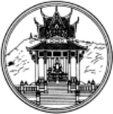
depicts the pavilion at Wat Khao Sakaekrang. It houses the statue of Thongdee, the father of King Rama I. The mountain in the background symbolizes the location of the pavilion on top of a hill.
Provincial flower is the Yellow Cotton Tree (Cochlospermum regium), provincial tree is Neem
(Azadirachta indica v. siamensis).
The flag of Uthai Thani depicts the provincial seal of Uthai Thani in the middle. The yellow color in the top of the flag is the symbol color of the Chakri dynasty, as Gold
as a precious metal is a symbol for the Thai monarchy. The green color in bottom is the symbol color of King Rama I as he was born on a Wednesday, which is associated with green in the Thai calendar
. The text below the seal says Uthai Thani province.
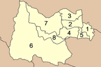 The province is subdivided in 8 districts (amphoe
). These are further subdivided into 70 subdistricts (tambon
) and 642 villages (muban
).
period. In addition, in one corner of the temple is a pavilion housing a statue of the father of King Rama I.
Wat Ubosatharam (วัดอุโบสถาราม): Many historical sites and artefacts are found inside. Also of interest are the octagonal multi-tiered roof, the Bot Nam raft, the replica of Lord Buddha’s footprint from the time of King Rama IV, a silver Buddha image and gifts from King Rama V to Luang Pho Chan Wat Bot.
Bot Nam (โบสถ์น้ำ): It was built to receive King Rama V when he visited northern provinces in 1906. Originally a twin raft, it has an elongated carved apex of the gable like normal temple main halls. Today the raft is used by raft residents for religious ceremonies.
Rafts on Sakae Krang River (เรือนแพลำน้ำสะแกกรัง) reflect the lifestyle of Uthai Thani people that has always been linked with water. Water is used here to grow pandanus
and for raising fish in floating baskets, particularly gourami
. This has become the main occupation of the province and has made it famous.
Wat Chantharam or Wat Tha Sung (วัดจันทารามหรือวัดท่าซุง): It is an old temple from the Ayutthaya
period. The item of note in this temple is a pulpit
built by Luang Pho Yai. More buildings were later added by the monk Phra Ratchaphrom Yan Nen (Luang Pho Rusi Ling Dam).
Local History and Cultural Museum (ศูนย์วิทยาศาสตร์เทคโนโลยีและสิ่งแวดล้อม): On display are prehistoric human skeletons, clothes, regalia of city lords and a room with wooden models of Thai houses.
Wat Thammakhosok (วัดธรรมโฆษก): This temple was used for holding rites by Uthai Thani government officials where they pledge allegiance to the king. It was also in service as an execution site. The most interesting edifices are the chapel and the main Buddha image hall.
Wat Thap Than (วัดทัพทัน): The items of interest here is the lovely carved door depicting an angel holding an arrow standing on a serpent and another of an angel tending deer holding a pike on a lion.
Thalaad Kwai Thap Than is a lively market for water buffalo
es. It is a great opportunity to study these huge mammals in large quantities.
Ban Khok Mo Weaving Village (แหล่งทอผ้าพื้นเมืองบ้านโคกหม้อ) is a small village of Thai-Lao residents whose ancestors migrated here in the Rattanakosin
period. Villagers take to weaving when the harvest ends. Their products are made from Sin Tin Chok Silk, Mat Mi silk and traditional-style fabrics with floral patterns.
Bung Khok Chang Ancient City (เมืองโบราณบึงคอกช้าง) was a town surrounded by a moat and an earthen wall. A sacred pond is at the outer corner of each wall. Artefacts unearthed here include tools, utensils and a stone scripture in the Mon
language.
Prehistoric colour drawings at Khao Pla Ra (ภาพเขียนสีก่อนประวัติศาสตร์เขาปลาร้า): These coloured cave drawings stretch for around 9 metres. The prehistoric and detailed drawings are of humans and animals in red and black. They are certainly invaluable as part of the artistic heritage of the country.
Tham Hup Pa Tat (ถ้ำหุบป่าตาด): The mountain range surrounding the valley is a limestone range. The way up to this cave is through a margosa forest. The valley has a higher humidity than it surrounds, contributing to the abundant flora.
Tham Khao Khong Chai (ถ้ำเขาฆ้องชัย) is a cave on a limestone
mountain range, which is renowned for its natural beauty, with an elevation of about 353 metres. The first cave is large and stone tools and earthenware pieces were discovered here.
Khao Phraya Phai Rua (เขาพระยาพายเรือ): The mountain is shaped like a Chinese junk and is surrounded by a natural moat. It is covered with many species of plants and there are altogether 12 caves leading underground.
Huai Kha Khaeng Wildlife Sanctuary
(เขตรักษาพันธุ์สัตว์ป่าห้วยขาแข้ง) consists of almost every kind of forest found in Thailand. The unspoiled nature of the reserve makes it an ideal home to various rare and endangered animals. Due to these attributes, Huai Kha Khaeng Wildlife Reserve was named by UNESCO as a Natural World Heritage Site.
Ban Samo Thong Hot Spring (น้ำพุร้อนบ้านสมอทอง): This is a small spring with clear water, pungent with the aroma of sulphur. The spring has an area of 4,000 square metres and consists of 3 separate springs.
Namtok Cyber (น้ำตกไซเบอร์): The waterfall is situated amidst nature surrounded by the Huai Kha Khaeng forest. The water comes from the western mountain of the nature reserve, resulting in a medium-sized waterfall that drops down several levels before splashing on the boulders below.
Wat Khao Wong
(วัดเขาวงพรหมจรรย์) is a temple in a valley. It has a beautiful two-storey Thai-style convocation hall. The monastery is the 13th of 19 branches of Wat Sangkhathan in Nonthaburi. Other branches can be found in places such as Chiang Mai
, Um Phang, the United Kingdom
and India
.
Lan Sak Amphoe: Very old teak
trees line this picturesque town's access roads. The town is famous for solid furniture made from this precious wood.
Namtok Pha Rom Yen (น้ำตกผาร่มเย็น): The highlight of this waterfall lies its uniqueness of being a limestone waterfall that falls from a cliff. It can be clearly seen from the road nearby. This beautiful waterfall flows from a small stream 4 levels up.
Ban I Mat-I Sai Hill Tribe Cultural Centre is in Tambon Kaen Makrut. The centre has a house with a raised lower floor, a thatched roof and bamboo walls.
is also widely grown on Ko Thepho.
Local woven materials (ผ้าทอพื้นเมือง)
Products made from bamboo and water hyacinth (เครื่องจักสานจากไม้ไผ่และผักตบชวา)
Provinces of Thailand
Thailand is divided into 76 provinces , which are geographically grouped into 6 regions. The capital Bangkok is not a province but a special administrative area and is included as the 77th province since it is administered at the same level as the other 76 provinces. The name of the provinces are...
(changwat) of Thailand
Thailand
Thailand , officially the Kingdom of Thailand , formerly known as Siam , is a country located at the centre of the Indochina peninsula and Southeast Asia. It is bordered to the north by Burma and Laos, to the east by Laos and Cambodia, to the south by the Gulf of Thailand and Malaysia, and to the...
. Neighboring provinces are (from north clockwise) Nakhon Sawan
Nakhon Sawan Province
Nakhon Sawan is one of the provinces of Thailand. Neighboring provinces are Kamphaeng Phet, Phichit, Phetchabun, Lop Buri, Sing Buri, Chai Nat, Uthai Thani and Tak.- Etymology :...
, Chai Nat
Chainat Province
Chainat is one of the central provinces of Thailand. Neighboring provinces are Nakhon Sawan, Sing Buri, Suphan Buri and Uthai Thani.-Geography:...
, Suphan Buri
Suphanburi Province
Suphan Buri is one of the central provinces of Thailand. Neighboring provinces are Uthai Thani, Chai Nat, Sing Buri, Ang Thong, Phra Nakhon Si Ayutthaya, Nakhon Pathom and Kanchanaburi.- Etymology :...
, Kanchanaburi
Kanchanaburi Province
- History :Archaeology found in Kanchanaburi dates back to the 4th century which proves of trade with surrounding countries even in that time. Very little is also historically known about the actual Khmer influence in Kanchanaburi but there is evidence of their occupation with Prasat Muang Singh –...
and Tak
Tak Province
Tak is one of the northern provinces of Thailand. Neighboring provinces are Mae Hong Son, Chiang Mai, Lamphun, Lampang, Sukhothai, Kamphaeng Phet, Nakhon Sawan, Uthai Thani and Kanchanaburi...
.
Geography
The province stretches from the upper plains of the Chao Phraya river valley, to mountains covered with forests in the west. The Sakae Krang RiverSakae Krang River
The Sakae Krang River is a tributary of the Chao Phraya River. It originates in Mae Wong National Park, Kamphaeng Phet Province. It is 225 km long, with most of its length in Uthai Thani Province...
, a tributary of the Chao Phraya River
Chao Phraya River
The Chao Phraya is a major river in Thailand, with its low alluvial plain forming the centre of the country. It runs through Bangkok, the capital city, and then empties into the Gulf of Thailand.-Etymology:...
is the main river of Uthai Thani province.
The Huai Kha Khaeng Wildlife Sanctuary
Huai Kha Khaeng Wildlife Sanctuary
Huai Kha Khaeng Wildlife Sanctuary is a protected area in Thailand. It is located in the Provinces Kanchanaburi, Tak and Uthai Thani. It was declared a World Heritage Site Site by the United Nations in 1991, together with the adjoining Thungyai Naresuan Wildlife Sanctuary...
at the western boundary to the province Tak and was declared World Heritage in 1991. It covers 2,574 km², and houses almost all of the forest animals of South-East Asia, including tiger
Tiger
The tiger is the largest cat species, reaching a total body length of up to and weighing up to . Their most recognizable feature is a pattern of dark vertical stripes on reddish-orange fur with lighter underparts...
s and elephant
Elephant
Elephants are large land mammals in two extant genera of the family Elephantidae: Elephas and Loxodonta, with the third genus Mammuthus extinct...
s.
History
Originally Mon and LawaLawa people
Lawa are an ethnic group in Laos and northern Thailand. They lived there before Thai people arrived. Today they live often in their traditional way of life, often professing animism. As the other mountain ethnic groups of Thailand, they are known for extraordinary craft skills...
settled in the area. A first Thai settlement in the area was Muang U Thai during the Sukhothai period
Sukhothai kingdom
The Sukhothai Kingdom ) was an early kingdom in the area around the city Sukhothai, in north central Thailand. The Kingdom existed from 1238 till 1438...
, but was later abandoned when the river changed course. Patabeut, a member of the Karen ethnicity, revived the settlement at its currect place during the Ayutthaya period. It served as a fort protecting the boundary of the kingdom then.
Uthai Thani is most famous as being the hometown of the father of King Rama I. Rama I also renamed the city from its old name Uthai to Uthai Thani.
In 1892 King Chulalongkorn
Chulalongkorn
Phra Bat Somdet Phra Poramintharamaha Chulalongkorn Phra Chunla Chom Klao Chao Yu Hua , or Rama V was the fifth monarch of Siam under the House of Chakri. He was known to the Siamese of his time as Phra Phuttha Chao Luang . He is considered one of the greatest kings of Siam...
(Rama V) added the area of Uthai Thani to the Monthon
Monthon
A monthon |]], literally "circle") was a country subdivision of Thailand in the beginning of the 20th century. The Thai word 'monthon' is a translation of the word Mandala. These were created as a part of the thesaphiban bureaucratic administrative system, introduced by Prince Damrong Rajanubhab...
Nakhon Sawan, and in 1898 formed the province.
Symbols
The provincial sealSeals of The Provinces of Thailand
-Present-day provinces of Thailand:This list includes all the seals of the Provinces of Thailand. It also includes the special administrative area of the capital, Bangkok.-Former Provinces:-External links:*...
depicts the pavilion at Wat Khao Sakaekrang. It houses the statue of Thongdee, the father of King Rama I. The mountain in the background symbolizes the location of the pavilion on top of a hill.
Provincial flower is the Yellow Cotton Tree (Cochlospermum regium), provincial tree is Neem
Neem
Azadirachta indica is a tree in the mahogany family Meliaceae. It is one of two species in the genus Azadirachta, and is native to India growing in tropical and semi-tropical regions. Its fruits and seeds are the source of neem oil...
(Azadirachta indica v. siamensis).
The flag of Uthai Thani depicts the provincial seal of Uthai Thani in the middle. The yellow color in the top of the flag is the symbol color of the Chakri dynasty, as Gold
Gold
Gold is a chemical element with the symbol Au and an atomic number of 79. Gold is a dense, soft, shiny, malleable and ductile metal. Pure gold has a bright yellow color and luster traditionally considered attractive, which it maintains without oxidizing in air or water. Chemically, gold is a...
as a precious metal is a symbol for the Thai monarchy. The green color in bottom is the symbol color of King Rama I as he was born on a Wednesday, which is associated with green in the Thai calendar
Thai solar calendar
The Thai solar calendar, Suriyakati was adopted by King Chulalongkorn in AD 1888 as the Siamese version of the Gregorian calendar. It is the legal calendar in Thailand, though Thai lunar calendar dates continue in use. Years are now counted in the Buddhist Era that is 543 years greater than...
. The text below the seal says Uthai Thani province.
Administrative divisions
Amphoe
An amphoe is the second level administrative subdivision of Thailand. Usually translated as district, amphoe make up the provinces, and are analogous to a county seat...
). These are further subdivided into 70 subdistricts (tambon
Tambon
Tambon is a local government unit in Thailand. Below district and province , they form the third administrative subdivision level. As of the 2009 there are 7255 tambon, not including the 169 khwaeng of Bangkok, which are set at the same administrative level, thus every district contains 8-10 tambon...
) and 642 villages (muban
Muban
Muban is the lowest administrative subdivision of Thailand. Usually translated as village, they are the subdivision of tambon. As of 2008, there are 74944 administrative villages in Thailand. As of the 1990 census, the average village consisted of 144 households or 746 persons.A muban does not...
).
|
|
Sights
Wat Sankat Rattana Khiri (วัดสังกัสรัตนคีรี): Inside the main hall is "Phra Phuttha Mongkhon Sai Sit" or "Luang Pho Mongkhon", an ancient bronze Buddha image form the SukhothaiSukhothai kingdom
The Sukhothai Kingdom ) was an early kingdom in the area around the city Sukhothai, in north central Thailand. The Kingdom existed from 1238 till 1438...
period. In addition, in one corner of the temple is a pavilion housing a statue of the father of King Rama I.
Wat Ubosatharam (วัดอุโบสถาราม): Many historical sites and artefacts are found inside. Also of interest are the octagonal multi-tiered roof, the Bot Nam raft, the replica of Lord Buddha’s footprint from the time of King Rama IV, a silver Buddha image and gifts from King Rama V to Luang Pho Chan Wat Bot.
Bot Nam (โบสถ์น้ำ): It was built to receive King Rama V when he visited northern provinces in 1906. Originally a twin raft, it has an elongated carved apex of the gable like normal temple main halls. Today the raft is used by raft residents for religious ceremonies.
Rafts on Sakae Krang River (เรือนแพลำน้ำสะแกกรัง) reflect the lifestyle of Uthai Thani people that has always been linked with water. Water is used here to grow pandanus
Pandanus
Pandanus is a genus of monocots with about 600 known species. They are numerous palmlike dioecious trees and shrubs native of the Old World tropics and subtropics. They are classified in the order Pandanales, family Pandanaceae.-Overview:...
and for raising fish in floating baskets, particularly gourami
Gourami
Gouramis are a family, Osphronemidae, of freshwater perciform fishes. The fish are native to Asia, from Pakistan and India to the Malay Archipelago and north-easterly towards Korea. The name "gourami" is also used for fish of the families Helostomatidae and Anabantidae. "Gouramis" is an example of...
. This has become the main occupation of the province and has made it famous.
Wat Chantharam or Wat Tha Sung (วัดจันทารามหรือวัดท่าซุง): It is an old temple from the Ayutthaya
Ayutthaya kingdom
Ayutthaya was a Siamese kingdom that existed from 1350 to 1767. Ayutthaya was friendly towards foreign traders, including the Chinese, Vietnamese , Indians, Japanese and Persians, and later the Portuguese, Spanish, Dutch and French, permitting them to set up villages outside the walls of the...
period. The item of note in this temple is a pulpit
Pulpit
Pulpit is a speakers' stand in a church. In many Christian churches, there are two speakers' stands at the front of the church. Typically, the one on the left is called the pulpit...
built by Luang Pho Yai. More buildings were later added by the monk Phra Ratchaphrom Yan Nen (Luang Pho Rusi Ling Dam).
Local History and Cultural Museum (ศูนย์วิทยาศาสตร์เทคโนโลยีและสิ่งแวดล้อม): On display are prehistoric human skeletons, clothes, regalia of city lords and a room with wooden models of Thai houses.
Wat Thammakhosok (วัดธรรมโฆษก): This temple was used for holding rites by Uthai Thani government officials where they pledge allegiance to the king. It was also in service as an execution site. The most interesting edifices are the chapel and the main Buddha image hall.
Wat Thap Than (วัดทัพทัน): The items of interest here is the lovely carved door depicting an angel holding an arrow standing on a serpent and another of an angel tending deer holding a pike on a lion.
Thalaad Kwai Thap Than is a lively market for water buffalo
Water buffalo
The water buffalo is a domesticated bovid widely kept in Asia, Europe and South America.Water buffalo can also refer to:*Wild water buffalo , the wild ancestor of the domestic water buffalo...
es. It is a great opportunity to study these huge mammals in large quantities.
Ban Khok Mo Weaving Village (แหล่งทอผ้าพื้นเมืองบ้านโคกหม้อ) is a small village of Thai-Lao residents whose ancestors migrated here in the Rattanakosin
Rattanakosin
Rattanakosin may refer to*Rattanakosin Island, the historic center of Bangkokestablishment of Bangkok as capital, and continuing to the present day*Rattanakosin style , a distinct period in the Thai art...
period. Villagers take to weaving when the harvest ends. Their products are made from Sin Tin Chok Silk, Mat Mi silk and traditional-style fabrics with floral patterns.
Bung Khok Chang Ancient City (เมืองโบราณบึงคอกช้าง) was a town surrounded by a moat and an earthen wall. A sacred pond is at the outer corner of each wall. Artefacts unearthed here include tools, utensils and a stone scripture in the Mon
Mon people
The Mon are an ethnic group from Burma , living mostly in Mon State, Bago Division, the Irrawaddy Delta, and along the southern Thai–Burmese border. One of the earliest peoples to reside in Southeast Asia, the Mon were responsible for the spread of Theravada Buddhism in Burma and Thailand...
language.
Prehistoric colour drawings at Khao Pla Ra (ภาพเขียนสีก่อนประวัติศาสตร์เขาปลาร้า): These coloured cave drawings stretch for around 9 metres. The prehistoric and detailed drawings are of humans and animals in red and black. They are certainly invaluable as part of the artistic heritage of the country.
Tham Hup Pa Tat (ถ้ำหุบป่าตาด): The mountain range surrounding the valley is a limestone range. The way up to this cave is through a margosa forest. The valley has a higher humidity than it surrounds, contributing to the abundant flora.
Tham Khao Khong Chai (ถ้ำเขาฆ้องชัย) is a cave on a limestone
Limestone
Limestone is a sedimentary rock composed largely of the minerals calcite and aragonite, which are different crystal forms of calcium carbonate . Many limestones are composed from skeletal fragments of marine organisms such as coral or foraminifera....
mountain range, which is renowned for its natural beauty, with an elevation of about 353 metres. The first cave is large and stone tools and earthenware pieces were discovered here.
Khao Phraya Phai Rua (เขาพระยาพายเรือ): The mountain is shaped like a Chinese junk and is surrounded by a natural moat. It is covered with many species of plants and there are altogether 12 caves leading underground.
Huai Kha Khaeng Wildlife Sanctuary
Huai Kha Khaeng Wildlife Sanctuary
Huai Kha Khaeng Wildlife Sanctuary is a protected area in Thailand. It is located in the Provinces Kanchanaburi, Tak and Uthai Thani. It was declared a World Heritage Site Site by the United Nations in 1991, together with the adjoining Thungyai Naresuan Wildlife Sanctuary...
(เขตรักษาพันธุ์สัตว์ป่าห้วยขาแข้ง) consists of almost every kind of forest found in Thailand. The unspoiled nature of the reserve makes it an ideal home to various rare and endangered animals. Due to these attributes, Huai Kha Khaeng Wildlife Reserve was named by UNESCO as a Natural World Heritage Site.
Ban Samo Thong Hot Spring (น้ำพุร้อนบ้านสมอทอง): This is a small spring with clear water, pungent with the aroma of sulphur. The spring has an area of 4,000 square metres and consists of 3 separate springs.
Namtok Cyber (น้ำตกไซเบอร์): The waterfall is situated amidst nature surrounded by the Huai Kha Khaeng forest. The water comes from the western mountain of the nature reserve, resulting in a medium-sized waterfall that drops down several levels before splashing on the boulders below.
Wat Khao Wong
Wat Khao Wong
Wat Khao Wong or Wat Kao Wong is a Buddhist temple in southeastern Uthai Thani Province, western Thailand, near the border with Chai Nat Province. It lies in a valley off Highway 3213 and is located southeast of Khao Bang Kraek.. It has two-storey Thai-style convocation hall and the area has been...
(วัดเขาวงพรหมจรรย์) is a temple in a valley. It has a beautiful two-storey Thai-style convocation hall. The monastery is the 13th of 19 branches of Wat Sangkhathan in Nonthaburi. Other branches can be found in places such as Chiang Mai
Chiang Mai
Chiang Mai sometimes written as "Chiengmai" or "Chiangmai", is the largest and most culturally significant city in northern Thailand. It is the capital of Chiang Mai Province , a former capital of the Kingdom of Lanna and was the tributary Kingdom of Chiang Mai from 1774 until 1939. It is...
, Um Phang, the United Kingdom
United Kingdom
The United Kingdom of Great Britain and Northern IrelandIn the United Kingdom and Dependencies, other languages have been officially recognised as legitimate autochthonous languages under the European Charter for Regional or Minority Languages...
and India
India
India , officially the Republic of India , is a country in South Asia. It is the seventh-largest country by geographical area, the second-most populous country with over 1.2 billion people, and the most populous democracy in the world...
.
Lan Sak Amphoe: Very old teak
Teak
Teak is the common name for the tropical hardwood tree species Tectona grandis and its wood products. Tectona grandis is native to south and southeast Asia, mainly India, Indonesia, Malaysia, and Burma, but is naturalized and cultivated in many countries, including those in Africa and the...
trees line this picturesque town's access roads. The town is famous for solid furniture made from this precious wood.
Namtok Pha Rom Yen (น้ำตกผาร่มเย็น): The highlight of this waterfall lies its uniqueness of being a limestone waterfall that falls from a cliff. It can be clearly seen from the road nearby. This beautiful waterfall flows from a small stream 4 levels up.
Ban I Mat-I Sai Hill Tribe Cultural Centre is in Tambon Kaen Makrut. The centre has a house with a raised lower floor, a thatched roof and bamboo walls.
Local Products
Crispy Khao Kung Krop (ข้าวกุ้งกรอบ) is made from rice and shrimps mixed together and then deep-fried. Leading items in the local restaurants are mainly made with fresh-water fish caught from the river. PomeloPomelo
The pomelo is a citrus fruit native to Southeast Asia. It is usually pale green to yellow when ripe, with sweet white flesh and very thick albedo . It is the largest citrus fruit, 15–25 cm in diameter, and usually weighing 1–2 kg...
is also widely grown on Ko Thepho.
Local woven materials (ผ้าทอพื้นเมือง)
Products made from bamboo and water hyacinth (เครื่องจักสานจากไม้ไผ่และผักตบชวา)