
.gif)
County Route 507 (New Jersey)
Encyclopedia
County Route 507 is a county highway
in the U.S. state
of New Jersey
. The highway extends 28.37 mi (45.66 km) from Harrison Avenue (CR 508
) on the Kearny
-Harrison
town line to the New York
state line in Mahwah
. Between Ho-Ho-Kus and Mahwah
, this highway is known as Franklin Turnpike. At its northern terminus, County Route 507 continues north into the New York State as Orange Avenue, which is a portion of US Route 202.
(Harrison Street) in the community of Harrison, New Jersey
. The highway progresses northward as Schuyler Street, weaving northward through downtown Harrison. A short distance later, Route 507 passes West Hudson Park and turns to the northeast, entering a mainly commercial district of Harrison. The route soon enters Kearny
, the westernmost district in Hudson County
and its Arlington district. There, Route 507 continues as Schuyler Avenue, intersecting with the Gunnel Oval, which leads to Kearny Playground. After an intersection with Midland Avenue, the highway crosses New Jersey Transit
's former Boonton Line through Arlington, abandoned on September 20, 2002. After crossing the tracks, County Route 507 continues through a long residential stretch in Arlington, soon forking with the Arlington Memorial Park
, a cemetery at Prospect Place in Kearny. County Route 507 parallels the cemetery, until the intersection with New Jersey Route 7 and County Route 506
(the Belleville Turnpike). Here, County Route 507 turns westward along Route 7 and Route 506 while Schuyler Avenue continues northward as Bergen County Route 11. Routes 7, 506 and 507 head west, crossing through a mix of residential homes and local businesses and soon intersecting with Ridge Road (New Jersey Route 17) at its southern terminus on the Kearny / North Arlington
border. From there, the surroundings become vastly residential and at the intersection with Hudson County Route 699 (Passaic Avenue), Route 507 turns northward as River Road along the right-of-way and away from Routes 7 and 506.
From the intersection, County Route 507 continues north through North Arlington, crossing a mix of industrial, commercial and residential residences as it parallels the Passaic River
. Soon after, the route passes the local football and baseball fields, approaching the waterfront of the Passaic. County Route 507 soon passes a waterfront park and curves to the northeast away from the Passaic at Riverside County Park. Near the intersection with Bergen County Route 26 (Jauncey Avenue), the route curves to the northwest and becomes Riverside Avenue. County Route 507 continues to parallel Riverside County Park until Park Street, where the park terminates, and after entering Lyndhurst
, the highway intersects with County Route 28 (Park Avenue) near the Passaic. County Route 507 continues northward along Riverside Avenue, passing residences and a large local park before intersecting with County Route 45 (American Legion Avenue) at a fork in the roadway. The route first heads northward and reaches the Passaic River waterfront, where it turns to the northeast and parallels the river before crossing under New Jersey Transit's Main Line
. County Route 507 enters Rutherford
after crossing County Route 30 (Rutherford Avenue), County Route 507 than intersects with New Jersey Route 3 westbound at a partial cloverleaf interchange. There is no interchange for Route 3 eastbound along County Route 507, which continues along the Passaic riverside through a largely residential area. At the intersection with Donaldson Avenue, Route 507 becomes known as Jackson Avenue. After making a skip to the northeast, the road turns back to the northeast through a wooded residential district. At the intersection with County Route 34 (Union Avenue), County Route 507 passes some commercial businesses, but remains highly residential afterwards. After the intersection with County Route 32 (Erie Avenue), the highway crosses the former Erie Railroad
main line and the site of the former Carlton Hill station
. Soon after, County Route 507 passes the former Royce Chemical Standard and Bleachery, where it changes names to Carlton Avenue for entering East Rutherford
.
. The residences soon dissipate, leaving way for commercial businesses and soon intersecting with County Route 42 (Outwater Lane). However, County Route 507 continues northwestward alongside the Passaic, passing a local waterfall and local residences as it gradually turns northward, crossing under the Garden State Parkway
soon after. A short distance from the Parkway, the highway enters a partial cloverleaf interchange with U.S. Route 46
, where County Route 507 enters a large commercial district just south of Interstate 80
. Interstate 80 interchanges with Route 507 and continues northward, crossing the main line of the New York, Susquehanna and Western Railroad near Summit Avenue. The highway continues northwestward as a mix of residential and commercial businesses partially interchanging with New Jersey Route 4 in now Elmwood Park
. County Route 507 continues northward along River Drive, weaving its way through many residences and soon a local church. Near the intersection with Berdan Avenue, the commercial district returns to Route 507.
The route continues northward, passing through Fair Lawn
as a four-lane boulevard with businesses and industry paralleling. At an intersection with County Route 77 (Maple Avenue), County Route 507 turns eastward along Maple, following a long stretch of businesses as it progresses northward. Soon after, the highway parallels Fair Lawn Cemetery and Terrace Park before interchanging with New Jersey Route 208 on a partial cloverleaf interchange. South Maple Avenue continues northward as a residential highway, turning from the north to the northeast into the community of Glen Rock
, where it crosses New Jersey Transit's Bergen County Line
. In Glen Rock, County Route 507 intersects with County Route 134 (Rock Road), which provides access to both of Glen Rock's train stations, nearby Glen Rock-Boro Hall and the Main Line station a short distance further. South Maple Avenue continues northward through the residential districts of Glen Rock, intersecting soon with County Route 79 (Ackerman Avenue). After turning northeastward once again, County Route 507 intersects with County Route S-79 (Prospect Street) and through a largely residential portion of now Ridgewood
. The route the enters downtown Ridgewood, intersecting with County Route 80 for a short distance, which turns westward on Franklin Avenue soon after. In downtown Ridgewood, County Route 507 passes the local high school, the Veterans Memorial Park and Graydon Park before intersecting with County Route 110 (Linwood Avenue) soon after. County Route 507, now known as North Maple Avenue, continues northward, paralleling a nearby brook past an intersection with County Route 82. After curving to the northeast at Undercliff Court, the highway continues north through Ridgewood until crossing 1st Street, where it enters the town of Ho-Ho-Kus
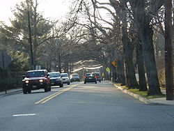
. In Ho-Ho-Kus, County Route 507 passes through downtown, soon intersecting with County Route 77 (Sheridan Avenue) and County Route 62 (Franklin Turnpike). Route 507 turns westward along the Franklin Turnpike, providing County Route 62's western terminus, paralleling Ho-Ho-Kus Brook and providing access to Ho-Ho-Kus train station
by way of Warren Avenue. Soon after, County Route 507 intersects with County Route 502
(Hollywood Avenue) and becomes concurrent.
 County Route 507 and County Route 502 continue through Ho-Ho-Kus as a two-lane residential highway along the Franklin Turnpike. They soon pass a local cemetery and enter the downtown of Waldwick
, where County Route 502 forks to the west via Wyckoff Avenue. County Route 507 continues northward along Franklin Turnpike, heading through downtown Waldwick as a four-lane arterial, passing east of the local train station
. The highway turns to the northwest once again, returning to the residential surroundings until crossing into Allendale
near Mackay Avenue, where it becomes commercial once again. County Route 507, a two-lane local street, soon intersects with County Route 101 (Orchard Street) in Allendale, and after crossing local parkland, intersects with County Route 90 (Allendale Avenue). County Route 507 continues northward along the Franklin Turnpike through a wooded residential district, which soon dissipates to mostly forestry on the northbound side until County Route 81 (Crescent Avenue), where it becomes residential once again. At the intersection with Arlton Avenue, County Route 507 crosses northward from Allendale and into the borough of Ramsey
. Soon after, the Franklin Turnpike continues northward near Wyckoff Lake and the residential homes nearby. As the highway enters downtown Ramsey, County Route 507 intersects with County Route 87 (East Main Street) and County Route S-81 (Lake Street) and soon after County Route 83 (Airmount Avenue) through a large commercial/residential mix area. The highway continues northward through a now largely residential district, intersecting with New Jersey Route 17 southbound and soon crossing over a two-lane bridge, which soon intersects with Route 17 northbound. County Route 507 continues northward along the Franklin Turnpike through the northern reaches of Ramsey, intersecting with Spring Street. The highway becomes commercial once again, intersecting with Orchard Street, where the route crosses the borough line into Mahwah
.
 In Mahwah, County Route 507 continues northwestward along the Franklin Turnpike, passing a large industrial district and nearby local residences. The road passes east of some local residential complexes, intersecting with County Route 100 (Ramapo Avenue) in downtown Mahwah. Ramapo Avenue heads westward to the Mahwah train station
and the business district. County Route 507 continues northward, paralleling its own business district and soon paralleling the Main Line, maintained by New Jersey Transit. The final stretch of the Franklin Turnpike is mostly commercial, passing several local businesses and intersecting with U.S. Route 202
just south of the state border. This provides the northern terminus of County Route 507 and the Franklin Turnpike continues for a short 0.03 mile (0.0482802 km) long stretch to the New York
state line in Mahwah.
, but an extension (through Ho-Ho-Kus) was later built in 1936 to connect with NJ 2 (today's Route 17.)
County highway
A county highway is a road in the United States and in the Canadian province of Ontario that is designated and/or maintained by the county highway department...
in the U.S. state
U.S. state
A U.S. state is any one of the 50 federated states of the United States of America that share sovereignty with the federal government. Because of this shared sovereignty, an American is a citizen both of the federal entity and of his or her state of domicile. Four states use the official title of...
of New Jersey
New Jersey
New Jersey is a state in the Northeastern and Middle Atlantic regions of the United States. , its population was 8,791,894. It is bordered on the north and east by the state of New York, on the southeast and south by the Atlantic Ocean, on the west by Pennsylvania and on the southwest by Delaware...
. The highway extends 28.37 mi (45.66 km) from Harrison Avenue (CR 508
County Route 508 (New Jersey)
County Route 508 is a county highway in the U.S. state of New Jersey. The highway extends 16.14 miles from Mount Pleasant Avenue in Livingston to Belleville Turnpike in Kearny.-Essex County:...
) on the Kearny
Kearny, New Jersey
Kearny is a town in Hudson County, New Jersey, United States. It was named after Civil War general Philip Kearny. As of the United States 2010 Census, the town population was 40,684. The town is a suburb of the nearby city of Newark....
-Harrison
Harrison, New Jersey
Harrison is a town in Hudson County, New Jersey, United States. As of the 2010 United States Census, the town's population was 13,620. The town is a suburb of the nearby city of Newark, New Jersey.-Geography:Harrison is located at ....
town line to the New York
New York
New York is a state in the Northeastern region of the United States. It is the nation's third most populous state. New York is bordered by New Jersey and Pennsylvania to the south, and by Connecticut, Massachusetts and Vermont to the east...
state line in Mahwah
Mahwah, New Jersey
Mahwah is a township in Bergen County, New Jersey, United States. As of the 2010 United States Census, the township population was 25,890. The name Mahwah is derived from the Lenni Lenape word "mawewi" which means "Meeting Place" or "Place Where Paths Meet".The area that is now Mahwah was...
. Between Ho-Ho-Kus and Mahwah
Mahwah
Mahwah may refer to the following in the U.S. state of New Jersey:*Mahwah River, a tributary of the Ramapo River*Mahwah, New Jersey, a township in Bergen County**Mahwah Township Public Schools, a school district in the above township...
, this highway is known as Franklin Turnpike. At its northern terminus, County Route 507 continues north into the New York State as Orange Avenue, which is a portion of US Route 202.
Harrison to Carlton Hill
County Route 507 begins at an intersection with County Route 508County Route 508 (New Jersey)
County Route 508 is a county highway in the U.S. state of New Jersey. The highway extends 16.14 miles from Mount Pleasant Avenue in Livingston to Belleville Turnpike in Kearny.-Essex County:...
(Harrison Street) in the community of Harrison, New Jersey
Harrison, New Jersey
Harrison is a town in Hudson County, New Jersey, United States. As of the 2010 United States Census, the town's population was 13,620. The town is a suburb of the nearby city of Newark, New Jersey.-Geography:Harrison is located at ....
. The highway progresses northward as Schuyler Street, weaving northward through downtown Harrison. A short distance later, Route 507 passes West Hudson Park and turns to the northeast, entering a mainly commercial district of Harrison. The route soon enters Kearny
Kearny, New Jersey
Kearny is a town in Hudson County, New Jersey, United States. It was named after Civil War general Philip Kearny. As of the United States 2010 Census, the town population was 40,684. The town is a suburb of the nearby city of Newark....
, the westernmost district in Hudson County
Hudson County, New Jersey
Hudson County is the smallest county in New Jersey and one of the most densely populated in United States. It takes its name from the Hudson River, which creates part of its eastern border. Part of the New York metropolitan area, its county seat and largest city is Jersey City.- Municipalities...
and its Arlington district. There, Route 507 continues as Schuyler Avenue, intersecting with the Gunnel Oval, which leads to Kearny Playground. After an intersection with Midland Avenue, the highway crosses New Jersey Transit
New Jersey Transit
The New Jersey Transit Corporation is a statewide public transportation system serving the United States state of New Jersey, and New York, Orange, and Rockland counties in New York State...
's former Boonton Line through Arlington, abandoned on September 20, 2002. After crossing the tracks, County Route 507 continues through a long residential stretch in Arlington, soon forking with the Arlington Memorial Park
Arlington Memorial Park
Arlington Memorial Park is a cemetery located mostly in Kearny in Hudson County, New Jersey, on Schuyler Avenue. A small portion of the cemetery is located across Belleville Turnpike in North Arlington in Bergen County....
, a cemetery at Prospect Place in Kearny. County Route 507 parallels the cemetery, until the intersection with New Jersey Route 7 and County Route 506
County Route 506 (New Jersey)
County Route 506 is a county highway in the U.S. state of New Jersey. The highway extends 10.74 miles from Oak Road in Fairfield to Route 7 at the Passaic River in Belleville.- Route description :...
(the Belleville Turnpike). Here, County Route 507 turns westward along Route 7 and Route 506 while Schuyler Avenue continues northward as Bergen County Route 11. Routes 7, 506 and 507 head west, crossing through a mix of residential homes and local businesses and soon intersecting with Ridge Road (New Jersey Route 17) at its southern terminus on the Kearny / North Arlington
North Arlington, New Jersey
North Arlington is a borough in Bergen County, New Jersey, United States. As of the 2010 United States Census, the borough population was 15,392...
border. From there, the surroundings become vastly residential and at the intersection with Hudson County Route 699 (Passaic Avenue), Route 507 turns northward as River Road along the right-of-way and away from Routes 7 and 506.
From the intersection, County Route 507 continues north through North Arlington, crossing a mix of industrial, commercial and residential residences as it parallels the Passaic River
Passaic River
The Passaic River is a mature surface river, approximately 80 mi long, in northern New Jersey in the United States. The river in its upper course flows in a highly circuitous route, meandering through the swamp lowlands between the ridge hills of rural and suburban northern New Jersey,...
. Soon after, the route passes the local football and baseball fields, approaching the waterfront of the Passaic. County Route 507 soon passes a waterfront park and curves to the northeast away from the Passaic at Riverside County Park. Near the intersection with Bergen County Route 26 (Jauncey Avenue), the route curves to the northwest and becomes Riverside Avenue. County Route 507 continues to parallel Riverside County Park until Park Street, where the park terminates, and after entering Lyndhurst
Lyndhurst, New Jersey
Lyndhurst is a township in Bergen County, New Jersey, United States. As of the 2010 United States Census, the township population was 20,554.Lyndhurst was originally formed as Union Township on February 19, 1852 from portions of Harrison Township...
, the highway intersects with County Route 28 (Park Avenue) near the Passaic. County Route 507 continues northward along Riverside Avenue, passing residences and a large local park before intersecting with County Route 45 (American Legion Avenue) at a fork in the roadway. The route first heads northward and reaches the Passaic River waterfront, where it turns to the northeast and parallels the river before crossing under New Jersey Transit's Main Line
Main Line (NJ Transit)
The Main Line is a rail line owned and operated by New Jersey Transit running from Suffern, New York to Hoboken, New Jersey. It runs daily commuter service and was once the north-south main line of the Erie Lackawanna Railroad...
. County Route 507 enters Rutherford
Rutherford, New Jersey
Rutherford is a borough in Bergen County, New Jersey, United States. As of the 2010 United States Census, the borough population was 18,061. It is an inner-ring suburb of New York City, located west of Midtown Manhattan....
after crossing County Route 30 (Rutherford Avenue), County Route 507 than intersects with New Jersey Route 3 westbound at a partial cloverleaf interchange. There is no interchange for Route 3 eastbound along County Route 507, which continues along the Passaic riverside through a largely residential area. At the intersection with Donaldson Avenue, Route 507 becomes known as Jackson Avenue. After making a skip to the northeast, the road turns back to the northeast through a wooded residential district. At the intersection with County Route 34 (Union Avenue), County Route 507 passes some commercial businesses, but remains highly residential afterwards. After the intersection with County Route 32 (Erie Avenue), the highway crosses the former Erie Railroad
Erie Railroad
The Erie Railroad was a railroad that operated in New York State, New Jersey, Pennsylvania, Ohio, Indiana, and Illinois, originally connecting New York City with Lake Erie...
main line and the site of the former Carlton Hill station
Carlton Hill (Erie Railroad station)
Carlton Hill Station was a former railroad station for the Erie Railroad in the community of Rutherford, New Jersey, United States. Carlton Hill station was the second station along the Erie's main line and the first station after Rutherford Junction, where the Erie's main line forked from the...
. Soon after, County Route 507 passes the former Royce Chemical Standard and Bleachery, where it changes names to Carlton Avenue for entering East Rutherford
East Rutherford, New Jersey
East Rutherford is a borough in Bergen County, New Jersey. As of the 2010 United States Census, the borough population was 8,913. It is an inner-ring suburb of New York City, located west of Midtown Manhattan....
.
East Rutherford to Ho-Ho-Kus
In East Rutherford, County Route 507 turns to the northwest along Carlton Avenue, passing a mixture of residential and commercial residences as the route progresses westward. At the intersection with Locust Avenue, the highway turned northeastward along Locust, intersecting with County Route 14 (Paterson Avenue) in East Rutherford. County Route 507 continues northward, passing local residences for several blocks, until reaching an intersection with Main Avenue near the Passaic River. Locust Avenue crosses the Passaic locally-maintained while County Route 507 turns eastward and heads along Main Avenue, which parallels the Passaic. At a fork, the highway turns to the northwest along Midland Avenue while Main Avenue becomes County Route 61. The highway continues northward along Midland, passing local factories and intersects with River Drive, where County Route 507 turns westward along River while Midland Avenue continues northward as County Route 67. County Route 507 continues westward alongside the Passaic River as a two-lane boulevard through now the city of GarfieldGarfield, New Jersey
Garfield is a city in Bergen County, New Jersey, United States. As of the 2010 United States Census, the city population was 30,487.When the area that is now Garfield was first developed in 1873, it was known as East Passaic. In 1881, the community's name was changed to Garfield in honor of...
. The residences soon dissipate, leaving way for commercial businesses and soon intersecting with County Route 42 (Outwater Lane). However, County Route 507 continues northwestward alongside the Passaic, passing a local waterfall and local residences as it gradually turns northward, crossing under the Garden State Parkway
Garden State Parkway
The Garden State Parkway is a 172.4-mile limited-access toll parkway that stretches the length of New Jersey from the New York line at Montvale, New Jersey, to Cape May at New Jersey's southernmost tip. Its name refers to New Jersey's nickname, the "Garden State." Most New Jersey residents refer...
soon after. A short distance from the Parkway, the highway enters a partial cloverleaf interchange with U.S. Route 46
U.S. Route 46
U.S. Route 46 is an east–west U.S. Highway, running for , completely within the state of New Jersey. The west end is at an interchange with Interstate 80 and Route 94 in Columbia, Warren County on the Delaware River...
, where County Route 507 enters a large commercial district just south of Interstate 80
Interstate 80 in New Jersey
Interstate 80 is a major Interstate Highway in the United States, running from the New York City Metropolitan Area westward to San Francisco, California...
. Interstate 80 interchanges with Route 507 and continues northward, crossing the main line of the New York, Susquehanna and Western Railroad near Summit Avenue. The highway continues northwestward as a mix of residential and commercial businesses partially interchanging with New Jersey Route 4 in now Elmwood Park
Elmwood Park, New Jersey
Elmwood Park is a borough in Bergen County, New Jersey, United States. As of the 2010 United States Census, the borough population was 19,403....
. County Route 507 continues northward along River Drive, weaving its way through many residences and soon a local church. Near the intersection with Berdan Avenue, the commercial district returns to Route 507.
The route continues northward, passing through Fair Lawn
Fair Lawn, New Jersey
Fair Lawn is a borough in Bergen County, New Jersey, United States and a suburban municipality in the New York City Metropolitan Area. As of the 2010 United States Census, the borough's population was 32,457. Fair Lawn was incorporated as a borough by an Act of the New Jersey Legislature on March...
as a four-lane boulevard with businesses and industry paralleling. At an intersection with County Route 77 (Maple Avenue), County Route 507 turns eastward along Maple, following a long stretch of businesses as it progresses northward. Soon after, the highway parallels Fair Lawn Cemetery and Terrace Park before interchanging with New Jersey Route 208 on a partial cloverleaf interchange. South Maple Avenue continues northward as a residential highway, turning from the north to the northeast into the community of Glen Rock
Glen Rock, New Jersey
Glen Rock is a borough in Bergen County, New Jersey, United States. As of the 2010 United States Census, the borough population was 11,601.-History:...
, where it crosses New Jersey Transit's Bergen County Line
Bergen County Line
The Bergen County Line is a commuter rail line and service owned and operated by New Jersey Transit in the U.S. state of New Jersey. The line loops off the Main Line between the Meadowlands and Glen Rock, with trains continuing in either direction along the Main Line...
. In Glen Rock, County Route 507 intersects with County Route 134 (Rock Road), which provides access to both of Glen Rock's train stations, nearby Glen Rock-Boro Hall and the Main Line station a short distance further. South Maple Avenue continues northward through the residential districts of Glen Rock, intersecting soon with County Route 79 (Ackerman Avenue). After turning northeastward once again, County Route 507 intersects with County Route S-79 (Prospect Street) and through a largely residential portion of now Ridgewood
Ridgewood, New Jersey
Ridgewood is a village in Bergen County, New Jersey, United States. As of the 2010 United States Census, the village population was 24,958. Ridgewood is an affluent suburban bedroom community of New York City, located approximately northwest of Midtown Manhattan.The Village of Ridgewood was...
. The route the enters downtown Ridgewood, intersecting with County Route 80 for a short distance, which turns westward on Franklin Avenue soon after. In downtown Ridgewood, County Route 507 passes the local high school, the Veterans Memorial Park and Graydon Park before intersecting with County Route 110 (Linwood Avenue) soon after. County Route 507, now known as North Maple Avenue, continues northward, paralleling a nearby brook past an intersection with County Route 82. After curving to the northeast at Undercliff Court, the highway continues north through Ridgewood until crossing 1st Street, where it enters the town of Ho-Ho-Kus
Ho-Ho-Kus, New Jersey
Ho-Ho-Kus is a borough in Bergen County, New Jersey, United States. As of the 2010 census, the borough population was 4,078. It is the home of several historical landmarks, including the Ho-Ho-Kus Inn and The Hermitage....
. In Ho-Ho-Kus, County Route 507 passes through downtown, soon intersecting with County Route 77 (Sheridan Avenue) and County Route 62 (Franklin Turnpike). Route 507 turns westward along the Franklin Turnpike, providing County Route 62's western terminus, paralleling Ho-Ho-Kus Brook and providing access to Ho-Ho-Kus train station
Ho-Ho-Kus (NJT station)
Ho-Ho-Kus Station is a New Jersey Transit station served by Bergen County Line and Main Line trains. The station is located It is located in Ho-Ho-Kus, New Jersey, at Brookside Avenue and 1st Street, across the bridge on Warren Avenue from Franklin Turnpike. The station's current westbound...
by way of Warren Avenue. Soon after, County Route 507 intersects with County Route 502
County Route 502 (New Jersey)
County Route 502 is a county highway in the U.S. state of New Jersey. The highway extends 23.79 miles from Paterson-Hamburg Turnpike in Wayne to Palisades Boulevard in Alpine....
(Hollywood Avenue) and becomes concurrent.
Waldwick to Mahwah
Waldwick, New Jersey
Waldwick is a borough in Bergen County, New Jersey, United States. As of the 2010 United States Census, the borough population was 9,625.-Geography:Waldwick is located at ....
, where County Route 502 forks to the west via Wyckoff Avenue. County Route 507 continues northward along Franklin Turnpike, heading through downtown Waldwick as a four-lane arterial, passing east of the local train station
Waldwick (NJT station)
Waldwick Station is a New Jersey Transit rail station served by Main Line and Bergen County Line trains. It is located in Waldwick, New Jersey, United States. The station is located at the intersection of West Prospect Street, Lafayette Place and Hewson Avenue. The Waldwick Station is the terminus...
. The highway turns to the northwest once again, returning to the residential surroundings until crossing into Allendale
Allendale, New Jersey
Allendale is a borough in Bergen County, New Jersey, United States. As of the 2010 United States Census, the borough population was 6,505.Allendale was formed on November 8, 1894 from portions of Franklin Township, Hohokus Township and Orvil Township at the height of the Boroughitis phenomenon then...
near Mackay Avenue, where it becomes commercial once again. County Route 507, a two-lane local street, soon intersects with County Route 101 (Orchard Street) in Allendale, and after crossing local parkland, intersects with County Route 90 (Allendale Avenue). County Route 507 continues northward along the Franklin Turnpike through a wooded residential district, which soon dissipates to mostly forestry on the northbound side until County Route 81 (Crescent Avenue), where it becomes residential once again. At the intersection with Arlton Avenue, County Route 507 crosses northward from Allendale and into the borough of Ramsey
Ramsey, New Jersey
Ramsey is a borough in Bergen County, New Jersey, United States. It is a suburb of New York City, located northwest of Midtown Manhattan. As of the 2010 United States Census, the borough population was 14,473....
. Soon after, the Franklin Turnpike continues northward near Wyckoff Lake and the residential homes nearby. As the highway enters downtown Ramsey, County Route 507 intersects with County Route 87 (East Main Street) and County Route S-81 (Lake Street) and soon after County Route 83 (Airmount Avenue) through a large commercial/residential mix area. The highway continues northward through a now largely residential district, intersecting with New Jersey Route 17 southbound and soon crossing over a two-lane bridge, which soon intersects with Route 17 northbound. County Route 507 continues northward along the Franklin Turnpike through the northern reaches of Ramsey, intersecting with Spring Street. The highway becomes commercial once again, intersecting with Orchard Street, where the route crosses the borough line into Mahwah
Mahwah, New Jersey
Mahwah is a township in Bergen County, New Jersey, United States. As of the 2010 United States Census, the township population was 25,890. The name Mahwah is derived from the Lenni Lenape word "mawewi" which means "Meeting Place" or "Place Where Paths Meet".The area that is now Mahwah was...
.
Mahwah (NJT station)
Mahwah Station is a New Jersey Transit rail station served by Main Line and Bergen County Line trains. It is located in Mahwah, New Jersey and is the last station in the state of New Jersey on the Main/Bergen line going westbound....
and the business district. County Route 507 continues northward, paralleling its own business district and soon paralleling the Main Line, maintained by New Jersey Transit. The final stretch of the Franklin Turnpike is mostly commercial, passing several local businesses and intersecting with U.S. Route 202
U.S. Route 202 in New Jersey
U.S. Route 202 is a U.S. Highway running from New Castle, Delaware northeast to Bangor, Maine. In the U.S. state of New Jersey, the route runs from the New Hope-Lambertville Toll Bridge over the Delaware River at the Pennsylvania border in Delaware Township, Hunterdon County near Lambertville...
just south of the state border. This provides the northern terminus of County Route 507 and the Franklin Turnpike continues for a short 0.03 mile (0.0482802 km) long stretch to the New York
New York
New York is a state in the Northeastern region of the United States. It is the nation's third most populous state. New York is bordered by New Jersey and Pennsylvania to the south, and by Connecticut, Massachusetts and Vermont to the east...
state line in Mahwah.
History
Originally, the Franklin Turnpike went from Mahwah through WaldwickWaldwick, New Jersey
Waldwick is a borough in Bergen County, New Jersey, United States. As of the 2010 United States Census, the borough population was 9,625.-Geography:Waldwick is located at ....
, but an extension (through Ho-Ho-Kus) was later built in 1936 to connect with NJ 2 (today's Route 17.)