

Triangulation station
Encyclopedia
A triangulation station, also known as a triangulation pillar, trigonometrical station, trigonometrical point, trig station, trig beacon or trig point, and sometimes informally as a trig, is a fixed surveying
Surveying
See Also: Public Land Survey SystemSurveying or land surveying is the technique, profession, and science of accurately determining the terrestrial or three-dimensional position of points and the distances and angles between them...
station, used in geodetic surveying and other surveying projects in its vicinity. The names of triangulation stations vary regionally; they are generally known as trigonometrical stations in North America
North America
North America is a continent wholly within the Northern Hemisphere and almost wholly within the Western Hemisphere. It is also considered a northern subcontinent of the Americas...
, trig points in the United Kingdom
United Kingdom
The United Kingdom of Great Britain and Northern IrelandIn the United Kingdom and Dependencies, other languages have been officially recognised as legitimate autochthonous languages under the European Charter for Regional or Minority Languages...
, New Zealand
New Zealand
New Zealand is an island country in the south-western Pacific Ocean comprising two main landmasses and numerous smaller islands. The country is situated some east of Australia across the Tasman Sea, and roughly south of the Pacific island nations of New Caledonia, Fiji, and Tonga...
and Australia
Australia
Australia , officially the Commonwealth of Australia, is a country in the Southern Hemisphere comprising the mainland of the Australian continent, the island of Tasmania, and numerous smaller islands in the Indian and Pacific Oceans. It is the world's sixth-largest country by total area...
, and trig beacons in South Africa
South Africa
The Republic of South Africa is a country in southern Africa. Located at the southern tip of Africa, it is divided into nine provinces, with of coastline on the Atlantic and Indian oceans...
; triangulation pillar is the more formal term for the concrete columns found in the UK.
Use
The station is usually set up by a governmentGovernment
Government refers to the legislators, administrators, and arbitrators in the administrative bureaucracy who control a state at a given time, and to the system of government by which they are organized...
with known coordinate and elevation
Elevation
The elevation of a geographic location is its height above a fixed reference point, most commonly a reference geoid, a mathematical model of the Earth's sea level as an equipotential gravitational surface ....
published. Many stations are located on hilltops
Summit (topography)
In topography, a summit is a point on a surface that is higher in elevation than all points immediately adjacent to it. Mathematically, a summit is a local maximum in elevation...
for the purposes of visibility. A graven metal plate on the top of a pillar may provide a mounting point for a theodolite
Theodolite
A theodolite is a precision instrument for measuring angles in the horizontal and vertical planes. Theodolites are mainly used for surveying applications, and have been adapted for specialized purposes in fields like metrology and rocket launch technology...
or reflector
Reflector
-Science:* Reflector, a device that causes reflection * Reflector , used to control lighting contrast* Reflecting telescope* Reflector , the part of an antenna that reflects radio waves...
.
Trigonometrical stations are grouped together to form a network of triangulation
Triangulation
In trigonometry and geometry, triangulation is the process of determining the location of a point by measuring angles to it from known points at either end of a fixed baseline, rather than measuring distances to the point directly...
. Positions of all land boundaries, roads, railways, bridges and other infrastructure
Infrastructure
Infrastructure is basic physical and organizational structures needed for the operation of a society or enterprise, or the services and facilities necessary for an economy to function...
can be accurately located by the network, a task that is essential to the construction of modern infrastructure. Apart from the known stations set up by government, some temporary trigonometrical stations are set up near construction sites for monitoring the precision and progress of construction.
Some trigonometrical stations use the Global Positioning System
Global Positioning System
The Global Positioning System is a space-based global navigation satellite system that provides location and time information in all weather, anywhere on or near the Earth, where there is an unobstructed line of sight to four or more GPS satellites...
for greatly improved accuracy.
Although many stations are no longer required for surveying purposes, they remain useful to hikers
Hiking
Hiking is an outdoor activity which consists of walking in natural environments, often in mountainous or other scenic terrain. People often hike on hiking trails. It is such a popular activity that there are numerous hiking organizations worldwide. The health benefits of different types of hiking...
as navigation
Navigation
Navigation is the process of monitoring and controlling the movement of a craft or vehicle from one place to another. It is also the term of art used for the specialized knowledge used by navigators to perform navigation tasks...
al aids when hill-walking.
United Kingdom
United Kingdom
The United Kingdom of Great Britain and Northern IrelandIn the United Kingdom and Dependencies, other languages have been officially recognised as legitimate autochthonous languages under the European Charter for Regional or Minority Languages...
, trig points are typically concrete pillars, and were erected by the Ordnance Survey
Ordnance Survey
Ordnance Survey , an executive agency and non-ministerial government department of the Government of the United Kingdom, is the national mapping agency for Great Britain, producing maps of Great Britain , and one of the world's largest producers of maps.The name reflects its creation together with...
.
The process of placing trig points on top of prominent hills and mountains began in 1935 to assist in the accurate retriangulation of Great Britain
Retriangulation of Great Britain
The retriangulation of Great Britain was a triangulation project which involved erecting concrete pillars on prominent hilltops throughout Great Britain...
. In low-lying or flat areas some trig points may be only a few metres above sea level. When all the trig points were in place, it was possible, in clear weather, to see at least two other trig points from any one trig point. Careful measurements of the angles between the lines-of-sight of the other trig points then allowed the construction of a system of triangles which could then be referenced back to a single baseline to construct a highly accurate measurement system that covered the entire country.
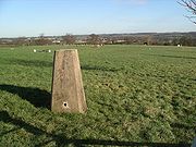
In most of the United Kingdom, trig points are truncated square concrete (occasionally stone) pyramid
Pyramid
A pyramid is a structure whose outer surfaces are triangular and converge at a single point. The base of a pyramid can be trilateral, quadrilateral, or any polygon shape, meaning that a pyramid has at least three triangular surfaces...
s or obelisk
Obelisk
An obelisk is a tall, four-sided, narrow tapering monument which ends in a pyramid-like shape at the top, and is said to resemble a petrified ray of the sun-disk. A pair of obelisks usually stood in front of a pylon...
s tapering towards the top. On the top a brass plate with three arms and a central depression is fixed and this is used to mount and centre a theodolite used to take angular measurements to neighbouring trig points. A benchmark
Benchmark (surveying)
The term bench mark, or benchmark, originates from the chiseled horizontal marks that surveyors made in stone structures, into which an angle-iron could be placed to form a "bench" for a leveling rod, thus ensuring that a leveling rod could be accurately repositioned in the same place in the future...
is usually set on the side, marked with the letters "O S B M" (Ordnance Survey Bench Mark) and the reference number of the trig point. Within and below the visible trig point, there are concealed reference marks whose National Grid References are precisely known. The standard trig point design is credited to Brigadier
Brigadier
Brigadier is a senior military rank, the meaning of which is somewhat different in different military services. The brigadier rank is generally superior to the rank of colonel, and subordinate to major general....
Martin Hotine
Martin Hotine
Brigadier Martin Hotine CMG CBE was the head of the Trigonometrical and Levelling Division of the Ordnance Survey responsible for the 26 year long retriangulation of Great Britain and was the first Director General of the Directorate of Overseas Surveys .According to Nicholas Crane :...
CMG CBE
CBE
CBE and C.B.E. are abbreviations for "Commander of the Order of the British Empire", a grade in the Order of the British Empire.Other uses include:* Chemical and Biochemical Engineering...
(1898–1968), the then head of the Trigonometrical and Levelling
Levelling
Levelling or leveling is a branch of surveying, the object of which is1) To find the elevation of a given point with respect to the given or assumed Datum.2) to establish a point at a given elevation with respect to the given or assumed Datum....
Division of the Ordnance Survey. Many of them are now disappearing from the countryside as their function has largely been superseded by aerial photography
Aerial photography
Aerial photography is the taking of photographs of the ground from an elevated position. The term usually refers to images in which the camera is not supported by a ground-based structure. Cameras may be hand held or mounted, and photographs may be taken by a photographer, triggered remotely or...
and digital mapping
Digital mapping
Digital mapping is the process by which a collection of data is compiled and formatted into a virtual image. The primary function of this technology is to produce maps that give accurate representations of a particular area, detailing major road arteries and other points of interest...
using laser
Laser
A laser is a device that emits light through a process of optical amplification based on the stimulated emission of photons. The term "laser" originated as an acronym for Light Amplification by Stimulated Emission of Radiation...
s and GPS
Global Positioning System
The Global Positioning System is a space-based global navigation satellite system that provides location and time information in all weather, anywhere on or near the Earth, where there is an unobstructed line of sight to four or more GPS satellites...
measurements.
A series of books has been written by teacher and journalist Peter Naldrett to encourage people to visit triangulation pillars as part of countryside hikes. The Trigpoint Walks series includes The Dark Peak, The White Peak, The National Park Fringe and Pembrokeshire.
Australia
A national geodetic survey and adjustment carried out in the early 1970s in AustraliaAustralia
Australia , officially the Commonwealth of Australia, is a country in the Southern Hemisphere comprising the mainland of the Australian continent, the island of Tasmania, and numerous smaller islands in the Indian and Pacific Oceans. It is the world's sixth-largest country by total area...
has left a legacy of trig stations consisting of a ground mark with a white quadripod supporting a black disc above the ground mark. These trig stations are clearly visible for many kilometres and useful for hikers.
Spain
In SpainSpain
Spain , officially the Kingdom of Spain languages]] under the European Charter for Regional or Minority Languages. In each of these, Spain's official name is as follows:;;;;;;), is a country and member state of the European Union located in southwestern Europe on the Iberian Peninsula...
there are 11000 triangulation stations, concrete buildings which typically consist of a cylinder 120 cm high and 30 cm diameter over a concrete cubic base.
They were erected by the Instituto Geográfico Nacional, and are marked with a metallic label with the warning: "The destruction of this sign is punishable by law".
See also
- GeodesyGeodesyGeodesy , also named geodetics, a branch of earth sciences, is the scientific discipline that deals with the measurement and representation of the Earth, including its gravitational field, in a three-dimensional time-varying space. Geodesists also study geodynamical phenomena such as crustal...
- Ordnance SurveyOrdnance SurveyOrdnance Survey , an executive agency and non-ministerial government department of the Government of the United Kingdom, is the national mapping agency for Great Britain, producing maps of Great Britain , and one of the world's largest producers of maps.The name reflects its creation together with...
- Retriangulation of Great BritainRetriangulation of Great BritainThe retriangulation of Great Britain was a triangulation project which involved erecting concrete pillars on prominent hilltops throughout Great Britain...
- Trigpointing is a 'sport' which has grown for people to individually go out, find and log the location of trig points.