
Triangulation
Overview
Trigonometry
Trigonometry is a branch of mathematics that studies triangles and the relationships between their sides and the angles between these sides. Trigonometry defines the trigonometric functions, which describe those relationships and have applicability to cyclical phenomena, such as waves...
and geometry
Geometry
Geometry arose as the field of knowledge dealing with spatial relationships. Geometry was one of the two fields of pre-modern mathematics, the other being the study of numbers ....
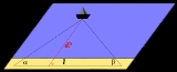
, triangulation is the process of determining the location of a point by measuring angles
Angles
The Angles is a modern English term for a Germanic people who took their name from the ancestral cultural region of Angeln, a district located in Schleswig-Holstein, Germany...
to it from known points at either end of a fixed baseline, rather than measuring distances to the point directly (trilateration
Trilateration
In geometry, trilateration is the process of determinating absolute or relative locations of points by measurement of distances, using the geometry of circles, spheres or triangles. In addition to its interest as a geometric problem, trilateration does have practical applications in surveying and...
). The point can then be fixed as the third point of a triangle with one known side and two known angles.
Triangulation can also refer to the accurate surveying
Surveying
See Also: Public Land Survey SystemSurveying or land surveying is the technique, profession, and science of accurately determining the terrestrial or three-dimensional position of points and the distances and angles between them...
of systems of very large triangles, called triangulation networks.
Unanswered Questions