
Transportation in Vancouver
Encyclopedia
Transportation in Vancouver
has many of the features of modern cities worldwide and some interesting differences. Unlike many large metropolis
es, Vancouver has no freeways into or through the downtown area. A proposed freeway through the downtown was rejected in the 1960s by a coalition of citizens, community leaders and planners. This event "signalled the emergence of a new concept of the urban landscape
"http://www.straight.com/content.cfm?id=8375 and has been a consistent element of city planning ever since.
As the city is surrounded by water on three sides, it has several bridge
s to the north and south. Although similar to most other cities in that the automobile serves as the primary mode of transport, it does have alternatives, such as the longest automated light metro system in the world and an extensive network of bike routes
.
 The Metro Vancouver operates a regional rapid mass transit network, under the auspices of the South Coast British Columbia Transportation Authority (formerly Greater Vancouver Transportation Authority). Known as TransLink, it is responsible for all aspects of municipal transportation. In addition to public transport, TransLink is also responsible for maintaining roads and providing ferry service within the Lower Mainland
.
. Service in West Vancouver and Lions Bay is contracted through West Vancouver Blue Bus
.
All buses are wheelchair-accessible and a large number carry bike racks, able to carry one or two wheelchairs and bicycles respectively. Vancouver is actively maintaining and upgrading its trolleybus
fleet. With recent purchases of 188 E40LFRs and 74 E60LFRs from New Flyer Industries
(in 2005–2009), the trolley network serves the downtown core and much of the city of Vancouver proper with fully wheelchair-accessible and bicycle-friendly zero-emission buses.
Certain diesel commuter buses which travel to the suburbs as RapidBus have bicycle racks, wheelchair lifts, and comfortable high back Greyhound-style seats. Frequency in Greater Vancouver ranges from every couple of minutes within downtown Vancouver to two to three trips a day in far-flung suburbs such as Maple Ridge
, Abbotsford, and Aldergrove. (For a complete list of bus routes in Greater Vancouver, please see List of bus routes in Metro Vancouver.)
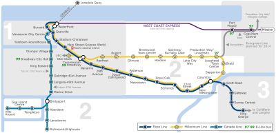
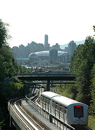 The SkyTrain is an Advanced rapid metro
system operating fully automated trains on three lines. Built for the Expo 86
World's Fair, it has since become the world's longest automated light rapid transit system utilizing the world's longest transit-only bridge, the SkyBridge. The Expo and Millennium Lines link downtown to the suburbs of Burnaby, New Westminster, and Surrey
.
A third rapid transit line connecting downtown Vancouver to central Richmond
and the Vancouver International Airport
, known as the Canada Line
, started operation on August 17, 2009. It utilizes Hyundai Rotem instead of the Advanced rapid metro
used on the first two lines.
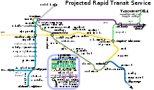
A fourth line, the Evergreen Line, to Port Moody
and Coquitlam
is scheduled to be completed by the end of 2014.
Planning is currently underway for a $2 billion extension to the Millennium Line. The extension will start at the current VCC-Clark SkyTrain station terminus, then run under the Broadway Corridor to terminate at the University of British Columbia
.
Once the announced routes are complete, there will be a total of four lines in the SkyTrain metro network (Expo Line, Millennium Line, Canada Line, Evergreen Line) covering a majority of the Metro Vancouver region. Long range plans for future lines are being visioned but no additional routes have been formally announced.
around False Creek
to Waterfront Station
and then on to Stanley Park
using a combination of modern low-floor tram
s and heritage streetcar
s. Currently, the Vancouver Downtown Historic Railway
is running the phase-zero route, Granville Island-Main Street SkyTrain station, in the summer months, as a demonstration.
From January 21 to March 21, 2010, a free demonstration service called the "Olympic Line" (named after the 2010 Winter Olympics
) ran along 1.8 km of the Downtown Historic Railway, from Granville Island
to Olympic Village Station
, using two Bombardier Flexity Outlook
streetcars borrowed from the Brussels tramway
.
Future plans are being developed, which may extend the streetcar network into Yaletown making a ring around the downtown peninsula as phase two. Longer range plans are being discussed that may possibly extend the streetcar from Granville Island further west into the Arbutus corridor, east along Hastings Street and/or south along Main Street. No formal extensions have yet been announced past phase 1.
 The West Coast Express, a heavy commuter rail train, serves Port Moody, Coquitlam, Port Coquitlam, Pitt Meadows, Maple Ridge
, and Mission
. These services have an integrated ticketing
system.
across Burrard Inlet
. There are three ferries in the fleet, which is owned and operated by the Coast Mountain Bus Company. The newest vessel was put into service in 2009.
s (also known as bike boulevards), streets that have extensive traffic calming
measures such as traffic circles, and signal control to facilitate crossing of major roads. Neighbourhood
s are encouraged to plant and care for the circles and boulevards and add public art
along bike routes.
Since 2004, with the implementation of the Downtown Transportation Plan http://vancouver.ca/dtp/ the City has been adding more bicycle lanes on roads in the densely populated downtown core, signalling its desire to encourage greater commuter use of bicycles. Canada census shows that cycling mode share for the City is 3.7% as compared to 1.7% for the Metro Vancouver area. In neighbourhoods such as Point Grey, Kitsilano, Mount Pleasant at Grandview Woodlands the cycling mode share can be over 10%. Within the downtown core, the combined walking and cycling mode is as high as 50%. The City of Vancouver is continuing to provide additional racks and other types of Bike Parking. A lack of separated facilities in the downtown core and poor bridge crossings remain as an obstacle to provide facilities that serve the needs of novice and advanced cyclists.
With its vibrant cycling community Vancouver's monthly Critical Mass rides, on the last Friday of every month, attract hundreds of cyclists in what have become Canada's largest Critical Mass rides. As documented in the film You Never Bike Alone (2007) http://www.youneverbikealone.com, these rides have spawned similarly styled rides, including the Midnight Mass bike ride, which happens twice a month (at midnight) and World Naked Bike Ride (in June). Bike Polo, freak bikes, bicycle car-cass, and bicycle performance rides are also growing in popularity.
The Central Valley Greenway
, a 25-kilometre green
bicycle corridor
, was officially opened on June 27, 2009. This route forms a regional connection linking downtown Vancouver to Burnaby and New Westminster. Within the City of Vancouver the Central Valley Greenway is almost entirely separated from traffic and counts completed by the City of Vancouver show that almost 2000 cyclists per day were using this route within one month of the opening.
Translink permits two bicycles aboard each SkyTrain
car at all times except in the peak direction at morning and afternoon rush periods. Canada Line Skytrain permits one bicycle per car with no limitations on time of day or direction.
Most buses operating within the city of Vancouver are now equipped with bicycle racks.http://www.translink.bc.ca/Transportation_Services/Bikes/Cycling_OnTransit.asp Seabus allows up to six bicycles per sailing during all hours of operation.
On May 7, 2009, Vancouver City Council
approved a bicycle lane trial on the Burrard Bridge which began on July 13. It saw the southbound motor-vehicle curb lane and the northbound-side sidewalk allocated to bicycles, with the southbound-side sidewalk allocated to pedestrians. The reassigned lane was separated from motor vehicles by a physical barrier. As part of the trial, traffic pattern changes to accommodate feeder bicycle traffic were also completed on Pacific St. next to the North bridgehead over complaints from local merchants that cited lack of consultation and a negative impact on their businesses. Three days into the trial, a local merchant reported a 46% drop in sales compared to the same days the year before.
Two weeks into the trial, the City of Vancouver released a data report showing daily bicycle travel across the bridge had increased by an average of 30%. The same report indicated little change in pedestrian trips, a slight drop in motor vehicle trips, but no change in motor vehicle travel times between 12th Avenue and Georgia Street along Burrard via the bridge. Six weeks into the trial another local merchant reported a 25% drop in sales, and a local restaurant reported a 30% drop in sales.
On August 24, 2009, the Vancouver Police Department
announced a sharp increase in bicycle theft, with the first 3 weeks of August experiencing a 53 percent increase in thefts over 2008. Constable Jana McGuinness, Vancouver Police spokeswoman was quoted as saying, "there is no link between the increase in bike thefts and the recent dedicated bike lanes on Burrard Bridge."
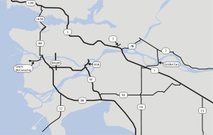 Municipal bylaws and geography have protected Vancouver from the spread of urban freeways, and the only freeway within city limits is Highway 1
, which passes through the eastern edge of the city. All other limited-access routes entering the city (Highway 99, Knight Street
, Grant McConachie Way
), cease being freeways before they enter Vancouver's city limits.
The reason for the lack of freeways in Vancouver is primarily due to the protests of concerned citizens as the city was being developed. During the late 1950s proposals were made by the City to put a freeway through the heart of Chinatown. The Chinese community joined together with white supporters to prevent the freeway from being implemented and by 1971 Chinatown was declared a historical area. The only sections built were the Dunsmuir and Georgia
viaducts, which are now low-speed streets.http://vancouver.ca/commsvcs/planning/chinatown/history/index.htm
(YVR), located on Sea Island
in the City of Richmond
, immediately south of Vancouver. YVR is the second busiest airport in Canada
and one of the busiest international airport
s on the west coast of North America.
Vancouver Harbour Water Aerodrome
on Burrard Inlet
and a heliport
near Waterfront Station link downtown directly to Victoria
, Nanaimo and YVR.
 Rail service is operated from the following stations:
terminals serve the Greater Vancouver area. One is to the northwest at Horseshoe Bay in West Vancouver
, and the other is to the south, at Tsawwassen
. Routes link the mainland to Vancouver Island
, the Sunshine Coast
, and the Gulf Islands
.
are private companies that operate passenger and bicycle ferries connecting the downtown peninsula with Granville Island
and the False Creek
neighbourhoods. English Bay Launch
operates daily scheduled foot-passenger water taxi
service between Granville Island
, Coal Harbour
and Bowen Island
. Coastal Link Ferries
operates daily scheduled foot-passenger water taxi
service between Coal Harbour, West Vancouver, and Bowen Island.
companies operate 24 hour service in Vancouver, including Yellow Cabs, Vancouver Taxi, Black Top Cabs, and MacLure's Cabs. Taxis and drivers are regulated by the city and, as of 2006, 477 licensed cabs operate in the city, including 59 wheelchair-accessible vehicles.http://vancouver.ca/ctyclerk/councillors/mayor/announcements/2006/110806.htm A taxi ride to or from Vancouver International Airport
costs approximately $22–$26.http://www.yvr.ca/guide/toandfrom/taxis.asp Cabs in Vancouver are powered by gasoline
, natural gas
, and electricity
. Limousine
services are also readily available.
City
Vancouver
Vancouver is a coastal seaport city on the mainland of British Columbia, Canada. It is the hub of Greater Vancouver, which, with over 2.3 million residents, is the third most populous metropolitan area in the country,...
has many of the features of modern cities worldwide and some interesting differences. Unlike many large metropolis
Metropolis
A metropolis is a very large city or urban area which is a significant economic, political and cultural center for a country or region, and an important hub for regional or international connections and communications...
es, Vancouver has no freeways into or through the downtown area. A proposed freeway through the downtown was rejected in the 1960s by a coalition of citizens, community leaders and planners. This event "signalled the emergence of a new concept of the urban landscape
Urban planning
Urban planning incorporates areas such as economics, design, ecology, sociology, geography, law, political science, and statistics to guide and ensure the orderly development of settlements and communities....
"http://www.straight.com/content.cfm?id=8375 and has been a consistent element of city planning ever since.
As the city is surrounded by water on three sides, it has several bridge
Bridge
A bridge is a structure built to span physical obstacles such as a body of water, valley, or road, for the purpose of providing passage over the obstacle...
s to the north and south. Although similar to most other cities in that the automobile serves as the primary mode of transport, it does have alternatives, such as the longest automated light metro system in the world and an extensive network of bike routes
Segregated cycle facilities
Segregated cycle facilities are marked lanes, tracks, shoulders and paths designated for use by cyclists from which motorised traffic is generally excluded...
.
Public transportation
Lower Mainland
The Lower Mainland is a name commonly applied to the region surrounding and including Vancouver, British Columbia, Canada. As of 2007, 2,524,113 people live in the region; sixteen of the province's thirty most populous municipalities are located there.While the term Lower Mainland has been...
.
Bus service
Bus service operates throughout most the region under a private subsidiary known as Coast Mountain Bus CompanyCoast Mountain Bus Company
Coast Mountain Bus Company is the contract operator for bus transit services in Metro Vancouver and is a wholly owned subsidiary of the South Coast British Columbia Transportation Authority known locally as TransLink, the entity responsible for transit...
. Service in West Vancouver and Lions Bay is contracted through West Vancouver Blue Bus
West Vancouver Blue Bus
West Vancouver Blue Bus Transit system began in 1912, and is the oldest continuously operated, municipal system in North America. These buses are part of the TransLink network but continue to be owned and operated by the District Municipality of West Vancouver under a contract to...
.
All buses are wheelchair-accessible and a large number carry bike racks, able to carry one or two wheelchairs and bicycles respectively. Vancouver is actively maintaining and upgrading its trolleybus
Trolleybus
A trolleybus is an electric bus that draws its electricity from overhead wires using spring-loaded trolley poles. Two wires and poles are required to complete the electrical circuit...
fleet. With recent purchases of 188 E40LFRs and 74 E60LFRs from New Flyer Industries
New Flyer Industries
New Flyer Industries Inc. is a bus manufacturer in North America, headquartered in Winnipeg, Manitoba, Canada. It also has factories in Crookston and St. Cloud, Minnesota, USA.-History:...
(in 2005–2009), the trolley network serves the downtown core and much of the city of Vancouver proper with fully wheelchair-accessible and bicycle-friendly zero-emission buses.
Certain diesel commuter buses which travel to the suburbs as RapidBus have bicycle racks, wheelchair lifts, and comfortable high back Greyhound-style seats. Frequency in Greater Vancouver ranges from every couple of minutes within downtown Vancouver to two to three trips a day in far-flung suburbs such as Maple Ridge
Maple Ridge, British Columbia
Maple Ridge is a District Municipality in British Columbia, located in the northeastern section of Metro Vancouver. Maple Ridge has a population of approximately 68,949.-History:...
, Abbotsford, and Aldergrove. (For a complete list of bus routes in Greater Vancouver, please see List of bus routes in Metro Vancouver.)
SkyTrain
Bombardier Advanced Rapid Transit
Advanced Rapid Transit or ART is the current name given to a rapid transit system manufactured by Bombardier Transportation. The original versions look like small subway cars that typically run in two-, four- or six-car trains, but the latest versions are more streamlined two-car articulated...
system operating fully automated trains on three lines. Built for the Expo 86
Expo 86
The 1986 World Exposition on Transportation and Communication, or simply Expo '86, was a World's Fair held in Vancouver, British Columbia, Canada from Friday, May 2 until Monday, October 13, 1986...
World's Fair, it has since become the world's longest automated light rapid transit system utilizing the world's longest transit-only bridge, the SkyBridge. The Expo and Millennium Lines link downtown to the suburbs of Burnaby, New Westminster, and Surrey
Surrey, British Columbia
Surrey is a city in the province of British Columbia, Canada. It is a member municipality of Metro Vancouver, the governing body of the Greater Vancouver Regional District...
.
A third rapid transit line connecting downtown Vancouver to central Richmond
Richmond, British Columbia
Richmond is a coastal city, incorporated in the Canadian province of British Columbia. Part of Metro Vancouver, its neighbouring communities are Vancouver and Burnaby to the north, New Westminster to the east, and Delta to the south, while the Strait of Georgia forms its western border...
and the Vancouver International Airport
Vancouver International Airport
Vancouver International Airport is located on Sea Island in Richmond, British Columbia, Canada, about from Downtown Vancouver. In 2010 it was the second busiest airport in Canada by aircraft movements and passengers , behind Toronto Pearson International Airport, with non-stop flights daily to...
, known as the Canada Line
Canada Line
Canada Line is a rapid transit line in the Metro Vancouver region of British Columbia, Canada. Opened in August 2009, it is the third line in TransLink's SkyTrain metro network, servicing Vancouver, Richmond, and the Vancouver International Airport...
, started operation on August 17, 2009. It utilizes Hyundai Rotem instead of the Advanced rapid metro
Bombardier Advanced Rapid Transit
Advanced Rapid Transit or ART is the current name given to a rapid transit system manufactured by Bombardier Transportation. The original versions look like small subway cars that typically run in two-, four- or six-car trains, but the latest versions are more streamlined two-car articulated...
used on the first two lines.
Future expansion
Officials plan to expand the Expo Line, increasing its capacity and extending its route further into the city of Surrey.A fourth line, the Evergreen Line, to Port Moody
Port Moody, British Columbia
Port Moody is a small, crescent-shaped city in Metro Vancouver, located at the east end of Burrard Inlet in British Columbia, Canada. Port Moody is the smallest of the Tri-Cities, bordered by Coquitlam on the east and south, and Burnaby on the west. The villages of Belcarra and Anmore, along with...
and Coquitlam
Coquitlam, British Columbia
Coquitlam is a city in the Lower Mainland of British Columbia, Canada. Coquitlam is mainly a suburban city, and is one of the 21 municipalities comprising Metro Vancouver. According to the 2007 Canadian Census, it is the 5th-largest city in British Columbia...
is scheduled to be completed by the end of 2014.
Planning is currently underway for a $2 billion extension to the Millennium Line. The extension will start at the current VCC-Clark SkyTrain station terminus, then run under the Broadway Corridor to terminate at the University of British Columbia
University of British Columbia
The University of British Columbia is a public research university. UBC’s two main campuses are situated in Vancouver and in Kelowna in the Okanagan Valley...
.
Once the announced routes are complete, there will be a total of four lines in the SkyTrain metro network (Expo Line, Millennium Line, Canada Line, Evergreen Line) covering a majority of the Metro Vancouver region. Long range plans for future lines are being visioned but no additional routes have been formally announced.
Downtown streetcar
The city is planning the first phase of a downtown streetcar from Granville IslandGranville Island
Granville Island is a peninsula and shopping district in Vancouver, British Columbia, Canada. It is located in False Creek directly across from Downtown Vancouver's peninsula, under the south end of the Granville Street Bridge....
around False Creek
False Creek
False Creek is a short inlet in the heart of Vancouver. It separates downtown from the rest of the city. It was named by George Henry Richards during his Hydrographic survey of 1856-63. Science World is located at its eastern end and the Burrard Street Bridge crosses its western end. False Creek is...
to Waterfront Station
Waterfront Station (Vancouver)
Waterfront Station is a major intermodal public transportation facility and the main transit terminus in Downtown Vancouver, British Columbia, Canada.-Location:...
and then on to Stanley Park
Stanley Park
Stanley Park is a 404.9 hectare urban park bordering downtown Vancouver, British Columbia, Canada. It was opened in 1888 by David Oppenheimer in the name of Lord Stanley of Preston, the Governor-General of Canada....
using a combination of modern low-floor tram
Low-floor tram
A low-floor tram is a tram that has no stair steps between one or more entrances and part or all of the passenger cabin. The low-floor design improves the accessibility of the tram for the public, and also may provide larger windows and more airspace....
s and heritage streetcar
Heritage streetcar
Heritage streetcars or heritage trams are a development of the heritage railways that are becoming popular across the world. As with modern streetcar systems, the vehicles are referred to as trams or tramcars in the United Kingdom, Australasia and certain other places , but as streetcars or...
s. Currently, the Vancouver Downtown Historic Railway
Vancouver Downtown Historic Railway
The Vancouver Downtown Historic Railway is a heritage streetcar line that operates between Granville Island and the Cambie Station in Vancouver, British Columbia, Canada. It operates only on weekends and holidays, usually from May to mid-October, and is aimed primarily at tourists...
is running the phase-zero route, Granville Island-Main Street SkyTrain station, in the summer months, as a demonstration.
From January 21 to March 21, 2010, a free demonstration service called the "Olympic Line" (named after the 2010 Winter Olympics
2010 Winter Olympics
The 2010 Winter Olympics, officially the XXI Olympic Winter Games or the 21st Winter Olympics, were a major international multi-sport event held from February 12–28, 2010, in Vancouver, British Columbia, Canada, with some events held in the suburbs of Richmond, West Vancouver and the University...
) ran along 1.8 km of the Downtown Historic Railway, from Granville Island
Granville Island
Granville Island is a peninsula and shopping district in Vancouver, British Columbia, Canada. It is located in False Creek directly across from Downtown Vancouver's peninsula, under the south end of the Granville Street Bridge....
to Olympic Village Station
Olympic Village Station
Olympic Village Station is a SkyTrain station on the Canada Line in Vancouver, British Columbia, Canada. The use of the term "Olympic" has been licensed for use by the International Olympic Committee.-Location:...
, using two Bombardier Flexity Outlook
Flexity Outlook
The Flexity Outlook is a family of 100% low-floor articulated light-rail trams manufactured by Bombardier Transportation. Part of the larger Flexity product line , Flexity Outlook cars fall into two distinct sub-categories with dramatically different appearances...
streetcars borrowed from the Brussels tramway
Brussels trams
The Brussels tram system is one of the ten largest in the world, carrying some 75.6 million passengers in 2009. Its development demonstrates many of the quandaries that face local public transport planners...
.
Future plans are being developed, which may extend the streetcar network into Yaletown making a ring around the downtown peninsula as phase two. Longer range plans are being discussed that may possibly extend the streetcar from Granville Island further west into the Arbutus corridor, east along Hastings Street and/or south along Main Street. No formal extensions have yet been announced past phase 1.
West Coast Express
Maple Ridge, British Columbia
Maple Ridge is a District Municipality in British Columbia, located in the northeastern section of Metro Vancouver. Maple Ridge has a population of approximately 68,949.-History:...
, and Mission
Mission, British Columbia
Mission, the core of which was formerly known as Mission City, is a district municipality in the province of British Columbia, Canada. It is situated on the north bank of the Fraser River overlooking the City of Abbotsford and with that city is part of the Central Fraser Valley. Mission is the...
. These services have an integrated ticketing
Integrated ticketing
Integrated ticketing allows a person to make a journey that involves transfers within or between different transport modes with a single ticket that is valid for the complete journey, modes being buses, trains, subways, ferries, etc...
system.
SeaBus
The SeaBus is a passenger-only ferry connecting downtown Vancouver and the City of North VancouverNorth Vancouver, British Columbia (city)
The City of North Vancouver is a waterfront municipality on the north shore of Burrard Inlet, directly across from Vancouver, British Columbia. It is the smallest of the three North Shore municipalities, and the most urbanized as well...
across Burrard Inlet
Burrard Inlet
Burrard Inlet is a relatively shallow-sided coastal fjord in southwestern British Columbia, Canada. Formed during the last Ice Age, it separates the City of Vancouver and the rest of the low-lying Burrard Peninsula from the slopes of the North Shore Mountains, home to the communities of West...
. There are three ferries in the fleet, which is owned and operated by the Coast Mountain Bus Company. The newest vessel was put into service in 2009.
Cycling
Vancouver is served by a network of over 400 lane-km of on- and off-road bicycle routes. Most of these routes are local street bikewayBikeway
A Bikeway is a route, way or path which in some manner is specifically designed and /or designated for bicycle travel.-See also:*Bicycle boulevard*Bicycle trail*Bicycle transportation engineering*Foreshoreway*Greenway* List of cycleways...
s (also known as bike boulevards), streets that have extensive traffic calming
Traffic calming
Traffic calming is intended to slow or reduce motor-vehicle traffic in order to improve the living conditions for residents as well as to improve safety for pedestrians and cyclists. Urban planners and traffic engineers have many strategies for traffic calming...
measures such as traffic circles, and signal control to facilitate crossing of major roads. Neighbourhood
Neighbourhood
A neighbourhood or neighborhood is a geographically localised community within a larger city, town or suburb. Neighbourhoods are often social communities with considerable face-to-face interaction among members. "Researchers have not agreed on an exact definition...
s are encouraged to plant and care for the circles and boulevards and add public art
Public art
The term public art properly refers to works of art in any media that have been planned and executed with the specific intention of being sited or staged in the physical public domain, usually outside and accessible to all...
along bike routes.
Since 2004, with the implementation of the Downtown Transportation Plan http://vancouver.ca/dtp/ the City has been adding more bicycle lanes on roads in the densely populated downtown core, signalling its desire to encourage greater commuter use of bicycles. Canada census shows that cycling mode share for the City is 3.7% as compared to 1.7% for the Metro Vancouver area. In neighbourhoods such as Point Grey, Kitsilano, Mount Pleasant at Grandview Woodlands the cycling mode share can be over 10%. Within the downtown core, the combined walking and cycling mode is as high as 50%. The City of Vancouver is continuing to provide additional racks and other types of Bike Parking. A lack of separated facilities in the downtown core and poor bridge crossings remain as an obstacle to provide facilities that serve the needs of novice and advanced cyclists.
With its vibrant cycling community Vancouver's monthly Critical Mass rides, on the last Friday of every month, attract hundreds of cyclists in what have become Canada's largest Critical Mass rides. As documented in the film You Never Bike Alone (2007) http://www.youneverbikealone.com, these rides have spawned similarly styled rides, including the Midnight Mass bike ride, which happens twice a month (at midnight) and World Naked Bike Ride (in June). Bike Polo, freak bikes, bicycle car-cass, and bicycle performance rides are also growing in popularity.
The Central Valley Greenway
Central Valley Greenway
The Central Valley Greenway is a 24-kilometre pedestrian and cyclist route in Metro Vancouver, running from Science World in Vancouver to New Westminster, through Burnaby. The Greenway officially opened on June 27, 2009 with opening celebrations, guided bike tours and walking tours on sections of...
, a 25-kilometre green
Greenway (landscape)
A greenway is a long, narrow piece of land, often used for recreation and pedestrian and bicycle user traffic, and sometimes for streetcar, light rail or retail uses.- Terminology :...
bicycle corridor
Segregated cycle facilities
Segregated cycle facilities are marked lanes, tracks, shoulders and paths designated for use by cyclists from which motorised traffic is generally excluded...
, was officially opened on June 27, 2009. This route forms a regional connection linking downtown Vancouver to Burnaby and New Westminster. Within the City of Vancouver the Central Valley Greenway is almost entirely separated from traffic and counts completed by the City of Vancouver show that almost 2000 cyclists per day were using this route within one month of the opening.
Translink permits two bicycles aboard each SkyTrain
SkyTrain (Vancouver)
SkyTrain is a light rapid transit system in Metro Vancouver, British Columbia, Canada. SkyTrain has of track and uses fully automated trains on grade-separated tracks, running mostly on elevated guideways, which helps SkyTrain to hold consistently high on-time reliability...
car at all times except in the peak direction at morning and afternoon rush periods. Canada Line Skytrain permits one bicycle per car with no limitations on time of day or direction.
Most buses operating within the city of Vancouver are now equipped with bicycle racks.http://www.translink.bc.ca/Transportation_Services/Bikes/Cycling_OnTransit.asp Seabus allows up to six bicycles per sailing during all hours of operation.
On May 7, 2009, Vancouver City Council
Vancouver City Council
Vancouver City Council is the governing body of the City of Vancouver, British Columbia, Canada.The city is governed by the Vancouver Charter, not the Community Charter and the Local Government Act which are used for other municipal governments...
approved a bicycle lane trial on the Burrard Bridge which began on July 13. It saw the southbound motor-vehicle curb lane and the northbound-side sidewalk allocated to bicycles, with the southbound-side sidewalk allocated to pedestrians. The reassigned lane was separated from motor vehicles by a physical barrier. As part of the trial, traffic pattern changes to accommodate feeder bicycle traffic were also completed on Pacific St. next to the North bridgehead over complaints from local merchants that cited lack of consultation and a negative impact on their businesses. Three days into the trial, a local merchant reported a 46% drop in sales compared to the same days the year before.
Two weeks into the trial, the City of Vancouver released a data report showing daily bicycle travel across the bridge had increased by an average of 30%. The same report indicated little change in pedestrian trips, a slight drop in motor vehicle trips, but no change in motor vehicle travel times between 12th Avenue and Georgia Street along Burrard via the bridge. Six weeks into the trial another local merchant reported a 25% drop in sales, and a local restaurant reported a 30% drop in sales.
On August 24, 2009, the Vancouver Police Department
Vancouver Police Department
The Vancouver Police Department is the police force for the City of Vancouver in British Columbia, Canada. It is one of several police departments within the Metro Vancouver Area and is the second largest police force in the province after RCMP "E" Division.VPD was the first Canadian police force...
announced a sharp increase in bicycle theft, with the first 3 weeks of August experiencing a 53 percent increase in thefts over 2008. Constable Jana McGuinness, Vancouver Police spokeswoman was quoted as saying, "there is no link between the increase in bike thefts and the recent dedicated bike lanes on Burrard Bridge."
Freeways
Trans-Canada Highway
The Trans-Canada Highway is a federal-provincial highway system that joins the ten provinces of Canada. It is, along with the Trans-Siberian Highway and Australia's Highway 1, one of the world's longest national highways, with the main route spanning 8,030 km...
, which passes through the eastern edge of the city. All other limited-access routes entering the city (Highway 99, Knight Street
Knight Street
Knight Street is a major nouth-south roadway in Vancouver and Richmond, British Columbia, Canada. It is a four-lane freeway from Westminster Highway in Richmond to Marine Drive in Vancouver, thus serving as an alternate way to exit Vancouver southbound, rather than the Granville Street/Oak Street...
, Grant McConachie Way
Grant McConachie Way
Grant McConachie Way is a three-to-six lane expressway in Richmond and Vancouver, British Columbia, Canada. Named for aviator Grant McConachie, it is the primary access road into Vancouver International Airport on Sea Island. It is also one of the three roads entering Vancouver from the south,...
), cease being freeways before they enter Vancouver's city limits.
The reason for the lack of freeways in Vancouver is primarily due to the protests of concerned citizens as the city was being developed. During the late 1950s proposals were made by the City to put a freeway through the heart of Chinatown. The Chinese community joined together with white supporters to prevent the freeway from being implemented and by 1971 Chinatown was declared a historical area. The only sections built were the Dunsmuir and Georgia
Georgia Viaduct
The Georgia Viaduct is a twinned bridge that acts as a flyover-like overpass in Vancouver, British Columbia. It passes between Rogers Arena and BC Place Stadium and connects Downtown Vancouver with Strathcona.-History:...
viaducts, which are now low-speed streets.http://vancouver.ca/commsvcs/planning/chinatown/history/index.htm
Airport
Vancouver is served by Vancouver International AirportVancouver International Airport
Vancouver International Airport is located on Sea Island in Richmond, British Columbia, Canada, about from Downtown Vancouver. In 2010 it was the second busiest airport in Canada by aircraft movements and passengers , behind Toronto Pearson International Airport, with non-stop flights daily to...
(YVR), located on Sea Island
Sea Island, British Columbia
Sea Island is located in the city of Richmond, British Columbia, directly across the river from Vancouver and fifteen kilometres from Vancouver's downtown core. The island is in the estuary of the Fraser River, giving it a unique ecological environment...
in the City of Richmond
Richmond, British Columbia
Richmond is a coastal city, incorporated in the Canadian province of British Columbia. Part of Metro Vancouver, its neighbouring communities are Vancouver and Burnaby to the north, New Westminster to the east, and Delta to the south, while the Strait of Georgia forms its western border...
, immediately south of Vancouver. YVR is the second busiest airport in Canada
Canada
Canada is a North American country consisting of ten provinces and three territories. Located in the northern part of the continent, it extends from the Atlantic Ocean in the east to the Pacific Ocean in the west, and northward into the Arctic Ocean...
and one of the busiest international airport
International airport
An international airport is any airport that can accommodate flights from other countries and are typically equipped with customs and immigration facilities to handle these flights to and from other countries...
s on the west coast of North America.
Vancouver Harbour Water Aerodrome
Vancouver Harbour Water Aerodrome
Vancouver Harbour Water Airport or Vancouver Coal Harbour Seaplane Base, , is located at Coal Harbour in Vancouver, British Columbia, Canada...
on Burrard Inlet
Burrard Inlet
Burrard Inlet is a relatively shallow-sided coastal fjord in southwestern British Columbia, Canada. Formed during the last Ice Age, it separates the City of Vancouver and the rest of the low-lying Burrard Peninsula from the slopes of the North Shore Mountains, home to the communities of West...
and a heliport
Heliport
A heliport is a small airport suitable only for use by helicopters. Heliports typically contain one or more helipads and may have limited facilities such as fuel, lighting, a windsock, or even hangars...
near Waterfront Station link downtown directly to Victoria
Victoria, British Columbia
Victoria is the capital city of British Columbia, Canada and is located on the southern tip of Vancouver Island off Canada's Pacific coast. The city has a population of about 78,000 within the metropolitan area of Greater Victoria, which has a population of 360,063, the 15th most populous Canadian...
, Nanaimo and YVR.
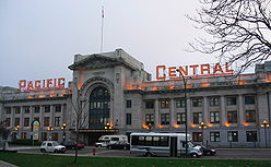
Rail
- Waterfront Station (Vancouver)Waterfront Station (Vancouver)Waterfront Station is a major intermodal public transportation facility and the main transit terminus in Downtown Vancouver, British Columbia, Canada.-Location:...
- Regional railRegional railCommuter rail, also called suburban rail, is a passenger rail transport service that primarily operates between a city center, and the middle to outer suburbs beyond 15km and commuter towns or other locations that draw large numbers of commuters—people who travel on a daily basis...
service operated by West Coast ExpressWest Coast ExpressWest Coast Express is the interregional commuter railway in British Columbia, Canada. Opened in 1995, it links Mission, Maple Ridge, Pitt Meadows, Port Coquitlam, Coquitlam, and Port Moody with Waterfront Station in Downtown Vancouver, where it interchanges with SkyTrain rapid transit, SeaBus and...
to MissionMission, British ColumbiaMission, the core of which was formerly known as Mission City, is a district municipality in the province of British Columbia, Canada. It is situated on the north bank of the Fraser River overlooking the City of Abbotsford and with that city is part of the Central Fraser Valley. Mission is the...
. - Pacific Central StationPacific Central Station (Vancouver)Pacific Central Station in Vancouver, British Columbia, Canada is a railway station that acts as the western terminus of Via Rail's cross-country The Canadian to Toronto and the northern terminus of Amtrak’s Cascades to Seattle, Portland, and Eugene, Oregon...
- Inter-city passenger rail service is operated by Via RailVIA RailVia Rail Canada is an independent crown corporation offering intercity passenger rail services in Canada. It is headquartered near Montreal Central Station at 3 Place Ville-Marie in Montreal, Quebec....
to the interior and Eastern Canada, TorontoTorontoToronto is the provincial capital of Ontario and the largest city in Canada. It is located in Southern Ontario on the northwestern shore of Lake Ontario. A relatively modern city, Toronto's history dates back to the late-18th century, when its land was first purchased by the British monarchy from...
, and intermediate points aboard The CanadianThe CanadianThe Canadian is a Canadian transcontinental passenger train originally operated by the Canadian Pacific Railway between 1955 and 1978. It is currently operated as an Inter-city rail service by Via Rail Canada with service between Union Station in Toronto, Ontario and Pacific Central Station in...
. Inter-city passenger rail service operated by Amtrak CascadesAmtrak CascadesThe Amtrak Cascades is a passenger train route operated by Amtrak in partnership with the states of Washington and Oregon in the Pacific Northwest of the United States and the province of British Columbia in Canada...
to Seattle, WashingtonSeattle, WashingtonSeattle is the county seat of King County, Washington. With 608,660 residents as of the 2010 Census, Seattle is the largest city in the Northwestern United States. The Seattle metropolitan area of about 3.4 million inhabitants is the 15th largest metropolitan area in the country...
. - Rocky Mountaineer StationRocky Mountaineer StationRocky Mountaineer Station in Vancouver, British Columbia, Canada is a railway station which acts as the western terminus of the Rocky Mountaineer train service to Jasper, Banff and Calgary. Prior to 2005, the Vancouver terminus for the Rocky Mountaineer was the Pacific Central Station.The station...
- Tour passenger train services operated by the Rocky MountaineerRocky MountaineerRocky Mountaineer is a Canadian tour company offering Western Canadian vacation packages that operates trains on four rail routes through British Columbia and Alberta.-Background:...
to the interior, Rocky MountainsRocky MountainsThe Rocky Mountains are a major mountain range in western North America. The Rocky Mountains stretch more than from the northernmost part of British Columbia, in western Canada, to New Mexico, in the southwestern United States...
en route to CalgaryCalgaryCalgary is a city in the Province of Alberta, Canada. It is located in the south of the province, in an area of foothills and prairie, approximately east of the front ranges of the Canadian Rockies...
and JasperJasper, AlbertaJasper is a specialized municipality in western Alberta, Canada. It is the commercial centre of Jasper National Park, located in the Canadian Rockies in the Athabasca River valley....
. - North Vancouver Station - Whistler MountaineerWhistler MountaineerWhistler Mountaineer is a rail way service operated by Rocky Mountaineer Vacations tour company, based in Vancouver, British Columbia, Canada who operate vintage trains over numerous sightseeing routes in Western Canada.-Routes:...
started daily service between North Vancouver and WhistlerWhistler, British ColumbiaWhistler is a Canadian resort town in the southern Pacific Ranges of the Coast Mountains in the province of British Columbia, Canada, approximately north of Vancouver...
.
Ferries
Two BC FerryBC Ferries
British Columbia Ferry Services Inc. or BC Ferries is a de facto Crown Corporation that provides all major passenger and vehicle ferry services for coastal and island communities in the Canadian province of British Columbia...
terminals serve the Greater Vancouver area. One is to the northwest at Horseshoe Bay in West Vancouver
West Vancouver, British Columbia
West Vancouver is a district municipality in the province of British Columbia, Canada. A member municipality of Metro Vancouver, the governing body of the Greater Vancouver Regional District, the municipality is northwest of the city of Vancouver on the northern side of English Bay and the...
, and the other is to the south, at Tsawwassen
Tsawwassen, British Columbia
Tsawwassen is a suburban, mostly residential community located on a peninsula in the southwestern corner of the Corporation of Delta, British Columbia, Canada. Tsawwassen provides the only road access to the community of Point Roberts, Washington via 56th Street...
. Routes link the mainland to Vancouver Island
Vancouver Island
Vancouver Island is a large island in British Columbia, Canada. It is one of several North American locations named after George Vancouver, the British Royal Navy officer who explored the Pacific Northwest coast of North America between 1791 and 1794...
, the Sunshine Coast
Sunshine Coast, British Columbia
The Sunshine Coast is a region of the southern mainland coast of British Columbia, on the eastern shore of the Strait of Georgia, and just northwest of Greater Vancouver...
, and the Gulf Islands
Gulf Islands
The Gulf Islands are the islands in the Strait of Georgia , between Vancouver Island and the mainland of British Columbia, Canada....
.
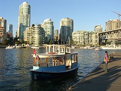
Mini-Ferry
Aquabus and False Creek FerriesFalse Creek Ferries
False Creek Ferries, a division of Granville Island Ferries Ltd, is a privately owned and operated ferry service that operates on False Creek near downtown Vancouver, Canada...
are private companies that operate passenger and bicycle ferries connecting the downtown peninsula with Granville Island
Granville Island
Granville Island is a peninsula and shopping district in Vancouver, British Columbia, Canada. It is located in False Creek directly across from Downtown Vancouver's peninsula, under the south end of the Granville Street Bridge....
and the False Creek
False Creek
False Creek is a short inlet in the heart of Vancouver. It separates downtown from the rest of the city. It was named by George Henry Richards during his Hydrographic survey of 1856-63. Science World is located at its eastern end and the Burrard Street Bridge crosses its western end. False Creek is...
neighbourhoods. English Bay Launch
English Bay Launch
English Bay Launch is a privately owned and operated water taxi service in the Lower Mainland, British Columbia, Canada, which replaced Granville Island Water Taxi Services in the Fall of 2009. It is one of three water taxi services connecting Bowen Island to Vancouver with regularly scheduled...
operates daily scheduled foot-passenger water taxi
Water taxi
A water taxi or water bus, also known as a commuter boat, is a watercraft used to provide public transport, usually but not always in an urban environment. Service may be scheduled with multiple stops, operating in a similar manner to a bus, or on demand to many locations, operating in a similar...
service between Granville Island
Granville Island
Granville Island is a peninsula and shopping district in Vancouver, British Columbia, Canada. It is located in False Creek directly across from Downtown Vancouver's peninsula, under the south end of the Granville Street Bridge....
, Coal Harbour
Coal Harbour
Coal Harbour is the name for a section of Burrard Inlet lying between Vancouver, Canada's downtown peninsula and the Brockton Peninsula of Stanley Park...
and Bowen Island
Bowen Island
Bowen Island, British Columbia, is an island municipality in Howe Sound, is part of the Greater Vancouver Regional District, and is an island included within the jurisdiction of the Islands Trust . Approximately 6 km wide by 12 km long, the island at its closest point is about 2 km...
. Coastal Link Ferries
Coastal Link Ferries
Coastal Link Ferries is a ferry company in the Lower Mainland of British Columbia, Canada.Its vessel, the Coastal Runner, began service in October 2008 between Bowen Island and Vancouver Public Dock in Coal Harbour...
operates daily scheduled foot-passenger water taxi
Water taxi
A water taxi or water bus, also known as a commuter boat, is a watercraft used to provide public transport, usually but not always in an urban environment. Service may be scheduled with multiple stops, operating in a similar manner to a bus, or on demand to many locations, operating in a similar...
service between Coal Harbour, West Vancouver, and Bowen Island.
Taxicabs
Several private taxicabTaxicab
A taxicab, also taxi or cab, is a type of vehicle for hire with a driver, used by a single passenger or small group of passengers, often for a non-shared ride. A taxicab conveys passengers between locations of their choice...
companies operate 24 hour service in Vancouver, including Yellow Cabs, Vancouver Taxi, Black Top Cabs, and MacLure's Cabs. Taxis and drivers are regulated by the city and, as of 2006, 477 licensed cabs operate in the city, including 59 wheelchair-accessible vehicles.http://vancouver.ca/ctyclerk/councillors/mayor/announcements/2006/110806.htm A taxi ride to or from Vancouver International Airport
Vancouver International Airport
Vancouver International Airport is located on Sea Island in Richmond, British Columbia, Canada, about from Downtown Vancouver. In 2010 it was the second busiest airport in Canada by aircraft movements and passengers , behind Toronto Pearson International Airport, with non-stop flights daily to...
costs approximately $22–$26.http://www.yvr.ca/guide/toandfrom/taxis.asp Cabs in Vancouver are powered by gasoline
Gasoline
Gasoline , or petrol , is a toxic, translucent, petroleum-derived liquid that is primarily used as a fuel in internal combustion engines. It consists mostly of organic compounds obtained by the fractional distillation of petroleum, enhanced with a variety of additives. Some gasolines also contain...
, natural gas
Natural gas
Natural gas is a naturally occurring gas mixture consisting primarily of methane, typically with 0–20% higher hydrocarbons . It is found associated with other hydrocarbon fuel, in coal beds, as methane clathrates, and is an important fuel source and a major feedstock for fertilizers.Most natural...
, and electricity
Electricity
Electricity is a general term encompassing a variety of phenomena resulting from the presence and flow of electric charge. These include many easily recognizable phenomena, such as lightning, static electricity, and the flow of electrical current in an electrical wire...
. Limousine
Limousine
A limousine is a luxury sedan or saloon car, especially one with a lengthened wheelbase or driven by a chauffeur. The chassis of a limousine may have been extended by the manufacturer or by an independent coachbuilder. These are called "stretch" limousines and are traditionally black or white....
services are also readily available.
Major streets
Downtown- Georgia StreetGeorgia StreetGeorgia Street is an east-west street in the cities of Vancouver and Burnaby, British Columbia, Canada. Its section in Downtown Vancouver, designated West Georgia Street, serves as one of the primary streets for the financial and central business districts, and is the major transportation corridor...
- Burrard StreetBurrard StreetBurrard Street is a major thoroughfare in Vancouver, British Columbia, Canada. It is the central street of Downtown Vancouver and the Financial District. The street is named for Burrard Inlet, located at its northern terminus, which in turn is named for Sir Harry Burrard-Neale.The street starts at...
- Robson StreetRobson StreetRobson Street is a major southeast-northwest thoroughfare in downtown and West End of Vancouver, British Columbia, Canada. Its core commercial blocks from Burrard Street to Jervis are also known as Robsonstrasse. Its name honours John Robson, a major figure in British Columbia's entry into the...
- Davie Street
- Denman Street
- Pacific Boulevard
City
- Granville StreetGranville StreetGranville Street is a major street in Vancouver, British Columbia, Canada, and part of Highway 99.-Location:Granville Street runs generally north-south through the centre of Vancouver, passing through several neighbourhoods and commercial areas, differing appreciably in their land value and the...
- Main StreetMain Street (Vancouver)Main Street is a major north-south thoroughfare bisecting Vancouver, British Columbia, Canada. It runs from Waterfront Road by Burrard Inlet in the north, to Kent Avenue alongside the north arm of the Fraser River in the south.-Route:...
- BroadwayBroadway (Vancouver)Broadway is a major east-west thoroughfare in the city of Vancouver, British Columbia, Canada. In Vancouver's numbered avenue grid system, it runs in place of a 9th Avenue, between 8th and 10th. The street has four lanes for most of its course...
- Cambie StreetCambie StreetCambie Street is a street in Vancouver, British Columbia, Canada. It is named for Henry John Cambie, chief surveyor of the Canadian Pacific Railway's western division ....
- KingswayKingsway (Vancouver)Kingsway is a major road that crosses through the Canadian cities of Vancouver and Burnaby, British Columbia. Originally called Westminster Road, it was renamed Kingsway in 1913....
- Hastings StreetHastings Street (Vancouver)Hastings Street is one of the most important east-west traffic corridors in the cities of Vancouver and Burnaby, British Columbia, Canada, and used to be a part of the decommissioned Highway 7A...
- Commercial DriveCommercial Drive (Vancouver)Commercial Drive is a roadway in the city of Vancouver in British Columbia, Canada that goes through the neighbourhood of Grandview-Woodland. However, the neighbourhood is so dominated by the businesses, cultural facilities, and residents along Commercial Drive that the area is far better known as...
- Oak StreetOak Street (Vancouver)Oak Street is a major north-south street in Vancouver, British Columbia. The street runs from a three way intersection with 6th Avenue in the north to the Oak Street Bridge in the south, leading towards Richmond...
- King Edward Avenue
- Boundary Road
- Clark Street/Knight StreetKnight StreetKnight Street is a major nouth-south roadway in Vancouver and Richmond, British Columbia, Canada. It is a four-lane freeway from Westminster Highway in Richmond to Marine Drive in Vancouver, thus serving as an alternate way to exit Vancouver southbound, rather than the Granville Street/Oak Street...
- Marine Drive
- Knight StreetKnight StreetKnight Street is a major nouth-south roadway in Vancouver and Richmond, British Columbia, Canada. It is a four-lane freeway from Westminster Highway in Richmond to Marine Drive in Vancouver, thus serving as an alternate way to exit Vancouver southbound, rather than the Granville Street/Oak Street...