

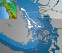
Gulf Islands
Encyclopedia
Island
An island or isle is any piece of sub-continental land that is surrounded by water. Very small islands such as emergent land features on atolls can be called islets, cays or keys. An island in a river or lake may be called an eyot , or holm...
s in the Strait of Georgia
Strait of Georgia
The Strait of Georgia or the Georgia Strait is a strait between Vancouver Island and the mainland coast of British Columbia, Canada. It is approximately long and varies in width from...
(also known as the Gulf of Georgia, explained in detail below), between Vancouver Island
Vancouver Island
Vancouver Island is a large island in British Columbia, Canada. It is one of several North American locations named after George Vancouver, the British Royal Navy officer who explored the Pacific Northwest coast of North America between 1791 and 1794...
and the mainland of British Columbia
British Columbia
British Columbia is the westernmost of Canada's provinces and is known for its natural beauty, as reflected in its Latin motto, Splendor sine occasu . Its name was chosen by Queen Victoria in 1858...
, Canada
Canada
Canada is a North American country consisting of ten provinces and three territories. Located in the northern part of the continent, it extends from the Atlantic Ocean in the east to the Pacific Ocean in the west, and northward into the Arctic Ocean...
.
According to BC Geographical Names (BCGNIS) the name "Gulf Islands" was originally intended and commonly understood to refer to the archipelago at the southern end of the Strait of Georgia—from Gabriola Island
Gabriola Island
Gabriola Island is one of the Gulf Islands in the Strait of Georgia, in British Columbia , Canada. Gabriola lies about east of Nanaimo on Vancouver Island, to which it is linked by ferry...
in the north to Saturna Island
Saturna Island
Saturna Island is a mountainous island, about 31 km² in size, in the Southern Gulf Islands chain of British Columbia. It is situated approximately midway between the Lower Mainland of B.C. and Vancouver Island, and is the most easterly of the Gulf Islands. It is surrounded on three sides by...
in the southeast and D'Arcy Island
D'Arcy Island
D'Arcy Island is an 83-ha island in Haro Strait, south of Sidney Island and east of the Saanich Peninsula .The island was used as a leper colony for Chinese immigrants from 1894 to 1924, and ruins of the building built during that time are still visible...
in the southwest. During the 1990s, however, the name began to be applied to all the islands in the Strait of Georgia, resulting in the introduction of the term "Southern Gulf Islands", which BCGNIS calls a misnomer, to distinguish the original "Gulf Islands" from the rest, which are sometimes called the "Northern Gulf Islands". BCGNIS further notes that Quadra Island
Quadra Island
Quadra Island is an island off the eastern coast of Vancouver Island, British Columbia, Canada, part of the Discovery Islands. It is separated from Vancouver Island by Discovery Passage, and from Cortes Island by Sutil Channel...
is increasingly described as the "northermost of the Gulf Islands".
The division of the Gulf Islands into two groups, the Southern and Northern Gulf Islands, is relatively common. The dividing line is approximately that formed by the city of Nanaimo on Vancouver Island, and the mouth of the Fraser River
Fraser River
The Fraser River is the longest river within British Columbia, Canada, rising at Fraser Pass near Mount Robson in the Rocky Mountains and flowing for , into the Strait of Georgia at the city of Vancouver. It is the tenth longest river in Canada...
on the mainland. The larger populated islands are served by BC Ferries
BC Ferries
British Columbia Ferry Services Inc. or BC Ferries is a de facto Crown Corporation that provides all major passenger and vehicle ferry services for coastal and island communities in the Canadian province of British Columbia...
, which operates combined vehicle and passenger ferries between the Gulf Islands and to terminals near the major cities of Nanaimo and Victoria
Victoria, British Columbia
Victoria is the capital city of British Columbia, Canada and is located on the southern tip of Vancouver Island off Canada's Pacific coast. The city has a population of about 78,000 within the metropolitan area of Greater Victoria, which has a population of 360,063, the 15th most populous Canadian...
on Vancouver Island as well as Vancouver
Vancouver
Vancouver is a coastal seaport city on the mainland of British Columbia, Canada. It is the hub of Greater Vancouver, which, with over 2.3 million residents, is the third most populous metropolitan area in the country,...
on the mainland. BC Ferries distinguishes between the Southern Gulf Islands and the Northern Gulf Islands. Their Northern Gulf Islands includes both Quadra Island and Cortes Island, as well as some islands far to the north, such as Malcolm Island and Cormorant Island. Natural Resources Canada
Natural Resources Canada
The Department of Natural Resources , operating under the FIP applied title Natural Resources Canada , is the ministry of the government of Canada responsible for natural resources, energy, minerals and metals, forests, earth sciences, mapping and remote sensing...
maps the Gulf Islands as including the "Southern Gulf Islands", the islands of Howe Sound
Howe Sound
Howe Sound is a roughly triangular sound, actually a network of fjords situated immediately northwest of Vancouver.-Geography:Howe Sound's mouth at the Strait of Georgia is situated between West Vancouver and the Sunshine Coast. The sound is triangular shaped, open on its southeast towards the...
(such as Bowen Island
Bowen Island
Bowen Island, British Columbia, is an island municipality in Howe Sound, is part of the Greater Vancouver Regional District, and is an island included within the jurisdiction of the Islands Trust . Approximately 6 km wide by 12 km long, the island at its closest point is about 2 km...
, Gambier Island
Gambier Island
Gambier Island is an island located in Howe Sound near Vancouver, British Columbia. It is about 17,000 acres in size and is located about 10 km north of the Horseshoe Bay community and ferry terminal in westernmost West Vancouver....
, and Keats Island), along with Lasqueti Island
Lasqueti Island
Lasqueti Island is an island off the east coast of Vancouver Island in the Strait of Georgia, Powell River Regional District, British Columbia, Canada. A passenger-only ferry connects the island to the community of French Creek, near Parksville...
, Hornby Island
Hornby Island
Hornby Island of British Columbia, Canada, is a Northern Gulf Island parallel with Vancouver Island's Comox Valley.A small community of 1,074 residents is distributed across the island. The island is culturally distinctive as it was the site of a large immigration of American draft dodgers during...
, and Denman Island.
Southern Gulf Islands
San Juan Islands
The San Juan Islands are an archipelago in the northwest corner of the contiguous United States between the US mainland and Vancouver Island, British Columbia, Canada. The San Juan Islands are part of the U.S...
of the state of Washington, in the United States
United States
The United States of America is a federal constitutional republic comprising fifty states and a federal district...
.
The major Southern Gulf Islands, in alphabetical order, are:
- Gabriola IslandGabriola IslandGabriola Island is one of the Gulf Islands in the Strait of Georgia, in British Columbia , Canada. Gabriola lies about east of Nanaimo on Vancouver Island, to which it is linked by ferry...
- Galiano IslandGaliano IslandGaliano Island is one of the Southern Gulf Islands between Vancouver Island and the Lower Mainland of British Columbia, Canada. Located on the west side of the Strait of Georgia, it is 27.5 km long, 6 km at its widest point, and 1.6 km across at its narrowest point and is separated...
- Kuper IslandKuper IslandKuper Island belongs to the Penelakut First Nation and is located in the southern Gulf Islands between Vancouver Island and the mainland Pacific coast of British Columbia, Canada. Kuper has a population of about 300 members of the Penelakut Band. The island has an area of 8.66 km²...
- Mayne IslandMayne IslandMayne Island is a rustic 21-km² island in the southern Gulf Islands chain of British Columbia. It is situated midway between the Lower Mainland of BC and Vancouver Island, and has a population of around eleven hundred.-History:...
- North and South Pender IslandPender IslandPender Island is one of the Southern Gulf Islands located in the Gulf of Georgia, British Columbia, Canada. Pender Island is approximately in area and is home to about 2,500 permanent residents, as well as a large seasonal population...
s - Saltspring IslandSaltspring IslandSaltspring Island is one of the Gulf Islands in the Strait of Georgia between mainland British Columbia, Canada and Vancouver Island. It is the largest, the most populous, and the most frequently visited of the Gulf Islands...
- Saturna IslandSaturna IslandSaturna Island is a mountainous island, about 31 km² in size, in the Southern Gulf Islands chain of British Columbia. It is situated approximately midway between the Lower Mainland of B.C. and Vancouver Island, and is the most easterly of the Gulf Islands. It is surrounded on three sides by...
- Thetis IslandThetis IslandThetis Island is an island off the coast of British Columbia, Canada. It is one of the Gulf Islands. The island was named in 1851 after HMS Thetis, a 36-gun Royal Navy frigate commanded by Captain Augustus Leopold Kuper . The ship was named after the Nereid Thetis from Greek mythology...
- Valdes IslandValdes IslandValdes Island is one of the Gulf Islands located in the Strait of Georgia, British Columbia, Canada. It is across Porlier Pass from Galiano Island, which lies to the southeast. It has an area of 23 km2, and is 1.6 km wide by 16 km in length...
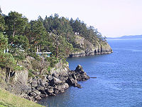
The Southern Gulf Islands are perhaps best known for their artists, wineries, fromageries, and farms, as well as for their natural beauty. Boating, kayaking, hiking, camping and wildlife viewing are all possible in the Southern Gulf Islands.
Northern Gulf Islands
The major Northern Gulf Islands, in alphabetical order, are:- Denman Island
- Hornby IslandHornby IslandHornby Island of British Columbia, Canada, is a Northern Gulf Island parallel with Vancouver Island's Comox Valley.A small community of 1,074 residents is distributed across the island. The island is culturally distinctive as it was the site of a large immigration of American draft dodgers during...
- Lasqueti IslandLasqueti IslandLasqueti Island is an island off the east coast of Vancouver Island in the Strait of Georgia, Powell River Regional District, British Columbia, Canada. A passenger-only ferry connects the island to the community of French Creek, near Parksville...
- Texada IslandTexada IslandTexada Island is the largest island in the Strait of Georgia of British Columbia, Canada. Its northern tip is located about southwest of the city of Powell River and west of the Sechelt Peninsula on the Sunshine Coast. A former mining and logging area, the island still has a few quarries and old...
Quadra Island
Quadra Island
Quadra Island is an island off the eastern coast of Vancouver Island, British Columbia, Canada, part of the Discovery Islands. It is separated from Vancouver Island by Discovery Passage, and from Cortes Island by Sutil Channel...
is sometimes said to be part of the Gulf Islands. It is more often designated as part of the Discovery Islands
Discovery Islands
The Discovery Islands are the islands in the Discovery Passage between Vancouver Island and the mainland in British Columbia. These islands are sometimes considered to be part of the Northern Gulf Islands....
.
"Gulf of Georgia"
The name "Gulf Islands" comes from "Gulf of Georgia," the original term used by George VancouverGeorge Vancouver
Captain George Vancouver RN was an English officer of the British Royal Navy, best known for his 1791-95 expedition, which explored and charted North America's northwestern Pacific Coast regions, including the coasts of contemporary Alaska, British Columbia, Washington and Oregon...
in his mapping of the southern part of the archipelago and which before the San Juan Island dispute also was taken to include what have since been called the San Juan Islands
San Juan Islands
The San Juan Islands are an archipelago in the northwest corner of the contiguous United States between the US mainland and Vancouver Island, British Columbia, Canada. The San Juan Islands are part of the U.S...
. Strictly speaking, the Strait of Georgia is only the wide, open waters of the main strait between the mainland and Vancouver Island, and does not officially refer to the adjoining waters between the islands and between them and Vancouver Island but has become a common misnomer for the entire Gulf, which includes waters such as Trincomali Channel
Trincomali Channel
Trincomali Channel is a channel or strait in the Gulf Islands of British Columbia, Canada, located between Saltspring Island and Galiano Island . It is named for HMS Trincomalee which was assigned to the Royal Navy's Pacific Station at Esquimalt in the 19th Century....
(between Galiano and Saltspring Islands), Sansum Narrows
Sansum Narrows
Sansum Narrows is a strait or channel between Vancouver Island and Saltspring Island in the Southern Gulf Islands region of British Columbia, Canada. It is crossed by a BC Ferries route from Crofton to Vesuvius Bay on the northwestern shore of Saltspring...
(between Saltspring Island
Saltspring Island
Saltspring Island is one of the Gulf Islands in the Strait of Georgia between mainland British Columbia, Canada and Vancouver Island. It is the largest, the most populous, and the most frequently visited of the Gulf Islands...
and Vancouver Island), and Malaspina Strait
Malaspina Strait
Malaspina Strait is a strait in the northern Gulf of Georgia-Sunshine Coast region of British Columbia, Canada. It separates Texada Island from the upper Sunshine Coast-Malaspina Peninsula area on the adjacent mainland....
(between Texada Island and the mainland around Powell River
Powell River, British Columbia
Powell River is a city on the northern Sunshine Coast of southwestern British Columbia, Canada. Most of its population lives near the eastern shores of Malaspina Strait, that part of the larger Georgia Strait between Texada Island and the Mainland...
. "The Gulf" refers to all such waters collectively, and to those communities and shores surrounding it. Only the term "Strait of Georgia" remains in the provincial gazette although its use as a synonym for the Gulf is unofficial, while the term Gulf of Georgia remains in current use though not in the provincial gazette.
The term Salish Sea
Salish Sea
The name Salish Sea was coined only in the late 20th century, and was officially recognized by the United States in 2009 and by Canada in 2010, to describe the coastal waterways surrounding southern Vancouver Island and Puget Sound between Canada and the United States of America...
was adopted in 2010 to refer to the Strait of Georgia, the Strait of Juan de Fuca
Strait of Juan de Fuca
The Strait of Juan de Fuca is a large body of water about long that is the Salish Sea outlet to the Pacific Ocean...
, Puget Sound
Puget Sound
Puget Sound is a sound in the U.S. state of Washington. It is a complex estuarine system of interconnected marine waterways and basins, with one major and one minor connection to the Strait of Juan de Fuca and the Pacific Ocean — Admiralty Inlet being the major connection and...
, and all connecting and adjoining waters.
Ecology
The islands and surrounding ocean are rich with ecologicallyEcology
Ecology is the scientific study of the relations that living organisms have with respect to each other and their natural environment. Variables of interest to ecologists include the composition, distribution, amount , number, and changing states of organisms within and among ecosystems...
diverse plants and sea life including Garry oak
Garry Oak
Quercus garryana, the Garry Oak, Oregon White Oak or Oregon Oak, has a range from southern California to extreme southwestern British Columbia, particularly southeastern Vancouver Island and the adjacent Gulf Islands. It grows from sea level to 210 m altitude in the northern part of its range, and...
s, wild lilies, kelp
Kelp
Kelps are large seaweeds belonging to the brown algae in the order Laminariales. There are about 30 different genera....
beds and Orca
Orca
The killer whale , commonly referred to as the orca, and less commonly as the blackfish, is a toothed whale belonging to the oceanic dolphin family. Killer whales are found in all oceans, from the frigid Arctic and Antarctic regions to tropical seas...
s. Gulf Islands National Park Reserve
Gulf Islands National Park Reserve
Gulf Islands National Park Reserve is the 40th National Park in a system of 43 parks and park reserves across Canada. Located in British Columbia's Gulf Islands, it covers 33 square kilometers over 16 islands. It also includes numerous islets and reef areas....
of Canada was established in 2003 by Parks Canada
Parks Canada
Parks Canada , also known as the Parks Canada Agency , is an agency of the Government of Canada mandated to protect and present nationally significant natural and cultural heritage, and foster public understanding, appreciation, and enjoyment in ways that ensure their ecological and commemorative...
to protect the area’s unique ecosystem.
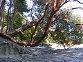
The Gulf Islands are home to one of the last remaining pockets of Garry oak
Garry Oak
Quercus garryana, the Garry Oak, Oregon White Oak or Oregon Oak, has a range from southern California to extreme southwestern British Columbia, particularly southeastern Vancouver Island and the adjacent Gulf Islands. It grows from sea level to 210 m altitude in the northern part of its range, and...
ecosystem
Ecosystem
An ecosystem is a biological environment consisting of all the organisms living in a particular area, as well as all the nonliving , physical components of the environment with which the organisms interact, such as air, soil, water and sunlight....
s. Only about five percent of Garry oak ecosystems remain in their natural state, landing 91 of the approximately 350 species
Species
In biology, a species is one of the basic units of biological classification and a taxonomic rank. A species is often defined as a group of organisms capable of interbreeding and producing fertile offspring. While in many cases this definition is adequate, more precise or differing measures are...
it supports on the province's list of species at risk. The unique Mediterranean characteristics of the islands' climate supports the Garry oak ecosystem. Garry oak ecosystems are home to more plant species, such as the camas
Camassia
Camassia is a genus of six species native to western North America, from southern British Columbia to northern California, and east to Utah, Wyoming and Montana...
, than any other terrestrial ecosystem in coastal B.C. and are one of Canada's most at-risk natural habitats.
Today, Garry oak meadows exist in the shallow and exposed soil
Soil
Soil is a natural body consisting of layers of mineral constituents of variable thicknesses, which differ from the parent materials in their morphological, physical, chemical, and mineralogical characteristics...
of valley
Valley
In geology, a valley or dale is a depression with predominant extent in one direction. A very deep river valley may be called a canyon or gorge.The terms U-shaped and V-shaped are descriptive terms of geography to characterize the form of valleys...
s, rocky foothills
Foothills
Foothills are geographically defined as gradual increases in elevation at the base of a mountain range. They are a transition zone between plains and low relief hills to the adjacent topographically high mountains.-Examples:...
and southern slopes — areas that the settlers of the past 150 years have found unsuitable for agriculture
Agriculture
Agriculture is the cultivation of animals, plants, fungi and other life forms for food, fiber, and other products used to sustain life. Agriculture was the key implement in the rise of sedentary human civilization, whereby farming of domesticated species created food surpluses that nurtured the...
or development
Subdivision (land)
Subdivision is the act of dividing land into pieces that are easier to sell or otherwise develop, usually via a plat. The former single piece as a whole is then known in the United States as a subdivision...
.
The Garry Oak Ecosystems Recovery Team (GOERT), a partnership of a number of governmental and non-governmental agencies that comprise 22 individuals, was established in 1999 after the delegates of the First International Garry Oak Ecosystem Symposium met in Victoria
Victoria, British Columbia
Victoria is the capital city of British Columbia, Canada and is located on the southern tip of Vancouver Island off Canada's Pacific coast. The city has a population of about 78,000 within the metropolitan area of Greater Victoria, which has a population of 360,063, the 15th most populous Canadian...
and declared the ecosystem endangered. Since then, GOERT has been working to motivate public and private restoration of the rare ecosystem and promote conservation
Habitat conservation
Habitat conservation is a land management practice that seeks to conserve, protect and restore, habitat areas for wild plants and animals, especially conservation reliant species, and prevent their extinction, fragmentation or reduction in range...
activities. http://www.canadiangeographic.ca/magazine/so06/indepth/nature.asp
Provincial Parks and Protected Areas
- Bellhouse Provincial ParkBellhouse Provincial ParkBellhouse Provincial Park is a provincial park in the southern Gulf Islands of British Columbia, Canada. It is located in the Sturdies Bay area of southeastern Galiano Island.-External links:...
, Galiano Island - Bodega Ridge Provincial ParkBodega Ridge Provincial ParkBodega Ridge Provincial Park is a provincial park in British Columbia, Canada. It is on Galiano Island and comprises 233 hectares...
, Galiano Island - Burgoyne Bay Provincial ParkBurgoyne Bay Provincial ParkBurgoyne Bay Provincial Park is a provincial park in British Columbia, Canada located on southwestern Saltspring Island near Fulford Harbour and facing northwest to Sansum Narrows, which is the channel between Saltspring and Vancouver Island. It is 334 hectares in size and was established via...
, Saltspring Island - Collinson Point Provincial ParkCollinson Point Provincial ParkCollinson Point Provincial Park is a provincial park on Galiano Island, British Columbia, Canada. It is located between Mount Galiano and the western approaches to Active Pass. The area is 24 hectares, with c. 500 metres of waterfront.-History:...
, Galiano Island - Dionisio Point Provincial ParkDionisio Point Provincial ParkDionisio Point Provincial Park is a provincial park in the southern Gulf Islands of British Columbia, Canada. It is located at the northwestern tip of Galiano Island, across Porlier Pass from Valdes Island.-External links:**...
, Galiano Island - Jedediah Island Marine Provincial ParkJedediah Island Marine Provincial ParkJedediah Island Marine Provincial Park is a provincial park in British Columbia, Canada. It is a small, island which is quite beautiful. Anyone is free to camp on Jedediah island; but usually the only way to get there is by boat. The nearest access is from Lasqueti Island.-The Palmers:The Palmers...
- Montague Harbour Marine Provincial ParkMontague Harbour Marine Provincial ParkMontague Harbour Marine Provincial Park is a provincial park in British Columbia, Canada, located on Galiano Island, one of the Gulf Islands off BC's South Coast in Canada. It is accessible by BC ferries from Swartz Bay on Vancouver Island or Tsawwassen on the Mainland...
, Galiano Island - Wakes Cove Provincial ParkWakes Cove Provincial ParkWakes Cove Provincial Park is a provincial park in the northeast corner of Valdes Island, located in the Gulf Islands in British Columbia, Canada. The park was created in June 2002. Currently the park has no facilities for overnight camping, and its intended use, as stated by BC parks, is...
Valdes Island
See also
- List of islands of Canada
- List of National Parks of Canada
- Southern Gulf Islands Electoral Area
External links
- Gulf Islands National Park Reserve — Parks Canada
- Come to the Islands Canadian GeographicCanadian GeographicCanadian Geographic is the bimonthly magazine of the Royal Canadian Geographical Society . It was first published in May 1930 under the name Canadian Geographical Journal. The society's objective was to produce a popular magazine dealing primarily with Canadian geography...
Special Feature on B.C.'s Gulf Islands - Southern Gulf Islands Atlas