

Keating Channel
Encyclopedia
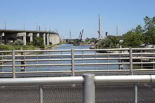
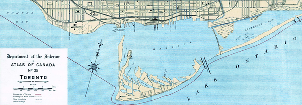
The Keating Channel is a short waterway in the inner harbour of Toronto, Ontario on Lake Ontario
Lake Ontario
Lake Ontario is one of the five Great Lakes of North America. It is bounded on the north and southwest by the Canadian province of Ontario, and on the south by the American state of New York. Ontario, Canada's most populous province, was named for the lake. In the Wyandot language, ontarío means...
. It connects the Don River
Don River (Toronto)
The Don River is one of two rivers bounding the original settled area of Toronto, Ontario along the shore of Lake Ontario, the other being the Humber River to the west. The Don is formed from two rivers, the East and West Branches, that meet about north of Lake Ontario while flowing southward into...
into Toronto Harbour
Toronto Harbour
Toronto Harbour or Toronto Bay is a bay on the north shore of Lake Ontario, in Toronto, Ontario, Canada. It is a natural harbour, protected from Lake Ontario waves by the Toronto Islands. It is a commercial port on the Great Lakes as well as a recreational harbour...
(Toronto Bay). The channel is named after Edward Henry Keating (1844-1912), a city engineer (1892-1898) who proposed the creation of the channel in 1893. The channel was originally built to connect Ashbridge's Bay to the harbour and the Don was later diverted into the channel, and its mouth filled in.
History
At the time Ashbridge's Bay was still a lacustrine
Lake
A lake is a body of relatively still fresh or salt water of considerable size, localized in a basin, that is surrounded by land. Lakes are inland and not part of the ocean and therefore are distinct from lagoons, and are larger and deeper than ponds. Lakes can be contrasted with rivers or streams,...
marsh
Marsh
In geography, a marsh, or morass, is a type of wetland that is subject to frequent or continuous flood. Typically the water is shallow and features grasses, rushes, reeds, typhas, sedges, other herbaceous plants, and moss....
. It was heavily polluted by local industry. The water from the river was diverted into the bay with the hope that it would flush the bay of the poor water. However the flow of water introduced raw sewage in the river into the bay. The bay water remained stagnant and was increasingly becoming a serious health risk. The Keating Channel was proposed as a method of directing the dirty river water into the harbour thus dispersing it more rapidly.
Initially the channel was planned to go from the northeast corner of the inner harbour east towards Leslie Street and join up with the Coatsworth Cut. However, the portion east of the Don River was never completed and it was closed in 1916. The channel was completed in 1922 after 8 years of construction. The completed channel now runs from the harbour east to the mouth of the river, a distance of about 800 metres.
The original mouth of the Don is now buried under infill near where the Gardiner Expressway
Gardiner Expressway
The Frederick G. Gardiner Expressway, colloquially referred to as "the Gardiner", is a municipal expressway in the Canadian province of Ontario, connecting downtown Toronto with its western suburbs...
meets Cherry Street. The original course from the mouth upstream now lies underneath railway tracks used by GO Transit
GO Transit
GO Transit is an inter-regional public transit system in Southern Ontario, Canada. It primarily serves the Greater Toronto and Hamilton Area conurbation, with operations extending to several communities beyond the GTHA proper in the Greater Golden Horseshoe...
for storage.
Today it is flanked on the north by the elevated Gardiner Expressway
Gardiner Expressway
The Frederick G. Gardiner Expressway, colloquially referred to as "the Gardiner", is a municipal expressway in the Canadian province of Ontario, connecting downtown Toronto with its western suburbs...
and Lake Shore Boulevard East. The south side is occupied by a city works yard and the Keating Channel Pub. At the west end Cherry Street crosses the channel over a single sided drawbridge
Drawbridge
A drawbridge is a type of movable bridge typically associated with the entrance of a castle surrounded by a moat. The term is often used to describe all different types of movable bridges, like bascule bridges and lift bridges.-Castle drawbridges:...
rarely used by ships. At the east end is the start of the Don Valley Parkway
Don Valley Parkway
The Don Valley Parkway is a controlled-access six-lane municipal expressway in Toronto connecting the Gardiner Expressway in downtown Toronto with Ontario Highway 401, the Macdonald–Cartier Freeway. North of Highway 401, it continues as Ontario Highway 404. The parkway runs through...
.
In the 1940s the watershed
Drainage basin
A drainage basin is an extent or an area of land where surface water from rain and melting snow or ice converges to a single point, usually the exit of the basin, where the waters join another waterbody, such as a river, lake, reservoir, estuary, wetland, sea, or ocean...
further up the Don River became more urbanized. This caused an increasing amount of silt
Silt
Silt is granular material of a size somewhere between sand and clay whose mineral origin is quartz and feldspar. Silt may occur as a soil or as suspended sediment in a surface water body...
to flow down the river. The silt ends up collecting in the channel where there is very little water flow. Since that time, the Toronto and Region Conservation Authority
Toronto and Region Conservation Authority
Toronto and Region Conservation Authority or Office de protection de la nature de Toronto et de la région is one of 36 conservation authorities in Ontario, Canada...
(TRCA) has been dredging the channel. The dredgeate material is barged out to the Leslie Street Spit
Leslie Street Spit
The Leslie Street Spit, or officially the Outer Harbour East Headland, is a man-made headland in Toronto, Ontario, extending from the city's east end in a roughly southwesterly direction into Lake Ontario. It is about 5 km long....
where it is dumped in a containment area specially built for this purpose. In 2005, the annual amount of silt dredged was about 35,000 cubic metres. The containment area has the capacity to take 50 years of Don River dredgeate http://www.trca.on.ca/water_protection/don_mouth/default.asp?load=key_study.
In 1980 Ontario's Minister of the Environment
Minister of the environment
An environment minister is a cabinet position in charged with protecting the natural environment and promoting wildlife conservation...
was asked, during question period
Question Period
Question Period, known officially as Oral Questions occurs each sitting day in the Canadian House of Commons. According to the House of Commons Compendium, “The primary purpose of Question Period is to seek information from the Government and to call it to account for its actions.”-History:The...
, about an exemption from environmental regulations, granted to those who dredged the channel.
Member of Provincial Parliament
Member of Provincial Parliament
A Member of Provincial Parliament is an elected member of the Legislative Assembly of the Province of Ontario, Canada.The titular designation "Member of Provincial Parliament" and the initialism "MPP" were formally adopted by the Legislature on April 7, 1938...
Bryden was quoting Donald Chant's recommendation concerning the Keating Channel, and why the recommendation had been ignored, when she was interrupted by the Minister. Chant was then the "chairman of the Premier
Premier
Premier is a title for the head of government in some countries and states.-Examples by country:In many nations, "premier" is used interchangeably with "prime minister"...
's steering committee on environmental assessment". According to the MPP Chant's recommendations had questioned whether dredging the channel was worthwhile:
Current issues
Riverdale Park (Toronto)
Riverdale Park is a large park spanning the Lower Don River, Toronto, Ontario, Canada between Cabbagetown to the west and Broadview Avenue in Riverdale to the east. Recreational fields for soccer, baseball, and Ultimate are available on both sides of the river with a swimming pool, tennis courts...
. In contrast the Humber River which has a natural mouth is home to about 44 species.
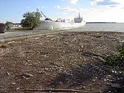
Another problem affecting the channel is floating debris that is washed down the Don. Mostly logs and dead wood, there is also an assortment of garbage that collects in the channel. The TRCA corrals this material with a boom across the channel. There can be quite a bit of flotsam especially after a big storm.
Restoration initiatives
On the north side of the channel a slight bend in Lake Shore Boulevard has created a narrow open space. The Task Force to Bring Back the DonTask Force to Bring Back the Don
The Task Force to Bring Back the Don is a citizen advisory committee that advises Toronto city council on issues concerning the Don River and its watershed. It consists of 20 citizen members and 3 council members.-History:...
decided to plant this area in 1998. They planted Staghorn Sumac
Rhus typhina
The Staghorn Sumac is a deciduous shrub to small tree in the Anacardiaceae or Cashew family, native to eastern North America...
(Rhus typhina), Sandbar Willow
Willow
Willows, sallows, and osiers form the genus Salix, around 400 species of deciduous trees and shrubs, found primarily on moist soils in cold and temperate regions of the Northern Hemisphere...
(Salix exigua), and Red Osier Dogwood
Red Osier Dogwood
The Red Osier Dogwood is a species of dogwood native throughout northern and western North America from Alaska east to Newfoundland, south to Durango and Nuevo León in the west, and Illinois and Virginia in the east...
(Cornus stolonifera). Despite poor soil conditions, the willow and the hardy sumac have thrived. These days it looks like a long narrow glade of small trees and shrubs, a small oasis amongst the blight of concrete and asphalt.
Another small green space at the eastern end was also planned for restoration but the project was abandoned after one planting. There was also a proposal to remove part of the dock wall to improve fish habitat. Both of these projects were suspended when it became apparent that a larger project would be starting soon.
In 1999, the three levels of government announced a large project to revitalize Toronto's waterfront
Toronto waterfront
The Toronto waterfront is the lakeshore of Lake Ontario in the City of Toronto, Ontario in Canada. It spans 46 kilometres between the mouth of Etobicoke Creek in the west, and the Rouge River in the East. The entire lakeshore has been significantly altered from its natural glaciated state prior to...
. Among the four initial projects was a plan to restore the mouth of the Don to a more natural outlet.
In 2005, an environmental assessment was initiated to investigate options to restore the original mouth of the Don. Some of the options being considered would fill in the Keating Channel and direct the Don River through a new channel just north of Lakeshore Boulevard or straight south to link up or cut the inner basin shipping channel to the south of the Keating Channel. The environmental assessment process is ongoing.
Proponents of restoring the mouth of the Don to a more natural state have argued that this restoration would ameliorate the damage expected from a rare flood with water-flow equal to or greater than that from 1954's Hurricane Hazel
Hurricane Hazel
Hurricane Hazel was the deadliest and costliest hurricane of the 1954 Atlantic hurricane season. The storm killed as many as 1,000 people in Haiti before striking the United States near the border between North and South Carolina, as a Category 4 hurricane...
.
External links
- Don Watershed Report Card
- Humber River Fish Inventory
- Toronto Port AuthorityToronto Port AuthorityThe Toronto Port Authority is a Canadian port authority responsible for management of the harbour of Toronto, Ontario, Canada, including the Billy Bishop Toronto City Airport...
archives, Toronto Harbour Commission BuildingToronto Harbour Commission BuildingThe Toronto Harbour Commission Building is a six storey building erected in 1917 in Toronto by Alfred Chapman for the locally run Toronto Harbour Commission. It is now home to the Toronto Port Authority, a federal agency... - Don Mouth Naturalization and Port Lands Flood Protection Project
- Google map of the Keating Channel
- Task Force to Bring Back the Don Vision for the mouth of the Don
- http://history.uwo.ca/cdneng/keating.html