
.gif)
Don River (Toronto)
Encyclopedia
The Don River is one of two rivers bounding the original settled area of Toronto
, Ontario
along the shore of Lake Ontario
, the other being the Humber River to the west. The Don is formed from two rivers, the East and West Branches, that meet about 7 kilometres (4 mi) north of Lake Ontario
while flowing southward into the lake. The area below the confluence is known as the lower Don, and the areas above as the upper Don. The Don is also joined at the confluence by a third major branch, Taylor-Massey Creek
. The Toronto and Region Conservation Authority
(TRCA) is responsible for managing the river and its surrounding watershed.
most likely as nomadic hunters. While there is little archaeological evidence in the Don valley itself, regional finds in the Great Lakes St. Lawrence area have revealed that permanent settlements started to occur about 6000 BP. The most significant recorded find is known as the Withrow Site. It was discovered in 1886 during road building just east of Riverdale Park
. It contained human remains and other artifacts dating back to about 5000 years BP.
It is unclear whether the Don River had a native Canadian name. In 1788, Alexander Aitkin
, an English surveyor who worked in southern Ontario, referred to the Don River as Ne cheng qua kekonk. Elizabeth Simcoe
, wife of Lieutenant Governor John Graves Simcoe
, reported in her diary that another name used was Wonscotanach. This is an Anishnaabe phrase meaning black burnt grounds which could refer to an earlier forest fire. The Don River was named by J.G. Simcoe because the wide valley reminded him of the River Don in Yorkshire.
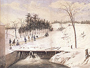
After the founding of York
in 1793, several mills were constructed along the lower Don. One of the first was at Todmorden Mills
. These mills initially turned out lumber, flour and paper products. By the 1850s, the Lower Don was becoming an industrial setting. Petroleum storage facilities, poultry and pork
processing plants were constructed along the banks of the Don. In 1879, the Don Valley Brick Works opened. Polluted effluent from these factories and the growing city nearby was turning the Don and its marshy mouth into a polluted hazard.
 In the 1880s the lower part of the Don south of the former Winchester St. bridge was straightened (east of the original mouth) and placed in a channel to create additional harbour space and industrial dock space for boats. Known as Don Improvement Project, the straightened river was also supposed to divert the polluted waters into the Ashbridges Bay marsh. This proved unsuccessful so the mouth was turned 90 degrees west where it empties into the inner harbour. This short extension of the harbour is known as the Keating Channel
. The channel north of Lake Shore Blvd. East ceased being navigable when the Gardiner Expressway
was constructed in the 1950s. Boats may still enter the Keating Channel by going underneath a lift bridge at Cherry St.
During the early part of the 20th century the river and the valley continued to be neglected. 31 separate sewage treatment facilities were built along the river. Over 20 places in the valley and adjacent ravines were used as landfills for garbage and industrial refuse. In 1917, the Don Destructor was built beside the Don just north of Dundas Ave. East. It was used as a garbage incinerator for 52 years burning about 50,000 tonnes per year.
After World War II, rapid urban expansion occurred in the northern reaches of the watershed. In 1954, Hurricane Hazel
struck the Toronto area. Intensive flooding affected the lower reaches. Flood waters affected downtown Toronto as far east as Leslie Street and as far west as Bay Street. While no loss of life occurred in the Don Watershed the result of this storm was that the TRCA was given a mandate to construct flood control features as well as acquire property in the Don Valley as well as along its major tributaries. Large tracts of industrial land adjacent to the river were added to the regulatory floodplain. This meant that the TRCA had a veto on any developments that were not floodproofed.
 In the early 1960s, the Don Valley Parkway
(DVP) was constructed through the Lower Don to serve the growing commuter traffic. The increasing development reduced the natural areas of the watershed. This impacted the Don with increased pollution, heavy flooding, and turbid sediment laden waters. The combined result meant that by the 1960s the river was a neglected, polluted mess. In 1969, Pollution Probe held a much celebrated “Funeral for the Don” to highlight the plight of the river.
Efforts to restore the Don gathered steam in 1989 with a public forum at the Ontario Science Centre which was attended by about 500 people. The result was the formation of the Task Force to Bring Back the Don
, a citizen’s advisory body to Toronto City Council. Their mandate and vision was to make the Don “clean, green, and accessible”. Since then they have hosted garbage cleanups, tree plantings, and help to create or restore eight wetlands in the lower reaches of the valley, including Chester Springs Marsh, a 3 ha site south of the Bloor Viaduct. Other groups also became active including Friends of the Don East
. The TRCA created the Don Watershed Regeneration Council to coordinate restoration efforts throughout the watershed.
In 1991 Bring Back the Don released a document called “Bringing Back the Don” which laid out plans for restoration, including a renaturalized mouth of the Don. In 1998 a plan to revive Toronto’s waterfront was initiated. One of the four projects mentioned was a natural mouth for the Don River. In 2001 an environmental assessment was started to look into a natural mouth of the Don. The project was also coupled with a plan to handle a major flood modelled on the expected output from a Hurricane Hazel size storm. In 2007, the Toronto Waterfront Development Corporation (now WaterfrontToronto) held a design competition that looked at four different configurations for the mouth of the Don. The winning bid was made by Michael Van Valkenburgh Associates
. The environmental assessment is expected to be complete in 2008 and construction is scheduled to begin in 2010.
, a glacier lake which was the precursor to Lake Ontario. The Don River is now small in comparison to the deep and wide valley that resulted from its glacial origin. The Don River is now classified as an underfit river
.
The landscape at that time was loose glacial till so the large amounts of glacier melt water eroded deep valleys over thousands of years. As time progressed, isostatic uplift caused the earth's plate to rise and tilt. This caused Lake Iroquois to drain towards the south. A remnant of its shoreline can be seen on the north side of Davenport Road in Toronto. In the Don Valley, the old shoreline is evident just north of Eglinton Avenue
. Today the source of the Don River is the Oak Ridges Moraine
, another legacy of the Wisconsin glaciation.
The location of the old shoreline is important when considering soils in the Don watershed. Soils north of the old shoreline are mostly luvisolic Halton Till while south of the shoreline they are still sandy glaciolacustrine deposits.
The Don Valley contains one of the most interesting locations for studying the regional geological history. The Don Valley Brick Works
was an old brick making factory with a quarry where they extracted shale. At the rear wall, local geologists discovered a record of the past three glaciations. There are nine distinct layers visible dating back 120,000 years.
style flood have been estimated at nearly 1700 m3/s. On August 19, 2005, an unusually strong summer storm
caused short term flooding in the Don Valley. Peak flow rates for that event were measured at 55.3 m3/s. Since high flow rates occur during storm events, the resulting floods tend to scour the bottom of the river which reduces fish habitat. In addition, the flood waters carry a large amount of sediment washed into the river from surrounding tablelands. The sediment collects in the Keating Channel
just past the mouth of the river. The TRCA which is responsible for the dredging estimates that the amount of sediment dredged is 35,000 m3/year weighing nearly 60,000 tonnes.
, flowing south-eastward through ravine forests in Richmond Hill
, Thornhill
, east of Willowdale and Don Mills. A second branch of the eastern Don, known as German Mills Creek
, parallels the main eastern branch and joins it at Steeles Avenue, the northern boundary of Toronto. South of Lawrence Avenue the river passes through the Charles Sauriol Conservation Reserve. This area is mostly undeveloped parkland. The reserve occupies the valley south to the forks of the Don. It was at one time home of a Maple sugar
shack and tapline, which was visited yearly by students from across East York
. Charles Sauriol
was a historic protector of the Don.
The western branch starts near Maple, Ontario
, flowing south-east through the suburban industrial belt of Concord
(Vaughan
), and the G. Ross Lord Reservoir. It crosses Yonge Street as it flows through Hoggs Hollow, past York University
's Glendon
("valley of the Don") campus, and then flows on to Leaside
before joining the eastern half.
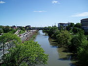
Downstream from the forks, the river flows through a wooded area known as Crothers' Woods
which is designated as an Environmentally Sensitive Area due to the high quality beech-maple forest
that grows on the ravine slopes. South of Pottery Road it enters a more degraded section and ends up in a straightened section that includes cement and steel dock wall, a remnant from an earlier industrial era. The river flows unceremoniously into the Keating Channel
at Lake Shore Boulevard East which is at the north east corner of the Toronto Harbour
.
The western section of Taylor-Massey Creek and the southern portion of the western branch are surrounded by parkland (see also: Toronto ravine system
). In more recent years the retreat of the industrial plants and rail infrastructure has freed up room which is now being turned into bicycling trails, which now extend from the shore of Lake Ontario northward in several directions to provide some 30 km of off-road paved trails. While Toronto is fairly flat in general, local cyclists have developed a number of technically challenging singletrack trails throughout the area, following the main trails.
Toronto
Toronto is the provincial capital of Ontario and the largest city in Canada. It is located in Southern Ontario on the northwestern shore of Lake Ontario. A relatively modern city, Toronto's history dates back to the late-18th century, when its land was first purchased by the British monarchy from...
, Ontario
Ontario
Ontario is a province of Canada, located in east-central Canada. It is Canada's most populous province and second largest in total area. It is home to the nation's most populous city, Toronto, and the nation's capital, Ottawa....
along the shore of Lake Ontario
Lake Ontario
Lake Ontario is one of the five Great Lakes of North America. It is bounded on the north and southwest by the Canadian province of Ontario, and on the south by the American state of New York. Ontario, Canada's most populous province, was named for the lake. In the Wyandot language, ontarío means...
, the other being the Humber River to the west. The Don is formed from two rivers, the East and West Branches, that meet about 7 kilometres (4 mi) north of Lake Ontario
Lake Ontario
Lake Ontario is one of the five Great Lakes of North America. It is bounded on the north and southwest by the Canadian province of Ontario, and on the south by the American state of New York. Ontario, Canada's most populous province, was named for the lake. In the Wyandot language, ontarío means...
while flowing southward into the lake. The area below the confluence is known as the lower Don, and the areas above as the upper Don. The Don is also joined at the confluence by a third major branch, Taylor-Massey Creek
Taylor-Massey Creek (Don)
Taylor-Massey Creek is a tributary of the Don River in Toronto, Ontario. It flows through Scarborough and East York, where it enters the Don River. The creek is named after two prominent Toronto families. The Taylors were a wealthy family that owned and operated the Don Valley Brick Works...
. The Toronto and Region Conservation Authority
Toronto and Region Conservation Authority
Toronto and Region Conservation Authority or Office de protection de la nature de Toronto et de la région is one of 36 conservation authorities in Ontario, Canada...
(TRCA) is responsible for managing the river and its surrounding watershed.
History
Humans first arrived in the Don approximately 12,500 years BPBefore Present
Before Present years is a time scale used in archaeology, geology, and other scientific disciplines to specify when events in the past occurred. Because the "present" time changes, standard practice is to use AD 1950 as the origin of the age scale, reflecting the fact that radiocarbon...
most likely as nomadic hunters. While there is little archaeological evidence in the Don valley itself, regional finds in the Great Lakes St. Lawrence area have revealed that permanent settlements started to occur about 6000 BP. The most significant recorded find is known as the Withrow Site. It was discovered in 1886 during road building just east of Riverdale Park
Riverdale Park (Toronto)
Riverdale Park is a large park spanning the Lower Don River, Toronto, Ontario, Canada between Cabbagetown to the west and Broadview Avenue in Riverdale to the east. Recreational fields for soccer, baseball, and Ultimate are available on both sides of the river with a swimming pool, tennis courts...
. It contained human remains and other artifacts dating back to about 5000 years BP.
It is unclear whether the Don River had a native Canadian name. In 1788, Alexander Aitkin
Alexander Aitkin
Sir Alexander Aitkin was deputy surveyor general and later the first surveyor general of Upper Canada.He was responsible for surveying and creating the first city plan for Toronto and made plans for the York Harbour in 1793....
, an English surveyor who worked in southern Ontario, referred to the Don River as Ne cheng qua kekonk. Elizabeth Simcoe
Elizabeth Simcoe
Elizabeth Simcoe was an artist and diarist in colonial Canada. She was the wife of John Graves Simcoe, the first Lieutenant Governor of Upper Canada.-Biography:...
, wife of Lieutenant Governor John Graves Simcoe
John Graves Simcoe
John Graves Simcoe was a British army officer and the first Lieutenant Governor of Upper Canada from 1791–1796. Then frontier, this was modern-day southern Ontario and the watersheds of Georgian Bay and Lake Superior...
, reported in her diary that another name used was Wonscotanach. This is an Anishnaabe phrase meaning black burnt grounds which could refer to an earlier forest fire. The Don River was named by J.G. Simcoe because the wide valley reminded him of the River Don in Yorkshire.
After the founding of York
York, Upper Canada
York was the name of Old Toronto between 1793 and 1834. It was the second capital of Upper Canada.- History :The town was established in 1793 by Governor John Graves Simcoe, with a new 'Fort York' on the site of the last French 'Fort Toronto'...
in 1793, several mills were constructed along the lower Don. One of the first was at Todmorden Mills
Todmorden Mills
Todmorden Mills was a small settlement located in the Don River valley in Toronto, Ontario. It started out as a lumber mill in the 1790s. Originally known as "Don Mills", it grew into a small industrial complex and village before becoming part of East York in the 20th century...
. These mills initially turned out lumber, flour and paper products. By the 1850s, the Lower Don was becoming an industrial setting. Petroleum storage facilities, poultry and pork
William Davies Company
William Davies Company was a pork processing and packing company in Toronto, Canada. At one time, it was the largest pork packer both in Canada and the British Empire, and it operated Canada's first major chain of food stores...
processing plants were constructed along the banks of the Don. In 1879, the Don Valley Brick Works opened. Polluted effluent from these factories and the growing city nearby was turning the Don and its marshy mouth into a polluted hazard.
Keating Channel
The Keating Channel is a short waterway in the inner harbour of Toronto, Ontario on Lake Ontario. It connects the Don River into Toronto Harbour . The channel is named after Edward Henry Keating , a city engineer who proposed the creation of the channel in 1893...
. The channel north of Lake Shore Blvd. East ceased being navigable when the Gardiner Expressway
Gardiner Expressway
The Frederick G. Gardiner Expressway, colloquially referred to as "the Gardiner", is a municipal expressway in the Canadian province of Ontario, connecting downtown Toronto with its western suburbs...
was constructed in the 1950s. Boats may still enter the Keating Channel by going underneath a lift bridge at Cherry St.
During the early part of the 20th century the river and the valley continued to be neglected. 31 separate sewage treatment facilities were built along the river. Over 20 places in the valley and adjacent ravines were used as landfills for garbage and industrial refuse. In 1917, the Don Destructor was built beside the Don just north of Dundas Ave. East. It was used as a garbage incinerator for 52 years burning about 50,000 tonnes per year.
After World War II, rapid urban expansion occurred in the northern reaches of the watershed. In 1954, Hurricane Hazel
Hurricane Hazel
Hurricane Hazel was the deadliest and costliest hurricane of the 1954 Atlantic hurricane season. The storm killed as many as 1,000 people in Haiti before striking the United States near the border between North and South Carolina, as a Category 4 hurricane...
struck the Toronto area. Intensive flooding affected the lower reaches. Flood waters affected downtown Toronto as far east as Leslie Street and as far west as Bay Street. While no loss of life occurred in the Don Watershed the result of this storm was that the TRCA was given a mandate to construct flood control features as well as acquire property in the Don Valley as well as along its major tributaries. Large tracts of industrial land adjacent to the river were added to the regulatory floodplain. This meant that the TRCA had a veto on any developments that were not floodproofed.
Don Valley Parkway
The Don Valley Parkway is a controlled-access six-lane municipal expressway in Toronto connecting the Gardiner Expressway in downtown Toronto with Ontario Highway 401, the Macdonald–Cartier Freeway. North of Highway 401, it continues as Ontario Highway 404. The parkway runs through...
(DVP) was constructed through the Lower Don to serve the growing commuter traffic. The increasing development reduced the natural areas of the watershed. This impacted the Don with increased pollution, heavy flooding, and turbid sediment laden waters. The combined result meant that by the 1960s the river was a neglected, polluted mess. In 1969, Pollution Probe held a much celebrated “Funeral for the Don” to highlight the plight of the river.
Efforts to restore the Don gathered steam in 1989 with a public forum at the Ontario Science Centre which was attended by about 500 people. The result was the formation of the Task Force to Bring Back the Don
Task Force to Bring Back the Don
The Task Force to Bring Back the Don is a citizen advisory committee that advises Toronto city council on issues concerning the Don River and its watershed. It consists of 20 citizen members and 3 council members.-History:...
, a citizen’s advisory body to Toronto City Council. Their mandate and vision was to make the Don “clean, green, and accessible”. Since then they have hosted garbage cleanups, tree plantings, and help to create or restore eight wetlands in the lower reaches of the valley, including Chester Springs Marsh, a 3 ha site south of the Bloor Viaduct. Other groups also became active including Friends of the Don East
Friends of the Don East
Friends of the Don East is an Canadian non-governmental organization based in Toronto, Ontario. They are an environmental group whose goal is to preserve and protect natural areas in the Don River watershed.-History:...
. The TRCA created the Don Watershed Regeneration Council to coordinate restoration efforts throughout the watershed.
In 1991 Bring Back the Don released a document called “Bringing Back the Don” which laid out plans for restoration, including a renaturalized mouth of the Don. In 1998 a plan to revive Toronto’s waterfront was initiated. One of the four projects mentioned was a natural mouth for the Don River. In 2001 an environmental assessment was started to look into a natural mouth of the Don. The project was also coupled with a plan to handle a major flood modelled on the expected output from a Hurricane Hazel size storm. In 2007, the Toronto Waterfront Development Corporation (now WaterfrontToronto) held a design competition that looked at four different configurations for the mouth of the Don. The winning bid was made by Michael Van Valkenburgh Associates
Michael Van Valkenburgh
Michael R. Van Valkenburgh is an American landscape architect and educator. He has worked on a wide variety of projects in the United States, Canada, Korea, and France including public parks, college campuses, sculpture gardens, city courtyards, corporate landscapes, and private gardens-Early...
. The environmental assessment is expected to be complete in 2008 and construction is scheduled to begin in 2010.
Geology
The Don Valley is notable because of its deep wide valley in the lower reaches. At the Bloor Street Viaduct, the valley is about 400 m wide while the river is only about 15 m wide. This is due to its glacial origins. The Don River and its deep valley were formed about 12,000 years ago at the end of the Wisconsinan Glaciation. During that glaciation which lasted for 35,000 years, all of Ontario was covered in ice. As the climate warmed the glaciers began to melt. As the ice front retreated in southern Ontario, several rivers were formed that drained into Lake IroquoisGlacial Lake Iroquois
Glacial Lake Iroquois was a prehistoric proglacial lake that existed at the end of the last ice age approximately 13,000 years ago.The lake was essentially an enlargement of the present Lake Ontario that formed because the St. Lawrence River downstream from the lake was blocked by the ice sheet...
, a glacier lake which was the precursor to Lake Ontario. The Don River is now small in comparison to the deep and wide valley that resulted from its glacial origin. The Don River is now classified as an underfit river
Misfit stream
A misfit stream is a stream that is far too small to have eroded the valley which the stream occupies. The shape of the valley may also be inconsistent with a typical valley that has been eroded by water. Generally it is reasonable to expect a valley to be in proportion with the stream that...
.
The landscape at that time was loose glacial till so the large amounts of glacier melt water eroded deep valleys over thousands of years. As time progressed, isostatic uplift caused the earth's plate to rise and tilt. This caused Lake Iroquois to drain towards the south. A remnant of its shoreline can be seen on the north side of Davenport Road in Toronto. In the Don Valley, the old shoreline is evident just north of Eglinton Avenue
Eglinton Avenue
Eglinton Avenue, originally known as the Richview Sideroad within Etobicoke, is an east-west arterial thoroughfare in Toronto and Mississauga, in the Canadian province of Ontario. Within Toronto, Eglinton Avenue is the only road which crosses through all six former boroughs...
. Today the source of the Don River is the Oak Ridges Moraine
Oak Ridges Moraine
The Oak Ridges Moraine is an ecologically important geological landform in the Mixedwood Plains of south-central Ontario, Canada. The moraine covers a geographic area of between Caledon and Rice Lake, near Peterborough...
, another legacy of the Wisconsin glaciation.
The location of the old shoreline is important when considering soils in the Don watershed. Soils north of the old shoreline are mostly luvisolic Halton Till while south of the shoreline they are still sandy glaciolacustrine deposits.
The Don Valley contains one of the most interesting locations for studying the regional geological history. The Don Valley Brick Works
Don Valley Brick Works
The Don Valley Brick Works also known as Evergreen Brickworks is a former quarry and industrial site located in the Don River valley in Toronto, Ontario. Currently the buildings sit mostly unused while the quarry has been converted into a city park which includes a series of naturalized ponds...
was an old brick making factory with a quarry where they extracted shale. At the rear wall, local geologists discovered a record of the past three glaciations. There are nine distinct layers visible dating back 120,000 years.
Hydrology
Due to the urbanized nature of the watershed, the Don River experiences low base flows interspersed with high volume floods. The water level can rise very quickly following a moderate to heavy rainfall, up to 1–2 metres inside of three hours. The average base flow for the Don River is about 4 m3/s. Peak flows occur in late February and late September which corresponds to seasonal variation in the Toronto region. Maximum flows, based on a Hurricane HazelHurricane Hazel
Hurricane Hazel was the deadliest and costliest hurricane of the 1954 Atlantic hurricane season. The storm killed as many as 1,000 people in Haiti before striking the United States near the border between North and South Carolina, as a Category 4 hurricane...
style flood have been estimated at nearly 1700 m3/s. On August 19, 2005, an unusually strong summer storm
Southern Ontario Tornado Outbreak of 2005
The Southern Ontario Tornado Outbreak of 2005 in a series of thunderstorms on the afternoon of August 19, 2005, spawned tornadoes damaging homes in the Conestoga Lake, Fergus, and Tavistock areas. A tornado was reported within the Toronto city limits, although this was never officially confirmed by...
caused short term flooding in the Don Valley. Peak flow rates for that event were measured at 55.3 m3/s. Since high flow rates occur during storm events, the resulting floods tend to scour the bottom of the river which reduces fish habitat. In addition, the flood waters carry a large amount of sediment washed into the river from surrounding tablelands. The sediment collects in the Keating Channel
Keating Channel
The Keating Channel is a short waterway in the inner harbour of Toronto, Ontario on Lake Ontario. It connects the Don River into Toronto Harbour . The channel is named after Edward Henry Keating , a city engineer who proposed the creation of the channel in 1893...
just past the mouth of the river. The TRCA which is responsible for the dredging estimates that the amount of sediment dredged is 35,000 m3/year weighing nearly 60,000 tonnes.
Physical description
The east branch of the Don, also called the Little Don River, rises at the south edge of the Oak Ridges Moraine just to the west of Yonge StreetYonge Street
Yonge Street is a major arterial route connecting the shores of Lake Ontario in Toronto to Lake Simcoe, a gateway to the Upper Great Lakes. It was formerly listed in the Guinness Book of Records as the longest street in the world at , and the construction of Yonge Street is designated an "Event of...
, flowing south-eastward through ravine forests in Richmond Hill
Richmond Hill, Ontario
Richmond Hill is a town located in Southern Ontario, Canada in the central portion of York Region, Ontario. It is part of the Greater Toronto Area, being located about halfway between Toronto and Lake Simcoe...
, Thornhill
Thornhill, Ontario
Thornhill is a community in the Greater Toronto Area of Southern Ontario, Canada, located on the northern border of the city of Toronto. Once a municipal village, Thornhill is now a community and postal designation geographically split into two municipalities along Yonge Street, the city of...
, east of Willowdale and Don Mills. A second branch of the eastern Don, known as German Mills Creek
German Mills Creek (Don)
German Mills Creek is a tributary of the Don River. It originates in Richmond Hill , flows south through Markham and empties into the Don River East Branch just south of Steeles Avenue near Leslie Street...
, parallels the main eastern branch and joins it at Steeles Avenue, the northern boundary of Toronto. South of Lawrence Avenue the river passes through the Charles Sauriol Conservation Reserve. This area is mostly undeveloped parkland. The reserve occupies the valley south to the forks of the Don. It was at one time home of a Maple sugar
Maple sugar
Maple sugar is a traditional sweetener in the northeastern United States and Canada, prepared from the sap of the sugar maple tree.-Preparation:...
shack and tapline, which was visited yearly by students from across East York
East York
East York can refer to:*East York, Pennsylvania, United States*East York, Ontario, Canada...
. Charles Sauriol
Charles Sauriol
Charles Joseph Sauriol, CM was a Canadian naturalist who was responsible for the preservation of many natural areas in Ontario and across Canada.-Early life:...
was a historic protector of the Don.
The western branch starts near Maple, Ontario
Maple, Ontario
Maple is a high-growth suburban community northwest of Toronto, Ontario, Canada, part of the city of Vaughan in York Region.-Geography:The west branch of the Don River rises to the northwest and flows 1 km west of Maple. Several creeks are to the east and the Black Creek begins slightly west...
, flowing south-east through the suburban industrial belt of Concord
Concord, Ontario
Concord is an unincorporated suburban industrial community in the City of Vaughan in York Region, located north of Toronto, Ontario, Canada. According to the 2001 Census, the community has 8,255 residents ....
(Vaughan
Vaughan, Ontario
Vaughan is a city in York Region north of Toronto, Ontario, Canada. Vaughan is the fastest growing municipality in Canada achieving a population growth rate of 80.2% between 1996–2006, according to Statistics Canada having nearly doubled in population since 1991. Vaughan is located in Southern...
), and the G. Ross Lord Reservoir. It crosses Yonge Street as it flows through Hoggs Hollow, past York University
York University
York University is a public research university in Toronto, Ontario, Canada. It is Canada's third-largest university, Ontario's second-largest graduate school, and Canada's leading interdisciplinary university....
's Glendon
Glendon College
Glendon College is one of the two campuses of York University, Canada's third-largest university, in Toronto, Ontario. A bilingual liberal arts college with 84 full-time faculty members and a student population of about 2400, Glendon is located in midtown Toronto's Lawrence Park neighbourhood...
("valley of the Don") campus, and then flows on to Leaside
Leaside
Leaside is a neighbourhood in Toronto, Ontario, Canada. The area takes its name from William Lea and the Lea family, who settled there in the early years of the nineteenth century. The area first developed as farmland along with Toronto through the nineteenth century. It was incorporated as a...
before joining the eastern half.
Downstream from the forks, the river flows through a wooded area known as Crothers' Woods
Crothers' Woods
Crothers' Woods is an area of the Don River valley in Toronto, Ontario, Canada. It is approximately 25 ha in size and consists of woodland, meadows, wetlands, and an assortment of past and present municipal uses. The wooded area has been designated as an Environmentally Significant Area by the...
which is designated as an Environmentally Sensitive Area due to the high quality beech-maple forest
Beech-maple forest
A beech-maple forest is a climax mesic closed canopy hardwood forest. It is primarily composed of American Beech and Sugar Maple trees which co-dominate the forest and which are the pinnacle of plant succession in their range...
that grows on the ravine slopes. South of Pottery Road it enters a more degraded section and ends up in a straightened section that includes cement and steel dock wall, a remnant from an earlier industrial era. The river flows unceremoniously into the Keating Channel
Keating Channel
The Keating Channel is a short waterway in the inner harbour of Toronto, Ontario on Lake Ontario. It connects the Don River into Toronto Harbour . The channel is named after Edward Henry Keating , a city engineer who proposed the creation of the channel in 1893...
at Lake Shore Boulevard East which is at the north east corner of the Toronto Harbour
Toronto Harbour
Toronto Harbour or Toronto Bay is a bay on the north shore of Lake Ontario, in Toronto, Ontario, Canada. It is a natural harbour, protected from Lake Ontario waves by the Toronto Islands. It is a commercial port on the Great Lakes as well as a recreational harbour...
.
The western section of Taylor-Massey Creek and the southern portion of the western branch are surrounded by parkland (see also: Toronto ravine system
Toronto ravine system
The Toronto ravine system is one of the most distinctive features of the geography of Toronto, Ontario, Canada. It is a network of deep ravines that form a large urban forest that runs throughout much of the city...
). In more recent years the retreat of the industrial plants and rail infrastructure has freed up room which is now being turned into bicycling trails, which now extend from the shore of Lake Ontario northward in several directions to provide some 30 km of off-road paved trails. While Toronto is fairly flat in general, local cyclists have developed a number of technically challenging singletrack trails throughout the area, following the main trails.
See also
External links
- Don River Watershed at the Toronto and Region Conservation AuthorityToronto and Region Conservation AuthorityToronto and Region Conservation Authority or Office de protection de la nature de Toronto et de la région is one of 36 conservation authorities in Ontario, Canada...
- Environment Canada (Toronto Remedial Action Plan) Great Lakes Portrait: Bringing back the Don River
- Task Force to Bring back the Don
- Don Watershed Regeneration
- Lower Don River at Lost River Walks
- Friends of the Don East
- Todmorden Mills Wildflower Preserve in the Don River Valley