

Timeline of the 2009 Atlantic hurricane season
Encyclopedia
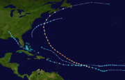
2009 Atlantic hurricane season
The 2009 Atlantic hurricane season was a below-average year, unlike the 2009 Pacific hurricane season, which was above average, both due to a moderate El Niño. During this year, nine tropical storms formed, the fewest since the 1997 season.An average season has ten tropical storms, six hurricanes...
was a below-average year in which nine tropical storms formed, the fewest since 1997
1997 Atlantic hurricane season
The 1997 Atlantic hurricane season is the most recent Atlantic hurricane season to feature no tropical cyclones in August. The season officially began on June 1, 1997, and lasted until November 30, 1997...
.An average season has eleven tropical storms, six hurricanes and two major hurricanes. Although Tropical Depression One
Tropical Depression One (2009)
Tropical Depression One was the first tropical cyclone to develop during the 2009 Atlantic hurricane season. Upon being declared a tropical depression on May 28, it marked the third time that a pre-season storm formed in three consecutive years...
formed on May 28, 2009, the season officially began on June 1 and ended on November 30. The season's last storm, Hurricane Ida
Hurricane Ida (2009)
Hurricane Ida was the strongest landfalling tropical cyclone during the 2009 Atlantic hurricane season, crossing the coastline of Nicaragua with winds of 80 mph . The remnants of the storm became a powerful nor'easter that caused widespread damage along coastal areas of the Mid-Atlantic States...
, dissipated on November 11.
The season had eleven tropical depressions, of which nine intensified into tropical storms, three became hurricanes, and two became major hurricanes.A major hurricane is a storm that ranks as Category 3 or higher on the Saffir-Simpson Hurricane Scale
Saffir-Simpson Hurricane Scale
The Saffir–Simpson Hurricane Scale , or the Saffir–Simpson Hurricane Wind Scale , classifies hurricanes — Western Hemisphere tropical cyclones that exceed the intensities of tropical depressions and tropical storms — into five categories distinguished by the intensities of their sustained winds...
. The inactivity throughout the basin was linked to the formation of an El Niño, which increased wind shear
Wind shear
Wind shear, sometimes referred to as windshear or wind gradient, is a difference in wind speed and direction over a relatively short distance in the atmosphere...
. The two most significant storms of the season, in terms of loss of life and damage, were Hurricanes Bill
Hurricane Bill (2009)
Hurricane Bill was a relatively large Atlantic tropical cyclone, attaining a maximum gale-diameter of 460 mi . A Cape Verde type hurricane, Bill originated from a tropical wave that emerged from the western coast of Africa on August 12, and organized into a tropical depression near the Cape...
and Ida. Hurricane Bill was an unusually large storm and was also the season's strongest, attaining winds of 135 mph (215 km/h). Tropical Storm Claudette was the only storm during 2009 to make landfall
Landfall (meteorology)
Landfall is the event of a tropical cyclone or a waterspout coming onto land after being over water. When a waterspout makes landfall it is reclassified as a tornado, which can then cause damage inland...
in the United States; Hurricane Ida became extratropical shortly before coming ashore in Alabama
Alabama
Alabama is a state located in the southeastern region of the United States. It is bordered by Tennessee to the north, Georgia to the east, Florida and the Gulf of Mexico to the south, and Mississippi to the west. Alabama ranks 30th in total land area and ranks second in the size of its inland...
.
This timeline includes information that was not operationally released, meaning that information from post-storm reviews by the National Hurricane Center
National Hurricane Center
The National Hurricane Center , located at Florida International University in Miami, Florida, is the division of the National Weather Service responsible for tracking and predicting weather systems within the tropics between the Prime Meridian and the 140th meridian west poleward to the 30th...
, such as a storm that was not operationally warned upon, has been included. This timeline documents tropical cyclone
Tropical cyclone
A tropical cyclone is a storm system characterized by a large low-pressure center and numerous thunderstorms that produce strong winds and heavy rain. Tropical cyclones strengthen when water evaporated from the ocean is released as the saturated air rises, resulting in condensation of water vapor...
formations, strengthening, weakening, landfalls, extratropical transitions, and dissipations during the season.
May
- 1 a.m. EDT (0600 UTCCoordinated Universal TimeCoordinated Universal Time is the primary time standard by which the world regulates clocks and time. It is one of several closely related successors to Greenwich Mean Time. Computer servers, online services and other entities that rely on having a universally accepted time use UTC for that purpose...
) – Tropical Depression OneTropical Depression One (2009)Tropical Depression One was the first tropical cyclone to develop during the 2009 Atlantic hurricane season. Upon being declared a tropical depression on May 28, it marked the third time that a pre-season storm formed in three consecutive years...
develops from an area of low pressureLow pressure areaA low-pressure area, or "low", is a region where the atmospheric pressure at sea level is below that of surrounding locations. Low-pressure systems form under areas of wind divergence which occur in upper levels of the troposphere. The formation process of a low-pressure area is known as...
roughly 175 mi (280 km)The figures for maximum sustained windMaximum sustained windThe maximum sustained winds associated with a tropical cyclone are a common indicator of the intensity of the storm. Within a mature tropical cyclone, they are found within the eyewall at a distance defined as the radius of maximum wind, or RMW. Unlike gusts, the value of these winds are...
s and position estimates are rounded to the nearest 5 units (knots, miles, or kilometers), following the convention used in the National Hurricane CenterNational Hurricane CenterThe National Hurricane Center , located at Florida International University in Miami, Florida, is the division of the National Weather Service responsible for tracking and predicting weather systems within the tropics between the Prime Meridian and the 140th meridian west poleward to the 30th...
's operational products for each storm. All other units are rounded to the nearest digit. east-northeast of Cape Hatteras, North Carolina. - 1 p.m. EDT (1800 UTC) – Tropical Depression One attains its peak intensity with winds of 35 mph (55 km/h) and a barometric pressure of 1006 mbarBar (unit)The bar is a unit of pressure equal to 100 kilopascals, and roughly equal to the atmospheric pressure on Earth at sea level. Other units derived from the bar are the megabar , kilobar , decibar , centibar , and millibar...
(hPaPascal (unit)The pascal is the SI derived unit of pressure, internal pressure, stress, Young's modulus and tensile strength, named after the French mathematician, physicist, inventor, writer, and philosopher Blaise Pascal. It is a measure of force per unit area, defined as one newton per square metre...
; 29.71 inHg).
May 29
- 7 p.m. EDT (0000 UTC on May 30) – Tropical Depression One degenerates into a non-convectiveAtmospheric convectionAtmospheric convection is the result of a parcel-environment instability, or temperature difference, layer in the atmosphere. Different lapse rates within dry and moist air lead to instability. Mixing of air during the day which expands the height of the planetary boundary layer leads to...
remnant low pressure areaLow pressure areaA low-pressure area, or "low", is a region where the atmospheric pressure at sea level is below that of surrounding locations. Low-pressure systems form under areas of wind divergence which occur in upper levels of the troposphere. The formation process of a low-pressure area is known as...
roughly 345 mi (555 km) south-southeast of Halifax, Nova Scotia.
June
- No tropical cyclones formed during the month of June.
June 1
- 12 a.m. EDT (0400 UTC) – The 2009 Atlantic hurricane season officially begins.
July
- No tropical cyclones formed during the month of July, making the 2009 season one of fourteen since 1944 in which no tropical storms developed during June and July.
August
- 2:00 a.m. ASTUTC-4UTC−04-00 is an identifier for a time offset from UTC of −04.This offset is used in the Atlantic Standard Time Zone in Canada and the North American Eastern Time Zone during daylight saving time , in the Caribbean region this is considered as the Eastern Caribbean timezone...
(0600 UTC) – Tropical Depression Two develops from a tropical waveTropical waveTropical waves, easterly waves, or tropical easterly waves, also known as African easterly waves in the Atlantic region, are a type of atmospheric trough, an elongated area of relatively low air pressure, oriented north to south, which move from east to west across the tropics causing areas of...
roughly 230 mi (370 km) west of the Cape Verde Islands.
August 12
- 8:00 a.m. AST (1200 UTC) – Post-season research indicated that at this time, Tropical Depression Two attained tropical storm status. However, as it was not operationally recognized as such, it was not named.
- 8:00 p.m. AST (0000 UTC on August 13) – Tropical Storm Ana weakens into a tropical depression.
August 13
- 2:00 a.m. AST (0600 UTC) – Tropical Depression Two degenerates into an non-convective remnant low about 775 mi (1,250 km) west of the Cape Verde Islands.
August 14
- 8:00 p.m. AST (0000 UTC on August 15) – The remnants of Tropical Depression Two regenerate into a tropical depression roughly 1,075 mi (1,730 km) east of the Lesser AntillesLesser AntillesThe Lesser Antilles are a long, partly volcanic island arc in the Western Hemisphere. Most of its islands form the eastern boundary of the Caribbean Sea with the Atlantic Ocean, with the remainder located in the southern Caribbean just north of South America...
.
August 15
- 2:00 a.m. AST (0600 UTC) – Tropical Depression Two strengthens into Tropical Storm AnaTropical Storm Ana (2009)Tropical Storm Ana was the first named storm of the 2009 Atlantic hurricane season and the first tropical cyclone to impact the Caribbean islands during 2009. Forming out of an area of low pressure associated with a tropical wave on August 11, Ana briefly attained tropical storm intensity on...
. The storm also attains its peak intensity with winds of 40 mph (65 km/h) and a minimum pressure of 1003 mbar (hPa; 29.62 inHg). - 2:00 a.m. AST (0600 UTC) – Tropical Depression Three forms out of a tropical wave roughly 380 mi (610 km) west-southwest of the Cape Verde islands.
- 2:00 p.m. AST (1800 UTC) – Tropical Depression Three strengthens into Tropical Storm BillHurricane Bill (2009)Hurricane Bill was a relatively large Atlantic tropical cyclone, attaining a maximum gale-diameter of 460 mi . A Cape Verde type hurricane, Bill originated from a tropical wave that emerged from the western coast of Africa on August 12, and organized into a tropical depression near the Cape...
.
August 16
- 1:00 a.m. EDT (0600 UTC) – Tropical Depression Four develops over the eastern Gulf of MexicoGulf of MexicoThe Gulf of Mexico is a partially landlocked ocean basin largely surrounded by the North American continent and the island of Cuba. It is bounded on the northeast, north and northwest by the Gulf Coast of the United States, on the southwest and south by Mexico, and on the southeast by Cuba. In...
, roughly 60 mi (95 km) west-southwest of Sarasota, FloridaSarasota, FloridaSarasota is a city located in Sarasota County on the southwestern coast of the U.S. state of Florida. It is south of the Tampa Bay Area and north of Fort Myers...
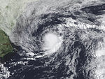
. - 7:00 a.m. EDT (1200 UTC) – Tropical Depression Four strengthens into Tropical Storm ClaudetteTropical Storm Claudette (2009)Tropical Storm Claudette was the third named storm of the 2009 Atlantic hurricane season and the first tropical cyclone of 2009 to affect the United States. Forming out of a tropical wave and an upper-level low pressure system on August 16, Claudette quickly intensified into a tropical storm...
. - 8:00 a.m. AST (1200 UTC) – Tropical Storm Ana weakens into a tropical depression shortly before degenerating into a troughTrough (meteorology)A trough is an elongated region of relatively low atmospheric pressure, often associated with fronts.Unlike fronts, there is not a universal symbol for a trough on a weather chart. The weather charts in some countries or regions mark troughs by a line. In the United States, a trough may be marked...
of low pressure roughly 400 mi (645 km) east of the Lesser Antilles. - 1:00 p.m. EDT (1800 UTC) – Tropical Storm Claudette attains its peak winds of 60 mph (95 km/h) while situated roughly 40 mi (65 km) south of Apalachicola, FloridaApalachicola, FloridaApalachicola is a city in Franklin County, Florida, on US 98 about southwest of Tallahassee. The population was 2,334 at the 2000 census. The 2005 census estimated the city's population at 2,340...
. - 7:00 p.m. EDT (0000 UTC on August 17) – Tropical Storm Claudette attains its minimum pressure of 1005 mbar (hPa; 29.68 inHg) just off the FloridaFloridaFlorida is a state in the southeastern United States, located on the nation's Atlantic and Gulf coasts. It is bordered to the west by the Gulf of Mexico, to the north by Alabama and Georgia and to the east by the Atlantic Ocean. With a population of 18,801,310 as measured by the 2010 census, it...
coastline.
August 17
- 12:30 a.m. EDT (0530 UTC) – Tropical Storm Claudette makes landfall near Fort Walton Beach, FloridaFort Walton Beach, FloridaFort Walton Beach is a city in southern Okaloosa County, Florida, United States. As of 2005, the population estimate for Fort Walton Beach was 19,992, and as of 2010, the population estimate for Fort Walton Beach is 19,507 recorded by the U.S. Census Bureau...
with winds of 45 mph (75 km/h). - 2:00 a.m. AST (0600 UTC) – Tropical Storm Bill strengthens into a Category 1 hurricane midway between the Lesser Antilles and the Cape Verde Islands.
- 7:00 a.m. EDT (1200 UTC) – Tropical Storm Claudette weakens to a tropical depression over AlabamaAlabamaAlabama is a state located in the southeastern region of the United States. It is bordered by Tennessee to the north, Georgia to the east, Florida and the Gulf of Mexico to the south, and Mississippi to the west. Alabama ranks 30th in total land area and ranks second in the size of its inland...
. - 7:00 p.m. EDT (0000 UTC on August 18) – Tropical Depression Claudette dissipates over eastern MississippiMississippiMississippi is a U.S. state located in the Southern United States. Jackson is the state capital and largest city. The name of the state derives from the Mississippi River, which flows along its western boundary, whose name comes from the Ojibwe word misi-ziibi...
. - 8:00 p.m. AST (0000 UTC on August 18) – Hurricane BillHurricane Bill (2009)Hurricane Bill was a relatively large Atlantic tropical cyclone, attaining a maximum gale-diameter of 460 mi . A Cape Verde type hurricane, Bill originated from a tropical wave that emerged from the western coast of Africa on August 12, and organized into a tropical depression near the Cape...
strengthens to a Category 2 hurricane.
August 18
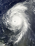
- 2:00 p.m. AST (1800 UTC) – Hurricane Bill strengthens into a major hurricane—a storm with winds of 111 mph (178 km/h) or higher.
August 19
- 2:00 a.m. AST (0600 UTC) – Hurricane Bill strengthens to a Category 4 hurricane, attaining its peak winds of 135 mph (215 km/h).
August 20
- 8:00 a.m. AST (1200 UTC) – Hurricane Bill weakens to a Category 3 hurricane.
- 8:00 a.m. AST (0000 UTC on August 21) – Hurricane Bill attains its secondary peak intensity with winds of 125 mph (205 km/h) and a minimum pressure of 943 mbar (hPa; 27.84 inHg), the lowest pressure recorded in any storm during the 2009 season.
August 21
- 2:00 p.m. AST (1800 UTC) – Hurricane Bill weakens to a Category 2 hurricane.
August 22
- 2:00 a.m. AST (0600 UTC) – Hurricane Bill makes its closest approach to BermudaBermudaBermuda is a British overseas territory in the North Atlantic Ocean. Located off the east coast of the United States, its nearest landmass is Cape Hatteras, North Carolina, about to the west-northwest. It is about south of Halifax, Nova Scotia, Canada, and northeast of Miami, Florida...
, passing roughly 175 mi (280 km) west of the island with winds of 105 mph (165 km/h). - 2:00 p.m. AST (1800 UTC) – Hurricane Bill weakens to a Category 1 hurricane.
August 23
- 2:00 p.m. AST (1800 UTC) – Hurricane Bill brushes the coastline of Nova ScotiaNova ScotiaNova Scotia is one of Canada's three Maritime provinces and is the most populous province in Atlantic Canada. The name of the province is Latin for "New Scotland," but "Nova Scotia" is the recognized, English-language name of the province. The provincial capital is Halifax. Nova Scotia is the...
with winds of 80 mph (130 km/h). - 10:00 p.m. AST (0200 UTC on August 24) – Hurricane Bill weakens to a tropical storm just off the southern coast of Newfoundland
- 11:00 a.m. AST (0300 UTC) – Tropical Storm Bill makes landfall at Point Rosie on the Burin PeninsulaBurin PeninsulaThe Burin Peninsula is a Canadian peninsula located on the south coast of the island of Newfoundland in the province of Newfoundland and Labrador....
of Newfoundland with winds of 70 mph (110 km/h).
August 24
- 8:00 a.m. AST (1200 UTC) – Tropical Storm Bill transitions into an extratropical cycloneExtratropical cycloneExtratropical cyclones, sometimes called mid-latitude cyclones or wave cyclones, are a group of cyclones defined as synoptic scale low pressure weather systems that occur in the middle latitudes of the Earth having neither tropical nor polar characteristics, and are connected with fronts and...
over the north Atlantic Ocean as it rapidly tracks eastward towards the United KingdomUnited KingdomThe United Kingdom of Great Britain and Northern IrelandIn the United Kingdom and Dependencies, other languages have been officially recognised as legitimate autochthonous languages under the European Charter for Regional or Minority Languages...
.
August 26
- 4:00 a.m. EDT (0900 UTC) – Tropical Storm DannyTropical Storm Danny (2009)Tropical Storm Danny was a weak and disorganized tropical cyclone that formed in August 2009. The fourth tropical system and third named storm of the 2009 Atlantic hurricane season, Danny developed on August 26 from the interaction between a westward-moving tropical wave and an upper-level trough...
develops from a disorganized area of low pressure roughly 495 mi (795 km) east of Nassau, BahamasNassau, BahamasNassau is the capital, largest city, and commercial centre of the Commonwealth of the Bahamas. The city has a population of 248,948 , 70 percent of the entire population of The Bahamas...
. - 7:00 p.m. EDT (0000 UTC on August 27) – Tropical Storm Danny attains its peak intensity with winds of 60 mph (95 km/h) and a minimum pressure of 1006 mbar (hPa; 29.71 inHg).
August 29
- 1:00 a.m. EDT (0600 UTC) – Tropical Storm Danny degenerates into a trough of low pressure shortly before being absorbed by a larger low pressure system.
September
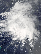
September 1- 2:00 p.m. AST (1800 UTC) – Tropical Storm ErikaTropical Storm Erika (2009)Tropical Storm Erika was a short-lived tropical cyclone that had minor impacts in the Lesser Antilles. The fifth named storm of the 2009 Atlantic hurricane season, Erika originated out of a tropical wave on September 1 near the Lesser Antilles. Although it was a disorganized system, it was...
forms roughly 290 mi (465 km) east of GuadeloupeGuadeloupeGuadeloupe is an archipelago located in the Leeward Islands, in the Lesser Antilles, with a land area of 1,628 square kilometres and a population of 400,000. It is the first overseas region of France, consisting of a single overseas department. As with the other overseas departments, Guadeloupe...
. - 8:00 p.m. AST (0000 UTC on September 2) – Tropical Storm Erika attains its peak intensity with winds of 50 mph (85 km/h) and a minimum pressure of 1004 mbar (hPa; 29.65 inHg).
September 2
- 2:30 p.m. AST (1830 UTC) – Tropical Storm Erika passes over the island of Guadeloupe with winds of 40 mph (65 km/h).
September 3
- 2:00 p.m. AST (1800 UTC) – Tropical Storm Erika weakens to a tropical depression.
- 8:00 p.m. AST (0000 UTC on September 4) – Tropical Depression Erika degenerates into a non-covective remnant low over the eastern Caribbean SeaCaribbean SeaThe Caribbean Sea is a sea of the Atlantic Ocean located in the tropics of the Western hemisphere. It is bounded by Mexico and Central America to the west and southwest, to the north by the Greater Antilles, and to the east by the Lesser Antilles....
.
September 7
- 2:00 p.m. AST (1800 UTC) – Tropical Depression Seven develops out of an area of low pressure roughly 220 mi (355 km) south of Brava, Cape VerdeBrava, Cape VerdeBrava is an island in Cape Verde. It is the smallest inhabited island, but at the same time the greenest, of Cape Verde, in the Sotavento group. First settled in the 1540s, its population grew after Mount Fogo on neighbouring Fogo erupted in 1675...
. - 8:00 p.m. AST (0000 UTC on September 8) – Tropical Depression Seven intensifies into Tropical Storm Fred.
September 8
- 8:00 p.m. AST (0000 UTC on September 9) – Tropical Storm Fred intensifies into a hurricane, the second of the season.
September 9
- 2:00 a.m. AST (0600 UTC) – Hurricane FredHurricane Fred (2009)Hurricane Fred was one of the easternmost forming major hurricanes in the North Atlantic basin on record. Forming out of a strong tropical wave on September 7 near the Cape Verde Islands, Fred gradually organized within an area of moderate wind shear. The following day, decreasing shear...
intensifies into a Category 2 hurricane. - 8:00 a.m. AST (1200 UTC) – Hurricane Fred further intensifies into a Category 3 hurricane and attains its peak intensity with winds of 120 mph (195 km/h) and a minimum pressure of 958 mbar (hPa; 28.29 inHg), becoming the strongest known hurricane on record south of 30°N and east of 35°W.
- 8:00 p.m. AST (0000 UTC on September 10) – Hurricane Fred weakens to a Category 2 hurricane.
September 10
- 2:00 p.m. AST (1800 UTC) – Hurricane Fred weakens to a Category 1 hurricane.
September 11
- 2:00 p.m. AST (1800 UTC) – Hurricane Fred weakens to a tropical storm as it stalls northwest of the Cape Verde Islands.
September 12
- 2:00 p.m. AST (1800 UTC) – Tropical Storm Fred degenerates into a non-convective remnant low roughly 570 mi (920 km) west of Santo Antão, Cape Verde. The remnants of Fred would persist for nearly a week before fully dissipating south of Bermuda on September 19.
September 25
- 2:00 p.m. AST (1800 UTC) – Tropical Depression Eight forms roughly 225 mi (360 km) southwest of the Cape Verde Islands.
September 26
- 2:00 p.m. AST (1800 UTC) – Tropical Depression Eight degenerates into a remnant low west of the Cape Verde Islands.
October
October 4- 2:00 a.m. AST (0600 UTC) – Tropical Storm GraceTropical Storm Grace (2009)Tropical Storm Grace holds the record for being the farthest northeast forming tropical cyclone in the Atlantic basin. The seventh named storm of the slightly below average 2009 Atlantic hurricane season, Grace formed from an extratropical cyclone over the Azores on October 4...
forms out of an extratropical system roughly 135 mi (225 km) west of Lajes, Azores, becoming the northeasternmost forming cyclone in the Atlantic on record. - 8:00 p.m. AST (0000 UTC on October 5) – Tropical Storm Grace attains its peak winds of 65 mph (100 km/h).
October 5
- 2:00 p.m. AST (1800 UTC) – Tropical Storm Grace attains its minimum pressure of 986 mbar (hPa; 29.11 inHg).
- 8:00 p.m. AST (0000 UTC on October 6) – The tenth tropical depression of the season forms roughly 775 mi (1,250 km) east of the Lesser Antilles.
October 6
- 2:00 a.m. AST (0600 UTC) – Tropical Storm Grace transitions into an extratropical cyclone roughly 230 mi (370 km) west-southwest of Cork, IrelandCork (city)Cork is the second largest city in the Republic of Ireland and the island of Ireland's third most populous city. It is the principal city and administrative centre of County Cork and the largest city in the province of Munster. Cork has a population of 119,418, while the addition of the suburban...
. - 2:00 a.m. AST (0600 UTC) – The tropical depression east of the Lesser Antilles strengthens into Tropical Storm Henri.
October 7
- 2:00 a.m. AST (0600 UTC) – Tropical Storm Henri attains its peak intensity with winds of 50 mph (85 km/h) and a minimum pressure of 1005 mbar (hPa; 29.68 inHg).
October 8
- 2:00 a.m. AST (0600 UTC) – Tropical Storm Henri weakens to a tropical depression.
- 2:00 p.m. AST (1800 UTC) – Tropical Depression Henri degenerates into a remnant low roughly 155 mi (250 km) north of AnguillaAnguillaAnguilla is a British overseas territory and overseas territory of the European Union in the Caribbean. It is one of the most northerly of the Leeward Islands in the Lesser Antilles, lying east of Puerto Rico and the Virgin Islands and directly north of Saint Martin...
.
November
November 4- 12:00 a.m. CDT (0600 UTC) – Tropical Depression Eleven forms over the southwestern Caribbean Sea near San Andres Island.
- 6:00 a.m. CDT (1200 UTC) – Tropical Depression Eleven intensifies into Tropical Storm Ida.
November 5
- 12:00 a.m. CDT (0600 UTC) – Tropical Storm Ida strengthens into a Category 1 hurricane as it passes near the Corn IslandsCorn IslandsThe Corn Islands are two islands about east off the Caribbean coast of Nicaragua, constituting one of 12 municipalities of the Región Autónoma del Atlántico Sur department...
with winds of 75 mph (120 km/h). - 6:00 a.m. CDT (1200 UTC) – Hurricane IdaHurricane Ida (2009)Hurricane Ida was the strongest landfalling tropical cyclone during the 2009 Atlantic hurricane season, crossing the coastline of Nicaragua with winds of 80 mph . The remnants of the storm became a powerful nor'easter that caused widespread damage along coastal areas of the Mid-Atlantic States...
makes landfall near Rio Grande, NicaraguaLa Cruz de Río GrandeLa Cruz de Río Grande is a municipality in the RAAS department of Nicaragua. According to the 2005 census, the population of La Cruz de Rio Grande was 3,000. It gets its name from the Rio Grande de Matagalpa which flows through it....
with winds of 80 mph (130 km/h). - 12:00 p.m. CDT (1800 UTC) – Hurricane Ida weakens into a tropical storm over the high terrain of Nicaragua.
November 6
- 12:00 a.m. CDT (0600 UTC) – Tropical Storm Ida further weakens to a tropical depression as it nears HondurasHondurasHonduras is a republic in Central America. It was previously known as Spanish Honduras to differentiate it from British Honduras, which became the modern-day state of Belize...
.
November 7
- 12:00 a.m. CDT (0600 UTC) – Tropical Depression Ida restrengthens into a tropical storm after moving over the warm waters of the northwestern Caribbean Sea.
- 6:00 p.m. CDT (0000 UTC on November 8) – Tropical Storm Ida regains hurricane status.
November 8
- 6:00 a.m. CDT (1200 UTC) – Hurricane Ida intensifies into a Category 2 hurricane.
- 12:00 p.m. CDT (1800 UTC) – Hurricane Ida attains its minimum pressure of 975 mbar (hPa; 28.79 inHg).
- 6:00 p.m. CDT (0000 UTC on November 9) – Hurricane Ida attains its peak winds of 105 mph (165 km/h) over the Yucatan ChannelYucatán ChannelThe Yucatán Channel is a strait between Mexico and Cuba. It connects the Yucatán Basin of the Caribbean Sea with the Gulf of Mexico. The strait is across between Cape Catoche in Mexico and Cape San Antonio, Cuba and reaches a maximum depth of .-References:...
.
November 9
- 12:00 a.m. CDT (0600 UTC) – Hurricane Ida weakens to a Category 1 hurricane.
- 6:00 a.m. CDT (1200 UTC) – Hurricane Ida quickly weakens to a tropical storm.
- 12:00 p.m. CDT (1800 UTC) – Tropical Storm Ida regains hurricane status for a third time.
- 3:00 p.m. CDT (2100 UTC) – Hurricane Ida attains its secondary peak intensity with winds of 85 mph (140 km/h).
- 6:00 p.m. CDT (0000 UTC) – Hurricane Ida weakens to a tropical storm as it nears the United States Gulf Coast.
November 10
- 3:00 a.m. CDT (0900 UTC) – Tropical Storm Ida transitions into an extratropical cyclone just before moving inland over southern Alabama.
November 30
- The 2009 Atlantic hurricane season officially ends.
See also
- List of Atlantic hurricanes
- Timeline of the 2009 Pacific hurricane seasonTimeline of the 2009 Pacific hurricane seasonBelow is the Timeline of the 2009 Pacific hurricane season, documenting all the storm formations, strengthening, weakening, landfalls, extratropical transitions, as well as dissipation. The 2009 Pacific hurricane season officially began on May 15, 2009, and will last until November 30. For...