

Timeline of the 2009 Pacific hurricane season
Encyclopedia
Landfall (meteorology)
Landfall is the event of a tropical cyclone or a waterspout coming onto land after being over water. When a waterspout makes landfall it is reclassified as a tornado, which can then cause damage inland...
, extratropical transitions, as well as dissipation. The 2009 Pacific hurricane season
2009 Pacific hurricane season
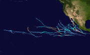
The 2009 Pacific hurricane season was an active event in the annual cycle of tropical cyclone formation, due to a moderate El Niño, unlike the 2009 Atlantic hurricane season, which was relatively quiet. The season officially started on May 15 in the eastern Pacific, and on June 1 for the central...
officially began on May 15, 2009, and will last until November 30. For convenience and clarity, in the timeline below, all landfalls are bolded. The timeline will also include information, when it becomes available, which was not operationally released, meaning that information from post-storm reviews by the National Hurricane Center
National Hurricane Center
The National Hurricane Center , located at Florida International University in Miami, Florida, is the division of the National Weather Service responsible for tracking and predicting weather systems within the tropics between the Prime Meridian and the 140th meridian west poleward to the 30th...
, such as information on a storm that was not operationally warned on, have been included.
The graphical bar below gives a brief overview of storm activity during the season, and for convenience, the storm's maximum intensity is included as a color bar.
May
May 15- 0000 UTC (5:00 p.m. PDT May 14) – The 2009 Eastern Pacific hurricane season officially begins.
- No tropical cyclones formed during the month of May, making 2009 the first time that no tropical cyclones formed during May since 1999.
June
June 1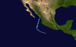
- 0000 UTC (11:00 p.m. May 31HST) – The 2009 Central Pacific hurricane season officially begins.
June 18
- 1200 UTC (5:00 pm PDT) – Tropical Depression One-ETropical Depression One-E (2009)Tropical Depression One-E was the earliest known tropical cyclone to impact the Mexican state of Sinaloa. The first system of the 2009 Pacific hurricane season, One-E formed out of an area of disturbed weather on June 18, 2009, and initially tracked slowly northwards...
forms about 405 mi (650 km) south-southwest of MazatlánMazatlánMazatlán is a city in the Mexican state of Sinaloa; the surrounding municipio for which the city serves as the municipal seat is Mazatlán Municipality. It is located at on the Pacific coast, across from the southernmost tip of the Baja California peninsula.Mazatlán is a Nahuatl word meaning...
, SinaloaSinaloaSinaloa officially Estado Libre y Soberano de Sinaloa is one of the 31 states which, with the Federal District, comprise the 32 Federal Entities of Mexico. It is divided in 18 municipalities and its capital city is Culiacán Rosales....
.
June 19
- 0000 UTC (5:00 pm PDT June 18) – Tropical Depression One-E attains its peak intensity of 35 mph (55 km/h) and a barometric pressure of 1003 mbarBar (unit)The bar is a unit of pressure equal to 100 kilopascals, and roughly equal to the atmospheric pressure on Earth at sea level. Other units derived from the bar are the megabar , kilobar , decibar , centibar , and millibar...
(hPaPascal (unit)The pascal is the SI derived unit of pressure, internal pressure, stress, Young's modulus and tensile strength, named after the French mathematician, physicist, inventor, writer, and philosopher Blaise Pascal. It is a measure of force per unit area, defined as one newton per square metre...
; 29.62 inHg). - 1800 UTC (11:00 pm PDT) – Tropical Depression One-E degenerates into a trough of low pressureTrough (meteorology)A trough is an elongated region of relatively low atmospheric pressure, often associated with fronts.Unlike fronts, there is not a universal symbol for a trough on a weather chart. The weather charts in some countries or regions mark troughs by a line. In the United States, a trough may be marked...
near the Mexican coastline.
June 21
- 1200 UTC (11:00 a.m. PDT) – Tropical Depression Two-E forms about 165 mi (265 km) southeast of AcapulcoAcapulcoAcapulco is a city, municipality and major sea port in the state of Guerrero on the Pacific coast of Mexico, southwest from Mexico City. Acapulco is located on a deep, semi-circular bay and has been a port since the early colonial period of Mexico’s history...
, Mexico. - 1800 UTC (5:00 p.m. PDT) – Tropical Depression Two-E strengthens into Tropical Storm Andres.
June 23
- 0600 UTC (5:00 a.m. PDT) – Tropical Storm Andres intensifies into a Category 1 hurricane, with winds peaking at 80 mph (130 km/h), the first of the season while located 80 mi (130 km) southwest of Lazaro Cardenas, Mexico.
June 24
- 0000 UTC (5:00 a.m. PDT) – Hurricane Andres weakens to a tropical storm.
- 1200 UTC (5:00 p.m. PDT) – Tropical Storm Andres weakens to a tropical depression.
- 1800 UTC (11:00 p.m. PDT) – Tropical Depression Andres is downgraded trough of low pressureTrough (meteorology)A trough is an elongated region of relatively low atmospheric pressure, often associated with fronts.Unlike fronts, there is not a universal symbol for a trough on a weather chart. The weather charts in some countries or regions mark troughs by a line. In the United States, a trough may be marked...
shortly before dissipating.
July
July 6- 0600 UTC (11:00 p.m. PDT July 5) – A tropcial depression forms forms about 440 mi (708.1 km) south of Cabo San LucasCabo San LucasCabo San Lucas , commonly called Cabo, is a city at the southern tip of the Baja California peninsula, in the municipality of Los Cabos in the Mexican state of Baja California Sur. As of the 2010 census, the population was 68,463 people...
, MexicoMexicoThe United Mexican States , commonly known as Mexico , is a federal constitutional republic in North America. It is bordered on the north by the United States; on the south and west by the Pacific Ocean; on the southeast by Guatemala, Belize, and the Caribbean Sea; and on the east by the Gulf of...
. - 1200 UTC (5:00 a.m. PDT) – The tropical Depression is upgraded to Tropical Storm Blanca.
July 8
- 1200 UTC (5:00 a.m. PDT) – Tropical Storm Blanca weakens back to a tropical depression.
July 9
- 0600 UTC (11:00 p.m. PDT July 8) – Tropical Depression Blanca weakens into a remnant low about 795 mi (1,279.4 km) west of Cabo San Lucas, Mexico.
July 10
- 0600 UTC (11:00 p.m. PDT July 9) – Tropical Depression Four-E forms about 900 mi (1,448.4 km) south of the southern tip of Baja CaliforniaBaja California SurBaja California Sur , is one of the 31 states which, with the Federal District, comprise the 32 Federal Entities of Mexico. Before becoming a state on October 8, 1974, the area was known as the South Territory of Baja California. It has an area of , or 3.57% of the land mass of Mexico and comprises...
. - 1800 UTC (11:00 a.m. PDT) – Tropical Depression Four-E strengthens into Tropical Storm Carlos.
July 11
- 1800 UTC (11:00 a.m. PDT) – Tropical Storm Carlos strengthens into Hurricane Carlos.
July 13
- 0000 UTC (5:00 p.m. PDT July 12) – Hurricane Carlos weakens to a tropical storm.
July 14
- 1200 UTC (5:00 a.m. PDT) – Tropical Storm Carlos re-strengthens back into a Category 1 hurricane.
July 15
- 0000 UTC (5:00 p.m. PDT July 14) – Hurricane Carlos reaches Category 2 intensity.
- 0000 UTC (5:00 p.m. PDT July 14) – Tropical Depression Five-E forms 795 mi (1,279.4 km) west-southwest of Manzanillo, Mexico.
- 1200 UTC (5:00 a.m. PDT) – Tropical Depression Five-E strengthens into Tropical Storm Dolores.
- 1800 UTC (11:00 a.m. PDT) – Hurricane Carlos is downgraded to a tropical storm.
July 16
- 0600 UTC (11:00 p.m. PDT July 15) – Tropical Storm Carlos weakens to a tropical depression.
- 1800 UTC (11:00 a.m. PDT) – Tropical Storm Dolores degenerates into a remnant low.
July 17
- 0000 UTC (5:00 p.m. PDT July 16) – Tropical Depression Carlos dissipates.
July 30
- 1200 UTC (8:00 a.m. PDT) – Tropical Depression Six-E forms 1185 mi (1,907.1 km) east-southeast of Hilo, Hawaii.
- 1800 UTC (8:00 a.m. HST) – Tropical Depression Six-E enters the Central Pacific Hurricane CenterCentral Pacific Hurricane CenterThe Central Pacific Hurricane Center of the United States National Weather Service is the official body responsible for tracking and issuing tropical cyclone warnings, watches, advisories, discussions, and statements for the Central North Pacific Basin...
's area of responsibility and is upgraded to Tropical Storm Lana 1075 mi (1,730 km) east-southeast of Hilo, Hawaii.
August
August 2- 1800 UTC (8:00 a.m. HST) – Tropical Storm Lana weakens to a tropical depression.
August 3
- 0000 UTC (2:00 p.m. HST August 2) – Tropical Depression Lana degenerates into a remnant low.
- 1800 UTC (11:00 a.m. PDT) – Tropical Depression Seven-E forms 670 mi (1,078.3 km) southwest of Manzanillo, Mexico.
- 1800 UTC (11:00 a.m. PDT) – Tropical Depression Eight-E forms.
August 4
- 0000 UTC (5:00 p.m. August 3 PDT) – Tropical Depression Seven-E strengthens into Tropical Storm Enrique.
- 0000 UTC (5:00 p.m. August 3 PDT) – Tropical Depression Eight-E is upgraded to Tropical Storm Felicia 1140 mi (1,834.6 km) southwest of the southern tip of Baja CaliforniaBaja CaliforniaBaja California officially Estado Libre y Soberano de Baja California is one of the 31 states which, with the Federal District, comprise the 32 Federal Entities of Mexico. It is both the northernmost and westernmost state of Mexico. Before becoming a state in 1953, the area was known as the North...
. - 1800 UTC (11:00 a.m. PDT) - Tropical Storm Felicia is upgraded to Hurricane FeliciaHurricane Felicia (2009)Hurricane Felicia was the third strongest tropical cyclone of the 2009 Pacific hurricane season, as well as the strongest storm to exist in the eastern Pacific at the time since Hurricane Daniel in 2006. Forming as a tropical depression on August 3, the storm supported strong thunderstorm...
.
August 5
- 0600 UTC (11:00 p.m. PDT August 4) – Hurricane Felicia reaches Category 2 intensity.
- 1200 UTC (5:00 a.m. PDT) – Hurricane Felicia strengthens to a Category 3 major hurricane and becomes the first major hurricane of the 2009 Pacific hurricane season.
- 1800 UTC (11:00 a.m. PDT) – Hurricane Felicia strengthens to a Category 4 hurricane.
August 7
- 0000 UTC (5:00 p.m. PDT August 6) – Tropical Storm Enrique is downgraded to a tropical depression 910 mi (1,464.5 km) west-southwest of Punta Eugenia, MexicoMulegé (municipality)Mulegé is the northernmost municipality of the Mexican state of Baja California Sur. It is the second-largest municipality by area in the country, with an area of 32,092.2 km² . In the census of 2010 it had a population of 59,114 inhabitants...
. - 0600 UTC (11:00 p.m. PDT August 6) – Hurricane Felicia weakens to a Category 3 hurricane.
- 1800 UTC (11:00 a.m. PDT) – Hurricane Felicia weakens to a Category 2 hurricane.
August 8
- 0000 UTC (5:00 p.m. PDT August 7) – Tropical Depression Enrique degenerates into a remnant low.
- 1200 UTC (2:00 a.m. HST) – Hurricane Felicia weakens to a Category 1 hurricane and enters the Central Pacific Hurricane Center's area of responsibility.
August 9
- 0900 UTC (11:00 p.m. HST August 8) – Hurricane Felicia is downgraded to a tropical storm 635 mi (1,021.9 km) east of Hilo, Hawaii.
- 1800 UTC (11:00 a.m. PDT) – Tropical Depression Nine-E forms 885 mi (1,424.3 km) southwest of the southern tip of Baja CaliforniaBaja CaliforniaBaja California officially Estado Libre y Soberano de Baja California is one of the 31 states which, with the Federal District, comprise the 32 Federal Entities of Mexico. It is both the northernmost and westernmost state of Mexico. Before becoming a state in 1953, the area was known as the North...
.
August 11
- 0300 UTC (5:00 p.m. August 10 HST) – Tropical Depression One-C forms south-southwest of Johnston Island.
- 1200 UTC (2:00 a.m. HST) – Tropical Storm Felicia weakens to a tropical depression 140 mi (225.3 km) northeast of Hilo, Hawaii .
- 1500 UTC (5:00 a.m. HST) – Tropical Depression One-C strengthens into Tropical Storm Maka.
- 2100 UTC (11:00 a.m. HST) – Tropical Depression Felicia degenerates to a remnant low.
August 12
- 0000 UTC (5:00 p.m. PDT August 11) – Tropical Depression Nine-E degenerates into a remnant low 1380 mi (2,220.9 km) west-southwest of the southern tip of Baja CaliforniaBaja CaliforniaBaja California officially Estado Libre y Soberano de Baja California is one of the 31 states which, with the Federal District, comprise the 32 Federal Entities of Mexico. It is both the northernmost and westernmost state of Mexico. Before becoming a state in 1953, the area was known as the North...
. - 1200 UTC (5:00 a.m. PDT) – Tropical Depression Ten-E forms 655 mi (1,054.1 km) south-southwest of the southern tip of Baja CaliforniaBaja CaliforniaBaja California officially Estado Libre y Soberano de Baja California is one of the 31 states which, with the Federal District, comprise the 32 Federal Entities of Mexico. It is both the northernmost and westernmost state of Mexico. Before becoming a state in 1953, the area was known as the North...
.
August 13
- 0000 UTC (5:00 p.m. PDT August 12) – Tropical Depression Ten-E strengthens into Tropical Storm Guillermo.
August 14
- 0600 UTC (11:00 p.m. PDT August 13) – Tropical Storm Guillermo is upgraded to Hurricane Guillermo.
- 1800 UTC (11:00 a.m. PDT) – Hurricane Guillermo reaches Category 2 intensity.
August 15
- 0600 UTC (11:00 p.m. PDT August 14) – Hurricane Guillermo reaches Category 3 intensity
August 16
- 0000 UTC (5:00 p.m. PDT August 15) – Hurricane Guillermo weakens to a Category 2 hurricane.
- 1800 UTC (11:00 a.m. PDT) – Hurricane Guillermo weakens to a Category 1 hurricane.
August 17
- 0000 UTC (2:00 p.m. HST August 16) – Hurricane Guillermo crosses the Central Pacific Hurricane Center's area of responsibility.
- 0600 UTC (8:00 p.m. HST August 16) – Hurricane Guillermo is downgraded to a tropical storm 850 mi (1,367.9 km) east of Hilo, Hawaii.
August 19
- 1800 UTC (8:00 a.m. HST) – Tropical Storm Guillermo degenerates to a remnant low 635 mi (1,021.9 km) north of HawaiiHawaiiHawaii is the newest of the 50 U.S. states , and is the only U.S. state made up entirely of islands. It is the northernmost island group in Polynesia, occupying most of an archipelago in the central Pacific Ocean, southwest of the continental United States, southeast of Japan, and northeast of...
.
August 22
- 1200 UTC (5:00 a.m. PDT) – Tropical Depression Eleven-E forms 1265 mi (2,035.8 km) southeast of the Big Island of HawaiiHawaii (island)The Island of Hawaii, also called the Big Island or Hawaii Island , is a volcanic island in the North Pacific Ocean...
. - 1800 UTC (11:00 a.m. PDT) – Tropical Depression Eleven-E strengthens into Tropical Storm Hilda.
August 23
- 1200 UTC (2:00 a.m. HST) – Tropical Storm Hilda crosses into the Central Pacific Hurricane CenterCentral Pacific Hurricane CenterThe Central Pacific Hurricane Center of the United States National Weather Service is the official body responsible for tracking and issuing tropical cyclone warnings, watches, advisories, discussions, and statements for the Central North Pacific Basin...
's area of responsibility.
August 24
- 1800 UTC (11:00 a.m. PDT) – Tropical Depression Twelve-E forms 690 mi (1,110.4 km) from the southern tip of Baja CaliforniaBaja CaliforniaBaja California officially Estado Libre y Soberano de Baja California is one of the 31 states which, with the Federal District, comprise the 32 Federal Entities of Mexico. It is both the northernmost and westernmost state of Mexico. Before becoming a state in 1953, the area was known as the North...
.
August 25
- 0000 UTC (8:00 p.m. PDT August 24) – Tropical Depression Twelve-E is upgraded to Tropical Storm Ignacio.
August 27
- 0000 UTC (2:00 p.m. HST August 26) – Tropical Storm Hilda weakens to a tropical depression 495 mi (796.6 km) south-southeast of the Big Island of HawaiiHawaii (island)The Island of Hawaii, also called the Big Island or Hawaii Island , is a volcanic island in the North Pacific Ocean...
. - 0600 UTC (11:00 p.m. PDT August 26) – Tropical Storm Ignacio weakens to a tropical depression.
- 1200 UTC (5:00 a.m. PDT) – Tropical Depression Ignacio degenerates into a remnant low.
August 28
- 1800 UTC (8:00 a.m. HST) – Tropical Depression Hilda degenerates into a remnant low.
August 29
- 0300 UTC (8:00 p.m. PDT August 28) – The NHC upgrades a broad area of low pressure off the southwest coast of Mexico to Tropical Depression Thirteen-E.
- 0300 UTC (5:00 p.m. HST August 28) – The CPHC initiates advisories on Tropical Depression Two-C, the second system to form in the Central Pacific in 2009, 1370 miles west-southwest of Kauai.
- 0900 UTC (2:00 a.m. PDT) – Tropical Depression Thirteen-E strengthens into Tropical Storm Jimena.
- 1500 UTC (8:00 a.m. PDT) – The NHC upgrades Tropical Storm Jimena to a Category 1 hurricane.
- 1500 UTC (8:00 a.m. PDT) – The NHC upgrades a broad area of low pressure out in the open Pacific to Tropical Depression Fourteen-E.
- 2100 UTC (2:00 p.m. PDT) – The NHC upgrades Hurricane Jimena to a Category 2 hurricane.
- 2100 UTC (2:00 p.m. PDT) – Tropical Depression Fourteen-E strengthens into Tropical Storm Kevin.
August 30
- 0900 UTC (2:00 a.m. PDT) – The NHC upgrades Hurricane Jimena to a Category 3 hurricane.
- 1500 UTC (8:00 a.m. PDT) – The NHC upgrades Hurricane Jimena to a Category 4 hurricane.
August 31
- 1500 UTC (8:00 a.m. PDT) – Tropical Storm Kevin weakens into a tropical depression.
September
September 1- 2100 UTC (2:00 p.m. PDT) - The NHC issues its last advisory on Tropical Depression Kevin.
September 2
- ca.1900 UTC (12 p.m. PDT) - Hurricane Jimena makes landfall between Puerto San Andresito and San Juanico with 85 mph (140 km/h) winds.
September 3
- 0300 UTC (8 p.m. PDT September 2) - Hurricane Jimena weakens to a tropical storm.
September 4
- 0900 UTC (2 a.m. PDT) - Tropical Storm Jimena weakens into a tropical depression.
- 2100 UTC (2 p.m. PDT) - The NHC issues its last advisory on Tropical Depression Jimena.
September 7
- 0900 UTC (2 a.m. PDT) - The NHC initiates advisories on Tropical Depression Fifteen-E.
- 2100 UTC (2 p.m. PDT) - Tropical Depression Fifteen-E strengthens into Tropical Storm Linda.
September 10
- 0300 UTC (8 p.m. PDT September 9) - Tropical Storm Linda strengthens to a Category 1 hurricane.
September 10
- 2100 UTC (8 p.m. PDT) - Hurricane Linda weakens to a tropical storm.
September 11
- 2100 UTC (8 p.m. PDT) - Tropical Storm Linda weakens to a tropical depression, becoming a remnant low at the same time.
September 16
- 1130 UTC (4:30 a.m. PDT) - The NHC initiates advisories on Tropical Depression Sixteen-E.
- 1500 UTC (8 a.m. PDT) - Tropical Depresion Sixteen-E strengthens into Tropical Storm Marty.
September 19
- 0900 UTC (2 a.m. PDT) - Tropical Storm Marty weakens to a tropical depression.
- 2100 UTC (2 p.m. PDT) - Tropical Depression Marty weakens to a remnant low.
September 23
- 0300 UTC (8 p.m. PDT September 22) - Tropical Depression Seventeen-E forms south-southwest of Baja California.
- 0900 UTC (2 a.m. PDT September 23) - Tropical Depression Seventeen-E strengthens into Tropical Storm Nora.
September 25
- 0300 UTC (8 p.m. PDT September 24) - Tropical Storm Nora weakens to a tropical depression.
- 0900 UTC (2 a.m. PDT) - Tropical Depression Nora becomes a remnant low.
October
October 1- 1500 UTC (8 a.m. PDT) - The NHC initiates advisories on Tropical Depression Eighteen-E.
- 2100 UTC (2 p.m. PDT) - Tropical Depresion Eighteen-E strengthens into Tropical Storm Olaf.
October 3
- 0900 UTC (2 a.m. PDT) - Tropical Storm Olaf weakens to a tropical depression.
October 4
- 0300 UTC (8 p.m. PDT October 3) - Tropical Depression Olaf becomes a remnant low.
October 11
- 2100 UTC (2 p.m. PDT) - The NHC initiates advisories on Tropical Depression Nineteen-E.
October 12
- 0300 UTC (8 p.m. PDT October 11) - Tropical Depression Nineteen-E strengthens into Tropical Storm Patricia.
October 14
- 0600 UTC (11 p.m. PDT October 13) - Tropical Storm Patricia weakens to a tropical depression.
- 0900 UTC (2 a.m. PDT) - Tropical Depression Patricia degenerates into a remnant low.
October 15
- 2100 UTC (2 p.m. PDT) - The NHC initiates advisories on Tropical Depression Twenty-E.
October 16
- 0300 UTC (8 p.m. PDT October 15) - Tropical Depression Twenty-E strengthens into Tropical Storm Rick.
- 1500 UTC (8 a.m. PDT) - Tropical Storm Rick strengthens into a Category 1 hurricane.
October 17
- 0300 UTC (8 p.m. PDT October 16) - Hurricane Rick strengthens into a Category 2 hurricane.
- 0900 UTC (2 a.m. PDT) - Hurricane Rick strengthens into a Category 3 hurricane.
- 0937 UTC (2:37 a.m. PDT) - Hurricane Rick rapidly strengthens into a Category 4 hurricane.
- 2210 UTC (3:10 p.m. PDT) - Hurricane Rick strengthens into a Category 5 hurricane, the first in the eastern Pacific since Hurricane KennaHurricane KennaHurricane Kenna was the second-most intense Pacific hurricane to strike the west coast of Mexico in recorded history. Kenna was the sixteenth tropical depression, thirteenth tropical storm, seventh hurricane, sixth major hurricane, and third Category 5 hurricane of the 2002 Pacific hurricane season...
in 20022002 Pacific hurricane seasonThe 2002 Pacific hurricane season was an event in tropical cyclone meteorology. The most notable storm that year was Hurricane Kenna, which reached Category 5 on the Saffir-Simpson Hurricane Scale. It made landfall near Puerto Vallarta, in the Mexican state of Jalisco, on October 25...
.
October 18
- 0300 UTC (8 p.m. PDT October 17) - Hurricane Rick becomes the second strongest hurricane ever recorded in the eastern Pacific with 180 mph (285 km/h) winds.
- 2100 UTC (11 a.m. HST) - Tropical Depression Three-C forms 905 miles (1455 km) south-southeast of Honolulu.
October 19
- 0300 UTC (8 p.m. PDT October 18) - Hurricane Rick weakens to a Category 4 hurricane.
- 0900 UTC (2 a.m. PDT) - Hurricane Rick weakens to a Category 3 hurricane.
- 1500 UTC (5 a.m. HST) - Tropical Depression Three-C strengthens into Tropical Storm Neki.
- 1800 UTC (11 a.m. PDT) - Hurricane Rick weakens to a Category 2 hurricane.
October 20
- 0000 UTC (5 p.m. PDT October 19) - Hurricane Rick weakens to a Category 1 hurricane.
- 0300 UTC (8 p.m. PDT October 19) - Hurricane Rick weakens to a tropical storm.
October 21
- 0000 UTC (2 p.m. HST October 20) - Tropical Storm Neki strengthens into a Category 1 hurricane.
- ca.1400 UTC (7 a.m. PDT) - Tropical Storm Rick makes landfall near MazatlánMazatlánMazatlán is a city in the Mexican state of Sinaloa; the surrounding municipio for which the city serves as the municipal seat is Mazatlán Municipality. It is located at on the Pacific coast, across from the southernmost tip of the Baja California peninsula.Mazatlán is a Nahuatl word meaning...
with 55 mph (90 km/h) winds. - 1500 UTC (5 a.m. HST) - Hurricane Neki strengthens into a Category 2 hurricane.
- 1500 UTC (11 a.m. PDT) - Tropical Storm Rick weakens to a tropical depression.
- 2100 UTC (2 p.m. PDT) - Tropical Depression Rick weakens to a remnant low and the NHC issues their last advisory.
- 2100 UTC (11 a.m. HST) - Hurricane Neki strengthens into a Category 3 hurricane.
October 23
- 1500 UTC (5 a.m. HST) - Hurricane Neki weakens to a tropical storm.
See also
- 2009 Pacific hurricane season2009 Pacific hurricane seasonThe 2009 Pacific hurricane season was an active event in the annual cycle of tropical cyclone formation, due to a moderate El Niño, unlike the 2009 Atlantic hurricane season, which was relatively quiet. The season officially started on May 15 in the eastern Pacific, and on June 1 for the central...
- List of Pacific hurricane seasons
- Timeline of the 2009 Atlantic hurricane seasonTimeline of the 2009 Atlantic hurricane seasonThe 2009 Atlantic hurricane season was a below-average year in which nine tropical storms formed, the fewest since 1997.An average season has eleven tropical storms, six hurricanes and two major hurricanes. Although Tropical Depression One formed on May 28, 2009, the season officially began on...