

Timeline of the 2007–08 South Pacific cyclone season
Encyclopedia
2007–08 South Pacific cyclone season
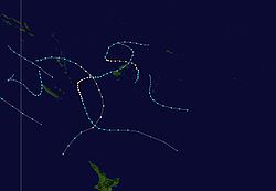
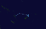
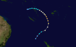
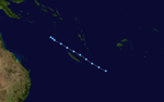
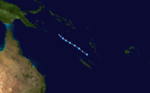
The 2007–08 South Pacific cyclone season was one of the least active tropical cyclone seasons on record, with only four tropical cyclones occurring within the South Pacific Ocean to the east of 160°E. The season officially ran from November 1, 2007 until April 30, 2008, although the first cyclone,...
was a below-average season with only four tropical cyclones, forming within the South Pacific to the east of 160°E
160th meridian east
The meridian 160° east of Greenwich is a line of longitude that extends from the North Pole across the Arctic Ocean, Asia, the Pacific Ocean, the Southern Ocean, and Antarctica to the South Pole....
.An average season has nine tropical cyclones, about half of which become severe tropical cyclones. The season officially ran from November 1, 2007 to April 30, 2008, although the first cyclone, Tropical Depression 01F, formed on October 17.
Within the South Pacific, tropical cyclones are monitored by the Regional Specialized Meteorological Center (RSMC)
Fiji Meteorological Service
The Fiji Meteorological Service is a Department of the government of Fiji responsible for providing weather forecasts and is based in Nadi. Since 1995, FMS has been responsible for naming and tracking tropical cyclones in the Southwest Pacific region...
in Nadi, Fiji, and the Tropical Cyclone Warning Center (TCWC)
Meteorological Service of New Zealand Limited
Meteorological Service of New Zealand Limited was established as a State-Owned Enterprise in 1992. It employs about 215 staff and its headquarters are in Wellington, New Zealand...
in Wellington, New Zealand. RSMC Nadi attaches an F suffix to tropical disturbances that form in or move into the South Pacific. The United States' Joint Typhoon Warning Center
Joint Typhoon Warning Center
The Joint Typhoon Warning Center is a joint United States Navy – United States Air Force task force located at the Naval Maritime Forecast Center in Pearl Harbor, Hawaii...
(JTWC) issues unofficial warnings within the South Pacific, designating tropical cyclones with a number and a P suffix. RSMC Nadi and TCWC Wellington both use the Australian Tropical Cyclone Intensity Scale, and measure wind speeds over a period of ten minutes, while the JTWC measures sustained winds over a period of one minute and uses the Saffir–Simpson Hurricane Scale.
This timeline includes information from post-storm reviews by RSMC Nadi, TCWC Wellington and the JTWC. It documents tropical cyclone formations, strengthening, weakening, landfalls, extratropical transitions, and dissipations during the season. Reports among warning centers often differ; as such, information from all three agencies has been included.
October
October 17- 1800 UTCCoordinated Universal TimeCoordinated Universal Time is the primary time standard by which the world regulates clocks and time. It is one of several closely related successors to Greenwich Mean Time. Computer servers, online services and other entities that rely on having a universally accepted time use UTC for that purpose...
, (0600 FSTUTC+12UTC+12:00 is an identifier for a +12 hour time offset from UTC. This time is used in:-As standard time :*Kiribati**Gilbert Islands and Banaba*Marshall Islands*Nauru*Russia**Chukotka Autonomous Okrug**Kamchatka Krai**Kuril Islands...
, October 17) – RSMC Nadi reports that Tropical Disturbance 01F has formed about 880 km (545 mi) to the northwest of Port VilaPort VilaPort Vila is the capital and largest city of Vanuatu. Situated on the south coast of the island of Efate, in Shefa Province, the city population at last was 29,356, an increase of 55% on the previous census result . This suggests a 2007 population of about 40,000 or around 65% of the province's...
, VanuatuVanuatuVanuatu , officially the Republic of Vanuatu , is an island nation located in the South Pacific Ocean. The archipelago, which is of volcanic origin, is some east of northern Australia, northeast of New Caledonia, west of Fiji, and southeast of the Solomon Islands, near New Guinea.Vanuatu was...
.UTC stands for Coordinated Universal TimeCoordinated Universal TimeCoordinated Universal Time is the primary time standard by which the world regulates clocks and time. It is one of several closely related successors to Greenwich Mean Time. Computer servers, online services and other entities that rely on having a universally accepted time use UTC for that purpose...
.FST stands for Fiji Standard Time, which is equivalent to UTC+12.The figures for maximum sustained windMaximum sustained windThe maximum sustained winds associated with a tropical cyclone are a common indicator of the intensity of the storm. Within a mature tropical cyclone, they are found within the eyewall at a distance defined as the radius of maximum wind, or RMW. Unlike gusts, the value of these winds are...
s and position estimates are rounded to the nearest 5 units (knots, miles, or kilometers), following the convention used in the Fiji Meteorological ServiceFiji Meteorological ServiceThe Fiji Meteorological Service is a Department of the government of Fiji responsible for providing weather forecasts and is based in Nadi. Since 1995, FMS has been responsible for naming and tracking tropical cyclones in the Southwest Pacific region...
's operational products for each storm. All other units are rounded to the nearest digit. - 2100 UTC, (0900 FST, October 17) – RSMC Nadi reports that Tropical Disturbance 01F has intensified into a tropical depression.
October 19
- 0900 UTC, (2100 FST) – RSMC Nadi issues the final advisory on Tropical Depression 01F.
November

- 0000 UTC, (1200 FST) – The 2007–08 South Pacific cyclone season2007–08 South Pacific cyclone seasonThe 2007–08 South Pacific cyclone season was one of the least active tropical cyclone seasons on record, with only four tropical cyclones occurring within the South Pacific Ocean to the east of 160°E. The season officially ran from November 1, 2007 until April 30, 2008, although the first cyclone,...
officially begins.
November 20
- 1800 UTC, (0600 FST, November 21) – RSMC Nadi reports that Tropical Depression 02F has formed about 310 km (190 mi) to the northeast of Nadi, Fiji.
November 22
- 2100 UTC, (0900 FST, November 23) – RSMC Nadi issues the final advisory on Tropical Depression 02F, as it rapidly dissipates to the southeast of Fiji.
November 24
- 2100 UTC, (0900 FST, November 25) – RSMC Nadi reports that Tropical Disturbance 03F has formed about 390 km (240 mi) to the west of Port Vila, Vanuatu.
November 25
- 0600 UTC, (1800 FST) – RSMC Nadi reports that Tropical Disturbance 03F has intensified into a tropical depression.
November 27
- 2100 UTC, (0900 FST, November 28) – RSMC Nadi reports that Tropical Depression 03F has weakened into a tropical disturbance.
November 28
- 0000 UTC, (1200 FST) – RSMC Nadi reports that Tropical Disturbance 03F has re-intensified into a tropical depression.
- 2100 UTC, (0900 FST, November 29) – RSMC Nadi reports that Tropical Depression 03F has weakened into a tropical disturbance.
November 30
- 0900 UTC, (2100 FST) – RSMC Nadi reports that Tropical Disturbance 03F has re-intensified into a tropical depression.
December

- 2100 UTC, (0900 FST, December 3) – RSMC Nadi releases the final advisory on Tropical Depression 03F.
December 3
- 0000 UTC, (1200 FST) – RSMC Nadi reports that Tropical Depression 04F has formed about 360 km (220 mi) to the northwest of Apia, SamoaSamoaSamoa , officially the Independent State of Samoa, formerly known as Western Samoa is a country encompassing the western part of the Samoan Islands in the South Pacific Ocean. It became independent from New Zealand in 1962. The two main islands of Samoa are Upolu and one of the biggest islands in...
.
December 4
- 0000 UTC, (1200 FST) – The JTWC designates Tropical Depression 04F as Tropical Cyclone 05P.
December 5
- 0000 UTC, (1200 FST) – The JTWC reports that Tropical Depression 04F (05P) has intensified into a tropical storm.
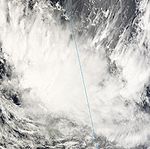
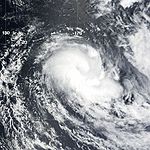
- 0200 UTC, (1400 FST) – RSMC Nadi reports that Tropical Depression 04F (05P) has intensified into a Category 1 tropical cyclone, and names it DamanCyclone DamanSevere Tropical Cyclone Daman was the strongest cyclone of the 2007–08 South Pacific cyclone season. Cyclone Daman was the fourth tropical depression and the first severe tropical cyclone to form west of longitude 160°E during the 2007–08 South Pacific cyclone season...
. - 1800 UTC, (0600 FST, December 6) – RSMC Nadi reports that Tropical Cyclone Daman (05P) has intensified into a Category 2 tropical cyclone.
December 6
- 0600 UTC, (1800 FST) – The JTWC reports that Tropical Cyclone Daman has intensified into a Category 1 tropical cyclone.
- 1200 UTC, (0000 FST, December 7) – RSMC Nadi reports that Tropical Cyclone Daman (05P) has intensified into a Category 3 severe tropical cyclone.
- 1800 UTC, (0600 FST, December 7) – The JTWC reports that Tropical Cyclone Daman (05P) has intensified into a Category 3 tropical cyclone.
December 7
- 0000 UTC, (1200 FST) – RSMC Nadi reports that Severe Tropical Cyclone Daman (05P) has intensified into a Category 4 severe tropical cyclone.
- 0600 UTC, (1800 FST) – RSMC Nadi reports that Severe Tropical Cyclone Daman (05P) has reached its peak 10-minute sustained wind speeds of 195 km/h, (120 mph).
- 1500 UTC, (0300 FST, December 8) – Severe Tropical Cyclone Daman (05P) makes landfall on Thikombia island.
December 8
- 0000 UTC, (1200 FST) – RSMC Nadi reports that Severe Tropical Cyclone Daman (05P) has weakened into a Category 3 severe tropical cyclone.
- 0000 UTC, (1200 FST) – The JTWC reports that Tropical Cyclone Daman (05P) has weakened into a Category 2 tropical cyclone.
- 0600 UTC, (1800 FST) – The JTWC reports that Tropical Cyclone Daman (05P) has weakened into a Category 1 tropical cyclone.
- 1200 UTC, (0000 FST, December 9) – RSMC Nadi reports that Severe Tropical Cyclone Daman (05P) has weakened into a Category 2 tropical cyclone.
- 1800 UTC, (0600 FST, December 9) – The JTWC reports that Tropical Cyclone Daman (05P) has weakened into a tropical storm.
December 9
- 0000 UTC, (1200 FST) – RSMC Nadi reports that Tropical Cyclone Daman (05P) has weakened into a Category 1 tropical cyclone.
- 0600 UTC, (1800 FST) – RSMC Nadi reports that Tropical Cyclone Daman (05P) has weakened into a tropical depression.
- 1200 UTC, (0000 FST, December 10) – The JTWC reports that Tropical Storm Daman (05P) has weakened into a tropical depression.
- 1800 UTC, (0600 FST, December 10) – The JTWC reports that Tropical Depression Daman (05P) has weakened into a tropical disturbance.
December 10
- 0000 UTC, (1200 FST) – RSMC Nadi issues the final advisory on Tropical Depression Daman (05P).
December 11
- 0600 UTC, (1800 FST) – RSMC Nadi reports that Tropical Depression 05F has formed about 570 km (355 mi) to the northeast of Pago Pago, in American SamoaAmerican SamoaAmerican Samoa is an unincorporated territory of the United States located in the South Pacific Ocean, southeast of the sovereign state of Samoa...
.
December 14
- 2100 UTC, (0900 FST, December 15) – RSMC Nadi issues the final advisory on Tropical Depression 05F.
December 26
- 0900 UTC, (2100 FST) – RSMC Nadi reports that Tropical Disturbance 06F has formed about 800 km (500 mi) to the northeast of AlofiAlofiAlofi is the capital city of the Pacific Ocean nation of Niue. With a population of 581 , Alofi has the distinction of being the smallest national capital city in terms of population. It consists of the two villages Alofi North and Alofi South, where the government headquarters are located. Alofi...
in NiueNiueNiue , is an island country in the South Pacific Ocean. It is commonly known as the "Rock of Polynesia", and inhabitants of the island call it "the Rock" for short. Niue is northeast of New Zealand in a triangle between Tonga to the southwest, the Samoas to the northwest, and the Cook Islands to...
.
December 28
- 0900 UTC, (2100 FST) – RSMC Nadi issues the final advisory on Tropical Disturbance 06F.
January


- 1800 UTC, (0600 FST, January 8) – RSMC Nadi reports that Tropical Depression 07F has formed about 215 km, (130 mi) to the northwest of Vavua IslandVava'uVavau is an island chain of one large island and 40 smaller ones in Tonga. According to tradition Maui fished both Tongatapu and Vavau but put a little more effort into the former. Vavau rises 204 meters above sea level...
.
January 9
- 2100 UTC, (0900 FST, January 10) – RSMC Nadi reports that Tropical Depression 08F has formed about 300 km (185 mi) to the northeast of Port VilaPort VilaPort Vila is the capital and largest city of Vanuatu. Situated on the south coast of the island of Efate, in Shefa Province, the city population at last was 29,356, an increase of 55% on the previous census result . This suggests a 2007 population of about 40,000 or around 65% of the province's...
, VanuatuVanuatuVanuatu , officially the Republic of Vanuatu , is an island nation located in the South Pacific Ocean. The archipelago, which is of volcanic origin, is some east of northern Australia, northeast of New Caledonia, west of Fiji, and southeast of the Solomon Islands, near New Guinea.Vanuatu was...
.
January 10
- 0000 UTC, (1200 FST) – RSMC Nadi reports that Tropical Depression 07F has intensified into a Category 1 tropical cyclone and names it Elisa.
- 0000 UTC, (1200 FST) – The JTWC designates Tropical Cyclone Elisa as Tropical Storm 11P.
- 1200 UTC, (0000 FST, January 11) – The JTWC reports that Tropical Cyclone Elisa (11P) has reached its 1-minute peak sustained wind speeds, of 95 km/h, (60 mph).
- 1800 UTC, (0600 FST, January 11) – RSMC Nadi reports that Tropical Cyclone Elisa (11P) has intensified into a Category 2 tropical cyclone.
- 1800 UTC, (0600 FST, January 11) – RSMC Nadi reports that Tropical Cyclone Elisa (11P) has reached its 10-minute peak sustained wind speeds, of 95 km/h, (60 mph).
January 11
- 0600 UTC, (1800 FST) – RSMC Nadi reports that Tropical Cyclone Elisa (11P) has weakened into a Category 1 tropical cyclone.
- 1200 UTC, (0000 FST, January 12) – The JTWC reports that Tropical Cyclone Elisa (11P) has weakened into a tropical depression.
- 1800 UTC, (0600 FST, January 12) – RSMC Nadi reports that Tropical Cyclone Elisa (11P) has weakened into a tropical depression.
- 1800 UTC, (0600 FST, January 12) – RSMC Nadi issues the final advisory on Tropical Cyclone Elisa (11P).
January 12
- 1800 UTC, (0600 FST, January 13) – RSMC Nadi reports that Tropical Depression 08F has weakened into a tropical disturbance.
- 2100 UTC, (0900 FST, January 13) – RSMC Nadi reports that Tropical Disturbance 08F has re-intensified into a tropical depression.
- 2100 UTC, (0900 FST, January 13) – RSMC Nadi reports that Tropical Depression 09F has formed about 160 km (100 mi) to the northeast of Nukuʻalofa.
January 13
- 2100 UTC, (0900 FST, January 14) – RSMC Nadi issues its final advisory on Tropical Depression 09F.
January 14
- 0900 UTC, (2100 FST) – RSMC Nadi reports that Tropical Depression 08F has weakened into a tropical disturbance.
- 0900 UTC, (2100 FST) – RSMC Nadi issues the final advisory on Tropical Disturbance 08F.
January 15
- 0600 UTC, (1800 FST) – RSMC Nadi reports that Tropical Depression 10F has formed about 485 km (300 mi) to the west of Espiritu SantoEspiritu SantoEspiritu Santo is the largest island in the nation of Vanuatu, with an area of . It belongs to the archipelago of the New Hebrides in the Pacific region of Melanesia. It is in the Sanma Province of Vanuatu....
island, in VanuatuVanuatuVanuatu , officially the Republic of Vanuatu , is an island nation located in the South Pacific Ocean. The archipelago, which is of volcanic origin, is some east of northern Australia, northeast of New Caledonia, west of Fiji, and southeast of the Solomon Islands, near New Guinea.Vanuatu was...
. - 1800 UTC, (1800 FST) – The JTWC designates Tropical Depression 10F as Tropical Depression 12P.
January 16
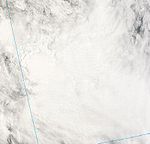
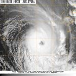
- 0600 UTC, (1800 FST) – RSMC Nadi reports that Tropical Depression 10F (12P) has intensified into a Category 1 tropical cyclone, and names it as Funa.
- 0600 UTC, (1800 FST) – The JTWC reports that Tropical Depression Funa (12P) has intensified into a tropical storm.
- 1800 UTC, (0600 FST, January 17) – RSMC Nadi reports that Tropical Cyclone Funa (12P) has intensified into a Category 2 tropical cyclone.
January 17
- 1200 UTC, (0000 FST, January 18) – The JTWC reports that Tropical Storm Funa (12P) has intensified into a Category 1 tropical cyclone.
- 1500 UTC, (0300 FST, January 18) – Tropical Cyclone Funa (12P) makes landfall near Nokuku, on Espiritu Santo island.
January 18
- 0000 UTC, (1200 FST) – RSMC Nadi reports that Tropical Cyclone Funa (12P) has intensified into a Category 3 severe tropical cyclone.
- 1200 UTC, (0000 FST, January 19) – The JTWC reports that Tropical Cyclone Funa (12P) has intensified into a Category 2 tropical cyclone.
- 1800 UTC, (0600 FST, January 19) – The JTWC reports that Tropical Cyclone Funa (12P) has intensified into a Category 3 tropical cyclone.
- 1800 UTC, (0600 FST, January 19) – The JTWC reports that Tropical Cyclone Funa (12P) has reached its peak 1-minute sustained wind speeds of 195 km/h, (120 mph).
January 19
- 0000 UTC, (1200 FST) – RSMC Nadi reports that Severe Tropical Cyclone Funa (12P) has intensified into a Category 4 severe tropical cyclone.
- 0600 UTC, (1800 FST) – RSMC Nadi reports that Severe Tropical Cyclone Funa has reached its peak 10-minute sustained wind speeds of 175 km/h (110 mph).
- 1200 UTC, (0000 FST, January 20) – The JTWC reports that Tropical Cyclone Funa (12P) has intensified into a Category 2 tropical cyclone.
- 1800 UTC, (0600 FST, January 20) – RSMC Nadi transfers primary warning responsibility of Severe Tropical Cyclone Funa to TCWC Wellington.
- 1800 UTC, (0600 FST, January 20) – TCWC Wellington reports that Severe Tropical Cyclone Funa has weakened into a Category 3 severe tropical cyclone.
- 1800 UTC, (0600 FST, January 20) – The JTWC reports that Tropical Cyclone Funa (12P) has weakened into a Category 1 tropical cyclone.
January 20
- 0600 UTC, (1800 FST) – The JTWC reports that Tropical Cyclone Funa (12P) has weakened into a tropical storm.
- 1800 UTC, (0600 FST, January 21) – TCWC Wellington reports that Tropical Cyclone Funa has transitioned into an extratropical cycloneExtratropical cycloneExtratropical cyclones, sometimes called mid-latitude cyclones or wave cyclones, are a group of cyclones defined as synoptic scale low pressure weather systems that occur in the middle latitudes of the Earth having neither tropical nor polar characteristics, and are connected with fronts and...
. - 1800 UTC, (0600 FST, January 21) – The JTWC reports that Tropical Storm Funa (12P) has weakened into a tropical depression.
- 2100 UTC, (0900 FST, January 21) – RSMC Nadi reports that Tropical Depression 11F has formed about 330 km (200 mi) to the southeast of Pago Pago, American Samoa.
January 21
- 1800 UTC, (0600 FST, January 21) – TCWC Wellington issues the final advisory on Extratropical Cyclone Funa, as it dissipates over New Zealand.
January 22
- 2100 UTC, (0900 FST, January 23) – RSMC Nadi reports that Tropical Depression 11F has weakened into a tropical depression.
January 24
- 0000 UTC, (1200 FST) – RSMC Nadi transfers primary warning responsibility of Tropical Depression 11F to TCWC Wellington.
- 1800 UTC, (0600 UTC, January 25) – TCWC Wellington issues their final advisory on Tropical Depression 11F.
January 26
- 0000 UTC, (1200 FST) – RSMC Nadi reports that Tropical Depression 12F has formed about 720 km (445 mi) to the northeast of Nadi, Fiji.
- 1800 UTC, (0600 FST, January 27) – The JTWC designates Tropical Depression 12F as Tropical Depression 15P.
January 27
- 1800 UTC, (0600 FST, January 28) – The JTWC reports that Tropical Depression 12F (15P) has intensified into a tropical storm.
January 28
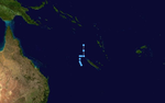
- 0000 UTC, (1200 FST, January 28) – For humanitarian reasons, RSMC Nadi names Tropical Depression 12F (15P) as Gene.
- 0600 UTC, (1800 FST. January 28) – Tropical Cyclone Gene (15P) makes landfall near Nanukuloa, on Viti LevuViti LevuViti Levu is the largest island in the Republic of Fiji, the site of the nation's capital, Suva, and home to a large majority of Fiji's population.- Geography and economy :...
island, FijiFijiFiji , officially the Republic of Fiji , is an island nation in Melanesia in the South Pacific Ocean about northeast of New Zealand's North Island...
. - 0600 UTC, (1800 FST, January 28) – RSMC Nadi reports that Tropical Depression Gene (15P) has intensified into a Category 1 tropical cyclone.
January 29
- 0000 UTC, (1200 FST, January 29) – RSMC Nadi reports that Tropical Cyclone Gene (15P) has intensified into a Category 2 tropical cyclone.
- 1200 UTC, (0000 FST, January 30) – RSMC Nadi reports that Tropical Cyclone Gene (15P) has weakened into a Category 1 tropical cyclone.
- 1800 UTC, (0600 FST, January 30) – RSMC Nadi reports that Tropical Cyclone Gene (15P) has re-intensified into a Category 1 tropical Cyclone.
January 30
- 0600 UTC, (1800 FST) – The JTWC reports that Tropical Storm Gene (15P) has intensified into a Category 1 tropical cyclone.
- 1200 UTC, (0000 FST, January 31) – RSMC Nadi reports that Tropical Cyclone Gene (15P) has intensified into a Category 3 severe tropical cyclone.
- 1800 UTC, (0600 FST, January 31) – The JTWC reports that Tropical Cyclone Gene (15P) has intensified into a Category 3 tropical cyclone.
January 31
- 1200 UTC, (0000 FST, January 31) – The JTWC reports that Tropical Cyclone Gene (15P) has intensified into a Category 3 tropical cyclone.
- 1800 UTC, (0600 FST, January 31) – RSMC Nadi reports that Severe Tropical Cyclone Gene (15P) has reached its peak 10-minute sustained wind speeds of 160 km/h, (100 mph).
- 1800 UTC, (0600 FST, January 31) – The JTWC reports that Tropical Cyclone Gene (15P) has reached its peak 1-minute sustained wind speeds of 185 km/h (115 mph).
February


- 0600 UTC, (1800 FST) – The JTWC reports that Tropical Cyclone Gene (15P) has weakened into a Category 2 tropical cyclone.
- 1800 UTC, (0600 FST, February 2) – The JTWC reports that Tropical Cyclone Gene (15P) has weakened into a Category 1 tropical cyclone.
February 2
- 1200 UTC, (0000 FST, February 3) – RSMC Nadi reports that Severe Tropical Cyclone Gene (15P) has weakened into a Category 2 tropical cyclone.
February 3
- 0000 UTC, (1200 FST) – The JTWC reports that Tropical Cyclone Gene (15P) has weakened into a tropical storm.
- 1800 UTC, (0600 FST, February 4) – RSMC Nadi transfers primary warning responsibility of Tropical Cyclone Gene to TCWC Wellington.
- 1800 UTC, (0600 FST, February 4) – TCWC Wellington reports that Tropical Cyclone Gene (15P) has re–intensified into a Category 3 severe tropical cyclone.
February 4
- 0600 UTC (1800 FST, February 5) – TCWC Wellington reports that Tropical Cyclone Gene (15P) has weakened into a Category 2 tropical cyclone.
February 6
- 0000 UTC, (1200 FST) – TCWC Wellington reports that Tropical Cyclone Gene (15P) has re–intensified into a Category 3 severe tropical cyclone.
- 0000 UTC, (1200 FST) – The JTWC reports that Tropical Storm Gene (15P) has transitioned into an extratropical cyclone.
- 0600 UTC, (1800 FST) – TCWC Wellington reports that Tropical Cyclone Gene (15P) has transitioned into an extratropical cyclone.
February 9
- 0000 UTC, (1200 FST) – TCWC Wellington release the final advisory on Extratropical Cyclone Gene.
February 17
- 1800 UTC, (0600 FST, February 18) – RSMC Nadi reports that Tropical Depression 13F has formed about 1250 km (775 mi) to the southeast of Pago Pago in American SamoaAmerican SamoaAmerican Samoa is an unincorporated territory of the United States located in the South Pacific Ocean, southeast of the sovereign state of Samoa...
.
February 18
- 2100 UTC, (0900 FST, February 19) – RSMC Nadi issues the final advisory on Tropical Depression 13F.
March
- 1800 UTC (0600 FST, March 20) – RSMC Nadi reports that Tropical Disturbance 14F has formed about 500 km (310 mi) to the west of Port Vila, Vanuatu.
- 2100 UTC (0900 FST, March 20) – RSMC Nadi reports that Tropical Disturbance 14F has intensified into a tropical depression.
March 20
- 0000 UTC, (1200 FST) – The JTWC designates Tropical Depression 14F as Tropical Depression 24P.
- 1800 UTC, (0600 FST, March 21) – The JTWC reports that Tropical Depression 14F (24P) has intensified into a tropical storm.
- 1800 UTC, (0600 FST, March 21) – The JTWC reports that Tropical Storm 14F (24P) has reached its peak 1-minute sustained wind speeds of 65 km/h (40 mph).
March 21
- 0000 UTC, (1200 FST) – Tropical Depression 14F (24P) makes landfall on the main island of New CaledoniaNew CaledoniaNew Caledonia is a special collectivity of France located in the southwest Pacific Ocean, east of Australia and about from Metropolitan France. The archipelago, part of the Melanesia subregion, includes the main island of Grande Terre, the Loyalty Islands, the Belep archipelago, the Isle of...
. - 1800 UTC, (0600 FST, March 22) – The JTWC reports that Tropical Storm 14F (24P) has weakened into a tropical depression.
March 22
- 1800 UTC, (0600 FST, March 23) – RSMC Nadi reports that Tropical Depression 14F (24P) has weakened into a tropical disturbance.
- 1800 UTC, (0600 FST, March 23) – The JTWC reports that Tropical Depression 14F (24P) has weakened into a tropical disturbance.
March 23
- 2100 UTC, (0900 FST, March 24) – RSMC Nadi issues the final advisory on Tropical Disturbance 14F.
April
- 1800 UTC, (0600 FST, April 5) – RSMC Nadi reports that Tropical Disturbance 15F has formed about 1000 km, (620 mi) to the west of Vanuatu.
- 2300 UTC, (1100 FST, April 5) – RSMC Nadi reports that Tropical Disturbance 15F has intensified into a tropical depression.
April 7
- 0900 UTC, (2100 FST) – RSMC Nadi issues the final advisory on Tropical Depression 15F.
April 17
- 1200 UTC, (0000 FST, April 18) – The JTWC reports that Tropical Depression 27P has formed about 1115 km (695 mi) to the west of Port Vila, Vanuatu.
- 1800 UTC, (0600 FST, April 18) – RSMC Nadi designates Tropical Depression 27P as Tropical Depression 16F.
- 1800 UTC, (0600 FST, April 18) – The JTWC reports that Tropical Depression 16F (27P) has reached its peak 1-minute sustained wind speeds of 55 km/h, (35 mph).
April 18
- 1800 UTC, (0600 FST, April 18) – The JTWC reports that Tropical Depression 16F (27P) has weakened into a tropical disturbance.
April 19
- 2100 UTC, (0900 FST, April 20) – RSMC Nadi issues the final advisory on Tropical Depression 16F.
April 30
- 1200 UTC, (0000 FST, May 1) – The 2007–08 South Pacific tropical cyclone season officially ends.
See also
- 2007–08 South Pacific cyclone season2007–08 South Pacific cyclone seasonThe 2007–08 South Pacific cyclone season was one of the least active tropical cyclone seasons on record, with only four tropical cyclones occurring within the South Pacific Ocean to the east of 160°E. The season officially ran from November 1, 2007 until April 30, 2008, although the first cyclone,...
- List of Southern Hemisphere tropical cyclone seasons
- Atlantic hurricane season timelines: 2007Timeline of the 2007 Atlantic hurricane seasonThis timeline documents all the storm formations, strengthening, weakening, landfalls, extratropical transitions, as well as dissipation during the 2007 Atlantic hurricane season. The season officially began on June 1, 2007, and ended on November 30, although Subtropical Storm Andrea and Tropical...
, 2008Timeline of the 2008 Atlantic hurricane seasonThe 2008 Atlantic hurricane season was a well above-average year in which sixteen named storms formed, making it the fourth most active season ever recorded. An average season has eleven tropical storms, six hurricanes and two major hurricanes... - Pacific hurricane season timelines: 2007Timeline of the 2007 Pacific hurricane seasonThe 2007 Pacific hurricane season was an event in the annual cycle of tropical cyclone formation. This timeline documents all the storm formations, strengthening, weakening, landfalls, extratropical transitions, and dissipation...
, 2008Timeline of the 2008 Pacific hurricane seasonBelow is the Timeline of the 2008 Pacific hurricane season, documenting all the storm formations, strengthening, weakening, landfalls, extratropical transitions, as well as dissipation. The 2008 Pacific hurricane season officially began on May 15, 2008, and will last until November 30. For... - Pacific typhoon season timelines: 2007Timeline of the 2007 Pacific typhoon seasonThe 2007 Pacific typhoon season had no official bounds; it ran year-round in 2007, but most tropical cyclones tend to form in the northwestern Pacific Ocean between May and November...
, 2008Timeline of the 2008 Pacific typhoon seasonThis timeline documents all the storm formations, strengthening, weakening, landfalls, extratropical transitions, as well as dissipation during the 2008 Pacific typhoon season. The 2008 Pacific typhoon season officially started on January 1, 2008 and ended on January 1, 2009. The first tropical... - North Indian Ocean cyclone season timelines: 2007Timeline of the 2007 North Indian Ocean cyclone seasonBelow is a timeline of the 2007 North Indian Ocean cyclone season, documenting major events with regards to tropical cyclone formation, strengthening, weakening, landfall, extratropical transition, as well as dissipation...
, 2008Timeline of the 2008 North Indian Ocean cyclone seasonThe 2008 North Indian Ocean cyclone season officially ran throughout the year during 2008, with the first depression forming on April 27. The timeline includes information that was not operationally released, meaning that information from post-storm reviews by the Joint Typhoon Warning Center , and... - Timeline of the 2007–08 South-West Indian Ocean cyclone season
- Timeline of the 2007–08 Australian region cyclone season