

Timeline of the 2007 Pacific hurricane season
Encyclopedia
2007 Pacific hurricane season
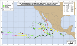
The 2007 Pacific hurricane season was an event in the annual cycle of tropical cyclone formation. It officially started on May 15, 2007 in the eastern Pacific, designated as the area east of 140°W, and on June 1, 2007 in the central Pacific, which is between the International Date Line and 140°W,...
was an event in the annual cycle of tropical cyclone
Tropical cyclone
A tropical cyclone is a storm system characterized by a large low-pressure center and numerous thunderstorms that produce strong winds and heavy rain. Tropical cyclones strengthen when water evaporated from the ocean is released as the saturated air rises, resulting in condensation of water vapor...
formation. This timeline documents all the storm formations, strengthening, weakening, landfalls
Landfall (meteorology)
Landfall is the event of a tropical cyclone or a waterspout coming onto land after being over water. When a waterspout makes landfall it is reclassified as a tornado, which can then cause damage inland...
, extratropical transitions, and dissipation. The timeline also includes information which was not operationally released, which is information from post-storm analysis by the National Hurricane Center
National Hurricane Center
The National Hurricane Center , located at Florida International University in Miami, Florida, is the division of the National Weather Service responsible for tracking and predicting weather systems within the tropics between the Prime Meridian and the 140th meridian west poleward to the 30th...
.
The season officially started on May 15, 2007 in the eastern Pacific, designated as the area east of 140°W, and on June 1, 2007 in the central Pacific, which is between the International Date Line
International Date Line
The International Date Line is a generally north-south imaginary line on the surface of the Earth, passing through the middle of the Pacific Ocean, that designates the place where each calendar day begins...
and 140°W, and lasted until November 30, 2007. These dates conventionally delimit the period of each year when most tropical cyclones form in the Pacific basin. The season began slowly; through the end of July, the seasonal Accumulated Cyclone Energy
Accumulated cyclone energy
Accumulated cyclone energy is a measure used by the National Oceanic and Atmospheric Administration to express the activity of individual tropical cyclones and entire tropical cyclone seasons, particularly the North Atlantic hurricane season. It uses an approximation of the energy used by a...
(ACE) was the third lowest since the geostationary satellite era began in the 1966 Pacific hurricane season
1966 Pacific hurricane season
The 1966 Pacific hurricane season started on May 15, 1966 and ended November 30, 1966. The season was of little note. Hurricane Blanca traveled 4,300 miles, setting a new record. During September and October of the year, Hurricane Helga and Tropical Storms Kirsten, Lorraine, and Maggie hitting Mexico...
. The inactivity continued through the next month, which was the third quietest August in terms of ACE since reliable records began in the basin during the 1971 Pacific hurricane season
1971 Pacific hurricane season
The 1971 Pacific hurricane season began on May 15, 1971 in the east Pacific, and on June 1, 1971 in the central Pacific. It ended on November 30, 1971. These dates conventionally delimit the period of time when tropical cyclones form in the east Pacific Ocean....
. In June, Tropical Storm Barbara
Tropical Storm Barbara (2007)
Tropical Storm Barbara was the first tropical cyclone to make landfall during the 2007 Pacific hurricane season. The second storm of the season, Barbara developed from a small low pressure area on May 29 about 235 miles southeast of Acapulco, Mexico. The system drifted southward before...
caused $55 million (2007 USD) in crop damage to southeastern Mexico from heavy precipitation. In August, Hurricane Flossie
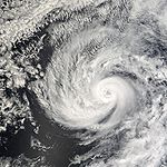
Hurricane Flossie (2007)
Hurricane Flossie was a strong Category Four Hurricane which brushed the island of Hawaiʻi as it rapidly weakened to a tropical storm. Flossie was the ninth tropical cyclone and sixth named storm of the 2007 Pacific hurricane season. Flossie developed from an ill defined wave which formed off the...
formed in the eastern Pacific and crossed into the central Pacific; the hurricane threatened Hawaii
Hawaii
Hawaii is the newest of the 50 U.S. states , and is the only U.S. state made up entirely of islands. It is the northernmost island group in Polynesia, occupying most of an archipelago in the central Pacific Ocean, southwest of the continental United States, southeast of Japan, and northeast of...
but caused little damage. In early September, Hurricane Henriette
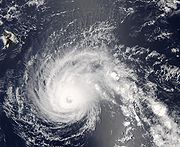
Hurricane Henriette (2007)
Hurricane Henriette was the deadliest tropical cyclone of the 2007 Pacific hurricane season. The storm, which caused nine fatalities, formed from an area of disturbed weather on August 30, 2007, and became a tropical storm the next day. The cyclone moved parallel to the Mexican Pacific coast, but...
dropped heavy rainfall in southwest Mexico, which caused nine fatalities and $25 million (2007 USD) in damage.
May
May 15- The Eastern Pacific hurricane season officially begins.
May 26
- 5:00 p.m. PDT (00:00 UTC May 27) – Tropical Depression One-E forms 345 mi (555 km) south of the tip of Baja CaliforniaBaja CaliforniaBaja California officially Estado Libre y Soberano de Baja California is one of the 31 states which, with the Federal District, comprise the 32 Federal Entities of Mexico. It is both the northernmost and westernmost state of Mexico. Before becoming a state in 1953, the area was known as the North...
.
May 28
- 5:00 p.m. PDT (00:00 UTC May 29) – Tropical Depression One-E strengthens into Tropical Storm Alvin.
May 29
- 11:00 a.m. PDT (18:00 UTC) – Tropical Depression Two-E forms 115 mi (185 km) south-southeast of Puerto Escondido, Oaxaca, Mexico.
- 11:00 p.m. PDT (06:00 UTC May 30) – Tropical Storm Alvin weakens to a tropical depression.
.jpg)
- 5:00 a.m. PDT (12:00 UTC) – Tropical Depression Two-E strengthens into Tropical Storm BarbaraTropical Storm Barbara (2007)Tropical Storm Barbara was the first tropical cyclone to make landfall during the 2007 Pacific hurricane season. The second storm of the season, Barbara developed from a small low pressure area on May 29 about 235 miles southeast of Acapulco, Mexico. The system drifted southward before...
.
May 31
- 5:00 p.m. PDT (00:00 UTC June 1) – Tropical Depression Alvin degenerates into a remnant low.
- 5:00 p.m. PDT (00:00 UTC June 1) – Tropical Storm Barbara weakens to a tropical depression.
- 11:00 p.m. PDT (06:00 UTC June 1) – Tropical Depression Barbara restrengthens into a tropical storm.
June
June 2- 6:00 a.m. PDT (13:00 UTC) – Tropical Storm Barbara makes landfall just northwest of the Mexico–GuatemalaGuatemalaGuatemala is a country in Central America bordered by Mexico to the north and west, the Pacific Ocean to the southwest, Belize to the northeast, the Caribbean to the east, and Honduras and El Salvador to the southeast...
border with 50 mph (85 km/h) winds.The figures for maximum sustained windMaximum sustained windThe maximum sustained winds associated with a tropical cyclone are a common indicator of the intensity of the storm. Within a mature tropical cyclone, they are found within the eyewall at a distance defined as the radius of maximum wind, or RMW. Unlike gusts, the value of these winds are...
s and position estimates are rounded to the nearest 5 units (knots, miles, or kilometers), following the convention used in the National Hurricane CenterNational Hurricane CenterThe National Hurricane Center , located at Florida International University in Miami, Florida, is the division of the National Weather Service responsible for tracking and predicting weather systems within the tropics between the Prime Meridian and the 140th meridian west poleward to the 30th...
's operational products for each storm. All other units are rounded to the nearest digit. - 11:00 a.m. PDT (18:00 UTC) – Tropical Storm Barbara weakens back to a tropical depression.
- 5:00 p.m. PDT (00:00 UTC June 3) – Tropical Depression Barbara dissipates.
June 11
- 5:00 a.m. PDT (12:00 UTC) – Tropical Depression Three-E forms 520 miles (835 km) south of the southern tip of the Baja California peninsulaBaja California PeninsulaThe Baja California peninsula , is a peninsula in northwestern Mexico. Its land mass separates the Pacific Ocean from the Gulf of California. The Peninsula extends from Mexicali, Baja California in the north to Cabo San Lucas, Baja California Sur in the south.The total area of the Baja California...
.
June 12
- 5:00 p.m. PDT (00:00 UTC June 13) – Tropical Depression Three-E degenerates into a remnant low.
July
July 9- 11:00 a.m. PDT (18:00 UTC) – Tropical Depression Four-E forms several hundred miles southwest of Baja CaliforniaBaja CaliforniaBaja California officially Estado Libre y Soberano de Baja California is one of the 31 states which, with the Federal District, comprise the 32 Federal Entities of Mexico. It is both the northernmost and westernmost state of Mexico. Before becoming a state in 1953, the area was known as the North...
.
July 10
- 11:00 p.m. PDT (06:00 UTC July 11) – Tropical Depression Four-E degenerates to a remnant low.
July 14
- 5:00 a.m. PDT (12:00 UTC) – Tropical Depression Five-E forms about 690 mi (1,110 km) south-southwest of the southern tip of Baja CaliforniaBaja CaliforniaBaja California officially Estado Libre y Soberano de Baja California is one of the 31 states which, with the Federal District, comprise the 32 Federal Entities of Mexico. It is both the northernmost and westernmost state of Mexico. Before becoming a state in 1953, the area was known as the North...
. - 5:00 a.m. PDT (12:00 UTC) – Tropical Depression Six-E forms about halfway between Mexico and the Hawaiian islandsHawaiian IslandsThe Hawaiian Islands are an archipelago of eight major islands, several atolls, numerous smaller islets, and undersea seamounts in the North Pacific Ocean, extending some 1,500 miles from the island of Hawaii in the south to northernmost Kure Atoll...
.
July 15
- 11:00 a.m. PDT (18:00 UTC) – Tropical Depression Six-E strengthens into Tropical Storm Cosme.
- 5:00 p.m. PDT (00:00 UTC July 16) – Tropical Depression Five-E degenerates into a remnant low.
- 11:00 a.m. PDT (18:00 UTC) – Tropical Storm Cosme strengthens into Hurricane CosmeHurricane Cosme (2007)Hurricane Cosme was a minimal hurricane that threatened Hawaii in mid-July 2007. The sixth tropical cyclone, third named storm and first hurricane of the 2007 Pacific hurricane season, Cosme originated from a tropical wave that emerged off the coast of Africa on June 27 and tracked westward before...
. - 5:00 p.m. PDT (00:00 UTC July 17) – Hurricane Cosme is downgraded to a tropical storm.
July 18
- c. 11:00 a.m. PDT (8:00 a.m. HST, 18:00 UTC) – Tropical Storm Cosme is downgraded to a tropical depression as it crosses the 140°W boundary and moves into the Central Pacific Hurricane CenterCentral Pacific Hurricane CenterThe Central Pacific Hurricane Center of the United States National Weather Service is the official body responsible for tracking and issuing tropical cyclone warnings, watches, advisories, discussions, and statements for the Central North Pacific Basin...
's area of responsibility.
July 21
- 5:00 p.m. PDT (00:00 UTC July 22) – Tropical Depression Seven-E forms south of Manzanillo.
July 22
- 8:00 a.m. HST (18:00 UTC) – The final advisory is issued on dissipating Tropical Depression Cosme.
July 23
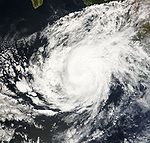
- 5:00 p.m. PDT (00:00 UTC July 24) – Tropical Depression Seven-E strengthens into Tropical Storm DalilaTropical Storm Dalila (2007)Tropical Storm Dalila was a tropical storm that was active in the 2007 Pacific hurricane season. The seventh tropical cyclone and the fourth named tropical storm of the season, Dalila came from a tropical wave that entered the Eastern Pacific Ocean on July 17, 2007. It became a tropical depression...
.
July 26
- 11:00 p.m. PDT (06:00 UTC July 27) – Tropical Storm Dalila is downgraded to a tropical depression.
July 27
- 11:00 a.m. PDT (18:00 UTC) – Tropical Depression Dalila weakens into a low.
July 31
- 5:00 a.m. PDT (12:00 UTC) – Tropical Depression Eight-E forms 1,070 mi (1,715 km) southwest of the southern tip of Baja CaliforniaBaja CaliforniaBaja California officially Estado Libre y Soberano de Baja California is one of the 31 states which, with the Federal District, comprise the 32 Federal Entities of Mexico. It is both the northernmost and westernmost state of Mexico. Before becoming a state in 1953, the area was known as the North...
. - 5:00 p.m. PDT (01:00 UTC August 1) – Tropical Depression Eight-E strengthens into Tropical Storm ErickTropical Storm Erick (2007)Tropical Storm Erick was the eighth tropical cyclone of the 2007 Pacific hurricane season, and the fifth to attain tropical storm status. Erick originated from a tropical wave that moved off the coast of Africa, traveled westward across the Atlantic, and emerged into the Eastern Pacific Ocean...
.
August
August 1- 5:00 p.m. PDT (00:00 UTC August 2) – Tropical Storm Erick weakens into a tropical depression.
- 11:00 p.m. PDT (06:00 UTC August 2) – Tropical Depression Erick degenerates into a tropical waveTropical waveTropical waves, easterly waves, or tropical easterly waves, also known as African easterly waves in the Atlantic region, are a type of atmospheric trough, an elongated area of relatively low air pressure, oriented north to south, which move from east to west across the tropics causing areas of...
.
August 8
- 11:00 a.m. PDT (18:00 UTC) – Tropical Depression Nine-E forms well to the southwest of Baja CaliforniaBaja CaliforniaBaja California officially Estado Libre y Soberano de Baja California is one of the 31 states which, with the Federal District, comprise the 32 Federal Entities of Mexico. It is both the northernmost and westernmost state of Mexico. Before becoming a state in 1953, the area was known as the North...
. - 5:00 p.m. PDT (00:00 UTC August 9) – Tropical Depression Nine-E is upgraded to Tropical Storm Flossie.
- 5:00 a.m. PDT (12:00 UTC) – Tropical Storm Flossie is upgraded to Hurricane FlossieHurricane Flossie (2007)Hurricane Flossie was a strong Category Four Hurricane which brushed the island of Hawaiʻi as it rapidly weakened to a tropical storm. Flossie was the ninth tropical cyclone and sixth named storm of the 2007 Pacific hurricane season. Flossie developed from an ill defined wave which formed off the...
. - 11:00 p.m. PDT (06:00 UTC August 11) – Hurricane Flossie is upgraded to a Category 3 major hurricane, becoming the first major hurricane of the season.
August 11
- 5:00 a.m. PDT (12:00 UTC, 2 a.m. HSTHawaii-Aleutian time zoneThe Hawaii-Aleutian Time Zone observes Hawaii-Aleutian Standard Time , by subtracting ten hours from Coordinated Universal Time . The clock time in this zone is based on the mean solar time of the 150th meridian west of the Greenwich Observatory....
) – Hurricane Flossie is upgraded to a Category 4 hurricane, and crosses 140°W into the Central Pacific Hurricane CenterCentral Pacific Hurricane CenterThe Central Pacific Hurricane Center of the United States National Weather Service is the official body responsible for tracking and issuing tropical cyclone warnings, watches, advisories, discussions, and statements for the Central North Pacific Basin...
's area of responsibility.
August 15
- 2:00 a.m. HST (12:00 UTC) – Hurricane Flossie is downgraded to a tropical storm.
- 8:00 p.m. HST (06:00 UTC August 16) – Tropical Storm Flossie is downgraded to a tropical depression.
August 16
- 8:00 a.m. HST (18:00 UTC) – Tropical Depression Flossie dissipates.
August 29
- 5:00 a.m. PDT (12:00 UTC) – Tropical Depression Ten-E forms west of Manzanillo, MexicoManzanillo, ColimaThe name Manzanillo refers to the city as well as its surrounding municipality in the Mexican state of Colima. The city, located on the Pacific Ocean, contains Mexico's busiest port. Manzanillo was the third port created by the Spanish in the Pacific during the New Spain period...
. - 11:00 a.m. PDT (18:00 UTC) – Tropical Depression Ten-E is upgraded to Tropical Storm Gil.
August 29
- 11:00 p.m. PDT (06:00 UTC August 30) – Tropical Depression Eleven-E forms southeast of AcapulcoAcapulcoAcapulco is a city, municipality and major sea port in the state of Guerrero on the Pacific coast of Mexico, southwest from Mexico City. Acapulco is located on a deep, semi-circular bay and has been a port since the early colonial period of Mexico’s history...
, Mexico.
August 31
- 5:00 a.m. PDT (12:00 UTC) – Tropical Depression Eleven-E is upgraded to Tropical Storm Henriette.
August 31
- 5:00 p.m. PDT (00:00 UTC September 1) – Tropical Storm Gil is downgraded to a tropical depression.
September
September 2- 11:00 a.m. PDT (18:00 UTC) – Tropical Depression Gil is downgraded to a remnant low.
September 3
- 11:00 p.m. PDT (06:00 UTC September 4) – Tropical Storm Henriette is upgraded to Hurricane HenrietteHurricane Henriette (2007)Hurricane Henriette was the deadliest tropical cyclone of the 2007 Pacific hurricane season. The storm, which caused nine fatalities, formed from an area of disturbed weather on August 30, 2007, and became a tropical storm the next day. The cyclone moved parallel to the Mexican Pacific coast, but...
.
September 4
- 2:00 p.m. PDT (21:00 UTC) – Hurricane Henriette makes landfall just east of San José del CaboSan José del CaboThe city of San José del Cabo is located in Baja California Sur Mexico and is the seat of the municipality of Los Cabos at the south end of the Baja California peninsula. In the 2010 census it had a population of 69,788. Together with neighboring Cabo San Lucas it forms a major tourist destination...
, Mexico with 80 mph (130 km/h) winds.
September 5
- 5:00 p.m. PDT (00:00 UTC September 6) – Hurricane Henriette is downgraded to a tropical storm.
- 5:00 p.m. PDT (00:00 UTC September 6) – Tropical Storm Henriette makes a second landfall near GuaymasGuaymasGuaymas is a city and municipality located in the southwest part of the state of Sonora in northwestern Mexico. The city is located 117 km south of the state capital of Hermosillo, and 242 miles from the U.S. border, and is the principal port for the state. The municipality is located in the...
, Mexico.
September 5
- 11:00 p.m. PDT (06:00 UTC September 6) – Tropical Storm Henriette is downgraded to a tropical depression.

- 5:00 a.m. PDT (12:00 UTC) – Tropical Depression Henriette dissipates.
September 17
- 11:00 p.m. PDT (06:00 UTC September 18) – Tropical Depression Twelve-E forms south-southeast of the southern tip of Baja CaliforniaBaja CaliforniaBaja California officially Estado Libre y Soberano de Baja California is one of the 31 states which, with the Federal District, comprise the 32 Federal Entities of Mexico. It is both the northernmost and westernmost state of Mexico. Before becoming a state in 1953, the area was known as the North...
.
September 18
- 5:00 p.m. PDT (00:00 UTC September 19) – Tropical Depression Twelve-E is upgraded to Tropical Storm Ivo.
September 18
- 11:00 p.m. PDT (06:00 UTC September 19) – Tropical Depression Thirteen-E forms west-southwest of the southern tip of Baja CaliforniaBaja CaliforniaBaja California officially Estado Libre y Soberano de Baja California is one of the 31 states which, with the Federal District, comprise the 32 Federal Entities of Mexico. It is both the northernmost and westernmost state of Mexico. Before becoming a state in 1953, the area was known as the North...
.
September 19
- 5:00 p.m. PDT (00:00 UTC September 20) – Tropical Storm Ivo is upgraded to Hurricane IvoHurricane Ivo (2007)Hurricane Ivo was a minimal hurricane that threatened the coast of Mexico during mid-September 2007. The 12th tropical cyclone, ninth named storm and fourth hurricane of the 2007 Pacific hurricane season, Ivo originated from a tropical wave that left the coast of Africa on September 1 and traversed...
.
September 20
- 5:00 p.m. PDT (00:00 UTC September 21) – Tropical Depression Thirteen-E is downgraded to a remnant low.
September 21
- 11:00 a.m. PDT (18:00 UTC) – Hurricane Ivo is downgraded to a tropical storm.
September 22
- 5:00 p.m. PDT (00:00 UTC September 23) – Tropical Storm Ivo is downgraded to a tropical depression.
September 23
- 11:00 a.m. PDT (18:00 UTC) – Tropical Depression Ivo is downgraded to a low.
September 28
- 5:00 p.m. PDT (00:00 UTC September 29) – Tropical Depression Fourteen-E forms west-southwest of ManzanilloManzanillo, ColimaThe name Manzanillo refers to the city as well as its surrounding municipality in the Mexican state of Colima. The city, located on the Pacific Ocean, contains Mexico's busiest port. Manzanillo was the third port created by the Spanish in the Pacific during the New Spain period...
.
September 29
- 5:00 a.m. PDT (12:00 UTC) – Tropical Depression Fourteen-E is upgraded to Tropical Storm Juliette.
October
October 1- 5:00 p.m. PDT (00:00 UTC October 2) – Tropical Storm Juliette is downgraded to a tropical depression.
October 2
- 5:00 a.m. PDT (12:00 UTC) – Tropical Depression Juliette is downgraded to a remnant low.
October 14
- 5:00 p.m. PDT (00:00 UTC October 15) – Tropical Depression Fifteen-E forms southwest of ManzanilloManzanillo, ColimaThe name Manzanillo refers to the city as well as its surrounding municipality in the Mexican state of Colima. The city, located on the Pacific Ocean, contains Mexico's busiest port. Manzanillo was the third port created by the Spanish in the Pacific during the New Spain period...
.
- 5:00 a.m. PDT (12:00 UTC) – Tropical Depression Fifteen-E is upgraded to Tropical Storm KikoTropical Storm Kiko (2007)Tropical Storm Kiko was a strong tropical storm that capsized a boat off the western coast of Mexico, killing at least 15 people. The 15th and final tropical cyclone of the 2007 Pacific hurricane season, Kiko developed out of a tropical wave that formed off the coast of Africa on September 26...
. - 11:00 a.m. PDT (18:00 UTC) – Tropical Storm Kiko is downgraded to a tropical depression.
October 16
- 11:00 p.m. PDT (06:00 UTC October 17) – Tropical Depression Kiko restrengthens into a tropical storm.
October 22
- 5:00 p.m. PDT (00:00 UTC October 23) – Tropical Storm Kiko is downgraded to a tropical depression.
October 23
- 5:00 p.m. PDT (00:00 UTC October 24) – Tropical Depression Kiko is downgraded to a remnant low.
See also
- 2007 Pacific hurricane season2007 Pacific hurricane seasonThe 2007 Pacific hurricane season was an event in the annual cycle of tropical cyclone formation. It officially started on May 15, 2007 in the eastern Pacific, designated as the area east of 140°W, and on June 1, 2007 in the central Pacific, which is between the International Date Line and 140°W,...
- List of Pacific hurricane seasons
- Timeline of the 2007 Atlantic hurricane seasonTimeline of the 2007 Atlantic hurricane seasonThis timeline documents all the storm formations, strengthening, weakening, landfalls, extratropical transitions, as well as dissipation during the 2007 Atlantic hurricane season. The season officially began on June 1, 2007, and ended on November 30, although Subtropical Storm Andrea and Tropical...
- Timeline of the 2007 Pacific typhoon seasonTimeline of the 2007 Pacific typhoon seasonThe 2007 Pacific typhoon season had no official bounds; it ran year-round in 2007, but most tropical cyclones tend to form in the northwestern Pacific Ocean between May and November...
- Timeline of the 2007 North Indian Ocean cyclone seasonTimeline of the 2007 North Indian Ocean cyclone seasonBelow is a timeline of the 2007 North Indian Ocean cyclone season, documenting major events with regards to tropical cyclone formation, strengthening, weakening, landfall, extratropical transition, as well as dissipation...
- Timeline of the 2007-08 South-West Indian Ocean cyclone seasonTimeline of the 2007-08 South-West Indian Ocean cyclone seasonBelow is a timeline of the 2007-08 South-West Indian Ocean cyclone season, documenting all the storm formations, strengthening, weakening, landfalls, extratropical transitions, as well as dissipation....
- Timeline of the 2007-08 South Pacific cyclone season
- Timeline of the 2007-08 Australian region cyclone seasonTimeline of the 2007-08 Australian region cyclone seasonThe 2007–08 Australian region cyclone season was only the second season to have a tropical cyclone form in July. This timeline documents all the storm formations, strengthening, weakening, landfalls, extratropical transitions, as well as dissipation. The season officially began on 1 November 2007,...
- 1966 Pacific hurricane season1950-1969 Pacific hurricane seasonsThe 1950–1963 Pacific hurricane seasons all began on May 15, 1950-65 in the northeast Pacific Ocean and on June 1, 1950-65 in the central Pacific. They ended on November 30, 1950-65...
and 1971 Pacific hurricane season1971 Pacific hurricane seasonThe 1971 Pacific hurricane season began on May 15, 1971 in the east Pacific, and on June 1, 1971 in the central Pacific. It ended on November 30, 1971. These dates conventionally delimit the period of time when tropical cyclones form in the east Pacific Ocean....
, seasons with similar bouts of inactivity