

Sunol Water Temple
Encyclopedia
Sunol, California
Sunol is an unincorporated census-designated place in Alameda County, California, United States. The population was 913 at the 2010 census....
. Designed by Willis Polk
Willis Polk
Willis Jefferson Polk was an American architect best known for his work in San Francisco, California.-Life:He was born in Jacksonville, Illinois and was related to United States President James Polk....
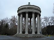
, the 59 foot high classical pavilion is made up of twelve concrete Corinthian
Corinthian order
The Corinthian order is one of the three principal classical orders of ancient Greek and Roman architecture. The other two are the Doric and Ionic. When classical architecture was revived during the Renaissance, two more orders were added to the canon, the Tuscan order and the Composite order...
column
Column
A column or pillar in architecture and structural engineering is a vertical structural element that transmits, through compression, the weight of the structure above to other structural elements below. For the purpose of wind or earthquake engineering, columns may be designed to resist lateral forces...
s and a concrete ring girder
Girder
A girder is a support beam used in construction. Girders often have an I-beam cross section for strength, but may also have a box shape, Z shape or other forms. Girder is the term used to denote the main horizontal support of a structure which supports smaller beams...
that supports the conical wood and tile roof. Inside the temple, water originally from the Pleasanton well fields and Arroyo de la Laguna flowed into a white tiled cistern
Cistern
A cistern is a waterproof receptacle for holding liquids, usually water. Cisterns are often built to catch and store rainwater. Cisterns are distinguished from wells by their waterproof linings...
before plunging into a deeper water channel carrying water from the filter galleries to the Niles Aqueduct in Niles Canyon
Niles Canyon
Niles Canyon is a canyon in the San Francisco Bay Area formed by Alameda Creek. The canyon is largely in an unincorporated area of Alameda County, while the western portion of the canyon lies within the city limits of Fremont and Union City...
and across San Francisco Bay
San Francisco Bay
San Francisco Bay is a shallow, productive estuary through which water draining from approximately forty percent of California, flowing in the Sacramento and San Joaquin rivers from the Sierra Nevada mountains, enters the Pacific Ocean...
near the Dumbarton Bridge
Dumbarton Bridge (California)
The Dumbarton Bridge is the southernmost of the highway bridges that span the San Francisco Bay in California. Carrying over 81,000 vehicles daily, it is also the shortest bridge across San Francisco Bay at 1.63 miles...
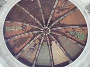
. The roof covering the cistern has paintings depicting Indian maidens carrying water vessels. The temple is open to the public Monday to Friday, 9:00 am to 3:00 pm.
History
William Bowers Bourn II
William Bowers Bourn II was an American entrepreneur and builder of Filoli the country estate in San Mateo County, California.-Biography:...
, a major stockholder in the SVWC, and owner of the giant Empire gold mine
Empire Mine State Historic Park
Empire Mine State Historic Park is a state-protected mine and park in the Sierra Nevada Mountains in Grass Valley, California. The Empire Mine is on the National Register of Historic Places and a federal Historic District. Since 1975, California State Parks has administered and maintained the mine...
, hired Willis Polk to design a "water temple" atop the spot where three subterranean water sources converge (a pipe from the Arroyo de la Laguna
Arroyo de la Laguna
Arroyo de la Laguna is a southward-flowing stream in Alameda County, California, USA which originates at the confluences of South San Ramon Creek and Arroyo Mocho. The Arroyo de la Laguna is fed by tributaries in the Amador Valley and certain eastern slope drainages of the Diablo Range; these...
, Alameda Creek
Alameda Creek
Alameda Creek is a large perennial stream in the San Francisco Bay Area. The creek runs for from a lake northeast of Packard Ridge to the eastern shore San Francisco Bay by way of Niles Canyon and a flood control channel.-History:...
, through the Sunol infiltration galleries
Infiltration gallery
An infiltration gallery is a structure including perforated conduits in gravel to expedite transfer of water to or from a soil aquifer.-Storm water disposal:...
, and a 30-inch pipeline from the artesian well field of Pleasanton
Pleasanton, California
Pleasanton is a city in Alameda County, California, incorporated in 1894. It is a suburb in the San Francisco Bay Area located about east of Oakland, and west of Livermore. The population was 70,285 at the 2010 census. In 2005 and 2007, Pleasanton was ranked the wealthiest middle-sized city in...
) Some sources claim Bourn wanted to sell the water company to the City of San Francisco and saw the temple as a way to appeal to San Francisco voters, who would have to approve the purchase (municipal efforts to buy out the SVWC had been a source of constant controversy from as early as 1873, when the first attempt to purchase it was turned down by the voters because the price was too high). Other sources claim that as one born into wealth and classically educated, Bourn was partially motivated by a sense of civic responsibility.
Polk's design, modeled after the ancient Temple of Vesta
Temple of Vesta, Tivoli
The "Temple of Vesta" is a Roman temple in Tivoli, Italy, dating to the early 1st century BC. Its ruins sit on the acropolis of the city, overlooking the falls of the Aniene that are now included in the Villa Gregoriana....
in Tivoli, Italy
Tivoli, Italy
Tivoli , the classical Tibur, is an ancient Italian town in Lazio, about 30 km east-north-east of Rome, at the falls of the Aniene river where it issues from the Sabine hills...
, was constructed in 1910 (Tivoli is where much of the waters that fed Rome
Rome
Rome is the capital of Italy and the country's largest and most populated city and comune, with over 2.7 million residents in . The city is located in the central-western portion of the Italian Peninsula, on the Tiber River within the Lazio region of Italy.Rome's history spans two and a half...
converged in the foothills of the Apennines
Apennine mountains
The Apennines or Apennine Mountains or Greek oros but just as often used alone as a noun. The ancient Greeks and Romans typically but not always used "mountain" in the singular to mean one or a range; thus, "the Apennine mountain" refers to the entire chain and is translated "the Apennine...
). Prior to the construction to the Hetch Hetchy Aqueduct
Hetch Hetchy Aqueduct
The Hetch Hetchy Aqueduct is a conveyance of Tuolumne River water runoff from federal lands in Yosemite National Park to San Francisco and its client municipalities in the greater San Francisco Bay Area...
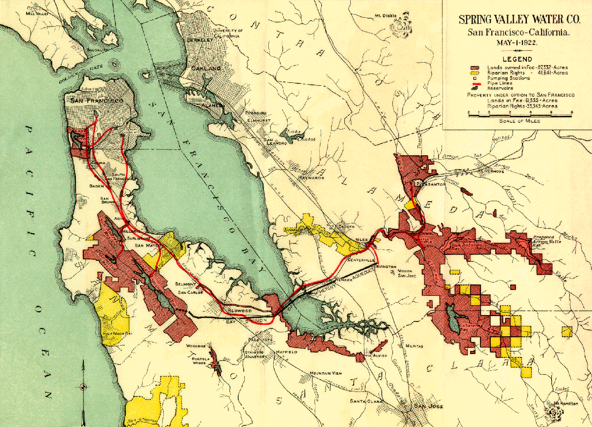
, half of San Francisco's water supply (6 million gallons a day) passed through the Sunol temple. The SVWC, including the temple, was purchased by San Francisco in 1930 for $40 million.
For decades the Water Temple received many visitors and was a popular location for picnic
Picnic
In contemporary usage, a picnic can be defined simply as a pleasure excursion at which a meal is eaten outdoors , ideally taking place in a beautiful landscape such as a park, beside a lake or with an interesting view and possibly at a public event such as before an open air theatre performance,...
kers. By the 1980s the water temple had badly deteriorated, and was severely damaged in 1989's Loma Prieta earthquake
Loma Prieta earthquake
The Loma Prieta earthquake, also known as the Quake of '89 and the World Series Earthquake, was a major earthquake that struck the San Francisco Bay Area of California on October 17, 1989, at 5:04 p.m. local time...
, leading some community leaders to call for its demolition. The site was closed to the public because of safety concerns. A community effort led to the temple's restoration from 1997 to 2001, at a cost of $1.2 million, including seismic and accessibility upgrades. Following its restoration the temple opened again to the public. Today any water that flows through the temple is not part of the potable water supply.
Fields adjacent to the temple belong to the city of San Francisco which has authorized the digging of a gravel
Gravel
Gravel is composed of unconsolidated rock fragments that have a general particle size range and include size classes from granule- to boulder-sized fragments. Gravel can be sub-categorized into granule and cobble...
quarry
Quarry
A quarry is a type of open-pit mine from which rock or minerals are extracted. Quarries are generally used for extracting building materials, such as dimension stone, construction aggregate, riprap, sand, and gravel. They are often collocated with concrete and asphalt plants due to the requirement...
on the site. Local residents concerned about the temple's future brought a lawsuit to attempt block the quarry project, but eventually ran out of funds and dropped the suit.
In June 2006, a new facility named the Sunol Water Temple Agricultural Park was opened on a site adjacent to the temple. The park provides space for small businesses and nonprofit groups to grow produce
Produce
Produce is a generalized term for a group of farm-produced goods and, not limited to fruits and vegetables . More specifically, the term "produce" often implies that the products are fresh and generally in the same state as where they were harvested. In supermarkets the term is also used to refer...
. The park serves a platform for service and educational programs related to sustainable agriculture
Sustainable agriculture
Sustainable agriculture is the practice of farming using principles of ecology, the study of relationships between organisms and their environment...
and environmental conservation.
Inscription
"I will make the wilderness a pool of water and the dry lands springs of water. [] The streams whereof shall make glad the city. [] S.V.W.C. MCMX [Spring Valley Water Company 1910]"See also
- Pulgas Water TemplePulgas Water TempleThe Pulgas Water Temple is a stone structure in Woodside, California, USA, designed by architect William G. Merchant. It was erected by the San Francisco Water Department to commemorate the 1934 completion of the Hetch Hetchy Aqueduct and is located at the aqueduct's terminus...
, a similar structure on the San Francisco PeninsulaSan Francisco PeninsulaThe San Francisco Peninsula is a peninsula in the San Francisco Bay Area that separates the San Francisco Bay from the Pacific Ocean. On its northern tip is the City and County of San Francisco. Its southern base is in Santa Clara County, including the cities of Palo Alto, Los Altos, and Mountain...
, opened in 1934 to commemorate the completion of the Hetch Hetchy AqueductHetch Hetchy AqueductThe Hetch Hetchy Aqueduct is a conveyance of Tuolumne River water runoff from federal lands in Yosemite National Park to San Francisco and its client municipalities in the greater San Francisco Bay Area...
.
External links
- Chronological listing of selected extant Polk-designed structures in the Bay Area
- Save Our Sunol, a community group that organized support for the temple's restoration
- Images of the Water Temple
- Sunol Water Temple Agricultural Park