
.gif)
Dumbarton Bridge (California)
Encyclopedia
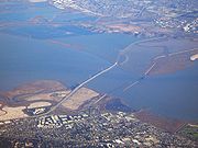
The Dumbarton Bridge is the southernmost of the highway bridge
s that span the San Francisco Bay
in California
. Carrying over 81,000 vehicles daily, it is also the shortest bridge across San Francisco Bay at 1.63 miles (8,600 feet / 2,622 m). Its eastern terminus is in Fremont
, near Newark
in the San Francisco Bay National Wildlife Refuge, and its western terminus is in Menlo Park
. The bridge has three lanes in each direction, and features a separated bike/pedestrian lane on its south-facing side. Like the San Mateo Bridge to the north, power line
s parallel the bridge across the bay.
Tolls are collected in the westbound direction at the toll plaza, which is located on the eastern side of the bay; the toll is $5 as of 7/1/10. There are six toll lanes at the plaza; the leftmost two are dedicated FasTrak
lanes. An additional carpool
lane to the left of these can be used only for half off by vehicles using FasTrak
during weekday morning and afternoon commute hours by vehicles carrying two or more persons, motorcycles, or hybrid vehicles with a permit decal.
 When the current bridge was planned in the 1970s, Caltrans conducted extensive environmental research on the aquatic
and terrestrial
environment. Principal concerns of the public were air pollution
and noise pollution
impacts, particularly in some residential areas of Menlo Park and East Palo Alto. Studies were conducted to produce contour maps of projected sound levels and carbon monoxide
concentrations throughout the western approaches, for each alternative connection scheme.
The local area around the bridge is an important ecological area, hosting many species of birds, fish and mammals. The endangered species
California clapper rail
is known to be present in the western bridge terminus area.
Near the bridge on the Peninsula are Menlo Park's Bayfront Park, East Palo Alto's Ravenswood Open Space Preserve, and Palo Alto's Baylands Nature Preserve. An accessible portion of the San Francisco Bay National Wildlife Refuge lies immediately north of the western bridge terminus, where the Ravenswood trail runs.
On both sides of the eastern terminus of the bridge are large salt ponds and levee
trails belonging to the Don Edwards San Francisco Bay National Wildlife Refuge
. The headquarters and visitor center for the refuge is on a hill south of the bridge approach. North of the eastern bridge terminus is Coyote Hills Regional Park
, with its network of trails running over tall hills. North of that is the Alameda Creek Regional Trail, running from the Bay to Niles Canyon
. East of Coyote Hills
is Ardenwood Historic Farm
, a restored working farm that preserves and displays turn-of-the-century farming methods
. Built originally to provide a shortcut for traffic originating in San Mateo and Santa Clara Counties, the bridge served industrial and residential areas on both sides. The earlier bridge, opened on January 17, 1927, was the first vehicular bridge to cross San Francisco Bay. Portions of this old drawbridge remain as fishing piers. The original bridge was built with private capital and then purchased by the State for $2.5 million in 1951.
Its age and the limitations of a two-lane undivided roadway and lift-span made it necessary for a replacement bridge to be constructed to the north. This current bridge, a six-lane, high-level structure, was opened to traffic in October 1982. The cost of the complete replacement project was $200 million. The current bridge includes a two-way bicycle
and separate pedestrian path on the south-facing side. A 340 ft (104 m) center span provides 85 ft (26 m) of vertical clearance for ship
ping. The approach spans on both sides of the Bay are of pre-stressed lightweight concrete girder
s supporting a lightweight concrete deck. The center spans are twin steel trapezoidal girders which also support a lightweight concrete deck. The center span of the original bridge was demolished in a controlled explosion in September 1984.
, and is directly connected to Interstate 880 by a freeway segment north of the Fremont end.
There is no freeway connection between U.S. 101 and the southwest end of the Dumbarton Bridge. Motorists must traverse one of three at-grade routes to connect from the Bayshore Freeway to the bridge. These are (from northwest to southeast):
Access to I-280 may be gained by Woodside Road
(as signed) or there are other ways corresponding to the above; there is no freeway connection other than using CA 92 or CA 85 instead.
Although the present situation has resulted in severe traffic problems on the bridge itself and in Menlo Park and East Palo Alto, Caltrans has been unable to upgrade the relevant portion of Highway 84 to freeway standards for several decades, due to opposition from the cities of Menlo Park, Atherton and Palo Alto
. Freeway opponents fear that upgrading Highway 84 will encourage more people to live in Alameda County
(where housing is more affordable) and commute to jobs in the mid-Peninsula area (where businesses wish to be located in order to be close to Silicon Valley
), thus increasing traffic in their neighborhoods to the south and west of U.S. 101.
Bus service across the bridge is provided by the Dumbarton Express
, run by a consortium of local transit agencies (SamTrans
, AC Transit
, VTA
and others) which connects to BART
at Union City and Caltrain
at Palo Alto and California Avenue. AC Transit also runs the Transbay buses U (Fremont BART
and Amtrak
to Stanford
) and DA (Ardenwood to Oracle and Sun headquarters) across the bridge.
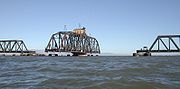 Just to the south of the car bridge lies the Dumbarton Rail Bridge. Built in 1910, the rail bridge has been unused since 1982 and its western approach collapsed in a fire in 1998. When in use, boaters would signal the bridge operator who would start a diesel engine and rotate the bridge to the open position on a large gear. The bridge is now left in the open position as shown. There are plans for a new rail bridge and rehabilitation of the rail line to serve a commuter rail service to connect Union City, Fremont
, and Newark to various Peninsula
destinations. A successful March 2004 regional transportation ballot measure included funding to rehabilitate the rail bridge for the commuter rail service, but in October 2008 the Metropolitan Transportation Commission transferred $91 million from this project to the BART Warm Springs Extension Project in Fremont.
Between the Dumbarton Bridge and the Dumbarton Rail Bridge is the Bay crossing of the Hetch Hetchy Aqueduct
. The aqueduct rises above ground in Newark at the east side of the Bay, falls below the water's surface at a pump station in Fremont, re-emerges in the middle of the Bay and then continues above water until it reaches the west side of the Bay at Menlo Park.
Bridge
A bridge is a structure built to span physical obstacles such as a body of water, valley, or road, for the purpose of providing passage over the obstacle...
s that span the San Francisco Bay
San Francisco Bay
San Francisco Bay is a shallow, productive estuary through which water draining from approximately forty percent of California, flowing in the Sacramento and San Joaquin rivers from the Sierra Nevada mountains, enters the Pacific Ocean...
in California
California
California is a state located on the West Coast of the United States. It is by far the most populous U.S. state, and the third-largest by land area...
. Carrying over 81,000 vehicles daily, it is also the shortest bridge across San Francisco Bay at 1.63 miles (8,600 feet / 2,622 m). Its eastern terminus is in Fremont
Fremont, California
Fremont is a city in Alameda County, California. It was incorporated on January 23, 1956, from the merger of five smaller communities: Centerville, Niles, Irvington, Mission San Jose, and Warm Springs...
, near Newark
Newark, California
Newark is a city in Alameda County, California, United States. It was incorporated as a city in September 1955. Newark is an enclave, completely surrounded by the city of Fremont. Its population was 42,573 at the 2010 census.-Geography:...
in the San Francisco Bay National Wildlife Refuge, and its western terminus is in Menlo Park
Menlo Park, California
Menlo Park, California is a city at the eastern edge of San Mateo County, in the San Francisco Bay Area of California, in the United States. It is bordered by San Francisco Bay on the north and east; East Palo Alto, Palo Alto, and Stanford to the south; Atherton, North Fair Oaks, and Redwood City...
. The bridge has three lanes in each direction, and features a separated bike/pedestrian lane on its south-facing side. Like the San Mateo Bridge to the north, power line
Electric power transmission
Electric-power transmission is the bulk transfer of electrical energy, from generating power plants to Electrical substations located near demand centers...
s parallel the bridge across the bay.
Tolls are collected in the westbound direction at the toll plaza, which is located on the eastern side of the bay; the toll is $5 as of 7/1/10. There are six toll lanes at the plaza; the leftmost two are dedicated FasTrak
FasTrak
FasTrak is the electronic toll collection system used in the state of California in the United States. The system is used statewide on all of the toll roads, toll bridges, and high occupancy/toll and express toll lanes along the California Freeway and Expressway System.As with other ETC systems,...
lanes. An additional carpool
Carpool
Carpooling , is the sharing of car journeys so that more than one person travels in a car....
lane to the left of these can be used only for half off by vehicles using FasTrak
FasTrak
FasTrak is the electronic toll collection system used in the state of California in the United States. The system is used statewide on all of the toll roads, toll bridges, and high occupancy/toll and express toll lanes along the California Freeway and Expressway System.As with other ETC systems,...
during weekday morning and afternoon commute hours by vehicles carrying two or more persons, motorcycles, or hybrid vehicles with a permit decal.
Environmental factors
Marine biology
Marine biology is the scientific study of organisms in the ocean or other marine or brackish bodies of water. Given that in biology many phyla, families and genera have some species that live in the sea and others that live on land, marine biology classifies species based on the environment rather...
and terrestrial
Landform
A landform or physical feature in the earth sciences and geology sub-fields, comprises a geomorphological unit, and is largely defined by its surface form and location in the landscape, as part of the terrain, and as such, is typically an element of topography...
environment. Principal concerns of the public were air pollution
Air pollution
Air pollution is the introduction of chemicals, particulate matter, or biological materials that cause harm or discomfort to humans or other living organisms, or cause damage to the natural environment or built environment, into the atmosphere....
and noise pollution
Noise pollution
Noise pollution is excessive, displeasing human, animal or machine-created environmental noise that disrupts the activity or balance of human or animal life...
impacts, particularly in some residential areas of Menlo Park and East Palo Alto. Studies were conducted to produce contour maps of projected sound levels and carbon monoxide
Carbon monoxide
Carbon monoxide , also called carbonous oxide, is a colorless, odorless, and tasteless gas that is slightly lighter than air. It is highly toxic to humans and animals in higher quantities, although it is also produced in normal animal metabolism in low quantities, and is thought to have some normal...
concentrations throughout the western approaches, for each alternative connection scheme.
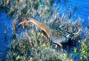
The local area around the bridge is an important ecological area, hosting many species of birds, fish and mammals. The endangered species
Endangered species
An endangered species is a population of organisms which is at risk of becoming extinct because it is either few in numbers, or threatened by changing environmental or predation parameters...
California clapper rail
California Clapper Rail
The California Clapper Rail is an endangered subspecies of the Clapper Rail . It is found principally in California's San Francisco Bay, and also in Monterey Bay and Morro Bay...
is known to be present in the western bridge terminus area.
Near the bridge on the Peninsula are Menlo Park's Bayfront Park, East Palo Alto's Ravenswood Open Space Preserve, and Palo Alto's Baylands Nature Preserve. An accessible portion of the San Francisco Bay National Wildlife Refuge lies immediately north of the western bridge terminus, where the Ravenswood trail runs.
On both sides of the eastern terminus of the bridge are large salt ponds and levee
Levee
A levee, levée, dike , embankment, floodbank or stopbank is an elongated naturally occurring ridge or artificially constructed fill or wall, which regulates water levels...
trails belonging to the Don Edwards San Francisco Bay National Wildlife Refuge
Don Edwards San Francisco Bay National Wildlife Refuge
Don Edwards San Francisco Bay National Wildlife Refuge is a US National Wildlife Refuge located in the southern part of San Francisco Bay, California. The Refuge headquarters and visitor center is located in the Baylands district of Fremont, next to Coyote Hills Regional Park, in Alameda County. ...
. The headquarters and visitor center for the refuge is on a hill south of the bridge approach. North of the eastern bridge terminus is Coyote Hills Regional Park
Coyote Hills Regional Park
Coyote Hills Regional Park is a regional park encompassing nearly 978 acres of land and administered by the East Bay Regional Park District. The park, which was dedicated to public use in 1967, is located in Fremont, California, on the southeast shore of the San Francisco Bay...
, with its network of trails running over tall hills. North of that is the Alameda Creek Regional Trail, running from the Bay to Niles Canyon
Niles Canyon
Niles Canyon is a canyon in the San Francisco Bay Area formed by Alameda Creek. The canyon is largely in an unincorporated area of Alameda County, while the western portion of the canyon lies within the city limits of Fremont and Union City...
. East of Coyote Hills
Coyote Hills
Coyote Hills may refer to:* Coyote Hills , California, USA** Coyote Hills Regional Park* Coyote Hills , California, USA* Coyote Hills, Baker County, Oregon, USARelated names include...
is Ardenwood Historic Farm
Ardenwood Historic Farm
Ardenwood Historic Farm is a Regional Historic Landmark in Fremont, California.-Description:Officially opened to the public on July 28, 1985, the entire park includes a farm, a large forest and a mansion now called the Patterson House which was first constructed in 1857 by the farm's original...
, a restored working farm that preserves and displays turn-of-the-century farming methods
History and engineering features
The bridge never was officially named, but the common use name comes from Dumbarton Point, which dates to 1876 when it was named for Dumbarton in ScotlandScotland
Scotland is a country that is part of the United Kingdom. Occupying the northern third of the island of Great Britain, it shares a border with England to the south and is bounded by the North Sea to the east, the Atlantic Ocean to the north and west, and the North Channel and Irish Sea to the...
. Built originally to provide a shortcut for traffic originating in San Mateo and Santa Clara Counties, the bridge served industrial and residential areas on both sides. The earlier bridge, opened on January 17, 1927, was the first vehicular bridge to cross San Francisco Bay. Portions of this old drawbridge remain as fishing piers. The original bridge was built with private capital and then purchased by the State for $2.5 million in 1951.
Its age and the limitations of a two-lane undivided roadway and lift-span made it necessary for a replacement bridge to be constructed to the north. This current bridge, a six-lane, high-level structure, was opened to traffic in October 1982. The cost of the complete replacement project was $200 million. The current bridge includes a two-way bicycle
Bicycle
A bicycle, also known as a bike, pushbike or cycle, is a human-powered, pedal-driven, single-track vehicle, having two wheels attached to a frame, one behind the other. A person who rides a bicycle is called a cyclist, or bicyclist....
and separate pedestrian path on the south-facing side. A 340 ft (104 m) center span provides 85 ft (26 m) of vertical clearance for ship
Ship
Since the end of the age of sail a ship has been any large buoyant marine vessel. Ships are generally distinguished from boats based on size and cargo or passenger capacity. Ships are used on lakes, seas, and rivers for a variety of activities, such as the transport of people or goods, fishing,...
ping. The approach spans on both sides of the Bay are of pre-stressed lightweight concrete girder
Girder
A girder is a support beam used in construction. Girders often have an I-beam cross section for strength, but may also have a box shape, Z shape or other forms. Girder is the term used to denote the main horizontal support of a structure which supports smaller beams...
s supporting a lightweight concrete deck. The center spans are twin steel trapezoidal girders which also support a lightweight concrete deck. The center span of the original bridge was demolished in a controlled explosion in September 1984.
Connections to the western system
The bridge is part of State Route 84California State Route 84
State Route 84 is a split-section California State Highway consisting of two sections. The first section is an east–west arterial road running from San Gregorio to Menlo Park, across the Dumbarton Bridge through Fremont and Newark and ending at I-580 in Livermore. The route overlaps the...
, and is directly connected to Interstate 880 by a freeway segment north of the Fremont end.
There is no freeway connection between U.S. 101 and the southwest end of the Dumbarton Bridge. Motorists must traverse one of three at-grade routes to connect from the Bayshore Freeway to the bridge. These are (from northwest to southeast):
- the Bayfront Expressway, a limited-access roadLimited-access roadA limited-access road known by various terms worldwide, including limited-access highway, dual-carriageway and expressway, is a highway or arterial road for high-speed traffic which has many or most characteristics of a controlled-access highway , including limited or no access to adjacent...
linking to U.S. 101 at Marsh Road, AthertonAtherton, CaliforniaAtherton is an incorporated town in San Mateo County, California, United States. Its population was 6,914 at the 2010 census. In September 2010, Forbes magazine placed Atherton's zip code of 94027 at #2 on its annual list of America's most expensive zip codes, with a median home price of $4,010,200...
(the official routing of SR 84) - Willow Road (SR 114California State Route 114State Route 114 is a short state highway in the U.S. state of California that runs between U.S. Route 101 and State Route 84 in East Palo Alto and Menlo Park...
), an approximately one-mile expressway through east Menlo Park to U.S. 101 - University Avenue (SR 109California State Route 109State Route 109 is a short, unsigned state highway in the U.S. state of California. It is the portion of University Avenue that runs between U.S. Route 101 and State Route 84 in East Palo Alto and Menlo Park. The route is unsigned; however, it is noted on programs like Yahoo Maps.-Route...
), an arterial roadArterial roadAn arterial road, or arterial thoroughfare, is a high-capacity urban road. The primary function of an arterial road is to deliver traffic from collector roads to freeways, and between urban centres at the highest level of service possible. As such, many arteries are limited-access roads, or feature...
and the main commercial street of East Palo AltoEast Palo Alto, CaliforniaEast Palo Alto is a city in San Mateo County, California, United States.-Overview:As of the 2010 census, the population of East Palo Alto was 28,155. It is situated on the San Francisco Peninsula, roughly halfway between the cities of San Francisco and San Jose...
.
Access to I-280 may be gained by Woodside Road
Woodside Road
Woodside Road is a football stadium in Worthing, West Sussex, England. First opened in 1892, it is the home of Worthing F.C. and has a capacity of 4,000.-History:...
(as signed) or there are other ways corresponding to the above; there is no freeway connection other than using CA 92 or CA 85 instead.
Although the present situation has resulted in severe traffic problems on the bridge itself and in Menlo Park and East Palo Alto, Caltrans has been unable to upgrade the relevant portion of Highway 84 to freeway standards for several decades, due to opposition from the cities of Menlo Park, Atherton and Palo Alto
Palo Alto, California
Palo Alto is a California charter city located in the northwest corner of Santa Clara County, in the San Francisco Bay Area of California, United States. The city shares its borders with East Palo Alto, Mountain View, Los Altos, Los Altos Hills, Stanford, Portola Valley, and Menlo Park. It is...
. Freeway opponents fear that upgrading Highway 84 will encourage more people to live in Alameda County
Alameda County, California
Alameda County is a county in the U.S. state of California. It occupies most of the East Bay region of the San Francisco Bay Area. As of the 2010 census it had a population of 1,510,271, making it the 7th most populous county in the state...
(where housing is more affordable) and commute to jobs in the mid-Peninsula area (where businesses wish to be located in order to be close to Silicon Valley
Silicon Valley
Silicon Valley is a term which refers to the southern part of the San Francisco Bay Area in Northern California in the United States. The region is home to many of the world's largest technology corporations...
), thus increasing traffic in their neighborhoods to the south and west of U.S. 101.
Bus service across the bridge is provided by the Dumbarton Express
Dumbarton Express
The Dumbarton Express is a California bus service operating between Union City BART station and Palo Alto Caltrain station via the Dumbarton Bridge. The service is operated by a group of operators including BART, VTA, Union City Transit, and AC Transit...
, run by a consortium of local transit agencies (SamTrans
SamTrans
SamTrans is a public transport agency in and around San Mateo, California, in the San Francisco Bay Area. It provides bus service throughout San Mateo County and into portions of San Francisco and Palo Alto...
, AC Transit
AC Transit
AC Transit is an Oakland-based regional public transit agency serving the western half of Alameda County and parts of western Contra Costa County in the western, Bay-side area of the East Bay of the San Francisco Bay Area...
, VTA
Santa Clara Valley Transportation Authority
The Santa Clara Valley Transportation Authority is a special-purpose district responsible for public transit services, congestion management, specific highway improvement projects, and countywide transportation planning for Santa Clara County, California, United States...
and others) which connects to BART
Bay Area Rapid Transit
Bay Area Rapid Transit is a rapid transit system serving the San Francisco Bay Area. The heavy-rail public transit and subway system connects San Francisco with cities in the East Bay and suburbs in northern San Mateo County. BART operates five lines on of track with 44 stations in four counties...
at Union City and Caltrain
Caltrain
Caltrain is a California commuter rail line on the San Francisco Peninsula and in the Santa Clara Valley in the United States. The northern terminus of the rail line is in San Francisco, at 4th and King streets; its southern terminus is in Gilroy...
at Palo Alto and California Avenue. AC Transit also runs the Transbay buses U (Fremont BART
Fremont (BART station)
Fremont is a Bay Area Rapid Transit station that serves Fremont, California. The elevated island platform serves as the southernmost terminal station of BART's Fremont line, which is served by trains on the Fremont - Daly City Line, which runs daytimes Monday-Saturday, and the Richmond - Fremont...
and Amtrak
Fremont-Centerville (Amtrak station)
-Rail Service:*The Altamont Commuter Express serves the station on weekdays.*Amtrak's Capitol Corridor stops 14 times daily, with seven trains in each direction....
to Stanford
Stanford University
The Leland Stanford Junior University, commonly referred to as Stanford University or Stanford, is a private research university on an campus located near Palo Alto, California. It is situated in the northwestern Santa Clara Valley on the San Francisco Peninsula, approximately northwest of San...
) and DA (Ardenwood to Oracle and Sun headquarters) across the bridge.
Dumbarton Rail Bridge
Fremont, California
Fremont is a city in Alameda County, California. It was incorporated on January 23, 1956, from the merger of five smaller communities: Centerville, Niles, Irvington, Mission San Jose, and Warm Springs...
, and Newark to various Peninsula
San Francisco Peninsula
The San Francisco Peninsula is a peninsula in the San Francisco Bay Area that separates the San Francisco Bay from the Pacific Ocean. On its northern tip is the City and County of San Francisco. Its southern base is in Santa Clara County, including the cities of Palo Alto, Los Altos, and Mountain...
destinations. A successful March 2004 regional transportation ballot measure included funding to rehabilitate the rail bridge for the commuter rail service, but in October 2008 the Metropolitan Transportation Commission transferred $91 million from this project to the BART Warm Springs Extension Project in Fremont.
Between the Dumbarton Bridge and the Dumbarton Rail Bridge is the Bay crossing of the Hetch Hetchy Aqueduct
Hetch Hetchy Aqueduct
The Hetch Hetchy Aqueduct is a conveyance of Tuolumne River water runoff from federal lands in Yosemite National Park to San Francisco and its client municipalities in the greater San Francisco Bay Area...
. The aqueduct rises above ground in Newark at the east side of the Bay, falls below the water's surface at a pump station in Fremont, re-emerges in the middle of the Bay and then continues above water until it reaches the west side of the Bay at Menlo Park.
External links
- California Dept. of Transportation: Dumbarton Bridge History & Information
- Bay Trail: Dumbarton Bridge