

Sunol, California
Encyclopedia
Sunol is an unincorporated census-designated place
(CDP) in Alameda County
, California
, United States
. The population was 913 at the 2010 census.
The small, rural town of Sunol located along Niles Canyon is well known for its historic railroad system, on which the tourist railroad Niles Canyon Railway
makes an in-town stop and the Altamont Commuter Express
passes en route to San Jose and the Central Valley.
land grant that once contained the site of the town.
and State Route 84
. These connect Sunol with Fremont to the south and west, Pleasanton to the north, and Livermore to the northeast. Sunol sits 17 miles (27.4 km) north the center of San Jose and 32 miles (51.5 km) southeast of San Francisco.
The town lies near Alameda Creek
at the northwest edge of the Sunol Valley
. The San Antonio Reservoir
lies 3 miles (4.8 km) to Sunol's east, and the Calaveras Reservoir
lies 8 miles (12.9 km) south of the town.
North of the town is the locale of Kilkare Woods
, accessible only through Sunol.
According to the United States Census Bureau
, the Sunol CDP has a total area of 27.8 square miles (72 km²), of which 99.95% is land and 0.05% is water.
was 32.9 people per square mile (12.7/km²). The racial makeup of Sunol was 780 (85.4%) White, 1 (0.1%) African American, 6 (0.7%) Native American, 48 (5.3%) Asian, 7 (0.8%) Pacific Islander, 19 (2.1%) from other races
, and 52 (5.7%) from two or more races. Hispanic or Latino of any race were 91 persons (10.0%).
The Census reported that 100% of the population lived in households.
There were 362 households, out of which 76 (21.0%) had children under the age of 18 living in them, 228 (63.0%) were opposite-sex married couples
living together, 20 (5.5%) had a female householder with no husband present, 9 (2.5%) had a male householder with no wife present. There were 16 (4.4%) unmarried opposite-sex partnerships
, and 5 (1.4%) same-sex married couples or partnerships. 81 households (22.4%) were made up of individuals and 24 (6.6%) had someone living alone who was 65 years of age or older. The average household size was 2.52. There were 257 families
(71.0% of all households); the average family size was 2.90.
The population was spread out with 148 people (16.2%) under the age of 18, 74 people (8.1%) aged 18 to 24, 164 people (18.0%) aged 25 to 44, 377 people (41.3%) aged 45 to 64, and 150 people (16.4%) who were 65 years of age or older. The median age was 49.3 years. For every 100 females there were 101.1 males. For every 100 females age 18 and over, there were 100.8 males.
There were 394 housing units at an average density of 14.2 per square mile (5.5/km²), of which 272 (75.1%) were owner-occupied, and 90 (24.9%) were occupied by renters. The homeowner vacancy rate was 1.1%; the rental vacancy rate was 4.1%. 708 people (77.5% of the population) lived in owner-occupied housing units and 205 people (22.5%) lived in rental housing units.
of 2000, there were 1,332 people, 483 households, and 368 families residing in the CDP. The population density
was 40.6 people per square mile (15.7/km²). There were 503 housing units at an average density of 15.3 per square mile (5.9/km²). The racial makeup of the CDP was 84.46% White
, 0.98% Native American
, 4.80% Asian
, 0.23% Pacific Islander
, 4.13% from other races
, and 5.41% from two or more races. 8.71% of the population were Hispanic
or Latino
of any race.
There were 483 households out of which 32.3% had children under the age of 18 living with them, 66.3% were married couples living together, 5.4% had a female householder with no husband present, and 23.8% were non-families. 17.2% of all households were made up of individuals and 4.8% had someone living alone who was 65 years of age or older. The average household size was 2.76 and the average family size was 3.12.
In the CDP the population was 22.7% under the age of 18, 8.2% from 18 to 24, 25.5% from 25 to 44, 33.0% from 45 to 64, and 10.7% who were 65 years of age or older. The median age was 41 years. For every 100 females there were 106.2 males. For every 100 females age 18 and over, there were 104.4 males. The median income for a household in the CDP was $88,353, and the median income for a family was $96,121. Males had a median income of $77,666 versus $37,102 for females. The per capita income
for the CDP was $45,773. None of the families and 1.4% of the population were living below the poverty line, including no under eighteens and none of those over 64.
in nearby Pleasanton.
Census-designated place
A census-designated place is a concentration of population identified by the United States Census Bureau for statistical purposes. CDPs are delineated for each decennial census as the statistical counterparts of incorporated places such as cities, towns and villages...
(CDP) in Alameda County
Alameda County, California
Alameda County is a county in the U.S. state of California. It occupies most of the East Bay region of the San Francisco Bay Area. As of the 2010 census it had a population of 1,510,271, making it the 7th most populous county in the state...
, California
California
California is a state located on the West Coast of the United States. It is by far the most populous U.S. state, and the third-largest by land area...
, United States
United States
The United States of America is a federal constitutional republic comprising fifty states and a federal district...
. The population was 913 at the 2010 census.
The small, rural town of Sunol located along Niles Canyon is well known for its historic railroad system, on which the tourist railroad Niles Canyon Railway
Niles Canyon Railway
The Niles Canyon Railway is a heritage railway running through Niles Canyon, between Sunol and the Niles district of Fremont in the East Bay of the San Francisco Bay Area, in California, USA. The railway is listed on the National Register of Historic Places as the Niles Canyon Transcontinental...
makes an in-town stop and the Altamont Commuter Express
Altamont Commuter Express
The Altamont Commuter Express is a regional rail service in California connecting Stockton with San Jose....
passes en route to San Jose and the Central Valley.
History
The first Sunol post office opened in 1871 and the name was changed to Sunolglen the same year. The name reverted to Sunol in 1920. The town's name is in honor of Antonio Suñol, part owner of the historical Rancho Valle de San JoseRancho Valle de San Jose (Bernal)
Rancho Valle de San José was a Mexican land grant in present day Alameda County, California given in 1839 by Governor Juan Alvarado to Antonio Maria Pico, Agustín Bernal , Juan Pablo Bernal , and María Dolores Bernal de Suñol...
land grant that once contained the site of the town.
Geography
Sunol is located adjacent to two railroads and lies near the crossroads of Interstate 680Interstate 680 (California)
Interstate 680 is a north–south Interstate Highway in Northern California. It curves around the eastern cities of the San Francisco Bay Area from San Jose to Interstate 80 at Cordelia, bypassing cities along the eastern shore of San Francisco Bay such as Oakland and Richmond while serving...
and State Route 84
California State Route 84
State Route 84 is a split-section California State Highway consisting of two sections. The first section is an east–west arterial road running from San Gregorio to Menlo Park, across the Dumbarton Bridge through Fremont and Newark and ending at I-580 in Livermore. The route overlaps the...
. These connect Sunol with Fremont to the south and west, Pleasanton to the north, and Livermore to the northeast. Sunol sits 17 miles (27.4 km) north the center of San Jose and 32 miles (51.5 km) southeast of San Francisco.
The town lies near Alameda Creek
Alameda Creek
Alameda Creek is a large perennial stream in the San Francisco Bay Area. The creek runs for from a lake northeast of Packard Ridge to the eastern shore San Francisco Bay by way of Niles Canyon and a flood control channel.-History:...
at the northwest edge of the Sunol Valley
Sunol Valley
Sunol Valley is located in Alameda County, California, USA. The small town of Sunol lies in the valley. It is largely rural, but is in proximity to the highly populated Bay Area suburbs of Fremont, Pleasanton, and Livermore....
. The San Antonio Reservoir
San Antonio Reservoir (Alameda County)
San Antonio Reservoir is located in Alameda County, California, about three miles east-southeast of Sunol. It was built in 1964 by the City and County of San Francisco. Formed by damming San Antonio Creek not far above where it flows into Alameda Creek, its purpose is to store water from the Hetch...
lies 3 miles (4.8 km) to Sunol's east, and the Calaveras Reservoir
Calaveras Reservoir
Calaveras Reservoir is a lake located primarily in Santa Clara County, California with a small portion and its dam in Alameda County, California. The reservoir has a capacity of . In Spanish, Calaveras means "skulls."...
lies 8 miles (12.9 km) south of the town.
North of the town is the locale of Kilkare Woods
Kilkare Woods, California
Kilkare Woods is a small rural unincorporated community of about 773 people in southern Alameda County, California, near Pleasanton. The town is along Kilkare Road and is in zip code 94586. It lies at an elevation of 827 feet . 96% of residents of the zip code spoke English as their primary...
, accessible only through Sunol.
According to the United States Census Bureau
United States Census Bureau
The United States Census Bureau is the government agency that is responsible for the United States Census. It also gathers other national demographic and economic data...
, the Sunol CDP has a total area of 27.8 square miles (72 km²), of which 99.95% is land and 0.05% is water.
2010 Census data
The 2010 United States Census reported that Sunol had a population of 913. The population densityPopulation density
Population density is a measurement of population per unit area or unit volume. It is frequently applied to living organisms, and particularly to humans...
was 32.9 people per square mile (12.7/km²). The racial makeup of Sunol was 780 (85.4%) White, 1 (0.1%) African American, 6 (0.7%) Native American, 48 (5.3%) Asian, 7 (0.8%) Pacific Islander, 19 (2.1%) from other races
Race (United States Census)
Race and ethnicity in the United States Census, as defined by the Federal Office of Management and Budget and the United States Census Bureau, are self-identification data items in which residents choose the race or races with which they most closely identify, and indicate whether or not they are...
, and 52 (5.7%) from two or more races. Hispanic or Latino of any race were 91 persons (10.0%).
The Census reported that 100% of the population lived in households.
There were 362 households, out of which 76 (21.0%) had children under the age of 18 living in them, 228 (63.0%) were opposite-sex married couples
Marriage
Marriage is a social union or legal contract between people that creates kinship. It is an institution in which interpersonal relationships, usually intimate and sexual, are acknowledged in a variety of ways, depending on the culture or subculture in which it is found...
living together, 20 (5.5%) had a female householder with no husband present, 9 (2.5%) had a male householder with no wife present. There were 16 (4.4%) unmarried opposite-sex partnerships
POSSLQ
POSSLQ is an abbreviation for "Persons of Opposite Sex Sharing Living Quarters," a term coined in the late 1970s by the United States Census Bureau as part of an effort to more accurately gauge the prevalence of cohabitation in American households....
, and 5 (1.4%) same-sex married couples or partnerships. 81 households (22.4%) were made up of individuals and 24 (6.6%) had someone living alone who was 65 years of age or older. The average household size was 2.52. There were 257 families
Family (U.S. Census)
A family or family household is defined by the United States Census Bureau for statistical purposes as "a householder and one or more other people related to the householder by birth, marriage, or adoption. They do not include same-sex married couples even if the marriage was performed in a state...
(71.0% of all households); the average family size was 2.90.
The population was spread out with 148 people (16.2%) under the age of 18, 74 people (8.1%) aged 18 to 24, 164 people (18.0%) aged 25 to 44, 377 people (41.3%) aged 45 to 64, and 150 people (16.4%) who were 65 years of age or older. The median age was 49.3 years. For every 100 females there were 101.1 males. For every 100 females age 18 and over, there were 100.8 males.
There were 394 housing units at an average density of 14.2 per square mile (5.5/km²), of which 272 (75.1%) were owner-occupied, and 90 (24.9%) were occupied by renters. The homeowner vacancy rate was 1.1%; the rental vacancy rate was 4.1%. 708 people (77.5% of the population) lived in owner-occupied housing units and 205 people (22.5%) lived in rental housing units.
2000 Census data
As of the censusCensus
A census is the procedure of systematically acquiring and recording information about the members of a given population. It is a regularly occurring and official count of a particular population. The term is used mostly in connection with national population and housing censuses; other common...
of 2000, there were 1,332 people, 483 households, and 368 families residing in the CDP. The population density
Population density
Population density is a measurement of population per unit area or unit volume. It is frequently applied to living organisms, and particularly to humans...
was 40.6 people per square mile (15.7/km²). There were 503 housing units at an average density of 15.3 per square mile (5.9/km²). The racial makeup of the CDP was 84.46% White
Race (United States Census)
Race and ethnicity in the United States Census, as defined by the Federal Office of Management and Budget and the United States Census Bureau, are self-identification data items in which residents choose the race or races with which they most closely identify, and indicate whether or not they are...
, 0.98% Native American
Race (United States Census)
Race and ethnicity in the United States Census, as defined by the Federal Office of Management and Budget and the United States Census Bureau, are self-identification data items in which residents choose the race or races with which they most closely identify, and indicate whether or not they are...
, 4.80% Asian
Race (United States Census)
Race and ethnicity in the United States Census, as defined by the Federal Office of Management and Budget and the United States Census Bureau, are self-identification data items in which residents choose the race or races with which they most closely identify, and indicate whether or not they are...
, 0.23% Pacific Islander
Race (United States Census)
Race and ethnicity in the United States Census, as defined by the Federal Office of Management and Budget and the United States Census Bureau, are self-identification data items in which residents choose the race or races with which they most closely identify, and indicate whether or not they are...
, 4.13% from other races
Race (United States Census)
Race and ethnicity in the United States Census, as defined by the Federal Office of Management and Budget and the United States Census Bureau, are self-identification data items in which residents choose the race or races with which they most closely identify, and indicate whether or not they are...
, and 5.41% from two or more races. 8.71% of the population were Hispanic
Race (United States Census)
Race and ethnicity in the United States Census, as defined by the Federal Office of Management and Budget and the United States Census Bureau, are self-identification data items in which residents choose the race or races with which they most closely identify, and indicate whether or not they are...
or Latino
Race (United States Census)
Race and ethnicity in the United States Census, as defined by the Federal Office of Management and Budget and the United States Census Bureau, are self-identification data items in which residents choose the race or races with which they most closely identify, and indicate whether or not they are...
of any race.
There were 483 households out of which 32.3% had children under the age of 18 living with them, 66.3% were married couples living together, 5.4% had a female householder with no husband present, and 23.8% were non-families. 17.2% of all households were made up of individuals and 4.8% had someone living alone who was 65 years of age or older. The average household size was 2.76 and the average family size was 3.12.
In the CDP the population was 22.7% under the age of 18, 8.2% from 18 to 24, 25.5% from 25 to 44, 33.0% from 45 to 64, and 10.7% who were 65 years of age or older. The median age was 41 years. For every 100 females there were 106.2 males. For every 100 females age 18 and over, there were 104.4 males. The median income for a household in the CDP was $88,353, and the median income for a family was $96,121. Males had a median income of $77,666 versus $37,102 for females. The per capita income
Per capita income
Per capita income or income per person is a measure of mean income within an economic aggregate, such as a country or city. It is calculated by taking a measure of all sources of income in the aggregate and dividing it by the total population...
for the CDP was $45,773. None of the families and 1.4% of the population were living below the poverty line, including no under eighteens and none of those over 64.
Area attractions
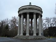
- The Sunol Water TempleSunol Water TempleThe Sunol Water Temple is located at 505 Paloma Way in Sunol, California. Designed by Willis Polk, the 59 foot high classical pavilion is made up of twelve concrete Corinthian columns and a concrete ring girder that supports the conical wood and tile roof...
is an unusual Roman-inspired structure where three water mains converge before being piped to San Francisco. - The Niles Canyon RailwayNiles Canyon RailwayThe Niles Canyon Railway is a heritage railway running through Niles Canyon, between Sunol and the Niles district of Fremont in the East Bay of the San Francisco Bay Area, in California, USA. The railway is listed on the National Register of Historic Places as the Niles Canyon Transcontinental...
Sunol Depot was built in 1884, and is the last surviving example of a Southern Pacific standard design known as a "One-Story Combination Depot #7." The building has been restored and is operated by the Pacific Locomotive AssociationPacific Locomotive AssociationThe Pacific Locomotive Association is an organization dedicated to the preservation of the physical aspects and atmosphere of Pacific Coast railroading during the period from 1910 to 1960....
. - Niles Canyon Road runs westward from Sunol and is a scenic 7 miles (11.3 km) drive to Fremont.
- In 1981, a Labrador retrieverLabrador RetrieverThe Labrador Retriever is one of several kinds of retriever, a type of gun dog. A breed characteristic is webbed paws for swimming, useful for the breed's original purpose of retrieving fishing nets. The Labrador is the most popular breed of dog by registered ownership in Canada, the United...
named Bosco was elected honorary mayor of Sunol, serving until his death in 1994. Bosco achieved a degree of international notoriety in 1990 when the Chinese newspaper The People's Daily reported on his tenure as an alleged example of the failings of the American electoral process. - In 2007, Songwriter Will StrattonWill Stratton-Early life:Will was born in northern California, but raised primarily in New Jersey. He began taking piano lessons at the age of 4. He spent one year at University of Puget Sound studying philosophy, before finishing college at Bennington College, where he switched his studies to music composition...
released a song named after the town on his first album. - Sunol Regional WildernessSunol Regional WildernessThe Sunol Regional Wilderness is a regional park in Alameda County, California, United States that is administered by the East Bay Regional Park District. It is located south of the town of Pleasanton and east of Fremont, near the town of Sunol....
School district
The Sunol Glen School, a kindergarten-through-eighth-grade public school that is also its own school district serves the community of Sunol. High school age children are served by Foothill High SchoolFoothill High School (Pleasanton, California)
Foothill High School is a four-year secondary school in Pleasanton, California. It was built in 1973. It is one of two comprehensive high schools and one alternative high school in the Pleasanton Unified School District. The current enrollment is 2,343 students. The school mascot is the falcon...
in nearby Pleasanton.