
Strathblane
Encyclopedia
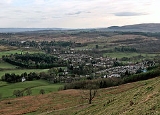
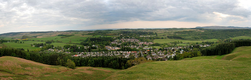
Strathblane is a village and parish in the registration county of Stirlingshire
, situated in the southwestern part of the Stirling council area
, in central Scotland
. It lies at the foothills of the Campsie Fells
and the Kilpatrick Hills
on the Blane Water, 12 miles (19 km) north of Glasgow
, 14 miles (23 km) east-southeast of Dumbarton, and 20 miles (32 km) southwest of Stirling
. Strathblane is a dormitory village for Greater Glasgow
, and has a total resident population of 1,811.
Historically, Strathblane was the name of a parish in Stirlingshire
which comprised three villages: Edenkill, Netherton and Mugdock. Mugdock was the ancient seat of the Earls of Lennox
, and to the east of Strathblane lies the town of Lennoxtown
. Blanefield is a settlement contiguous with Strathblane's northwestern fringe. To the west is the volcanic plug Dumgoyne
, Glengoyne Distillery
and the Trossachs National Park
. The West Highland Way
—a long-distance trail
—passes close to the village.
The Gaelic name Srath Bhlàthain translates to English as "the valley of the Blane", with reference to the Blane Water, a watercourse. The Blane Water (Uisge Bhlàthain) has also been referred to as Beul-abhainn (b̊ialˠ̪a.ɪɲ) meaning "mouth-river" after the numerous burns merging. One of its tributaries, the Ballagan Burn passes over the waterfall the Spout of Ballagan which shows 192 alternate strata
of coloured shale
s and limestone
(including pure alabaster
). The Blane flows into the Endrick, which, in its turn, flows westward to Loch Lomond
.
suggested Strathblane to have been the site of the battle between the Britons and Picts
in the year 750, during which Talorgan son of Fergus, brother of Óengus I of the Picts
, was slain. The Annales Cambriae
and Annals of Ulster
refer to the battle
field as "Mocetauc" or "Catohic" respectively, which Skene and others have suggested referred to Mugdock, a locality at the edge of Lennox
, within the parish of Strathblane.
A rise in population during the early 19th century was due in part to the development of a large calico printfield at Blanefield (employing 78 adults and 45 children under 14) and two bleachfield
s at Dumbrock (employing 67 adults and 14 children under 14) working 10–11 hours per day, 6 days a week. There is no sign of this industry in the village today which has a rural, picturesque aspect while the majority of parishioners now commute to work in neighbouring towns.
of Duntreath who had ancient links to the kings of Scotland. In 1374 Sir John Edmonstone was an ambassador to France
for King Robert II
, subsequently his son Archibald settled the family at Duntreath. In 1425 William Edmonstone married Mary Stewart, Princess of Scotland (second daughter of Robert III
). More recently Edward VII's mistress Alice Keppel
(née Alice Frederica Edmonstone) was the eighth daughter of the 4th baronet.
, which was an administative county
until local government reorganisation in 1975. From 1975 to 1996 it was part of the Central
region of Scotland
. Since 1996, Strathblane has formed part of the Stirling council area.
For elections to Stirling Council, Strathblane is part of the Forth and Endrick ward. The ward returns three councillors under a system of proportional representation
. At the 2007 elections
one councillor each from the Conservative, Labour and Scottish National
Parties.
Strathblane community council represents the villages of Strathblane, Blanefield and Mugdock.
, on the River Blane, 265 feet (81 m) above sea level
. The prevailing rock of Strathblane's hills is basalt
, and that of its lowlands Old Red Sandstone
. The soil is sand
y in the upper part of the valley, and clay
ey in the lower.
The population of the Parish was 620 in 1795, the 1871 census reported 1,235 which had grown to 1,811 by the time of the 2001 census
.
The parish was formerly connected to Glasgow via Edinburgh and Glasgow Railway
and the Blane Valley Railway
, with stations at Campsie Glen, Strathblane, Blanefield, Dumgoyne and Killearn, which opened in 1867 (extended to Aberfoyle in 1882). However, the line became uncompetitive with the growth of road transport, and closed to passengers in 1951 and to freight in 1959.
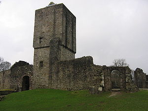 Mugdock Castle
was the stronghold of the Clan Graham
from the middle of the 13th century. Its ruins are located in Mugdock Country Park
at Strathblane's southern extremity with Milngavie
.
The Stirling Observer dated 25 August 1921 reported the unveiling of "a monument erected in memory of those..[25 men of Strathblane]... who fell in the Great War" by the Duke of Montrose
and Sir Archibald Edmonstone
, whose family seat was Duntreath Castle by Blanefield. The monument was designed by Robert Lorimer
and was constructed of Doddington stone. It consists of a square base, each side being panelled to receive the inscriptions and names, a "slender shaft" rises from the base, and at the top of the shaft are four shields, the finish being a cross.
The Duke of Montrose in unveiling the monument paid tribute to the sacrifice made by those from the parish who had died for their country. He said "what the war had meant to those who took part in it, and what their sacrifice meant to those who had benefited by their death, and what it ought to mean to the people of our land as an incentive to noble and self sacrificing lives."
Strathblane Parish Church is a Church of Scotland
, part of the Presbytery of Stirling, and Synod of Forth. There is also a Catholic Church dedicated to St. Kessog.
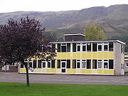 Strathblane Primary School is the local primary school.
.
James Gordon, Baron Gordon of Strathblane
is a businessman and manager granted a Life Peerage granted the territorial qualification of Deil's Craig in Stirling.
,
Stirlingshire
Stirlingshire or the County of Stirling is a registration county of Scotland, based around Stirling, the former county town. It borders Perthshire to the north, Clackmannanshire and West Lothian to the east, Lanarkshire to the south, and Dunbartonshire to the south-west.Until 1975 it was a county...
, situated in the southwestern part of the Stirling council area
Stirling (council area)
Stirling is one of the 32 unitary local government council areas of Scotland, and has a population of about 87,000 . It was created under the Local Government etc Act 1994 with the boundaries of the Stirling district of the former Central local government region, and it covers most of the former...
, in central Scotland
Scotland
Scotland is a country that is part of the United Kingdom. Occupying the northern third of the island of Great Britain, it shares a border with England to the south and is bounded by the North Sea to the east, the Atlantic Ocean to the north and west, and the North Channel and Irish Sea to the...
. It lies at the foothills of the Campsie Fells
Campsie Fells
The Campsie Fells are a range of hills in central Scotland, stretching east to west, from Denny Muir to Dumgoyne, in Stirlingshire. . The highest point in the range is Earl's Seat which is 578 m high...
and the Kilpatrick Hills
Kilpatrick Hills
The Kilpatrick Hills are a range of hills in central Scotland, stretching from Dumbarton in the west to Strathblane in the east. Strathblane divides the Kilpatricks from the Campsie Fells to the east, while to the north is part of the Loch Lomond and the Trossachs National Park...
on the Blane Water, 12 miles (19 km) north of Glasgow
Glasgow
Glasgow is the largest city in Scotland and third most populous in the United Kingdom. The city is situated on the River Clyde in the country's west central lowlands...
, 14 miles (23 km) east-southeast of Dumbarton, and 20 miles (32 km) southwest of Stirling
Stirling
Stirling is a city and former ancient burgh in Scotland, and is at the heart of the wider Stirling council area. The city is clustered around a large fortress and medieval old-town beside the River Forth...
. Strathblane is a dormitory village for Greater Glasgow
Greater Glasgow
Greater Glasgow is an urban settlement in Scotland consisting of all localities which are physically attached to the city of Glasgow, forming with it a single contiguous urban area...
, and has a total resident population of 1,811.
Historically, Strathblane was the name of a parish in Stirlingshire
Stirlingshire
Stirlingshire or the County of Stirling is a registration county of Scotland, based around Stirling, the former county town. It borders Perthshire to the north, Clackmannanshire and West Lothian to the east, Lanarkshire to the south, and Dunbartonshire to the south-west.Until 1975 it was a county...
which comprised three villages: Edenkill, Netherton and Mugdock. Mugdock was the ancient seat of the Earls of Lennox
Earl of Lennox
The Mormaer of Lennox or Earl of Lennox was the ruler of the long-lasting provincial Mormaerdom/Earldom of Lennox in the Medieval Kingdom of the Scots. The first Mormaer is usually regarded as Ailin I , but the genealogy of the Mormaers gives earlier names...
, and to the east of Strathblane lies the town of Lennoxtown
Lennoxtown
Lennoxtown is a town in East Dunbartonshire, Scotland at the foot of the Campsie Fells, which are just to the north.It is now part of the East Dunbartonshire council area but prior to 1975 was in the county of Stirling....
. Blanefield is a settlement contiguous with Strathblane's northwestern fringe. To the west is the volcanic plug Dumgoyne
Dumgoyne
Dumgoyne is a hill prominent on the edge of the Campsie Fells and is a well known landmark visible from Glasgow. It is a volcanic plug and is 427 m high...
, Glengoyne Distillery
Glengoyne Single Malt
Glengoyne Distillery is a whisky distillery continuously in operation since its founding in 1833 at Dumgoyne, north of Glasgow, Scotland. Glengoyne is unique in producing Highland single malt whisky matured in the Lowlands...
and the Trossachs National Park
Loch Lomond and the Trossachs National Park
Loch Lomond and The Trossachs National Park is a national park in Scotland centred on Loch Lomond, and includes several ranges of hills, the Trossachs being the most famous...
. The West Highland Way
West Highland Way
The West Highland Way is a linear long distance footpath in Scotland, with the official status of Long Distance Route. It is 154.5km long, running from Milngavie north of Glasgow to Fort William in the Scottish Highlands, with an element of hill walking in the route...
—a long-distance trail
Long-distance trail
Long-distance trails are the longer recreational trails mainly through rural areas, used for non-motorised recreational travelling ....
—passes close to the village.
The Gaelic name Srath Bhlàthain translates to English as "the valley of the Blane", with reference to the Blane Water, a watercourse. The Blane Water (Uisge Bhlàthain) has also been referred to as Beul-abhainn (b̊ialˠ̪a.ɪɲ) meaning "mouth-river" after the numerous burns merging. One of its tributaries, the Ballagan Burn passes over the waterfall the Spout of Ballagan which shows 192 alternate strata
Stratum
In geology and related fields, a stratum is a layer of sedimentary rock or soil with internally consistent characteristics that distinguish it from other layers...
of coloured shale
Shale
Shale is a fine-grained, clastic sedimentary rock composed of mud that is a mix of flakes of clay minerals and tiny fragments of other minerals, especially quartz and calcite. The ratio of clay to other minerals is variable. Shale is characterized by breaks along thin laminae or parallel layering...
s and limestone
Limestone
Limestone is a sedimentary rock composed largely of the minerals calcite and aragonite, which are different crystal forms of calcium carbonate . Many limestones are composed from skeletal fragments of marine organisms such as coral or foraminifera....
(including pure alabaster
Alabaster
Alabaster is a name applied to varieties of two distinct minerals, when used as a material: gypsum and calcite . The former is the alabaster of the present day; generally, the latter is the alabaster of the ancients...
). The Blane flows into the Endrick, which, in its turn, flows westward to Loch Lomond
Loch Lomond
Loch Lomond is a freshwater Scottish loch, lying on the Highland Boundary Fault. It is the largest lake in Great Britain by surface area. The lake contains many islands, including Inchmurrin, the largest fresh-water island in the British Isles, although the lake itself is smaller than many Irish...
.
History
Historian William Forbes SkeneWilliam Forbes Skene
William Forbes Skene , Scottish historian and antiquary, was the second son of Sir Walter Scott's friend, James Skene , of Rubislaw, near Aberdeen....
suggested Strathblane to have been the site of the battle between the Britons and Picts
Picts
The Picts were a group of Late Iron Age and Early Mediaeval people living in what is now eastern and northern Scotland. There is an association with the distribution of brochs, place names beginning 'Pit-', for instance Pitlochry, and Pictish stones. They are recorded from before the Roman conquest...
in the year 750, during which Talorgan son of Fergus, brother of Óengus I of the Picts
Óengus I of the Picts
Óengus son of Fergus , was king of the Picts from 732 until his death in 761. His reign can be reconstructed in some detail from a variety of sources.Óengus became the chief king in Pictland following a period of civil war in the late 720s...
, was slain. The Annales Cambriae
Annales Cambriae
Annales Cambriae, or The Annals of Wales, is the name given to a complex of Cambro-Latin chronicles deriving ultimately from a text compiled from diverse sources at St David's in Dyfed, Wales, not later than the 10th century...
and Annals of Ulster
Annals of Ulster
The Annals of Ulster are annals of medieval Ireland. The entries span the years between AD 431 to AD 1540. The entries up to AD 1489 were compiled in the late 15th century by the scribe Ruaidhrí Ó Luinín, under his patron Cathal Óg Mac Maghnusa on the island of Belle Isle on Lough Erne in the...
refer to the battle
Battle
Generally, a battle is a conceptual component in the hierarchy of combat in warfare between two or more armed forces, or combatants. In a battle, each combatant will seek to defeat the others, with defeat determined by the conditions of a military campaign...
field as "Mocetauc" or "Catohic" respectively, which Skene and others have suggested referred to Mugdock, a locality at the edge of Lennox
Lennox (district)
The district of Lennox , often known as "the Lennox", is a region of Scotland centred around the village of Lennoxtown in East Dunbartonshire, eight miles north of the centre of Glasgow. At various times in history, the district has had both a dukedom and earldom associated with it.- External...
, within the parish of Strathblane.
A rise in population during the early 19th century was due in part to the development of a large calico printfield at Blanefield (employing 78 adults and 45 children under 14) and two bleachfield
Bleachfield
A bleachfield or croft was an open area of land used for spreading cloth and fabrics on the ground to be bleached by the action of the sun and water...
s at Dumbrock (employing 67 adults and 14 children under 14) working 10–11 hours per day, 6 days a week. There is no sign of this industry in the village today which has a rural, picturesque aspect while the majority of parishioners now commute to work in neighbouring towns.
Edmonstones of Duntreath
The principal local family were the EdmonstonesEdmonstone Baronets
The Edmonstone Baronetcy, of Duntreath in the County of Stirling, is a title in the Baronetage of Great Britain. It was created 20 May 1774 for Archibald Edmonstone, 11th of Duntreath, Member of Parliament for Dumbartonshire and Ayr Burghs. He was succeeded by his third but eldest surviving son,...
of Duntreath who had ancient links to the kings of Scotland. In 1374 Sir John Edmonstone was an ambassador to France
France
The French Republic , The French Republic , The French Republic , (commonly known as France , is a unitary semi-presidential republic in Western Europe with several overseas territories and islands located on other continents and in the Indian, Pacific, and Atlantic oceans. Metropolitan France...
for King Robert II
Robert II of Scotland
Robert II became King of Scots in 1371 as the first monarch of the House of Stewart. He was the son of Walter Stewart, hereditary High Steward of Scotland and of Marjorie Bruce, daughter of Robert I and of his first wife Isabella of Mar...
, subsequently his son Archibald settled the family at Duntreath. In 1425 William Edmonstone married Mary Stewart, Princess of Scotland (second daughter of Robert III
Robert III of Scotland
Robert III was King of Scots from 1390 to his death. His given name was John Stewart, and he was known primarily as the Earl of Carrick before ascending the throne at age 53...
). More recently Edward VII's mistress Alice Keppel
Alice Keppel
Alice Frederica Keppel, née Edmonstone was a British socialite and the most famous mistress of Edward VII, the eldest son of Queen Victoria. Her formal style after marriage was The Hon. Mrs George Keppel. Her daughter, Violet Trefusis, was the lover of poet Vita Sackville-West...
(née Alice Frederica Edmonstone) was the eighth daughter of the 4th baronet.
Governance
Strathblane lies within the registration county and Lieutenancy of StirlingshireStirlingshire
Stirlingshire or the County of Stirling is a registration county of Scotland, based around Stirling, the former county town. It borders Perthshire to the north, Clackmannanshire and West Lothian to the east, Lanarkshire to the south, and Dunbartonshire to the south-west.Until 1975 it was a county...
, which was an administative county
Counties of Scotland
The counties of Scotland were the principal local government divisions of Scotland until 1975. Scotland's current lieutenancy areas and registration counties are largely based on them. They are often referred to as historic counties....
until local government reorganisation in 1975. From 1975 to 1996 it was part of the Central
Central Region, Scotland
Central Region was a local government region of Scotland from 1975 to 1996. It is now divided into the council areas of Falkirk, Stirling, and Clackmannanshire, which had previously been districts within Central...
region of Scotland
Regions and districts of Scotland
The local government areas of Scotland were redefined by the Local Government Act 1973 and redefined again by the Local Government etc Act 1994....
. Since 1996, Strathblane has formed part of the Stirling council area.
For elections to Stirling Council, Strathblane is part of the Forth and Endrick ward. The ward returns three councillors under a system of proportional representation
Proportional representation
Proportional representation is a concept in voting systems used to elect an assembly or council. PR means that the number of seats won by a party or group of candidates is proportionate to the number of votes received. For example, under a PR voting system if 30% of voters support a particular...
. At the 2007 elections
Scottish local elections, 2007
The Scottish local elections, 2007 were held on 3 May 2007, the same day as Scottish Parliament elections and local elections in parts of England...
one councillor each from the Conservative, Labour and Scottish National
Scottish National Party
The Scottish National Party is a social-democratic political party in Scotland which campaigns for Scottish independence from the United Kingdom....
Parties.
Strathblane community council represents the villages of Strathblane, Blanefield and Mugdock.
Geography
At 55°59′11"N 4°18′22"W (55.986°, -4.306°) Strathblane is situated at the southern foot of the Campsie FellsCampsie Fells
The Campsie Fells are a range of hills in central Scotland, stretching east to west, from Denny Muir to Dumgoyne, in Stirlingshire. . The highest point in the range is Earl's Seat which is 578 m high...
, on the River Blane, 265 feet (81 m) above sea level
Sea level
Mean sea level is a measure of the average height of the ocean's surface ; used as a standard in reckoning land elevation...
. The prevailing rock of Strathblane's hills is basalt
Basalt
Basalt is a common extrusive volcanic rock. It is usually grey to black and fine-grained due to rapid cooling of lava at the surface of a planet. It may be porphyritic containing larger crystals in a fine matrix, or vesicular, or frothy scoria. Unweathered basalt is black or grey...
, and that of its lowlands Old Red Sandstone
Old Red Sandstone
The Old Red Sandstone is a British rock formation of considerable importance to early paleontology. For convenience the short version of the term, 'ORS' is often used in literature on the subject.-Sedimentology:...
. The soil is sand
Sand
Sand is a naturally occurring granular material composed of finely divided rock and mineral particles.The composition of sand is highly variable, depending on the local rock sources and conditions, but the most common constituent of sand in inland continental settings and non-tropical coastal...
y in the upper part of the valley, and clay
Clay
Clay is a general term including many combinations of one or more clay minerals with traces of metal oxides and organic matter. Geologic clay deposits are mostly composed of phyllosilicate minerals containing variable amounts of water trapped in the mineral structure.- Formation :Clay minerals...
ey in the lower.
Demography
The village of Strathblane has a total resident population of 1,811, whilst the wider Strathblane Community Council Area, which covers 44 square kilometres (17 sq mi), has a larger population of 2,396.The population of the Parish was 620 in 1795, the 1871 census reported 1,235 which had grown to 1,811 by the time of the 2001 census
United Kingdom Census 2001
A nationwide census, known as Census 2001, was conducted in the United Kingdom on Sunday, 29 April 2001. This was the 20th UK Census and recorded a resident population of 58,789,194....
.
| Year | 1801 | 1811 | 1821 | 1831 | 1841 | 1851 | 1861 | 1871 | 1881 | 1891 | 1901 | 1911 | 1921 | 1951 |
|---|---|---|---|---|---|---|---|---|---|---|---|---|---|---|
| Population | 734 | 795 | 748 | 1,033 | 894 | 1,010 | 1,388 | 1,235 | 1,343 | 1,671 | 880 | 1,024 | 1,275 | 1,354 |
| Source:A Vision of Britain through Time | ||||||||||||||
Economy
Tourism plays a prominent economic role in Strathblane. Tourists visit the area for the walks and the local scenery of the moors. There are local amenities in Strathblane, including post office, library, newsagents, hairdressers, bank, chemist, deli, pub and hotel, to name a few.The parish was formerly connected to Glasgow via Edinburgh and Glasgow Railway
Edinburgh and Glasgow Railway
The Edinburgh and Glasgow Railway was a railway built to link Glasgow and Edinburgh. The Act of Parliament for building the railway received its Royal Assent in 1838 which was open on 28 July 1863. Services started between Glasgow Queen Street and Haymarket on 21 February 1842. The line was...
and the Blane Valley Railway
Blane Valley Railway
The Blane Valley Railway was a railway line in Scotland, now closed.The line was operated by the North British Railway. After the 1923 railway grouping the line was operated by the London and North Eastern Railway...
, with stations at Campsie Glen, Strathblane, Blanefield, Dumgoyne and Killearn, which opened in 1867 (extended to Aberfoyle in 1882). However, the line became uncompetitive with the growth of road transport, and closed to passengers in 1951 and to freight in 1959.
Landmarks
Mugdock Castle
Mugdock Castle was the stronghold of the Clan Graham from the middle of the 13th century. Its ruins are located in Mugdock Country Park, just west of the village of Mugdock in the parish of Strathblane...
was the stronghold of the Clan Graham
Clan Graham
Clan Graham is a Scottish clan who had territories in both the Scottish Highlands and Lowlands.-Origins:Legend has it that the first Graham was one Gramus who forced a breach in the Roman Antonine wall known as Graeme's Dyke in 420 A.D...
from the middle of the 13th century. Its ruins are located in Mugdock Country Park
Mugdock Country Park
Mugdock Country Park is a country park and historical site located partly in East Dunbartonshire and partly in Stirling, in the former county of Stirlingshire, Scotland...
at Strathblane's southern extremity with Milngavie
Milngavie
Milngavie , is a town in East Dunbartonshire, Scotland. It is on the Allander Water, at the northwestern edge of Greater Glasgow, and about from Glasgow city centre. It neighbours Bearsden....
.
The Stirling Observer dated 25 August 1921 reported the unveiling of "a monument erected in memory of those
Duke of Montrose
The title of Duke of Montrose was created twice in the peerage of Scotland, firstly in 1488 for David Lindsay, 5th Earl of Crawford. It was forfeited and then returned, but only for the period of the holder's lifetime...
and Sir Archibald Edmonstone
Edmonstone Baronets
The Edmonstone Baronetcy, of Duntreath in the County of Stirling, is a title in the Baronetage of Great Britain. It was created 20 May 1774 for Archibald Edmonstone, 11th of Duntreath, Member of Parliament for Dumbartonshire and Ayr Burghs. He was succeeded by his third but eldest surviving son,...
, whose family seat was Duntreath Castle by Blanefield. The monument was designed by Robert Lorimer
Robert Lorimer
Sir Robert Stodart Lorimer was a prolific Scottish architect noted for his restoration work on historic houses and castles, and for promotion of the Arts and Crafts style.-Early life:...
and was constructed of Doddington stone. It consists of a square base, each side being panelled to receive the inscriptions and names, a "slender shaft" rises from the base, and at the top of the shaft are four shields, the finish being a cross.
The Duke of Montrose in unveiling the monument paid tribute to the sacrifice made by those from the parish who had died for their country. He said "what the war had meant to those who took part in it, and what their sacrifice meant to those who had benefited by their death, and what it ought to mean to the people of our land as an incentive to noble and self sacrificing lives."
Strathblane Parish Church is a Church of Scotland
Church of Scotland
The Church of Scotland, known informally by its Scots language name, the Kirk, is a Presbyterian church, decisively shaped by the Scottish Reformation....
, part of the Presbytery of Stirling, and Synod of Forth. There is also a Catholic Church dedicated to St. Kessog.
Education
Sport
Blanefield Thistle F.C. is a local Association football team. There are clubs and organisations for darts, karate and snooker.Notable people
John Smith (1724–1814) was a bookseller born in Strathblane, who established Glasgow's first public libraryPublic library
A public library is a library that is accessible by the public and is generally funded from public sources and operated by civil servants. There are five fundamental characteristics shared by public libraries...
.
James Gordon, Baron Gordon of Strathblane
James Gordon, Baron Gordon of Strathblane
James Stuart Gordon, Baron Gordon of Strathblane CBE is a Scottish businessman and manager.The son of James Gordon and Elsie Riach, he was educated at the St Aloysius' College, Glasgow and the University of Glasgow, where he graduated with a Master of Arts in classics in 1958...
is a businessman and manager granted a Life Peerage granted the territorial qualification of Deil's Craig in Stirling.
,
External links
- www.strathblanefield.org.uk, local community website for Strathblane, supported by Strathblane Community Council.