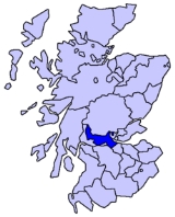
All Topics  
Stirlingshire


   Email Print
   Bookmark   Link


Stirlingshire


Stirlingshire or the County of Stirling (Siorrachd Sruighlea in Gaelic) is a registration county
Registration county

A registration county was, in England, Wales and Northern Ireland, a statistical unit used for the output of census information. Registration counties were formed by grouping together the registration districts wholly or partly within a county....
 of Scotland
Scotland

conventional_long_name = ScotlandAlba|common_name= Scotland|image_flag = Flag of Scotland.svg|flag_width = 130px...
, based around Stirling
Stirling

Stirling is a City status in the United Kingdom and former ancient burgh in Scotland, and is at the heart of the wider Stirling .The city is clustered around a large Stirling Castle and medi?val old-town....
, the former county town
County town

A county town is the 'capital' of a county in the United Kingdom or the Republic of Ireland. County towns are usually the location of administrative or judicial functions, or established over time as the de facto main town of a county....
. It borders Perthshire
Perthshire

Perthshire , officially the County of Perth, is a registration county in central Scotland. It extends from Strathmore, Angus and Perth & Kinross in the east, to the Pass of Drumochter in the north, Rannoch Moor and Ben Lui in the west, and Aberfoyle, Scotland in the south....
 to the north, Clackmannanshire
Clackmannanshire

Clackmannanshire and sometimes called Clacks is one of the 32 Local government in Scotland Council areas of Scotland of Scotland, and a Lieutenancy areas of Scotland, bordering Perth and Kinross, Stirling and Fife....
 and West Lothian
West Lothian

West Lothian is one of the 32 Unitary authority council areas in Scotland, and a Lieutenancy areas of Scotland. It borders the City of Edinburgh, Scottish Borders, South Lanarkshire, North Lanarkshire and Falkirk ....
 to the east, Lanarkshire
Lanarkshire

Lanarkshire , officially the County of Lanark, was formerly a Counties of Scotland of Scotland.It was bounded to the north by Stirlingshire and a detached portion of Dunbartonshire, to the northeast by Stirlingshire, West Lothian, to the east by Peeblesshire, to the southeast and south by Dumfriesshire, to the southwest by Dumfriesshi...
 to the south, and Dunbartonshire
Dunbartonshire

Dunbartonshire or the County of Dumbarton, is a Lieutenancy areas of Scotland and a registration county of Scotland. Until 1975 it was a Counties of Scotland....
 to the south-west.

Until 1975 it was a county
Counties of Scotland

The counties of Scotland were the principal subdivisions of Scotland of Scotland until 1975. Scotland's current Lieutenancy areas of Scotland and registration counties are largely based on them....
. Until the 1890s the county had two small exclaves: part of the parish of Logie
Logie

If you searched for Logie you may be looking for:*Logie, Dundee, a residential area in the City of Dundee, Scotland*Logie Coldstone, an Aberdeenshire village north of the River Dee in Scotland...
, which was surrounded by Perthshire
Perthshire

Perthshire , officially the County of Perth, is a registration county in central Scotland. It extends from Strathmore, Angus and Perth & Kinross in the east, to the Pass of Drumochter in the north, Rannoch Moor and Ben Lui in the west, and Aberfoyle, Scotland in the south....
, and the parish of Alva
Alva

Alva can refer to:Places*Alva, Clackmannanshire, a burgh in Scotland*Alva, Florida, a town in the United States*Alva, Oklahoma, a city in the United States...
, locally in Clackmannanshire
Clackmannanshire

Clackmannanshire and sometimes called Clacks is one of the 32 Local government in Scotland Council areas of Scotland of Scotland, and a Lieutenancy areas of Scotland, bordering Perth and Kinross, Stirling and Fife....
.


Discussion
Ask a question about 'Stirlingshire'
Start a new discussion about 'Stirlingshire'
Answer questions from other users
Full Discussion Forum


Recent Posts


Encyclopedia


Stirlingshire or the County of Stirling (Siorrachd Sruighlea in Gaelic) is a registration county
Registration county

A registration county was, in England, Wales and Northern Ireland, a statistical unit used for the output of census information. Registration counties were formed by grouping together the registration districts wholly or partly within a county....
 of Scotland
Scotland

conventional_long_name = ScotlandAlba|common_name= Scotland|image_flag = Flag of Scotland.svg|flag_width = 130px...
, based around Stirling
Stirling

Stirling is a City status in the United Kingdom and former ancient burgh in Scotland, and is at the heart of the wider Stirling .The city is clustered around a large Stirling Castle and medi?val old-town....
, the former county town
County town

A county town is the 'capital' of a county in the United Kingdom or the Republic of Ireland. County towns are usually the location of administrative or judicial functions, or established over time as the de facto main town of a county....
. It borders Perthshire
Perthshire

Perthshire , officially the County of Perth, is a registration county in central Scotland. It extends from Strathmore, Angus and Perth & Kinross in the east, to the Pass of Drumochter in the north, Rannoch Moor and Ben Lui in the west, and Aberfoyle, Scotland in the south....
 to the north, Clackmannanshire
Clackmannanshire

Clackmannanshire and sometimes called Clacks is one of the 32 Local government in Scotland Council areas of Scotland of Scotland, and a Lieutenancy areas of Scotland, bordering Perth and Kinross, Stirling and Fife....
 and West Lothian
West Lothian

West Lothian is one of the 32 Unitary authority council areas in Scotland, and a Lieutenancy areas of Scotland. It borders the City of Edinburgh, Scottish Borders, South Lanarkshire, North Lanarkshire and Falkirk ....
 to the east, Lanarkshire
Lanarkshire

Lanarkshire , officially the County of Lanark, was formerly a Counties of Scotland of Scotland.It was bounded to the north by Stirlingshire and a detached portion of Dunbartonshire, to the northeast by Stirlingshire, West Lothian, to the east by Peeblesshire, to the southeast and south by Dumfriesshire, to the southwest by Dumfriesshi...
 to the south, and Dunbartonshire
Dunbartonshire

Dunbartonshire or the County of Dumbarton, is a Lieutenancy areas of Scotland and a registration county of Scotland. Until 1975 it was a Counties of Scotland....
 to the south-west.

Until 1975 it was a county
Counties of Scotland

The counties of Scotland were the principal subdivisions of Scotland of Scotland until 1975. Scotland's current Lieutenancy areas of Scotland and registration counties are largely based on them....
. Until the 1890s the county had two small exclaves: part of the parish of Logie
Logie

If you searched for Logie you may be looking for:*Logie, Dundee, a residential area in the City of Dundee, Scotland*Logie Coldstone, an Aberdeenshire village north of the River Dee in Scotland...
, which was surrounded by Perthshire
Perthshire

Perthshire , officially the County of Perth, is a registration county in central Scotland. It extends from Strathmore, Angus and Perth & Kinross in the east, to the Pass of Drumochter in the north, Rannoch Moor and Ben Lui in the west, and Aberfoyle, Scotland in the south....
, and the parish of Alva
Alva

Alva can refer to:Places*Alva, Clackmannanshire, a burgh in Scotland*Alva, Florida, a town in the United States*Alva, Oklahoma, a city in the United States...
, locally in Clackmannanshire
Clackmannanshire

Clackmannanshire and sometimes called Clacks is one of the 32 Local government in Scotland Council areas of Scotland of Scotland, and a Lieutenancy areas of Scotland, bordering Perth and Kinross, Stirling and Fife....
. The Perthshire part of Logie was added to Stirlingshire, while Alva was annexed by Clackmannanshire.

In 1975 most of Stirlingshire was included in the Central Region, with Kilsyth and surrounding area becoming part of Strathclyde Region. Since 1996 the area of the former county has been part of the council area
Subdivisions of Scotland

For Local government in Scotland purposes, Scotland is divided into 32 areas designated as "council areas" which are all governed by unitary authority designated as "councils"....
s of East Dunbartonshire
East Dunbartonshire

East Dunbartonshire is one of the 32 council areas of Scotland. It borders onto the North-west of the City of Glasgow. It contains many of the suburbs of Glasgow as well as containing many of the city's commuter towns and villages....
, Falkirk
Falkirk (council area)

Falkirk is one of the 32 unitary authority council areas in Scotland. It borders onto North Lanarkshire to the south west, Stirling to the north west, West Lothian to the south east and, across the Firth of Forth to the north east, Fife....
, North Lanarkshire
North Lanarkshire

North Lanarkshire is one of 32 council areas in Scotland. It borders onto the north east of the City of Glasgow and contains much of Glasgow's suburbs and commuter towns and villages....
 and Stirling
Stirling (council area)

Stirling is one of the 32 unitary Local government in Scotland council areas of Scotland, and has a population of about 85,000. It was created under the Local Government etc Act 1994 with the boundaries of the Stirling district of the former Central Regions and districts of Scotland, and it covers most of the former county of Stirling and...
.

Coat of arms

The County Council of Stirling was granted a coat of arms
Coat of arms

A coat of arms, more properly called an armorial achievement, armorial bearings or often just arms for short, in European tradition, is a design belonging to a particular person and used by them in a wide variety of ways....
 by Lord Lyon King of Arms on September 29, 1890. The design of the arms commemorated the Scottish victory at the Battle of Bannockburn
Battle of Bannockburn

The Battle of Bannockburn was a significant Scotland victory in the Wars of Scottish Independence. It was the decisive battle in the First War of Scottish Independence....
 in the county. On the silver saltire
Saltire

A saltire, Saint Andrew's Cross, or crux decussata , is a Heraldry symbol in the form of a diagonal cross or letter X. Saint Andrew is said to have been martyred on such a cross....
 on blue of St Andrew was placed the rampant red lion from the royal arms of Scotland. Around this were placed two caltraps and two spur-rowels recalling the use of the weapons against the English cavalry.

On the abolition of the county council in 1975, the arms were regranted to Stirling District Council. They were regranted a second time in 1996 to the present Stirling Council, with the addition of supporters.

Subdivisions


Burghs

Until 1975 the county contained the following burghs:
  • The Royal Burgh
    Royal burgh

    A royal burgh was a type of Scottish burgh which had been founded by, or subsequently granted, a royal charter. Although abolished in 1975, the term is still used in many of the former burghs....
     of Stirling
    Stirling

    Stirling is a City status in the United Kingdom and former ancient burgh in Scotland, and is at the heart of the wider Stirling .The city is clustered around a large Stirling Castle and medi?val old-town....
     (from the 12th century) (No. 2 on map)
  • The Burgh of Bridge of Allan
    Bridge of Allan

    Bridge of Allan is a town in Stirling council area in Scotland, just north of the city of Stirling. It was formerly administered by Stirlingshire and Central Scotland....
     (a police burgh
    Police burgh

    A police burgh was a Scottish Burgh which had adopted a ?police system? for governing the town. They existed from 1833 to 1975....
     from 1870) (1)
  • The Burgh of Denny
    Denny, Falkirk

    Denny is a town in the Falkirk subdivisions of Scotland, Scotland and formerly in the county of Stirlingshire. It is situated seven miles west of Falkirk, and around 6 miles east of Cumbernauld....
     and Dunipace
    Dunipace

    Dunipace is a village in Stirlingshire, Scotland situated between Glasgow to the west and Edinburgh to the East.In 1876 Dunipace was joined with Denny, Falkirk to form the Denny and Dunipace Burgh....
     (a police burgh from 1877) (4)
  • The Burgh of Falkirk
    Falkirk

    Falkirk The town lies at the junction of the Forth and Clyde Canal and the Union Canal , a location which proved pivotal to the growth of Falkirk as a centre of heavy industry during the Industrial Revolution....
     (a burgh of barony
    Burgh of barony

    A burgh of barony is a type of Scottish town .They were distinct from royal burghs as the title was granted to a tenant-in-chief, a landowner who held his estates directly from the crown....
     from 1600, reformed 1832) (5)
  • The Burgh of Grangemouth
    Grangemouth

    Grangemouth is a town and former burgh in the subdivisions of Scotland of Falkirk , Scotland, and formerly in the County of Stirling. It is on the Firth of Forth, 3 miles east of Falkirk....
     (a police burgh from 1877) (6)
  • The Burgh of Kilsyth
    Kilsyth

    For other places named Kilsyth, see Kilsyth Kilsyth is a town of 10,100 roughly halfway between Glasgow and Stirling in North Lanarkshire, Scotland....
     (a burgh of barony from 1620, a police burgh from 1878) (3)


In 1930 Falkirk and Stirling became large burgh
Large burgh

In 1930, the Scotland burghs were split into two types, large burghs and small burghs. The Local Government of large burghs had more responsibilities and power than those of small burghs....
s, taking over some of the duties of the county council. The remaining four burghs became "small burghs", with limited powers.

Civil parishes

Following the boundary changes caused by the Local Government (Scotland) Act 1889
Local Government (Scotland) Act 1889

The Local Government Act 1889 is an Act of Parliament of the Parliament of the United Kingdom which was passed on 26 August 1889. The main effect of the act was to establish elected county councils in Scotland....
, the county contained the following civil parishes:
  • Airth
    Airth

    Airth is a village and former trading burgh in Falkirk, Scotland, eight miles north of Falkirk town, overlooked by Airth Castle. It retains two market crosses and a small number of historic houses....
     (No.1 on the map)
  • Baldernock
    Baldernock

    Baldernock is a small parish in East Dunbartonshire, Scotland, a 10 miles to the north of Glasgow city centre....
     (2)
  • Balfron
    Balfron

    Balfron, is a village in the Stirling council area of Scotland. It is situated near Endrick Water on the A875 road, 18 miles west of Stirling and 16 miles north of Glasgow....
     (3)
  • Bothkennar (4)
  • Buchanan
    Buchanan

    Buchanan may refer to:...
     (5)
  • Campsie
    Campsie, Stirlingshire

    Campsie is a hilly district in Stirlingshire, Scotland. It is noted for the beauty of Campsie Glen and the grandeur of the mountains known as the Campsie Fells....
     (6)
  • Denny
    Denny, Falkirk

    Denny is a town in the Falkirk subdivisions of Scotland, Scotland and formerly in the county of Stirlingshire. It is situated seven miles west of Falkirk, and around 6 miles east of Cumbernauld....
     (7)
  • Drymen
    Drymen

    Drymen is a village in Stirling district in central Scotland. Drymen lies to the west of the Campsie Fells and enjoys views to Dumgoyne on the east and to Loch Lomond on the west....
     (8)
  • Dunipace
    Dunipace

    Dunipace is a village in Stirlingshire, Scotland situated between Glasgow to the west and Edinburgh to the East.In 1876 Dunipace was joined with Denny, Falkirk to form the Denny and Dunipace Burgh....
     (9)
  • Falkirk
    Falkirk

    Falkirk The town lies at the junction of the Forth and Clyde Canal and the Union Canal , a location which proved pivotal to the growth of Falkirk as a centre of heavy industry during the Industrial Revolution....
     (10)
  • Fintry
    Fintry

    Fintry is a small village in central Scotland, nestled in the strath of the Endrick Water in the Campsie Fells some 35km north of Glasgow. It is within the Local government in Scotland council area of Stirling ....
     (11)
  • Gargunnock
    Gargunnock

    Gargunnock is a small village in the Stirling council area approximately seven miles west of Stirling, in Scotland. The 2001 census population was 944....
     (12)
  • Killearn
    Killearn

    Killearn is a small village of approximately 1700 people in the Stirling council area of Scotland. The village is located about north of Glasgow, and away from Loch Lomond....
     (13)
  • Kilsyth
    Kilsyth

    For other places named Kilsyth, see Kilsyth Kilsyth is a town of 10,100 roughly halfway between Glasgow and Stirling in North Lanarkshire, Scotland....
     (14)
  • Kippen
    Kippen

    Kippen is a small village approximately west of the city of Stirling, Scotland . It lies between the Gargunnock and Fintry hills and overlooks the strath of the River Forth....
     (15)
  • Larbert
    Larbert

    Larbert is a small town in the Falkirk of Scotland. The town lies in the Forth Valley above the River Carron which flows to the west. Larbert is located 3 miles from the shoreline of the Firth of Forth and 2.5 miles northwest of Falkirk, the main town in the area....
     (16)
  • Logie
    Logie

    If you searched for Logie you may be looking for:*Logie, Dundee, a residential area in the City of Dundee, Scotland*Logie Coldstone, an Aberdeenshire village north of the River Dee in Scotland...
     (23)
  • Muiravonside (17)
  • Polmont
    Polmont

    Polmont is a village in the Falkirk council area of Central Scotland. It lies towards the east of the town of Falkirk, north of the Union Canal , which runs adjacent to the village....
     (18)
  • St. Ninians
    St. Ninians

    St. Ninians is a long-standing settlement which is now a district of the city of Stirling in central Scotland. It is located approximately one mile south of the city centre....
     (19)
  • Slamannan
    Slamannan

    Slamannan is a village in the Falkirk Council area in Central Scotland. It stands on the cross of the B803 and B8022 roads, and near the banks of the River Avon, Falkirk....
     (20)
  • Strathblane
    Strathblane

    Strathblane is a village and List of civil parishes in Scotland at the extreme south of the Stirling , in central Scotland. It lies at the foothills of the Campsie Fells and the Kilpatrick Hills on the Blane Water, north of Glasgow, east-southeast of Dumbarton, and southwest of Stirling....
     (21)
  • Stirling
    Stirling

    Stirling is a City status in the United Kingdom and former ancient burgh in Scotland, and is at the heart of the wider Stirling .The city is clustered around a large Stirling Castle and medi?val old-town....
     (22)
In 1894 parish councils were established for the civil parishes, replacing the previous parochial boards. The parish councils were in turn replaced by district councils in 1930.

Districts

In 1930 the parishes ceased to be used for local government purposes, and the landward area of the county (the part outside the burghs) was divided into eight districts. These were abolished in 1975.
  • County of Stirling Central No.1
  • County of Stirling Central No.2 (Denny, Dunipace and Kilsyth areas)
  • County of Stirling Eastern No.1 (parishes of Airth and Larbert)
  • County of Stirling Eastern No.2 (Falkirk and Slamannan)
  • County of Stirling Eastern No.3 (parishes of Polmont and Muiravonside)
  • County of Stirling Western No.1
  • County of Stirling Western No.2
  • County of Stirling Western No.3 (Baldernock, Campsie, Strathblane)


Parliamentary constituencies

Following the Act of Union
Acts of Union 1707

The Acts of Union were a pair of Act of Parliament passed in 1707 by the Parliament of Scotland and the Parliament of England to put into effect the terms of the Treaty of Union that had been agreed on 22 July 1706, following negotiation between commissioners representing the parliaments of the two countries....
, Stirlingshire returned members to the House of Commons
British House of Commons

The House of Commons is the lower house of the Parliament of the United Kingdom, which also comprises the British monarchy and the House of Lords ....
 of the Parliament of the United Kingdom
Parliament of the United Kingdom

The Parliament of the United Kingdom of Great Britain and Northern Ireland is the supreme legislature in the United Kingdom and British overseas territories....
 from 1708.

1707 - 1918

  • The Royal Burgh of Stirling formed part of the Stirling burghs
    Stirling Burghs (UK Parliament constituency)

    Stirling Burghs was a district of burghs constituency of the British House of Commons of the Parliament of the United Kingdom from 1708 to 1918....
     constituency along with burghs in Fife and Perthshire.
  • The Burgh of Falkirk formed part of Falkirk Burghs
    Falkirk Burghs (UK Parliament constituency)

    Falkirk Burghs was a district of burghs constituency of the British House of Commons of the Parliament of the United Kingdom from 1832 to 1918....
    , along with burghs in Lanarkshire and Linlithgowshire.
  • The remainder of the county returned a single member as the parliamentary county of Stirlingshire
    Stirlingshire (UK Parliament constituency)

    Stirlingshire was a county constituency of the British House of Commons of the Parliament of Great Britain and later of the Parliament of the United Kingdom from 1708 until 1918....
    . The detached parish of Alva was annexed to the constituency of Clackmannanshire and Kinross
    Clackmannanshire and Kinross-shire (UK Parliament constituency)

    Clackmannanshire and Kinross-shire were constituency of the British House of Commons of the Parliament of Great Britain from 1708 to 1801 and of the Parliament of the United Kingdom from 1801 to 1918....
     by the Representation of the People (Scotland) Act 1832.


1918 - 1975

In 1918 seats in the House of Commons were redistributed. Stirlingshire was thereafter represented by three members of parliament.
  • The burghs of Stirling, Falkirk and Grangemouth formed the Stirling and Falkirk burghs
    Stirling and Falkirk (UK Parliament constituency)

    Stirling and Falkirk Burghs was a constituency represented in the British House of Commons of the Parliament of the United Kingdom from 1918, comprising the burghs of Stirling, Falkirk and Grangemouth....
     constituency. in 1974 the constituency was renamed Stirling, Falkirk and Grangemouth.
  • The eastern part of the county (defined in 1948 and 1970 as the Eastern No.1, Eastern No.2 and Eastern No.3 Districts) was combined with Clackmannanshire to form Clackmannan and East Stirlingshire
    Clackmannan and Eastern Stirlingshire (UK Parliament constituency)

    Clackmannan and Eastern Stirlingshire was a United Kingdom constituencies in the Clackmannan area of Central Scotland. It returned one Member of Parliament to the British House of Commons of the Parliament of the United Kingdom, MP elected by the first past the post system....
  • The remainder of the county was included in the constituency of West Stirlingshire
    Stirling and Clackmannan Western (UK Parliament constituency)

    Stirling and Clackmannan West was a county constituency of the British House of Commons of the Parliament of the United Kingdom from 1918 until 1945, when it was partly replaced by the new Stirlingshire West constituency....
     (named Stirling and Clackmannan West until 1945). The area included in the constituency was defined in 1948 and 1970 as the burghs of Bridge of Allan, Denny and Dunipace and Kilsyth; and the Central No. 1, Central No. 2, Western No. 1, Western No. 2 and Western No. 3 districts.


These boundaries continued in use until 1983, when new constituencies were formed based on the regions and districts created in 1975.

External links

  • at Electric Scotland