

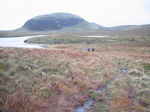
Kilpatrick Hills
Encyclopedia
Scotland
Scotland is a country that is part of the United Kingdom. Occupying the northern third of the island of Great Britain, it shares a border with England to the south and is bounded by the North Sea to the east, the Atlantic Ocean to the north and west, and the North Channel and Irish Sea to the...
, stretching from Dumbarton in the west to Strathblane
Strathblane
Strathblane is a village and parish in the registration county of Stirlingshire, situated in the southwestern part of the Stirling council area, in central Scotland. It lies at the foothills of the Campsie Fells and the Kilpatrick Hills on the Blane Water, north of Glasgow, east-southeast of...
in the east. Strathblane divides the Kilpatricks from the Campsie Fells
Campsie Fells
The Campsie Fells are a range of hills in central Scotland, stretching east to west, from Denny Muir to Dumgoyne, in Stirlingshire. . The highest point in the range is Earl's Seat which is 578 m high...
to the east, while to the north is part of the Loch Lomond and the Trossachs National Park
Loch Lomond and the Trossachs National Park
Loch Lomond and The Trossachs National Park is a national park in Scotland centred on Loch Lomond, and includes several ranges of hills, the Trossachs being the most famous...
. To west and south the hills are fringed by the settlements of Balloch
Balloch, West Dunbartonshire
Balloch is a small town in West Dunbartonshire, Scotland, at the foot of Loch Lomond. The name comes from the Gaelic for "the pass".Balloch is at the north end of the Vale of Leven, straddling the River Leven itself. It connects to the larger town of Alexandria and to the smaller village of...
, Dumbarton, Milton
Milton, West Dunbartonshire
Milton is a village in West Dunbartonshire, Scotland.It lies about 1 mile east of Dumbarton, on the A82 Glasgow-Loch Lomond road and below the Overtoun Bridge....
, Bowling, Old Kilpatrick
Old Kilpatrick
Old Kilpatrick is a village in West Dunbartonshire, Scotland.The village is on the north bank of the River Clyde immediately to the north of the Forth and Clyde Canal, three miles from Clydebank on the road to Dumbarton. The Great Western Road runs through Old Kilpatrick, and the next village to...
, Clydebank
Clydebank
Clydebank is a town in West Dunbartonshire, in the Central Lowlands of Scotland. Situated on the north bank of the River Clyde, Clydebank borders Dumbarton, the town with which it was combined to form West Dunbartonshire, as well as the town of Milngavie in East Dunbartonshire, and the Yoker and...
, Bearsden
Bearsden
Bearsden ) is a town in East Dunbartonshire, Scotland. It lies on the northwestern fringe of Greater Glasgow, approximately from the City Centre, and is effectively a suburb, with housing development coinciding with the introduction of a railway line in 1863, and from where the town gets its name...
and Milngavie
Milngavie
Milngavie , is a town in East Dunbartonshire, Scotland. It is on the Allander Water, at the northwestern edge of Greater Glasgow, and about from Glasgow city centre. It neighbours Bearsden....
. The majority of the range is within West Dunbartonshire
West Dunbartonshire
West Dunbartonshire is one of the 32 local government council areas of Scotland. Bordering onto the west of the City of Glasgow, containing many of Glasgow's commuter towns and villages as well as the city's suburbs, West Dunbartonshire also borders onto Argyll and Bute, Stirling, East...
, although it extends into the East Dunbartonshire
East Dunbartonshire
This article is about the East Dunbartonshire council area of Scotland. See also East Dunbartonshire .East Dunbartonshire is one of the 32 council areas of Scotland. It borders onto the north-west of the City of Glasgow. It contains many of the suburbs of Glasgow as well as containing many of...
and Stirling
Stirling (council area)
Stirling is one of the 32 unitary local government council areas of Scotland, and has a population of about 87,000 . It was created under the Local Government etc Act 1994 with the boundaries of the Stirling district of the former Central local government region, and it covers most of the former...
areas.
The highest points in the range are Duncolm (1314 feet (400.5 m)) and Fynloch (1313 feet (400.2 m)). The Kilpatricks offer a number of viewpoints: among the best known are Doughnot Hill and The Whangie. The hills are of volcanic origin, modified by subsequent glaciation.
Geology
The Kilpatrick Hills are a part the ClydeClyde
-Places named Clyde:In Scotland:* River Clyde* Firth of ClydeIn Australia:* Clyde, New South Wales* Clyde, Victoria* Clyde River, New South WalesIn Canada:* Clyde, Prince Edward Island* Clyde, Quebec* Clyde, Ontario* Clyde, Alberta...
Plateau Lavas. These are about 340 million years old. Basaltic types of rocks (lava
Lava
Lava refers both to molten rock expelled by a volcano during an eruption and the resulting rock after solidification and cooling. This molten rock is formed in the interior of some planets, including Earth, and some of their satellites. When first erupted from a volcanic vent, lava is a liquid at...
s, tuff
Tuff
Tuff is a type of rock consisting of consolidated volcanic ash ejected from vents during a volcanic eruption. Tuff is sometimes called tufa, particularly when used as construction material, although tufa also refers to a quite different rock. Rock that contains greater than 50% tuff is considered...
s and agglomerate
Agglomerate
Agglomerates are coarse accumulations of large blocks of volcanic material that contain at least 75% bombs...
s) predominate here. These are produced by denudation of the successive floes.
The Whangie in the north of the Kilpatricks is of particular interest to geologists and casual walkers alike. It consists of a slice of the hillside that has been separated from the main slope. This has created a narrow chasm of about 100 yards (91.4 m) in length through which visitors can walk. It is the result of glacial plucking
Plucking (glaciation)
Glacial plucking exploits pre-existing fractures in the bedrock. This plays a key role in opening and creating new fractures but has only provided small segments of loose material. This is then followed by the entrainment of the loosened rock by the ice. During the process of entrainment, loose...
. During the ice age, a glacier slowly dragged the frozen crag away from the hillside, causing this chasm to form.
The etymology of the Whangie's name is obscure but it might derive from the old Scots
Scots language
Scots is the Germanic language variety spoken in Lowland Scotland and parts of Ulster . It is sometimes called Lowland Scots to distinguish it from Scottish Gaelic, the Celtic language variety spoken in most of the western Highlands and in the Hebrides.Since there are no universally accepted...
for slice (as in whang o' cheese). Local folklore suggests that it was created by the devil flicking his tail as he flew past.
Topology and toponymy
The hills are named after the village of Old KilpatrickOld Kilpatrick
Old Kilpatrick is a village in West Dunbartonshire, Scotland.The village is on the north bank of the River Clyde immediately to the north of the Forth and Clyde Canal, three miles from Clydebank on the road to Dumbarton. The Great Western Road runs through Old Kilpatrick, and the next village to...
, which lies at their southern foot. The following table lists summits over 1000 feet (304.8 m). Duncolm, the highest point of the range, is also the only Marilyn
Marilyn (hill)
A Marilyn is a mountain or hill in the United Kingdom, Republic of Ireland or Isle of Man with a relative height of at least 150 metres , regardless of absolute height or other merit...
in the Kilpatricks, having a relative height
Topographic prominence
In topography, prominence, also known as autonomous height, relative height, shoulder drop , or prime factor , categorizes the height of the mountain's or hill's summit by the elevation between it and the lowest contour line encircling it and no higher summit...
of over 150 metres (492.1 ft).
| Name | Height | Coordinates | Notes |
|---|---|---|---|
| Duncolm | 1314 feet (400.5 m) | 55°57′55.69"N 4°27′4.97"W | Etymology: Scots Gaelic dun, hill-fort or hill of Colm, (Saint) Columba Columba Saint Columba —also known as Colum Cille , Colm Cille , Calum Cille and Kolban or Kolbjørn —was a Gaelic Irish missionary monk who propagated Christianity among the Picts during the Early Medieval Period... |
| Fynloch | 1313 feet (400.2 m) | 55°57′41.6"N 4°28′0.81"W | |
| Middle Duncolm | 1289 feet (392.9 m) | 55°57′46.7"N 4°27′26.98"W | |
| Darnycaip | 1232 feet (375.5 m) | 55°57′36.97"N 4°29′4.33"W | |
| Doughnot Hill | 1227 feet (374 m) | 55°58′0.55"N 4°29′21.67"W | |
| The Slacks | 1199 feet (365.5 m) | ||
| Auchineden | 1171 feet (356.9 m) | ||
| Craigarestie | 1166 feet (355.4 m) | ||
| Meikle White Hill | 1163 feet (354.5 m) | ||
| Berry Bank | 1152 feet (351.1 m) | ||
| Brown Hill | 1149 feet (350.2 m) | ||
| Cochno Hill | 1140 feet (347.5 m) | ||
| Knockupple | 1116 feet (340.2 m) | ||
| Craighirst | 1074 feet (327.4 m) | ||
| Thief's Hill | 1026 feet (312.7 m) |