

Stockton - Los Angeles Road
Encyclopedia
Stockton-Los Angeles Road, also known as the Millerton Road, Stockton-Mariposa Road, Stockton-Fort Miller Road or the Stockton-Visalia Road was established about 1853 following the discovery of gold on the Kern River
in Old Tulare County. The the route followed by the Stockton-Los Angeles Road (except that between Stockton and Davis's Ferry on the Tuolumne River
) is described in ITINERARY XXI. From Fort Yuma to Benicia, California, in The Prairie Traveler: A Hand-book for Overland Expeditions by Randolph Barnes Marcy. The Itinerary was derived from the Report of Lieutenant R. S. Williamson on his topographical survey party in 1853, that was in search of a railroad route through the interior of California.
prior to 1849 was carried north on the coast via El Camino Real
or later diverted to the north, from the San Fernando Mission inland via El Camino Viejo
"the old road", a route over the mountains north of Los Angeles
, along the west side of the San Joaquin Valley
then crossing to San Francisco Bay
at what is now Oakland
. During and after 1849, transportation and commerce to the gold mines of the Mother Lode
from the south became a northern extension of the Southern Immigrant Trail up the east side of the San Joaquin Valley from the El Camino Viejo.
The 49er
route from Los Angeles followed El Camino Viejo to San Fernando Mission then northward over the steep Fremont Pass, across the Santa Clarita Valley
and up through the San Francisquito Canyon
to San Francisquito Pass and north to La Laguna de Chico Lopez where the road divided. El Camino Viejo turned west northwest to Portezuela de Castac or Castac Pass (now Tejon Pass
) where a route diverted from "the old road" to a route down La Cañada de las Uvas or Grapevine Canyon into the then trackless and unsettled southern San Joaquin Valley
. The other route from the lake was directly north across the Antelope Valley
to cross over the Tehachapi Mountains
at the Old Tejon Pass, following Tejon Creek through Rancho Tejon into the San Joaquin Valley. Once in the San Joaquin Valley the route proceaded north crossing the various creeks and rivers near the eastern foothills of the Sierra's until they reached the gold fields.
In the next few years, settlements and miners camps gradually spread southward along this route along the Sierra foothills looking for new gold mines. Cattle and horses from Southern California, were driven north along the route and immigrants and teamsters contiuned to follow it. Ferries began to be established at the various crossing places.
In 1853, a Los Angeles businessman, Henry Clay Wiley installed a windlass
atop the Fremont Pass to speed and ease the accent and decent of the steep Santa Clara Divide, and built a tavern, hotel and stable nearby. In 1854, Wiley sold out to Sanford and Cyrus Lyon and it began to be called Lyon Station
. At the same time Phineas Banning
obtained the business of suppling Fort Tejon
. The Castac Pass now became known as the Fort Tejon Pass.
Lieutenant Robert Stockton Williamson of the Pacific Railroad surveyed the area in 1853. When his party crossed the Tehachapis by Tejon Pass he discribed it as "one of the worst roads he ever saw." He found a better road further west at La Cañada de las Uvas, far more practicable for wagons and the bulk of wagon traffic then went began to go that way. The old Tejon Pass route was abandoned in favor of the route through Grapevine Canyon and Fort Tejon Pass was shortended taking the name Tejon Pass..
in the huge but until then nearly unsettled Mariposa County. With unclaimed placer gold sites becoming more scarce in the Mother Lode region to the north, a stampede to the southern mines followed. Traffic to the south boomed. To make it practical to get the business of suppling the Kern River gold miners from San Pedro
, Phineas Banning
made a few adjustments to the old road, carving a small cut through the Santa Clara Divide then running eastward before descending down Elsmere Canyon to Lyon Station.
By 1855, Phineas Banning's wagon trains were carrying supplies from Los Angeles via Fort Tejon to Fort Miller (in what is now Fresno County) and for the Kern River gold rush. Several thousand miners participated in the Kern River Gold Rush but most were disappointed. Over the following seven or eight years other discoveries were made nearby at White River
, Keyesville, Owens River
, in the Slate Range and in the Coso District
that caused other mining booms. These kept the Stockton - Los Angeles Road active, connected with two trails cut across the Sierra Nevada mountains over which pack trains carrying supplies were sent to these new mines. A wagon road was also constructed from Visalia through Keyesville to Lone Pine
and Fort Independence
. By 1858 there were three stamp mill
s in the Kern river district, several other stamp mills were constructed a few years later to mill the ore of the Coso and Owens River
districts and the freighting of supplies to these places became a major business in Los Angeles and Stockton.
In 1858, the southern portion of the road from Los Angeles to Visalia was taken as part of the route of the Butterfield Overland Mail
, being used until 1861 when the American Civil War
put an end to its use. Commercial use by long haul freight wagons, stagecoaches, and livestock continued until the 1870s.
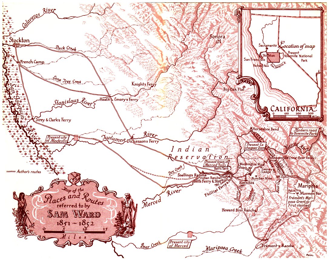
and the lower reaches of its tributaries. Due to competing ferry crossings and bridges, or the condition of the roads, different roads roughly paralleling the route would be taken. The route from Stockton crossed San Joaquin County to Dry Creek (now Lone Tree Creek)
about 2 miles north northeast of modern Escalon
then on to the crossings of the Stanislaus River
either at Heath & Emory's Ferry
up river from modern Oakdale
or at Taylor's Ferry Crossing
in Oakdale or further down river at Islips Ferry
.
The route then continued southeast to the Tuolumne River
crossings at either Dickinson's Ferry
, the principal ferry on the route, near modern Waterford, California
or at Davis's Ferry, two miles down the river from Dickinson's Ferry.
From Dickensons Ferry there is milage data from The Prairie Traveler Itinerary, the route reached the Merced River
, upriver from Snelling, California
after 18.87 miles. The three main crossings of the Merced River were located within 2 miles downstream from Merced Falls, a set of rapids on the Merced River 6 miles (9.7 km) east of Snelling. These ferries were Young's Ferry, Belt's Ferry, (later Murray's Ferry), and Phillips' Ferry. Phillips's Ferry was the place farthest east, upriver, where the Mariposa and Merced County boundary line crossed the Merced River; Murray's was only a short distance below Phillips's; but above Young's. Here the route had reached the edge of the eastern foothills and now it followed them southward, because such a route was nearer the mines and the river crossings were much easier than in the level plains below, that were more difficult to travel especially in wet weather and during the spring floods.
From Phillips Ferry the route ran 18.33 miles from the Merced River to Bear Creek
. Then after 10.39 miles it came to the crossing of the Mariposa River
, were John and "Paddy" Bennett, kept the Union post office. Another 10.39 miles and the road came to Newtons Crossing on the Chowchilla River
or "Big Mariposa" was reached. This section of road was the boundary line between Merced and Mariposa Counties from Phillips Ferry to Newton's Crossing when Merced County was created from Mariposa County in 1855.
From Newtons Crossing it was 12.15 miles to Fresno Crossing on the Fresno River
, about twelve miles east of what is now Madera, California
. From "Fresno Crossing” the route continued 7.72 miles to the crossing at Cottonwood Creek
and beyond in another 9.4 miles came to McCray's Ferry and Millerton
on the south bank of the San Joaquin River
with Fort Miller, midway on the route to Los Angeles.
From Fort Miller it was 25.73 miles to the Slough of King's River
and 12.3 miles more to Campbells Crossing on the Upper Kings River, 3 miles above modern Reedley, California
. William Campbell and John Poole operated Poole's Ferry at Campbells Crossing from 1851 to 1857. Smith's Ferry was established by James Smith and his wife, at what is now Reedley in 1855. Smith's was the only ferry boat on the Kings River that could be approached at high water and outlasted other Kings River ferries, being operated by the Smith family until 1874. Smith kept a two story, 11 room hotel nearby. In 1858, W. W. Hills established Hills Ferry upstream at Poole's Crossing on the King's River at what became Scotsburg
.
From Campbells Crossing it was 28.13 miles to the crossing at St. John's Creek, the first and northern most of the creeks of the "Four Creeks" which was crossed by the wagon-road. These streams were commonly known as the "Four Creeks" but were distributaries
of the Kaweah River
that divided itself after emerging from the Sierra's forming a delta before entering Tulare Lake
to the west. From St. John's Creek it was only 0.89 miles to the Kaweah River, the second and principal one of the "Four Creeks." Between these two streams the town of Visalia grew up from its beginning in 1853, located west downstream from the original route of the road. From the Kaweah River River it was 3.3 miles to Cameron Creek
, the third of the "Four Creeks." From Cameron Creek it was only 0.29 miles to Deep Creek
, forth and southern most of the "Four Creeks".
From Deep Creek the Stockton-Los Angeles road ran 22 miles to the Tule River
. From 1854 Peter Goodhue operated an emigrant trail stopping place on the bank of the Tule River until the river changed its course in 1862. It was also the site of the Tule River Stage Station for the Butterfield Overland Mail
, from 1858 to 1861. R. Porter Putnam, who ran the place in 1860 later founded Porterville
there in 1864.
From Tule River the Stockton-Los Angeles route ran 5.10 miles to More's Creek. 3.8 miles southeast of More's Creek was Fountain Springs
a settlement established before 1855, at the junction of the Stockton-Los Angeles Road and the road to the Kern River gold mines. 11.1 miles further on was Stickneys Ferry on White Creek
. From Stickneys Ferry it was 24.3 miles to the Depot Camp on Pose Creek. From the Depot Camp it was 10.8 miles to the Kern River
crossing at Gordons Ferry.
From Gordons Ferry it was 31 miles to the Depot Camp on Tejon Creek. From the Tejon Depot Camp it was 13.1 miles up the Grapevine Canyon, to Fort Tejon
and on to the summit of the Tejon Pass
. From the summit of Tejon Pass it was 24 miles to the summit of the road in the Coast Range in San Francisquito Pass
. From the pass it was 15.8 miles down San Francisquito Canyon
to the southeast fork of the Santa Clara River
and the Rancho San Francisco
. From there it was another 7.15 miles to the summit of the San Fernando Pass and Lyons Station
.
From the top of Freemont Pass it was 5.9 miles of a steep decent to the bottom of the pass, and on to Mission of San Fernando in the valley and another 10.7 miles to the Rancho Cahuenga
at the crossing of a branch of the Los Angeles River
. From the Cahuenga crossing it was another 10.2 miles to Los Angeles.
Kern River
The Kern River is a river in the U.S. state of California, approximately long. It drains an area of the southern Sierra Nevada mountains northeast of Bakersfield. Fed by snowmelt near Mount Whitney, the river passes through scenic canyons in the mountains and is a popular destination for...
in Old Tulare County. The the route followed by the Stockton-Los Angeles Road (except that between Stockton and Davis's Ferry on the Tuolumne River
Tuolumne River
The Tuolumne River is a California river that flows nearly from the central Sierra Nevada to the San Joaquin River in the Central Valley...
) is described in ITINERARY XXI. From Fort Yuma to Benicia, California, in The Prairie Traveler: A Hand-book for Overland Expeditions by Randolph Barnes Marcy. The Itinerary was derived from the Report of Lieutenant R. S. Williamson on his topographical survey party in 1853, that was in search of a railroad route through the interior of California.
Southern Route to the Goldfeilds
Transportation and commerce to the northern part of the state from Southern CaliforniaSouthern California
Southern California is a megaregion, or megapolitan area, in the southern area of the U.S. state of California. Large urban areas include Greater Los Angeles and Greater San Diego. The urban area stretches along the coast from Ventura through the Southland and Inland Empire to San Diego...
prior to 1849 was carried north on the coast via El Camino Real
El Camino Real (California)
El Camino Real and sometimes associated with Calle Real usually refers to the 600-mile California Mission Trail, connecting the former Alta California's 21 missions , 4 presidios, and several pueblos, stretching from Mission San Diego de Alcalá in San Diego...
or later diverted to the north, from the San Fernando Mission inland via El Camino Viejo
El Camino Viejo
El Camino Viejo à Los Angeles , also known as the Old Los Angeles Trail, established in 1820's, was the oldest north-south trail in the interior of Alta California...
"the old road", a route over the mountains north of Los Angeles
Los Ángeles
Los Ángeles is the capital of the province of Biobío, in the commune of the same name, in Region VIII , in the center-south of Chile. It is located between the Laja and Biobío rivers. The population is 123,445 inhabitants...
, along the west side of the San Joaquin Valley
San Joaquin Valley
The San Joaquin Valley is the area of the Central Valley of California that lies south of the Sacramento – San Joaquin River Delta in Stockton...
then crossing to San Francisco Bay
San Francisco Bay
San Francisco Bay is a shallow, productive estuary through which water draining from approximately forty percent of California, flowing in the Sacramento and San Joaquin rivers from the Sierra Nevada mountains, enters the Pacific Ocean...
at what is now Oakland
Oakland, California
Oakland is a major West Coast port city on San Francisco Bay in the U.S. state of California. It is the eighth-largest city in the state with a 2010 population of 390,724...
. During and after 1849, transportation and commerce to the gold mines of the Mother Lode
Mother Lode
Mother lode is a principal vein or zone of veins of gold or silver ore. The term probably came from a literal translation of the Spanish veta madre, a term common in old Mexican mining...
from the south became a northern extension of the Southern Immigrant Trail up the east side of the San Joaquin Valley from the El Camino Viejo.
The 49er
California Gold Rush
The California Gold Rush began on January 24, 1848, when gold was found by James W. Marshall at Sutter's Mill in Coloma, California. The first to hear confirmed information of the gold rush were the people in Oregon, the Sandwich Islands , and Latin America, who were the first to start flocking to...
route from Los Angeles followed El Camino Viejo to San Fernando Mission then northward over the steep Fremont Pass, across the Santa Clarita Valley
Santa Clarita Valley
The Santa Clarita Valley is the valley of the Santa Clara River in Southern California. It stretches through Los Angeles County and Ventura County. Its main population center is the city of Santa Clarita. The valley was part of the Rancho San Francisco Mexican land grant...
and up through the San Francisquito Canyon
San Francisquito Canyon
San Francisquito Canyon is a canyon created by the erosion of the Sierra Pelona Ridge of the San Gabriel Mountains within the Transverse Range of California, USA by San Francisquito Creek. At its head is the San Francisquito Pass which the early routes between Los Angeles and the San Joaquin...
to San Francisquito Pass and north to La Laguna de Chico Lopez where the road divided. El Camino Viejo turned west northwest to Portezuela de Castac or Castac Pass (now Tejon Pass
Tejon Pass
The Tejon Pass is a mountain pass at the southwest end of the Tehachapi Mountains linking Southern to Central California.-Geography:The apex of the pass is near the northwesternmost corner of Los Angeles County, north of Gorman...
) where a route diverted from "the old road" to a route down La Cañada de las Uvas or Grapevine Canyon into the then trackless and unsettled southern San Joaquin Valley
San Joaquin Valley
The San Joaquin Valley is the area of the Central Valley of California that lies south of the Sacramento – San Joaquin River Delta in Stockton...
. The other route from the lake was directly north across the Antelope Valley
Antelope Valley
The Antelope Valley in California, United States, is located in northern Los Angeles County and the southeastern portion of Kern County, California, and constitutes the western tip of the Mojave Desert...
to cross over the Tehachapi Mountains
Tehachapi Mountains
The Tehachapi Mountains , regionally also called The Tehachapis, are a mountain range in the Transverse Ranges system of California in the Western United States...
at the Old Tejon Pass, following Tejon Creek through Rancho Tejon into the San Joaquin Valley. Once in the San Joaquin Valley the route proceaded north crossing the various creeks and rivers near the eastern foothills of the Sierra's until they reached the gold fields.
In the next few years, settlements and miners camps gradually spread southward along this route along the Sierra foothills looking for new gold mines. Cattle and horses from Southern California, were driven north along the route and immigrants and teamsters contiuned to follow it. Ferries began to be established at the various crossing places.
In 1853, a Los Angeles businessman, Henry Clay Wiley installed a windlass
Windlass
The windlass is an apparatus for moving heavy weights. Typically, a windlass consists of a horizontal cylinder , which is rotated by the turn of a crank or belt...
atop the Fremont Pass to speed and ease the accent and decent of the steep Santa Clara Divide, and built a tavern, hotel and stable nearby. In 1854, Wiley sold out to Sanford and Cyrus Lyon and it began to be called Lyon Station
Lyons Station Stagecoach Stop
Lyons Station stagecoach stop, was located in what is now Newhall was the location of a tavern and stage depot called Wiley’s Station in the early 1850's located in the Newhall Pass on the Stockton - Los Angeles Road to the northern goldfeilds. It was a regular stop for early California stage...
. At the same time Phineas Banning
Phineas Banning
Phineas Banning was an American businessman, financier, and entrepreneur.Known as "The Father of the Port of Los Angeles," he was one of the founders of the town of Wilmington, which was named for his birthplace...
obtained the business of suppling Fort Tejon
Fort Tejon
Fort Tejon in California is a former United States Army outpost which was intermittently active from June 24, 1854, until September 11, 1864. It is located in the Grapevine Canyon area of Tejon Pass along Interstate 5, the main route through the mountains separating the Central Valley from Los...
. The Castac Pass now became known as the Fort Tejon Pass.
Lieutenant Robert Stockton Williamson of the Pacific Railroad surveyed the area in 1853. When his party crossed the Tehachapis by Tejon Pass he discribed it as "one of the worst roads he ever saw." He found a better road further west at La Cañada de las Uvas, far more practicable for wagons and the bulk of wagon traffic then went began to go that way. The old Tejon Pass route was abandoned in favor of the route through Grapevine Canyon and Fort Tejon Pass was shortended taking the name Tejon Pass..
Kern River Gold Rush
In 1853, D. B. James and Brigham James made the first discovery of gold at the Kern RiverKern River
The Kern River is a river in the U.S. state of California, approximately long. It drains an area of the southern Sierra Nevada mountains northeast of Bakersfield. Fed by snowmelt near Mount Whitney, the river passes through scenic canyons in the mountains and is a popular destination for...
in the huge but until then nearly unsettled Mariposa County. With unclaimed placer gold sites becoming more scarce in the Mother Lode region to the north, a stampede to the southern mines followed. Traffic to the south boomed. To make it practical to get the business of suppling the Kern River gold miners from San Pedro
San Pedro, Los Angeles, California
San Pedro is a port district of the city of Los Angeles, California, United States. It was annexed in 1909 and is a major seaport of the area...
, Phineas Banning
Phineas Banning
Phineas Banning was an American businessman, financier, and entrepreneur.Known as "The Father of the Port of Los Angeles," he was one of the founders of the town of Wilmington, which was named for his birthplace...
made a few adjustments to the old road, carving a small cut through the Santa Clara Divide then running eastward before descending down Elsmere Canyon to Lyon Station.
By 1855, Phineas Banning's wagon trains were carrying supplies from Los Angeles via Fort Tejon to Fort Miller (in what is now Fresno County) and for the Kern River gold rush. Several thousand miners participated in the Kern River Gold Rush but most were disappointed. Over the following seven or eight years other discoveries were made nearby at White River
White River (California)
The White River is a small river in the southern San Joaquin Valley of the U.S. state of California. The river is about long and flows entirely within Tulare County. It rises at roughly above sea level in the foothills of the Sierra Nevada on the northwest slope of Bull Run Peak...
, Keyesville, Owens River
Owens River
The Owens River is a river in southeastern California in the United States, approximately long. It drains into and through the Owens Valley, an arid basin between the eastern slope of the Sierra Nevada and the western faces of the Inyo and White Mountains. The river terminates at Owens Lake, but...
, in the Slate Range and in the Coso District
Coso (former settlement), California
Coso was a settlement in Inyo County, California. It is located in the Coso Range east-southeast of Coso Peak.Dr. Darwin French discovered gold at the site in 1860. The place was named Granite Springs in 1860. The name Coso comes from the Coso people, local Native Americans....
that caused other mining booms. These kept the Stockton - Los Angeles Road active, connected with two trails cut across the Sierra Nevada mountains over which pack trains carrying supplies were sent to these new mines. A wagon road was also constructed from Visalia through Keyesville to Lone Pine
Lone Pine
Lone Pine is a series of children's books written by Malcolm Saville.Although they were written over a 35-year timespan, between 1943 and 1978, the characters only age by a few years in the course of the series...
and Fort Independence
Fort Independence (California)
Fort Independence, originally Camp Independence, was established on Oak Creek, north of nearby modern Independence, California on July 4, 1862 during the Owens Valley Indian War. The fort was abandoned at the end of hostilities with the Owens Valley Paiute, in December 1864. However it was...
. By 1858 there were three stamp mill
Stamp mill
A stamp mill is a type of mill machine that crushes material by pounding rather than grinding, either for further processing or for extraction of metallic ores. Breaking material down is a type of unit operation....
s in the Kern river district, several other stamp mills were constructed a few years later to mill the ore of the Coso and Owens River
Owens River
The Owens River is a river in southeastern California in the United States, approximately long. It drains into and through the Owens Valley, an arid basin between the eastern slope of the Sierra Nevada and the western faces of the Inyo and White Mountains. The river terminates at Owens Lake, but...
districts and the freighting of supplies to these places became a major business in Los Angeles and Stockton.
In 1858, the southern portion of the road from Los Angeles to Visalia was taken as part of the route of the Butterfield Overland Mail
Butterfield Overland Mail
The Butterfield Overland Mail Trail was a stagecoach route in the United States, operating from 1857 to 1861. It was a conduit for the U.S. mail from two eastern termini, Memphis, Tennessee and St. Louis, Missouri, meeting Fort Smith, Arkansas, and continuing through Indian Territory, New Mexico,...
, being used until 1861 when the American Civil War
American Civil War
The American Civil War was a civil war fought in the United States of America. In response to the election of Abraham Lincoln as President of the United States, 11 southern slave states declared their secession from the United States and formed the Confederate States of America ; the other 25...
put an end to its use. Commercial use by long haul freight wagons, stagecoaches, and livestock continued until the 1870s.
The Route of the Stockton-Los Angeles Road
The route began at Stockton leaving the city toward the southeast toward the foothills of the Sierras to avoid the marshes called "tules" and the often flooded lowlands or lakes along the course of the San Joaquin RiverSan Joaquin River
The San Joaquin River is the largest river of Central California in the United States. At over long, the river starts in the high Sierra Nevada, and flows through a rich agricultural region known as the San Joaquin Valley before reaching Suisun Bay, San Francisco Bay, and the Pacific Ocean...
and the lower reaches of its tributaries. Due to competing ferry crossings and bridges, or the condition of the roads, different roads roughly paralleling the route would be taken. The route from Stockton crossed San Joaquin County to Dry Creek (now Lone Tree Creek)
Lone Tree Creek, San Joaquin County
Lone Tree Creek, formerly Dry Creek, a stream tributary to the San Joaquin River, in San Joaquin County and Stanislaus County, California. Named for the settlement of Lone Tree about 2 1/4 miles north northeast of modern Escalon. Its source is now, 3.4 miles north northwest of Oakdale, about...
about 2 miles north northeast of modern Escalon
Escalon, California
Escalon is a city in San Joaquin County, California, United States. The population was 7,132 at the 2010 census, up from 5,963 at the 2000 census.-Geography:...
then on to the crossings of the Stanislaus River
Stanislaus River
The Stanislaus River in California is one of the largest tributaries of the San Joaquin River. The river is long and has north, middle and south forks...
either at Heath & Emory's Ferry
East Oakdale, California
East Oakdale is a census-designated place in Stanislaus County, California, United States. It is part of the Modesto Metropolitan Statistical Area...
up river from modern Oakdale
Oakdale, California
Oakdale is a city in Stanislaus County, California, United States. It is part of the Modesto Metropolitan Statistical Area. The city was founded in 1871 when the Stockton & Visalia Railroad met the Copperopolis Railroad...
or at Taylor's Ferry Crossing
Oakdale, California
Oakdale is a city in Stanislaus County, California, United States. It is part of the Modesto Metropolitan Statistical Area. The city was founded in 1871 when the Stockton & Visalia Railroad met the Copperopolis Railroad...
in Oakdale or further down river at Islips Ferry
Langworth, California
Langworth is a small unincorporated town in Stanislaus County, California, United States and is 3 miles west of Oakdale, California.-History:Langworth is located on part of the 8 square league Rancho Thompson granted by Mexican Governor Pío Pico to Alpheus Basil Thompson in 1846...
.
The route then continued southeast to the Tuolumne River
Tuolumne River
The Tuolumne River is a California river that flows nearly from the central Sierra Nevada to the San Joaquin River in the Central Valley...
crossings at either Dickinson's Ferry
Roberts Ferry, California
Roberts Ferry is a small unincorporated town in Stanislaus County, California, United States, about 1 mile north of Turlock Reservoir.-External Links:* *...
, the principal ferry on the route, near modern Waterford, California
Waterford, California
Waterford, California is the eighth largest city in Stanislaus County, California, United States. The population was 8,456 at the 2010 census, up from 6,924 as of the 2000 census...
or at Davis's Ferry, two miles down the river from Dickinson's Ferry.
From Dickensons Ferry there is milage data from The Prairie Traveler Itinerary, the route reached the Merced River
Merced River
The Merced River , in the central part of the U.S. state of California, is a -long tributary of the San Joaquin River flowing from the Sierra Nevada into the Central Valley. It is most well known for its swift and steep course through the southern part of Yosemite National Park, and the...
, upriver from Snelling, California
Snelling, California
Snelling is a census-designated place in Merced County, California. It is located on the north bank of the Merced River north of Merced, at an elevation of 256 feet . The population was 231 at the 2010 census....
after 18.87 miles. The three main crossings of the Merced River were located within 2 miles downstream from Merced Falls, a set of rapids on the Merced River 6 miles (9.7 km) east of Snelling. These ferries were Young's Ferry, Belt's Ferry, (later Murray's Ferry), and Phillips' Ferry. Phillips's Ferry was the place farthest east, upriver, where the Mariposa and Merced County boundary line crossed the Merced River; Murray's was only a short distance below Phillips's; but above Young's. Here the route had reached the edge of the eastern foothills and now it followed them southward, because such a route was nearer the mines and the river crossings were much easier than in the level plains below, that were more difficult to travel especially in wet weather and during the spring floods.
From Phillips Ferry the route ran 18.33 miles from the Merced River to Bear Creek
Bear Creek
-Communities:* Bear Creek, Alabama, a town in Marion County* Bear Creek, Alaska, a census-designated place in Kenai Peninsula Borough* Bear Creek, Merced County, California, a census-designated place* Bear Creek Township, Michigan, a township in Emmet County...
. Then after 10.39 miles it came to the crossing of the Mariposa River
Mariposa Creek
Mariposa Creek, originally called the Mariposa River, is a creek that has its source in Mariposa near the town of Mariposa, California that flows through that town southwest through the Sierra foothills, into and across the San Joaquin Valley in Merced County, into the sloughs of the San Joaquin...
, were John and "Paddy" Bennett, kept the Union post office. Another 10.39 miles and the road came to Newtons Crossing on the Chowchilla River
Chowchilla River
The Chowchilla River is a river in central California and a minor tributary of the San Joaquin River. It flows for from the western side of the Sierra Nevada Range to the San Joaquin River system...
or "Big Mariposa" was reached. This section of road was the boundary line between Merced and Mariposa Counties from Phillips Ferry to Newton's Crossing when Merced County was created from Mariposa County in 1855.
From Newtons Crossing it was 12.15 miles to Fresno Crossing on the Fresno River
Fresno River
The Fresno River is a river in Central California and a major tributary of the San Joaquin River. It runs approximately from the Sierra Nevada Range to the San Joaquin River.-Course:...
, about twelve miles east of what is now Madera, California
Madera, California
Madera is a city in and the county seat of Madera County, California, United States. It is a principal city of the Madera–Chowchilla Metropolitan Statistical Area, which encompasses all of Madera County, and Metropolitan Fresno. It is located in California's San Joaquin Valley. As of the 2010...
. From "Fresno Crossing” the route continued 7.72 miles to the crossing at Cottonwood Creek
Cottonwood Creek
Cottonwood Creek may refer to:*Cottonwood Creek Ranch Airport*Cottonwood Creek , a Wild and Scenic River in the White Mountains...
and beyond in another 9.4 miles came to McCray's Ferry and Millerton
Millerton, Madera County, California
Millerton was the original county seat of Fresno County, formed in 1856. The county was much larger than it is today, comprising its current area plus all of what became Madera County and parts of what are now San Benito, Tulare, Kings, Inyo, and Mono counties.Millerton, then on the banks of the...
on the south bank of the San Joaquin River
San Joaquin River
The San Joaquin River is the largest river of Central California in the United States. At over long, the river starts in the high Sierra Nevada, and flows through a rich agricultural region known as the San Joaquin Valley before reaching Suisun Bay, San Francisco Bay, and the Pacific Ocean...
with Fort Miller, midway on the route to Los Angeles.
From Fort Miller it was 25.73 miles to the Slough of King's River
Kings River (California)
The Kings River is a major river of south-central California. About long, it drains an area of the high western Sierra Nevada and the Central Valley. A large alluvial fan has formed where the river's gradient decreases in the Central Valley so the river divides into distributaries...
and 12.3 miles more to Campbells Crossing on the Upper Kings River, 3 miles above modern Reedley, California
Reedley, California
Reedley is a city in Fresno County, California, United States. Reedley is located east-southeast of Fresno, at an elevation of 348 feet . The population at the 2010 census was 24,194. Its chief economic source is agriculture, particularly fruit and vegetable cultivation. The city is dubbed as...
. William Campbell and John Poole operated Poole's Ferry at Campbells Crossing from 1851 to 1857. Smith's Ferry was established by James Smith and his wife, at what is now Reedley in 1855. Smith's was the only ferry boat on the Kings River that could be approached at high water and outlasted other Kings River ferries, being operated by the Smith family until 1874. Smith kept a two story, 11 room hotel nearby. In 1858, W. W. Hills established Hills Ferry upstream at Poole's Crossing on the King's River at what became Scotsburg
Centerville, Fresno County, California
Centerville is a census-designated place in Fresno County, California. It is located on the Atchison, Topeka and Santa Fe Railroad east of Fresno, at an elevation of 394 feet...
.
From Campbells Crossing it was 28.13 miles to the crossing at St. John's Creek, the first and northern most of the creeks of the "Four Creeks" which was crossed by the wagon-road. These streams were commonly known as the "Four Creeks" but were distributaries
Distributary
A distributary, or a distributary channel, is a stream that branches off and flows away from a main stream channel. They are a common feature of river deltas. The phenomenon is known as river bifurcation. The opposite of a distributary is a tributary...
of the Kaweah River
Kaweah River
The Kaweah River in the U.S. state of California flows westward from the foothills of the Sierra Nevada into the Central Valley. It rises in forks in the southern Sierra Nevada inside Sequoia National Park, the longest of which is the Middle Fork, about long...
that divided itself after emerging from the Sierra's forming a delta before entering Tulare Lake
Tulare Lake
Tulare Lake, named Laguna de Tache by the Spanish, is a fresh-water dry lake with residual wetlands and marshes in southern San Joaquin Valley, California...
to the west. From St. John's Creek it was only 0.89 miles to the Kaweah River, the second and principal one of the "Four Creeks." Between these two streams the town of Visalia grew up from its beginning in 1853, located west downstream from the original route of the road. From the Kaweah River River it was 3.3 miles to Cameron Creek
Cameron Creek
Cameron Creek is one of the four main creeks that flow through the city of Visalia and the surrounding communities....
, the third of the "Four Creeks." From Cameron Creek it was only 0.29 miles to Deep Creek
Deep Creek
-Communities:*Deep Creek, California, former name of Cedarville, California*Deep Creek, Florida, an unincorporated community in Charlotte County*Deep Creek, Nevada*Deep Creek, Virginia, a former unincorporated town of the former Norfolk County...
, forth and southern most of the "Four Creeks".
From Deep Creek the Stockton-Los Angeles road ran 22 miles to the Tule River
Tule River
The Tule River, also called Rio de San Pedro or Rio San Pedro, is a river in Tulare County in the U.S. state of California. The river originates in the Sierra Nevada east of Porterville and consists of three forks, North, Middle and South. The North Fork and Middle Fork meet above Springville. The...
. From 1854 Peter Goodhue operated an emigrant trail stopping place on the bank of the Tule River until the river changed its course in 1862. It was also the site of the Tule River Stage Station for the Butterfield Overland Mail
Butterfield Overland Mail
The Butterfield Overland Mail Trail was a stagecoach route in the United States, operating from 1857 to 1861. It was a conduit for the U.S. mail from two eastern termini, Memphis, Tennessee and St. Louis, Missouri, meeting Fort Smith, Arkansas, and continuing through Indian Territory, New Mexico,...
, from 1858 to 1861. R. Porter Putnam, who ran the place in 1860 later founded Porterville
Porterville, California
Porterville is a city in the San Joaquin Valley, in Tulare County, California, United States. Porterville's population was 54,165 at the 2010 census. The city's population grew dramatically as the city annexed many properties and unincorporated areas in and around Porterville. Not included in the...
there in 1864.
From Tule River the Stockton-Los Angeles route ran 5.10 miles to More's Creek. 3.8 miles southeast of More's Creek was Fountain Springs
Fountain Springs, California
Fountain Springs was a settlement established in Tulare County before 1855, at the junction of the Stockton - Los Angeles Road and the road to the Kern River gold mines. From 1858 to 1861, Fountain Springs was a station on the Butterfield Overland Mail route, 14 miles southeast of Tule River...
a settlement established before 1855, at the junction of the Stockton-Los Angeles Road and the road to the Kern River gold mines. 11.1 miles further on was Stickneys Ferry on White Creek
White River (California)
The White River is a small river in the southern San Joaquin Valley of the U.S. state of California. The river is about long and flows entirely within Tulare County. It rises at roughly above sea level in the foothills of the Sierra Nevada on the northwest slope of Bull Run Peak...
. From Stickneys Ferry it was 24.3 miles to the Depot Camp on Pose Creek. From the Depot Camp it was 10.8 miles to the Kern River
Kern River
The Kern River is a river in the U.S. state of California, approximately long. It drains an area of the southern Sierra Nevada mountains northeast of Bakersfield. Fed by snowmelt near Mount Whitney, the river passes through scenic canyons in the mountains and is a popular destination for...
crossing at Gordons Ferry.
From Gordons Ferry it was 31 miles to the Depot Camp on Tejon Creek. From the Tejon Depot Camp it was 13.1 miles up the Grapevine Canyon, to Fort Tejon
Fort Tejon
Fort Tejon in California is a former United States Army outpost which was intermittently active from June 24, 1854, until September 11, 1864. It is located in the Grapevine Canyon area of Tejon Pass along Interstate 5, the main route through the mountains separating the Central Valley from Los...
and on to the summit of the Tejon Pass
Tejon Pass
The Tejon Pass is a mountain pass at the southwest end of the Tehachapi Mountains linking Southern to Central California.-Geography:The apex of the pass is near the northwesternmost corner of Los Angeles County, north of Gorman...
. From the summit of Tejon Pass it was 24 miles to the summit of the road in the Coast Range in San Francisquito Pass
San Francisquito Pass
San Francisquito Pass, is a mountain pass of the San Gabriel Mountains northeast of Green Valley, in Los Angeles County, California. This pass, at the elevation 3655 feet, was at the head of San Francisquito Canyon where from the time of the Spanish roads to the north from Los Angeles to the San...
. From the pass it was 15.8 miles down San Francisquito Canyon
San Francisquito Canyon
San Francisquito Canyon is a canyon created by the erosion of the Sierra Pelona Ridge of the San Gabriel Mountains within the Transverse Range of California, USA by San Francisquito Creek. At its head is the San Francisquito Pass which the early routes between Los Angeles and the San Joaquin...
to the southeast fork of the Santa Clara River
Santa Clara River (California)
The Santa Clara River is approximately long, located in southern California in the United States. It drains an area of the coastal mountains north of Los Angeles. The Santa Clara is one of the largest river systems along the coast of Southern California and one of only a few remaining river...
and the Rancho San Francisco
Rancho San Francisco
Rancho San Francisco was a land grant in present day northwestern Los Angeles County and eastern Ventura County, California. It was of by Governor Juan B. Alvarado to Antonio del Valle, a Spanish army officer, in recognition for his service to the state of Alta California...
. From there it was another 7.15 miles to the summit of the San Fernando Pass and Lyons Station
Lyons Station Stagecoach Stop
Lyons Station stagecoach stop, was located in what is now Newhall was the location of a tavern and stage depot called Wiley’s Station in the early 1850's located in the Newhall Pass on the Stockton - Los Angeles Road to the northern goldfeilds. It was a regular stop for early California stage...
.
From the top of Freemont Pass it was 5.9 miles of a steep decent to the bottom of the pass, and on to Mission of San Fernando in the valley and another 10.7 miles to the Rancho Cahuenga
Rancho Cahuenga
Rancho Cahuenga was a Mexican land grant in the San Fernando Valley, in present day Los Angeles County, California given in 1843 by governor Manuel Micheltorena to José Miguel Triunfo. Rancho Cahuenga is now a part of the city of Burbank, with the Los Angeles River channel running through it...
at the crossing of a branch of the Los Angeles River
Los Angeles River
The Los Angeles River is a river that starts in the San Fernando Valley, in the Simi Hills and Santa Susana Mountains, and flows through Los Angeles County, California, from Canoga Park in the western end of the San Fernando Valley, nearly southeast to its mouth in Long Beach...
. From the Cahuenga crossing it was another 10.2 miles to Los Angeles.
Decline of the Road
In the 1870s when construction of the railroad through the San Joaquin Valley and to Los Angeles, drew population from the Sierra foothills into the towns along the rail line and replaced long distance hauling of freight and passengers on the road. Diversion of water for irrigation dried up the lowlands of the San Joaquin Valley in the 1880s ending its role as the only passable road in bad weather, and the road fell into further disuse.External links
- Map of the southern mines: [California] by Charles Drayton Gibbes, 1852. The Bancroft Library, University of California, Berkeley, CA 94720-6000 Route of the early roads to the southern mines including what became the Stockton - Fort Miller Road, with milage.
- Official map of the State of California, 1854. Shows the early route of the Stockton - Los Angeles Road.
- Map of routes and crossings in the San Joaquin Valley including the Stockton-Mariposa Road, 1851-1852; from Events after the Mariposa Indian War, from Sam Ward in the Gold Rush (1861, 1949) by Samuel Ward