
Antelope Valley
Encyclopedia
California
California is a state located on the West Coast of the United States. It is by far the most populous U.S. state, and the third-largest by land area...
, United States
United States
The United States of America is a federal constitutional republic comprising fifty states and a federal district...
, is located in northern Los Angeles County
Los Angeles County, California
Los Angeles County is a county in the U.S. state of California. As of 2010 U.S. Census, the county had a population of 9,818,605, making it the most populous county in the United States. Los Angeles County alone is more populous than 42 individual U.S. states...
and the southeastern portion of Kern County, California
Kern County, California
Spreading across the southern end of the California Central Valley, Kern County is the fifth-largest county by population in California. Its economy is heavily linked to agriculture and to petroleum extraction, and there is a strong aviation and space presence. Politically, it has generally...
, and constitutes the western tip of the Mojave Desert
Mojave Desert
The Mojave Desert occupies a significant portion of southeastern California and smaller parts of central California, southern Nevada, southwestern Utah and northwestern Arizona, in the United States...
. It is situated between the Tehachapi
Tehachapi Mountains
The Tehachapi Mountains , regionally also called The Tehachapis, are a mountain range in the Transverse Ranges system of California in the Western United States...
and the San Gabriel Mountains
San Gabriel Mountains
The San Gabriel Mountains Range is located in northern Los Angeles County and western San Bernardino County, California, United States. The mountain range lies between the Los Angeles Basin and the Mojave Desert, with Interstate 5 to the west and Interstate 15 to the east...
.
The valley was named for the graceful pronghorn antelopes
Pronghorn
The pronghorn is a species of artiodactyl mammal endemic to interior western and central North America. Though not an antelope, it is often known colloquially in North America as the prong buck, pronghorn antelope, or simply antelope, as it closely resembles the true antelopes of the Old World and...
that are said to have roamed there until being eliminated by hunters and bad weather in the 1880s. The principal cities in the Antelope Valley are Palmdale
Palmdale, California
Palmdale is a city located in the center of northern Los Angeles County, California, United States.Palmdale was the first community within the Antelope Valley to incorporate as a city on August 24, 1962; 47 years later, voters approved creating a charter city in November, 2009. Palmdale is...
and Lancaster
Lancaster, California
Lancaster is a charter city in northern Los Angeles County, in the high desert, near the Kern County line. Lancaster currently ranks as the 30th largest city in California, and the 148th largest city in the United States. Lancaster is the principal city within the Antelope Valley...
.
Geography
Shaped like a sideways letter "V", the Antelope Valley comprises the western tip of the Mojave DesertMojave Desert
The Mojave Desert occupies a significant portion of southeastern California and smaller parts of central California, southern Nevada, southwestern Utah and northwestern Arizona, in the United States...
, opening up to the Victor Valley and the Great Basin
Great Basin
The Great Basin is the largest area of contiguous endorheic watersheds in North America and is noted for its arid conditions and Basin and Range topography that varies from the North American low point at Badwater Basin to the highest point of the contiguous United States, less than away at the...
to the east. Lying north of the San Gabriel Mountains
San Gabriel Mountains
The San Gabriel Mountains Range is located in northern Los Angeles County and western San Bernardino County, California, United States. The mountain range lies between the Los Angeles Basin and the Mojave Desert, with Interstate 5 to the west and Interstate 15 to the east...
and southeast of the Tehachapis
Tehachapi Mountains
The Tehachapi Mountains , regionally also called The Tehachapis, are a mountain range in the Transverse Ranges system of California in the Western United States...
, this desert
Desert
A desert is a landscape or region that receives an extremely low amount of precipitation, less than enough to support growth of most plants. Most deserts have an average annual precipitation of less than...
ecosystem
Ecosystem
An ecosystem is a biological environment consisting of all the organisms living in a particular area, as well as all the nonliving , physical components of the environment with which the organisms interact, such as air, soil, water and sunlight....
spans approximately 2200 mi2. Precipitation
Precipitation (meteorology)
In meteorology, precipitation In meteorology, precipitation In meteorology, precipitation (also known as one of the classes of hydrometeors, which are atmospheric water phenomena is any product of the condensation of atmospheric water vapor that falls under gravity. The main forms of precipitation...
in the surrounding mountain ranges contributes to groundwater recharge.
Flora and fauna
The Antelope Valley is home to a wide range of plants and animals. It is home to hundreds of plants like the Joshua tree, scrub oakCalifornia Scrub Oak
Quercus berberidifolia, the California Scrub Oak, is a small evergreen or semi-evergreen shrubby oak in the white oak section Quercus sect. Quercus...
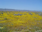
, Creosote, and the California poppy
California poppy
The California poppy is a perennial and annual plant, native to the United States, and the official state flower of California.- Description :...
. Winter brings much-needed rain which slowly penetrates the area's dry ground, bringing up native grasses and wildflowers. Poppy season depends completely on the precipitation, but a good bloom can be killed off by the unusual weather in the late winter and early spring months. Snow is not unusual for the Antelope Valley in spring, because it is often the most unstable weather the valley receives. The Antelope Valley gets its name from its history of pronghorn antelope
Pronghorn
The pronghorn is a species of artiodactyl mammal endemic to interior western and central North America. Though not an antelope, it is often known colloquially in North America as the prong buck, pronghorn antelope, or simply antelope, as it closely resembles the true antelopes of the Old World and...
grazing in large numbers. In 1882-85, the valley lost 30,000 head of antelope, almost half of the antelope for which it was named. Unusually heavy snows in both the mountains and the valley floor drove the antelope toward their normal feeding grounds in the eastern part of the valley. Since they would not cross the railroad tracks, many of them starved to death. Others were attacked by coyotes and wildcats or became easy prey for hunters. Once abundant, they mostly died off or migrated into the Central Valley. A drought in the early 1900s caused a scarcity in bunch grass, their main food source. Now the sighting of a pronghorn is rare, although there are still a small number in the valley. black bear
American black bear
The American black bear is a medium-sized bear native to North America. It is the continent's smallest and most common bear species. Black bears are omnivores, with their diets varying greatly depending on season and location. They typically live in largely forested areas, but do leave forests in...
s are resident, with sightings as recent as July 17, 2008; they like to hide in the hills behind the towns and often are only in the valley for foraging or resting in caves. When they come into towns, they are sometimes tranquilized and relocated (but often just outside of town). Bobcats and coyotes are very common. Coyotes often howl or cry at night or day during spring, summer, and fall months. tortoises
Desert Tortoise
The desert tortoise is a species of tortoise native to the Mojave desert and Sonoran desert of the southwestern United States and northwestern Mexico. They can be located in western Arizona, southeastern California, southern Nevada, and southwestern Utah. The species name agassizii is in honor of...
are not rare, but they often hide in burrows to escape the desert heat.
Water issues
Human water use in the Antelope Valley depends mainly on pumping of groundwater from the valley's aquiferAquifer
An aquifer is a wet underground layer of water-bearing permeable rock or unconsolidated materials from which groundwater can be usefully extracted using a water well. The study of water flow in aquifers and the characterization of aquifers is called hydrogeology...
s and on importing of additional water from the Los Angeles aqueduct
Aqueduct
An aqueduct is a water supply or navigable channel constructed to convey water. In modern engineering, the term is used for any system of pipes, ditches, canals, tunnels, and other structures used for this purpose....
. Long-term groundwater pumping has lowered the water table
Water table
The water table is the level at which the submarine pressure is far from atmospheric pressure. It may be conveniently visualized as the 'surface' of the subsurface materials that are saturated with groundwater in a given vicinity. However, saturated conditions may extend above the water table as...
, thereby increasing pumping lifts, reducing well efficiency, and causing land subsidence
Subsidence
Subsidence is the motion of a surface as it shifts downward relative to a datum such as sea-level. The opposite of subsidence is uplift, which results in an increase in elevation...
. While aqueducts supply additional water to meet increasing human demand for agricultural, industrial, and domestic uses, diversion of water from the Sacramento-San Joaquin River Delta in northern California has had, and continues to have, adverse environmental and social effects in the delta. "Over decades, [the] competing uses for water supply and habitat have jeopardized the Delta’s ability to meet either need. All stakeholders agree the estuary
Estuary
An estuary is a partly enclosed coastal body of water with one or more rivers or streams flowing into it, and with a free connection to the open sea....
is in trouble and requires long-term solutions to ensure reliable, quality water supplies and a healthy ecosystem".
Antelope Valley's rapid human population growth and development place considerable stress on the local and regional water systems. According to David Leighton of the United States Geological Survey (USGS), "A deliberate management effort will be required to meet future water demand in the Antelope Valley without incurring significant economic and environmental costs associated with overuse of the ground-water resource".
Human history
The first peoples of the Antelope Valley include the KawaiisuKawaiisu
thumb|Kawaiisu FamilyThe Kawaiisu are a Native American group who lived in the southern California Tehachapi Valley and across the Tehachapi Pass in the southern Sierra Nevada Mountains to the north, toward Lake Isabella and Walker Pass...
, Kitanemuk
Kitanemuk
The Kitanemuk were a Native American tribe and people who lived in the Tehachapi Mountains and the Antelope Valley area of the western Mojave Desert of southern California, United States.-Language:...
, Serrano
Serrano (people)
The Serrano are a Native American tribe of present day California, United States. They use the autonyms of Taaqtam, meaning "people"; Maarenga'yam, "people from Morongo"; and Yuhaviatam, "people of the pines." The Serrano historically populated the San Bernardino Mountains and extended east into...
, and Tataviam
Tataviam
The Tataviam , were called the Alliklik by their neighbors the Chumash , are a Native American group in southern California...
. The valley was first entered by Europeans in the 1770s during colonization of North America
North America
North America is a continent wholly within the Northern Hemisphere and almost wholly within the Western Hemisphere. It is also considered a northern subcontinent of the Americas...
. Father Francisco Garces
Francisco Garcés
Francisco Hermenegildo Tomás Garcés was a Spanish Franciscan missionary who explored much of the southwestern part of North America, including what are now Arizona, southern California, and northeastern Baja California. Garcés was born April 12, 1738, in Morata de Jalón , Zaragoza province,...
, a Spanish Franciscan
Franciscan
Most Franciscans are members of Roman Catholic religious orders founded by Saint Francis of Assisi. Besides Roman Catholic communities, there are also Old Catholic, Anglican, Lutheran, ecumenical and Non-denominational Franciscan communities....
friar, is believed to have traveled the west end of the valley in 1776. By 1808, the invaders forced native peoples out of the valley and into missions.
Jedediah Smith
Jedediah Strong Smith was a hunter, trapper, fur trader, trailblazer, author, cartographer, cattleman, and explorer of the Rocky Mountains, the American West Coast and the Southwest during the 19th century...
came through in 1827, and John C. Fremont
John C. Frémont
John Charles Frémont , was an American military officer, explorer, and the first candidate of the anti-slavery Republican Party for the office of President of the United States. During the 1840s, that era's penny press accorded Frémont the sobriquet The Pathfinder...
made a scientific observation of the valley in 1844 along with his other California explorations.
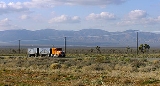
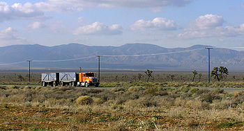
Stagecoach lines came through the valley along its foothills after Fremont's visit and were the preferred way of travel for colonists before the coming of the Southern Pacific
Southern Pacific Railroad
The Southern Pacific Transportation Company , earlier Southern Pacific Railroad and Southern Pacific Company, and usually simply called the Southern Pacific or Espee, was an American railroad....
Railroad in 1876. The rail service linking the valley to the Central Valley and Los Angeles started the first large influx of white settlers to the valley, and farms and towns soon sprouted on the valley floor.
The aircraft (now referred to as aerospace) industry took hold in the valley at Plant 42 in 1952. Edwards AFB, then called Muroc Army Air Field, was established in 1933.
Demographics
In recent decades the valley has become a bedroom community, to the Greater Los Angeles areaGreater Los Angeles Area
The Greater Los Angeles Area, or the Southland, is a term used for the Combined Statistical Area sprawled over five counties in the southern part of California, namely Los Angeles County, Orange County, San Bernardino County, Riverside County and Ventura County...
. Major housing tract development and population growth took off beginning in 1983, which has increased the population of Palmdale around 12 times its former size as of 2006. Neighboring Lancaster
Lancaster, California
Lancaster is a charter city in northern Los Angeles County, in the high desert, near the Kern County line. Lancaster currently ranks as the 30th largest city in California, and the 148th largest city in the United States. Lancaster is the principal city within the Antelope Valley...
has increased its population since the early 1980s to around 3 times its former level. Major retail has followed the population influx, centered on Palmdale's Antelope Valley Mall
Antelope Valley Mall
The Antelope Valley Mall is an enclosed shopping mall in Palmdale, California.Opened in September 1990, its buildings take up around 1 million square feet . Its physical main building, parking lots, and ring road businesses encompass an area a bit less than 0.5 by 0.5 miles .The main indoor...
. The Antelope Valley is home to over 475,000 people, and the population is expected to reach 1,000,000 by the year 2020.
Non-Hispanic whites
White American
White Americans are people of the United States who are considered or consider themselves White. The United States Census Bureau defines White people as those "having origins in any of the original peoples of Europe, the Middle East, or North Africa...
make up approximately 48% of the population of the Antelope Valley and form a majority or plurality in most of its cities and towns. Hispanics are the next largest group, followed by African Americans and Asian American
Asian American
Asian Americans are Americans of Asian descent. The U.S. Census Bureau definition of Asians as "Asian” refers to a person having origins in any of the original peoples of the Far East, Southeast Asia, or the Indian subcontinent, including, for example, Cambodia, China, India, Indonesia, Japan,...
s.
Some long-term residents living far out in the desert have been cited by Los Angeles County's Nuisance Abatement Teams for code violations, forcing them to make improvements or move. One of the properties is a church building which was used to film "Kill Bill". The code enforcers have arrived on some of their visits in SWAT team formats.
Military base
Edwards Air Force Base
Edwards Air Force Base is a United States Air Force base located on the border of Kern County, Los Angeles County, and San Bernardino County, California, in the Antelope Valley. It is southwest of the central business district of North Edwards, California and due east of Rosamond.It is named in...
lies east of Rosamond
Rosamond, California
Rosamond is a census-designated place in Kern County, California, USA, north of Palmdale, in the Antelope Valley, the westernmost desert valley of the Mojave Desert. Rosamond is also south of Mojave, , and north of Lancaster at an elevation of 2342 feet...
, 37 miles (60 km) northeast of Palmdale
Palmdale, California
Palmdale is a city located in the center of northern Los Angeles County, California, United States.Palmdale was the first community within the Antelope Valley to incorporate as a city on August 24, 1962; 47 years later, voters approved creating a charter city in November, 2009. Palmdale is...
. Edwards AFB's dry lakebeds are the lowest geographic elevation in the valley.
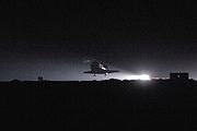
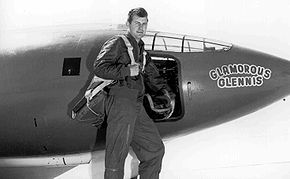
Significant amounts of U.S. military flight testing is performed there, and it has been the site of many important aeronautical accomplishments, including the first flight to break the sound barrier
Sound barrier
The sound barrier, in aerodynamics, is the point at which an aircraft moves from transonic to supersonic speed. The term, which occasionally has other meanings, came into use during World War II, when a number of aircraft started to encounter the effects of compressibility, a collection of several...
.
NASA
NASA
The National Aeronautics and Space Administration is the agency of the United States government that is responsible for the nation's civilian space program and for aeronautics and aerospace research...
space shuttle
Space Shuttle
The Space Shuttle was a manned orbital rocket and spacecraft system operated by NASA on 135 missions from 1981 to 2011. The system combined rocket launch, orbital spacecraft, and re-entry spaceplane with modular add-ons...
s originally landed at Edwards because the lake beds offer a vast landing area. NASA has since built a huge landing strip at Kennedy Space Center
Kennedy Space Center
The John F. Kennedy Space Center is the NASA installation that has been the launch site for every United States human space flight since 1968. Although such flights are currently on hiatus, KSC continues to manage and operate unmanned rocket launch facilities for America's civilian space program...
, and Edwards remains the backup in case of bad weather at Cape Canaveral
Cape Canaveral
Cape Canaveral, from the Spanish Cabo Cañaveral, is a headland in Brevard County, Florida, United States, near the center of the state's Atlantic coast. Known as Cape Kennedy from 1963 to 1973, it lies east of Merritt Island, separated from it by the Banana River.It is part of a region known as the...
.
NASA Hugh L. Dryden Flight Research Center is a tenant organization at Edwards AFB. The Center is best known for the X-15 experimental rocket ship program. It has been the home of NASA's high-performance aircraft research since it was founded for the X-1 program. The Orbiter is serviced there when it lands at Edwards.
Aerospace
Lockheed Martin
Lockheed Martin is an American global aerospace, defense, security, and advanced technology company with worldwide interests. It was formed by the merger of Lockheed Corporation with Martin Marietta in March 1995. It is headquartered in Bethesda, Maryland, in the Washington Metropolitan Area....
, Boeing
Boeing
The Boeing Company is an American multinational aerospace and defense corporation, founded in 1916 by William E. Boeing in Seattle, Washington. Boeing has expanded over the years, merging with McDonnell Douglas in 1997. Boeing Corporate headquarters has been in Chicago, Illinois since 2001...
, Northrop Grumman
Northrop Grumman
Northrop Grumman Corporation is an American global aerospace and defense technology company formed by the 1994 purchase of Grumman by Northrop. The company was the fourth-largest defense contractor in the world as of 2010, and the largest builder of naval vessels. Northrop Grumman employs over...
, and BAE Systems
BAE Systems
BAE Systems plc is a British multinational defence, security and aerospace company headquartered in London, United Kingdom, that has global interests, particularly in North America through its subsidiary BAE Systems Inc. BAE is among the world's largest military contractors; in 2009 it was the...
, among other aerospace-related companies. Notable projects assembled and/or designed there include the space shuttle orbiters, B-2 Spirit
B-2 Spirit
The Northrop Grumman B-2 Spirit is an American heavy bomber with low observable stealth technology designed to penetrate dense anti-aircraft defenses and deploy both conventional and nuclear weapons. The bomber has a crew of two and can drop up to eighty -class JDAM GPS-guided bombs, or sixteen ...
bomber, F-117 Nighthawk
F-117 Nighthawk
The Lockheed F-117 Nighthawk was a single-seat, twin-engine stealth ground-attack aircraft formerly operated by the United States Air Force . The F-117A's first flight was in 1981, and it achieved initial operating capability status in October 1983...
fighter, F-35 Joint Strike Fighter, and the Lockheed L-1011
Lockheed L-1011
The Lockheed L-1011 TriStar, commonly referred to as the L-1011 or TriStar, is a medium-to-long range, widebody passenger trijet airliner. It was the third widebody airliner to enter commercial operations, following the Boeing 747 and the McDonnell Douglas DC-10. Between 1968 and 1984, Lockheed...
Tristar, a passenger jet aircraft.
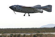
The newly dedicated Mojave Air & Space Port is also located in this region. The spaceport is famous as the base of operations for Scaled Composites
Scaled Composites
Scaled Composites is an aerospace company founded by Burt Rutan and currently owned by Northrop Grumman that is located at the Mojave Spaceport, Mojave, California, United States...
, the company that designed SpaceShipOne and won the X-Prize
Ansari X Prize
The Ansari X Prize was a space competition in which the X Prize Foundation offered a US$10,000,000 prize for the first non-government organization to launch a reusable manned spacecraft into space twice within two weeks...
.
Much of the work done at these facilities is performed in coordination with Edwards Air Force Base and the NASA Dryden Flight Research Center (see above), from the creation and testing of proof-of-concept X-planes, to Space Shuttle operations, to the manufacturing and integration and testing of new military aviation equipment.
Agriculture
Alfalfa
Alfalfa is a flowering plant in the pea family Fabaceae cultivated as an important forage crop in the US, Canada, Argentina, France, Australia, the Middle East, South Africa, and many other countries. It is known as lucerne in the UK, France, Australia, South Africa and New Zealand, and known as...
fields and fruit crops, farmers now are growing a wider variety of crops, such as carrots, onions, lettuce, and potatoes. As housing tracts continue to build in the middle of the valley, the farm operations are now found farther to the west and east sides than in previous decades.
Mining
The world's largest boraxBorax
Borax, also known as sodium borate, sodium tetraborate, or disodium tetraborate, is an important boron compound, a mineral, and a salt of boric acid. It is usually a white powder consisting of soft colorless crystals that dissolve easily in water.Borax has a wide variety of uses...
open-pit mine in the world is located near Boron
Boron, California
Boron is a census-designated place in Kern County, California, United States. Boron is located east-southeast of Castle Butte, at an elevation of 2467 feet . The population was 2,253 at the 2010 census, up from 2,025 at the 2000 census...
. Public touring is available.
Manufacturing
- U.S. Pole Company Inc.
- Senior Systems Technology
- Delta Scientific
- Lance Camper Manufacturing Corporation
- Harvest Farms Inc.
Colleges and universities
- The University of Antelope Valley is the first native University to the Antelope Valley. It consists of two campuses located in LancasterLancaster, CaliforniaLancaster is a charter city in northern Los Angeles County, in the high desert, near the Kern County line. Lancaster currently ranks as the 30th largest city in California, and the 148th largest city in the United States. Lancaster is the principal city within the Antelope Valley...
and a satellite classroom in RosamondRosamond, CaliforniaRosamond is a census-designated place in Kern County, California, USA, north of Palmdale, in the Antelope Valley, the westernmost desert valley of the Mojave Desert. Rosamond is also south of Mojave, , and north of Lancaster at an elevation of 2342 feet...
, CA. UAV offers a variety of certificate programs and several courses for Associate and Bachelor degrees, along with one Master's program in Criminal Justice. - The Antelope Valley Community College DistrictAntelope Valley Community College DistrictThe Antelope Valley Community College District is the local college district serving Palmdale and Lancaster in California's Antelope Valley. The college is accredited by the Western Association of Schools and Colleges.- About the AVCCD :...
is the local public college system that covers the area with a primary service area of 1945 square miles (5,037.5 km²) covering portions of Los Angeles and Kern counties. Instruction is offered at multiple sites, including Palmdale and LancasterLancaster, CaliforniaLancaster is a charter city in northern Los Angeles County, in the high desert, near the Kern County line. Lancaster currently ranks as the 30th largest city in California, and the 148th largest city in the United States. Lancaster is the principal city within the Antelope Valley...
, as well as through online and instructional television courses. It has 2 campuses. The main one, Antelope Valley CollegeAntelope Valley CollegeAntelope Valley College is a comprehensive community college located in Lancaster, California, USA. It is operated by the Antelope Valley Community College District, with a primary service area of covering portions of Los Angeles and Kern counties...
is a comprehensive community college located in Lancaster. The college offers Associate in Arts/Associate in Science (two-year) degrees in 67 fields, as well as certificate programs in 56 vocational areas. It also hosts a satellite location of California State University, BakersfieldCalifornia State University, BakersfieldCalifornia State University, Bakersfield is a public university located in Bakersfield, California, United States which was founded in 1965. CSUB opened in 1970 on a campus, becoming the 19th school in the California State University system...
-Antelope Valley, where students can obtain bachelor's and master's degrees. Enrollment for the 2007-2008 academic year exceeds 14,000. The second campus is a satellite campus in Palmdale with an enrollment of just over 500. - University of PhoenixUniversity of PhoenixThe University of Phoenix is a for-profit institution of higher learning. It is a wholly owned subsidiary of Apollo Group Inc. which is publicly traded , an S&P 500 corporation based in Phoenix, Arizona...
has a satellite campus in Lancaster. - University of La VerneUniversity of La VerneThe University of La Verne is a private research university located in La Verne, California . Founded in 1891, the university is composed of the College of Arts & Sciences, College of Business & Public Management, College of Education and Organizational Leadership, College of Law, and a Regional...
has a satellite campus in Palmdale. - DeVry UniversityDeVry UniversityDeVry University and DeVry Institute of Technology are divisions of DeVry Inc , a proprietary, for-profit higher education organization that is also the parent organization for Keller Graduate School of Management, Ross University, American University of the Caribbean, Apollo College, Western...
and its Keller Graduate School of Management has a satellite campus in Palmdale. - Chapman UniversityChapman UniversityChapman University is a private, non-profit university located in Orange, California affiliated with the Christian Church . Known for its blend of liberal arts and professional programs, Chapman University encompasses seven schools and colleges: Lawrence and Kristina Dodge College of Film and Media...
has a satellite campus in Palmdale. - The AERO Institute at the Palmdale Institute of Technology is a facility in Palmdale at the Civic Center. It is operated by the National Aeronautics and Space Administration (NASA), and the City of Palmdale, and distance learning through a number of universities is available including Purdue, USCUniversity of Southern CaliforniaThe University of Southern California is a private, not-for-profit, nonsectarian, research university located in Los Angeles, California, United States. USC was founded in 1880, making it California's oldest private research university...
, University of San DiegoUniversity of San DiegoThe University of San Diego is a Roman Catholic university in San Diego, California. USD offers more than sixty bachelor's, master’s, and doctoral programs...
, Pepperdine UniversityPepperdine UniversityPepperdine University is an independent, private, medium-sized university affiliated with the Churches of Christ. The university's campus overlooking the Pacific Ocean in unincorporated Los Angeles County, California, United States, near Malibu, is the location for Seaver College, the School of...
, Embry-Riddle Aeronautical UniversityEmbry-Riddle Aeronautical UniversityEmbry-Riddle Aeronautical University is a private university in the US specializing in aviation and aerospace engineering. It teaches the science, practice, and business of aviation and aerospace. Called "The Harvard of the Sky" by Time Magazine in 1979, Embry-Riddle has a history dating back to...
, CaltechCalifornia Institute of TechnologyThe California Institute of Technology is a private research university located in Pasadena, California, United States. Caltech has six academic divisions with strong emphases on science and engineering...
and Cal Poly Pomona. This specialized school offers graduate and undergraduate education in aerospace science, engineering, and technical skills. - West Coast Baptist CollegeWest Coast Baptist CollegeWest Coast Baptist College is an Independent Baptist Bible college in Lancaster, California, offering graduate and undergraduate degrees in Pastoral studies, evangelism, missions, church ministries, music, Christian education, youth ministry, and secretarial studies...
in Lancaster, is an unaccredited Independent Fundamental BaptistBaptistBaptists comprise a group of Christian denominations and churches that subscribe to a doctrine that baptism should be performed only for professing believers , and that it must be done by immersion...
BibleBibleThe Bible refers to any one of the collections of the primary religious texts of Judaism and Christianity. There is no common version of the Bible, as the individual books , their contents and their order vary among denominations...
college offering graduate and undergraduate degrees in Pastoral studies, evangelism, missions, church ministries, music, Christian education, youth ministry, and secretarial studies. West Coast opened in 1995, and now has about 1,000 students. - The Lancaster University Center in Lancaster provides local students education in engineering and technology. The $3.5 million reconstruction of Challenger Hall, located at the old Antelope Valley Fairgrounds, gave the new campus 13 classrooms, 2 of which are high tech distance learning rooms and 2 of which are lab classrooms, as well as office space. The school was created through partnerships with California State University, Bakersfield, California State University, FresnoCalifornia State University, FresnoCalifornia State University, Fresno, often referred to as Fresno State University and synonymously known in athletics as Fresno State , is one of the leading campuses of the California State University system, located at the northeast edge of Fresno, California, USA.The campus sits at the foot of...
, and local aerospace companies. - Career Care Institute, Inc. in Lancaster, is an accredited vocational school offering training in allied health field programs such as vocational nursing, medical assisting, medical billing, and limited permit x-ray technician. The school was founded in 1998, by Edmund Carrasco, who serves as the Chief Executive Officer. Career Care Institute has experienced steady growth by opening its second campus in the City of Ventura in 2004, and its third campus in the Moreno Valley Mall in 2007. The school maintains the best passage rates on the National Council Licensure Examination for Practical Nurses in the Antelope Valley.
High schools
- The Antelope Valley Union High School DistrictAntelope Valley Union High School DistrictThe Antelope Valley Union High School District is located in the Antelope Valley area of California, in northern Los Angeles County....
is the primary public school district covering the vast majority of high school education in the metropolitan Palmdale and Lancaster area. The district has 25,000 students in 8 regular high schools in Palmdale and Lancaster, a continuation school in each city, and a trade school in Palmdale. These are:- Antelope Valley High SchoolAntelope Valley High SchoolAntelope Valley High School is located in Lancaster, California, and is part of the Antelope Valley Union High School District, in northernmost Los Angeles County, California. It was founded in 1912. It is located near the western edge of the Mojave Desert...
- Lancaster - Antelope Valley Regional Occupational Program (AV ROP) - Palmdale
- Desert Winds High SchoolDesert Winds High SchoolDesert Winds High School is an intervention/retention high school in Casa Grande, Arizona. It is part of the Casa Grande Union High School District....
- Lancaster - Eastside High SchoolEastside High School (Lancaster, California)Eastside High School is located in Lancaster, California and is part of the Antelope Valley Union High School District. Eastside is the 8th and newest school in the district. The school opened its doors to freshmen in August 2005, with the first class graduating in May 2009. Until May 2009, the...
- Lancaster - Highland High SchoolHighland High School (Palmdale, California)Highland High School is located in Palmdale, California and is part of the Antelope Valley Union High School District. About 4,000 students attend Highland High School in grades 9 through 12. It received a California Distinguished School award in 2005....
- Palmdale - Lancaster High SchoolLancaster High School (Lancaster, California)Lancaster High School is a public, co-educational high school located in Lancaster, California. Founded in 1995, it is the sixth oldest comprehensive high school in the Antelope Valley Union High School District.-External links:*...
- Lancaster - Littlerock High SchoolLittlerock High SchoolLittlerock High School is a public, co-educational high school built in 1989, located in Littlerock, California. The school serves Littlerock and its surrounding communities such as Lake Los Angeles, Pearblossom, and Llano...
- Littlerock, California - Palmdale High SchoolPalmdale High SchoolPalmdale High School is located in Palmdale, California and is part of the Antelope Valley Union High School District. About 4,000 students attend Palmdale High School in grades 9 through 12. Palmdale High School was founded in 1956.-Automotive:...
- Palmdale - Pete Knight High SchoolPete Knight High SchoolKnight High School is located in Palmdale, California and is part of the Antelope Valley Union High School District. Knight High was the 7th general education school to join the district. The high school opened its doors to freshmen in August 2003 and these same freshmen were the first class to...
- Palmdale - Quartz Hill High SchoolQuartz Hill High SchoolQuartz Hill High School is a public, co-educational high school located in Quartz Hill, California. Founded in 1964, it is the third oldest comprehensive high school in the Antelope Valley Union High School District.-Campus:...
- Quartz Hill - R. Rex Parris Continuation High School - Palmdale
- Antelope Valley High School
- The Southern Kern Unified School DistrictSouthern Kern Unified School DistrictThe Southern Kern Unified School District is a school district in Kern County that serves the unincorporated Northern Antelope Valley communities of Rosamond and Willow Springs, California .The Southern Kern Unified School District has 9 schools:...
provides all public school education in RosamondRosamond, CaliforniaRosamond is a census-designated place in Kern County, California, USA, north of Palmdale, in the Antelope Valley, the westernmost desert valley of the Mojave Desert. Rosamond is also south of Mojave, , and north of Lancaster at an elevation of 2342 feet...
and nearby Willow SpringsWillow Springs, Kern County, CaliforniaWillow Springs is an unincorporated community in Kern County, California, United States. It is located west of Rosamond, at an elevation of 2523 feet .Willow Springs is the site of the Willow Springs International Motorsports Park....
. - The Muroc Joint Unified School DistrictMuroc Joint Unified School DistrictMuroc Joint Unified School District is a public K-12 unified school system of approximately 2400 students, located in the Mojave Desert approximately northeast of Los Angeles. It was founded as an elementary school in 1911 at Edwards. Boron students were bussed to the air base for their...
provides all public school education for Edwards Air Force BaseEdwards Air Force BaseEdwards Air Force Base is a United States Air Force base located on the border of Kern County, Los Angeles County, and San Bernardino County, California, in the Antelope Valley. It is southwest of the central business district of North Edwards, California and due east of Rosamond.It is named in...
, and the northern Antelope Valley communities of North EdwardsNorth Edwards, CaliforniaNorth Edwards is a census-designated place in Kern County, California, United States. North Edwards is located south-southeast of Castle Butte and north of Edwards Air Force Base, at an elevation of 2293 feet...
, and BoronBoron, CaliforniaBoron is a census-designated place in Kern County, California, United States. Boron is located east-southeast of Castle Butte, at an elevation of 2467 feet . The population was 2,253 at the 2010 census, up from 2,025 at the 2000 census...
. - The Mojave Unified School DistrictMojave Unified School DistrictThe Mojave Unified School District is a school district in Eastern Kern County that serves the town of Mojave and the city of California City, California .The Mojave Unified School District has 8 schools:* 3 high schools* 2 junior high schools...
provides all public school education in the northern Antelope Valley communities of MojaveMojave, CaliforniaMojave is a census-designated place in Kern County, California, United States. Mojave is located east of Bakersfield, at an elevation of 2762 feet...
and California CityCalifornia City, California-2000:According to the census of 2000, there were 8,385 people, 3,067 households, and 2,257 families residing in the city. As of 2006 the city's population grew 8.9% from 12,106 to 13,219. California City outpaced rivals Palmdale and Lancaster, making the city the 12th fastest growing city in...
.
There are also several private and home school high schools in the area, most notably:
- Abraham Lincoln High School - Rosamond
- Paraclete High SchoolParaclete High SchoolParaclete High School is a Roman Catholic high school in Lancaster, California, affiliated with the Roman Catholic Archdiocese of Los Angeles. It was established in 1963. 186 seniors graduated in the 2006-2007 school year...
- Bethel Christian High School
- Antelope Valley Christian School - Lancaster
- Desert Christian High School
- Pearblossom High School
- Desert Sands Charter Schools - Lancaster
- Desert Sands Charter Schools - Palmdale
- Opportunities for Learning Charter Schools - Lancaster
- Opportunities for Learning Charter Schools - Palmdale
School districts
- The Palmdale School DistrictPalmdale School DistrictThe Palmdale School District is a school district that serves a major part of the city of Palmdale, California .The Palmdale School District was first formed in 1888. Approximately 28,000 students are enrolled in the Palmdale School District...
is the area's largest school district, with an enrollment of over 28,000 in 29 schools. The district covers the central portion of the city. - The Lancaster School DistrictLancaster School District (California)The Lancaster School District is a school district that serves a major part of the city of Lancaster, California .The Lancaster School District was first formed in 1885. Approximately 15,500 students are enrolled in the Lancaster School District...
is the area's third largest school district after Palmdale and the A.V. High School District. This school district covers most of central and part of eastern Lancaster with 15,000 students in 19 schools. - The Westside Union School DistrictWestside Union School DistrictThe Westside Union School District in Southern California serves the western parts of Palmdale and Lancaster and their immediate suburbs, including Quartz Hill, Del Sur, Leona Valley, Antelope Acres, and Neenach.It enrolls kindergarten through eighth grade...
covers western Palmdale and Lancaster and their immediate suburbs including Quartz HillQuartz Hill, CaliforniaQuartz Hill is a census-designated place in Los Angeles County, California, United States. The population was 10,912 at the 2010 census, up from 9,890 at the 2000 census. The name is also shared with the neighboring district areas of its border cities, Palmdale, and Lancaster...
, Del SurDel Sur, CaliforniaDel Sur is an unincorporated community in the Mojave Desert, in Los Angeles County, California. The town has a population of about 1,750. The ZIP Code is 93536 and the community is inside area code 661.-Geography:...
, Leona ValleyLeona Valley, CaliforniaLeona Valley is a census-designated place located in the geographic Leona Valley of northern Los Angeles County, California, in the transition between the Sierra Pelona Mountains and Mojave Desert, just west of Palmdale and the Antelope Valley. The population was 1,607 at the 2010 census.Leona...
, and Antelope AcresAntelope Acres, CaliforniaAntelope Acres is an unincorporated community in Los Angeles County, California. It lies at an elevation of 2425 feet .Antelope Acres is located in the Antelope Valley the high desert area of northern Los Angeles County and is located approximately 13 miles from Downtown Lancaster, California and...
. It has over 8,250 students in 11 schools. - The Eastside Union School DistrictEastside Union School DistrictThe Eastside Union School District is a school district that serves the eastern part of the city of Lancaster, California .The Eastside Union School District has approximately 3,500 students enrolled in three elementary schools and one junior high school....
covers eastern Lancaster with 3,500 students in 4 schools. - The Keppel Union School DistrictKeppel Union School DistrictThe Keppel Union School District is a school district that serves the far eastern parts of the city of Palmdale, California, USA, and its immediate suburbs including Littlerock, Pearblossom, Sun Village, Llano, and Lake Los Angeles....
covers eastern Palmdale and its immediate suburbs, including the eastern Antelope Valley communities of Lake Los AngelesLake Los Angeles, CaliforniaLake Los Angeles is a census-designated place in Los Angeles County, California, United States. The population was 12,328 at the 2010 census, up from 11,523 at the 2000 census...
, PearblossomPearblossom, CaliforniaPearblossom is an unincorporated town located in Los Angeles County, California. The town has a population of 2,435. The ZIP Code is 93553 and the community is inside area code 661.-Geography:...
, LittlerockLittlerock, CaliforniaLittlerock is a census-designated place in Los Angeles County, California, United States. The population was 1,377 at the 2010 census, down from 1,402 at the 2000 census...
, Sun VillageSun Village, CaliforniaSun Village is a census-designated place in Los Angeles County, California. At an elevation of , it is located in the eastern Antelope Valley, north of Littlerock. The center of Sun Village may be considered to be Palmdale Boulevard and 90th Street East. The 2010 United States census reported Sun...
, LlanoLlano, CaliforniaLlano is an unincorporated town located in Los Angeles County, California, near the San Bernardino Countyline. The town has a population of about 1200.- Geography :...
, and ValyermoValyermo, CaliforniaValyermo is an unincorporated town located in the Mojave Desert, in Los Angeles County, California. The town has a population of about 450.- Geography :Valyermo is located about southeast of Palmdale in the Antelope Valley portion of Southern California...
. It has 6 schools with over 3,000 students. - The Southern Kern Unified School DistrictSouthern Kern Unified School DistrictThe Southern Kern Unified School District is a school district in Kern County that serves the unincorporated Northern Antelope Valley communities of Rosamond and Willow Springs, California .The Southern Kern Unified School District has 9 schools:...
provides all public school education in RosamondRosamond, CaliforniaRosamond is a census-designated place in Kern County, California, USA, north of Palmdale, in the Antelope Valley, the westernmost desert valley of the Mojave Desert. Rosamond is also south of Mojave, , and north of Lancaster at an elevation of 2342 feet...
and nearby Willow SpringsWillow Springs, Kern County, CaliforniaWillow Springs is an unincorporated community in Kern County, California, United States. It is located west of Rosamond, at an elevation of 2523 feet .Willow Springs is the site of the Willow Springs International Motorsports Park....
. - The Muroc Joint Unified School DistrictMuroc Joint Unified School DistrictMuroc Joint Unified School District is a public K-12 unified school system of approximately 2400 students, located in the Mojave Desert approximately northeast of Los Angeles. It was founded as an elementary school in 1911 at Edwards. Boron students were bussed to the air base for their...
provides all public school education for Edwards Air Force BaseEdwards Air Force BaseEdwards Air Force Base is a United States Air Force base located on the border of Kern County, Los Angeles County, and San Bernardino County, California, in the Antelope Valley. It is southwest of the central business district of North Edwards, California and due east of Rosamond.It is named in...
, and the northern Antelope Valley communities of North EdwardsNorth Edwards, CaliforniaNorth Edwards is a census-designated place in Kern County, California, United States. North Edwards is located south-southeast of Castle Butte and north of Edwards Air Force Base, at an elevation of 2293 feet...
, and BoronBoron, CaliforniaBoron is a census-designated place in Kern County, California, United States. Boron is located east-southeast of Castle Butte, at an elevation of 2467 feet . The population was 2,253 at the 2010 census, up from 2,025 at the 2000 census...
. - The Mojave Unified School DistrictMojave Unified School DistrictThe Mojave Unified School District is a school district in Eastern Kern County that serves the town of Mojave and the city of California City, California .The Mojave Unified School District has 8 schools:* 3 high schools* 2 junior high schools...
provides all public school education in the northern Antelope Valley communities of MojaveMojave, CaliforniaMojave is a census-designated place in Kern County, California, United States. Mojave is located east of Bakersfield, at an elevation of 2762 feet...
and California CityCalifornia City, California-2000:According to the census of 2000, there were 8,385 people, 3,067 households, and 2,257 families residing in the city. As of 2006 the city's population grew 8.9% from 12,106 to 13,219. California City outpaced rivals Palmdale and Lancaster, making the city the 12th fastest growing city in...
.
Culture
The Antelope Valley Symphony Orchestra is a professional ensemble that performs four concerts each year at the Lancaster Performing Arts Center. It is an auxiliary of Antelope Valley College, and performs regularly with the Antelope Valley College Civic Orchestra.Parks
- Antelope Valley California Poppy ReserveAntelope Valley California Poppy ReserveAntelope Valley California Poppy Reserve is a state-protected reserve of California, USA, harboring the most consistent blooms of California poppies, the state flower. The reserve is located in the rural westside of Antelope Valley in northern Los Angeles County, west of Lancaster. The reserve...
, home to CaliforniaCaliforniaCalifornia is a state located on the West Coast of the United States. It is by far the most populous U.S. state, and the third-largest by land area...
's state flower - Arthur B. Ripley Desert Woodland State ParkArthur B. Ripley Desert Woodland State ParkArthur B. Ripley Desert Woodland State Park is a state park of California, USA, protecting a stand of Joshua trees and junipers in the Antelope Valley...
- Antelope Valley Indian Museum State Historic ParkAntelope Valley Indian Museum State Historic ParkThe Antelope Valley Indian Museum State Historic Park is a state historic park of California, USA, interpreting Native American cultures of the Great Basin and surrounding regions. The park and its grounds are situated on the Antelope Valley's rural east side in northern Los Angeles County,...
- Saddleback Butte State ParkSaddleback Butte State ParkSaddleback Butte State Park is a state park located in southern California's Antelope Valley, in the community of Lake Los Angeles. The prominent feature of this park is Saddleback Butte, a butte that measures high. The park covers about of land, and was created in 1960 to protect the area's...
- Devil's Punchbowl County ParkDevil's Punchbowl (California)Devil's Punchbowl, elevation 4,750 ft , is a tilted sandstone formation in Los Angeles County. It is a county park within the Angeles National Forest on the northern slopes of the San Gabriel Mountains, near Littlerock, California. Short trails within the park showcase the geologic features along...
Hospitals
- Antelope Valley Hospital
- Palmdale Regional Medical CenterPalmdale Regional Medical CenterPalmdale Regional Medical Center is a private hospital located in Palmdale, California.This hospital was the most expensive hospital project Universal Health Services has ever undertaken at US$200 million. Adjacent to the hospital itself are two medical office towers, called the Palmdale Medical...
The Antelope Valley was formerly served by a county hospital, High Desert Hospital, which was converted into an urgent care clinic in 2003 due to the county's budget problems. As a result, indigent patients with serious but non-life-threatening medical conditions must seek treatment at Olive View – UCLA Medical Center in Sylmar, which is over 50 miles away.
Transportation
Major highways and roads
Include:- Angeles Forest HighwayAngeles Forest HighwayThe Angeles Forest Highway traverses the Angeles National Forest and connects the Los Angeles basin to the Antelope Valley by going up and over the San Gabriel Mountains. The highway is variously known as County Road N-3 or FH-59 or the Palmdale cutoff. It is about long...
, a key county road, connects Palmdale with Angeles Crest HighwayAngeles Crest HighwayThe Angeles Crest Highway is a two-lane segment of California State Route 2 in the United States. The road is in length, with its western terminus at the intersection at Foothill Boulevard in La Cañada Flintridge and its eastern terminus at State Route 138 northeast of Wrightwood...
as an alternate route to the Los Angeles basin. - The Antelope Valley Freeway (State Route 14California State Route 14State Route 14 is a north–south state highway in the U.S. state of California, largely in the Mojave Desert. The southern portion of the highway is signed as the Antelope Valley Freeway. The route connects Interstate 5, or Golden State Freeway, near Santa Clarita and with U.S. Route 395 near...
) - State Route 18 (connects SR 138 east of Palmdale to Victor ValleyVictor Valley, CaliforniaVictor Valley is a subregion of Southern California north of the San Bernardino Mountains in the Mojave Desert. It is located in San Bernardino County and situated east of the Antelope Valley and north of the Cucamonga Valley. The Victor Valley is part of the 14th largest metropolitan area, the...
and U.S.Route 395) There is currently a proposal to turn this into a freeway. - State Route 138California State Route 138State Route 138 is an east–west state highway generally following the northern foothills of the San Gabriel Mountains of southern California, USA from its junction with Interstate 5 south of Gorman eastward to Mount Anderson Junction, its eastern junction with State Route 18 south of...
(of which Pearblossom Highway comprises its eastern leg) - State Route 58California State Route 58State Route 58 is an east-west highway across the California Coast Ranges, the southern San Joaquin Valley, the Tehachapi Mountains, which border the southern Sierra Nevada, and the Mojave Desert. It runs between its western terminus near Santa Margarita and its eastern terminus at Barstow...
(freeway status now that the new Mojave bypass has been completed) - U.S. Route 395 (which technically lies east of the Valley proper)
On the ridgeline of the San Gabriel Mountains, the Angeles Crest Highway (State Route 2) snakes 60 miles (100 km) through the Angeles National Forest
Angeles National Forest
The Angeles National Forest of the U.S. National Forest Service is located in the San Gabriel Mountains of Los Angeles County, southern California. It was established on July 1, 1908, incorporating the first San Bernardino National Forest and parts of the former Santa Barbara and San Gabriel...
to La Canada Flintridge
La Cañada Flintridge, California
La Cañada Flintridge is a small and affluent city in Los Angeles County, California, United States whose population at the 2010 census was 20,246, down from 20,318 at the 2000 census. According to Forbes, as of 2010, La Cañada Flintridge ranks as the 143rd most expensive U.S...
and the Greater Los Angeles
Los Angeles, California
Los Angeles , with a population at the 2010 United States Census of 3,792,621, is the most populous city in California, USA and the second most populous in the United States, after New York City. It has an area of , and is located in Southern California...
metropolitan region.
Rail
- MetrolinkMetrolink (Southern California)Metrolink is a commuter rail system serving Los Angeles and the surrounding area of Southern California; it currently consists of six lines and 55 stations using of track....
passenger rail service to the Los Angeles Basin and other parts of Southern California provides service to Antelope Valley commuters at its Lancaster, Palmdale, and Vincent Grade/Acton stations. - AmtrakAmtrakThe National Railroad Passenger Corporation, doing business as Amtrak , is a government-owned corporation that was organized on May 1, 1971, to provide intercity passenger train service in the United States. "Amtrak" is a portmanteau of the words "America" and "track". It is headquartered at Union...
passenger rail service has a commuter bus that stops at the Palmdale Transportation CenterPalmdale Transportation CenterThe Palmdale Transportation Center is a multi-modal transportation center featuring a Metrolink rail station, a local bus hub, and commuter bus hub, in the city of Palmdale, California...
and the Lancaster Metrolink station, connecting Antelope Valley residents to the national rail network. - A future rail line is planned between the Palmdale Transportation Center and Palmdale Regional Airport. This will connect the airport directly with the extensive Southern CaliforniaSouthern CaliforniaSouthern California is a megaregion, or megapolitan area, in the southern area of the U.S. state of California. Large urban areas include Greater Los Angeles and Greater San Diego. The urban area stretches along the coast from Ventura through the Southland and Inland Empire to San Diego...
mass transit network. As of 2007 it is still unknown whether this will be a subway or an elevated rail line. - The California High Speed Rail authority has designated Palmdale as a stop on the future rail line between San FranciscoSan Francisco, CaliforniaSan Francisco , officially the City and County of San Francisco, is the financial, cultural, and transportation center of the San Francisco Bay Area, a region of 7.15 million people which includes San Jose and Oakland...
and San DiegoSan Diego, CaliforniaSan Diego is the eighth-largest city in the United States and second-largest city in California. The city is located on the coast of the Pacific Ocean in Southern California, immediately adjacent to the Mexican border. The birthplace of California, San Diego is known for its mild year-round...
. Due to a lack of funding, as of 2007 it will be several years before this project is begun.
Bus
- The Antelope Valley Transit AuthorityAntelope Valley Transit AuthorityAntelope Valley Transit Authority is the transit agency serving the cities of Palmdale, Lancaster and Northern Los Angeles County. Antelope Valley Transit Authority is operated under contract by Veolia Transportation, and is affiliated and offers connecting services with Metro and...
is the local city-bus system for metropolitan Palmdale and Lancaster. The service also operates a commuter bus network from its hubs at the Palmdale Transportation CenterPalmdale Transportation CenterThe Palmdale Transportation Center is a multi-modal transportation center featuring a Metrolink rail station, a local bus hub, and commuter bus hub, in the city of Palmdale, California...
and the Lancaster Park & Ride to several locations in Los AngelesLos Angeles, CaliforniaLos Angeles , with a population at the 2010 United States Census of 3,792,621, is the most populous city in California, USA and the second most populous in the United States, after New York City. It has an area of , and is located in Southern California...
. - Greyhound Bus has stops at the Palmdale Transportation Center and the Lancaster Metrolink station.
Airports
- Palmdale Regional AirportPalmdale Regional AirportPalmdale Airport is an airport in the city of Palmdale in Los Angeles County, California, United States.It contains two separate facilities:...
, co-sited with USAF Plant 42 is by far the largest and busiest airport in the valley and is owned by Los Angeles World AirportsLos Angeles World AirportsLos Angeles World Airports or LAWA is the airport oversight and operations department for the city of Los Angeles, California, United States...
(LAWA), the Los AngelesLos Angeles, CaliforniaLos Angeles , with a population at the 2010 United States Census of 3,792,621, is the most populous city in California, USA and the second most populous in the United States, after New York City. It has an area of , and is located in Southern California...
city government entity which owns and operates LAXLos Angeles International AirportLos Angeles International Airport is the primary airport serving the Greater Los Angeles Area, the second-most populated metropolitan area in the United States. It is most often referred to by its IATA airport code LAX, with the letters pronounced individually...
. Although mostly military flights occur at this airport, it also has an unused commercial terminal. - General William J. Fox AirfieldGeneral William J. Fox AirfieldGeneral William J. Fox Airfield , locally known as "Fox Field" is an airport located in Lancaster, California serving the Antelope Valley region of northern Los Angeles County. Although the airport is used primarily for general aviation, there are limited scheduled cargo operations, and the U.S...
in Lancaster is the valley's busiest general aviation airport. It is the fourth largest airport in the valley. Charter air service and helicopter rides are available. This airport also has the valley's only aviation school. - Inyokern AirportInyokern AirportInyokern Airport is a public airport located in Inyokern, California, United States, serving the Indian Wells Valley area of Kern County. It is owned by the Indian Wells Valley Airport District...
in Inyokern, near Ridgecrest, is a large general aviation airport with limited commercial airline service to Los Angeles International AirportLos Angeles International AirportLos Angeles International Airport is the primary airport serving the Greater Los Angeles Area, the second-most populated metropolitan area in the United States. It is most often referred to by its IATA airport code LAX, with the letters pronounced individually...
, serving the northern Antelope Valley and Indian Wells Valley communities. Charter service is also available. It is the area's third largest airport. - Mojave Air & Space Port in Mojave is a large civil aviation center and the second largest airport in the valley. VoyagerScaled Composites Voyager-See also:* The Virgin Atlantic GlobalFlyer was a jet-powered aircraft also designed by Burt Rutan and built by Scaled Composites, in which Steve Fossett made the first solo nonstop flight around the world in 2005....
and SpaceShipOne were developed and flown from its location. - Mountain Valley AirportMountain Valley AirportMountain Valley Airport is a privately-owned public-use airport located two nautical miles southeast of the central business district of Tehachapi, in Kern County, California, United States.The airport is used for glider operations and training...
in Tehachapi is a gliderport, privately owned but open to the public, which offers glider training for civilian and military pilots - Tehachapi Municipal AirportTehachapi Municipal AirportTehachapi Municipal Airport is a public airport located in Tehachapi, serving Kern County, California, USA. This general aviation airport covers and has one runway....
in Tehachapi is a small general aviation airport. - Agua Dulce AirparkAgua Dulce AirparkAgua Dulce Airpark , also known as Agua Dulce Airport, is a public-use airport located east of the central business district of Agua Dulce, in Los Angeles County, California, United States....
in Agua Dulce is a medium sized general aviation airport. - Rosamond Skypark AirportRosamond Skypark AirportRosamond Skypark Airport is a public-use airport in Rosamond, California.- Facilities and aircraft :Rosamond Skypark Airport covers an area of at an elevation of 2,415 feet above mean sea level...
in Rosamond is a small general aviation airport, privately owned and operated. - California City Municipal AirportCalifornia City Municipal AirportCalifornia City Municipal Airport is located two miles northwest of the central business district of California City, in the Fremont Valley of Kern County, California, USA...
in California City is a small general aviation airport. - Crystalaire Airport in Llano is a small airstrip principally dedicated to glider flights.
Notable people
- Erik AudéErik AudéErik Audé is an American actor/stuntman/professional poker player who was arrested and jailed in Pakistan for drug trafficking.-History:Audé was born in Beverly Hills, California....
, actor/stuntman turned professional poker player, went to Paraclete High SchoolParaclete High SchoolParaclete High School is a Roman Catholic high school in Lancaster, California, affiliated with the Roman Catholic Archdiocese of Los Angeles. It was established in 1963. 186 seniors graduated in the 2006-2007 school year...
before transferring over to Bethel Christian. - Judy GarlandJudy GarlandJudy Garland was an American actress and singer. Through a career that spanned 45 of her 47 years and for her renowned contralto voice, she attained international stardom as an actress in musical and dramatic roles, as a recording artist and on the concert stage...
, then known in the valley as Frances Gumm. As a girl, she would sing in public to her Lancaster neighbors. - John WayneJohn WayneMarion Mitchell Morrison , better known by his stage name John Wayne, was an American film actor, director and producer. He epitomized rugged masculinity and became an enduring American icon. He is famous for his distinctive calm voice, walk, and height...
, then known as Marion Morrison, was briefly a Lancaster schoolboy who was known not to tie up his horse properly when he left it by the street, as was the old time custom. - Daniel FryDaniel FryDaniel William Fry was an American contactee who claimed he had multiple contacts with an alien and took a ride in a remotely piloted alien spacecraft on July 4, 1949....
, a contactee, attended Antelope Valley High School in Lancaster during the 1920s. - The 90's R&B group All-4-OneAll-4-OneAll-4-One is a male R&B/pop group best known for their cover hit single "I Swear" from their self-titled 1994 debut album. The group comprises Jamie Jones, Delious Kennedy, Alfred Nevarez, and Tony Borowiak, all from the Antelope Valley and Mojave, California areas, but are based in the Los Angeles...
was from the AV. - Aldous HuxleyAldous HuxleyAldous Leonard Huxley was an English writer and one of the most prominent members of the famous Huxley family. Best known for his novels including Brave New World and a wide-ranging output of essays, Huxley also edited the magazine Oxford Poetry, and published short stories, poetry, travel...
drew writing inspiration from the solitude found at his LlanoLlano, CaliforniaLlano is an unincorporated town located in Los Angeles County, California, near the San Bernardino Countyline. The town has a population of about 1200.- Geography :...
home. A little known children's book, The Crows of Pearblossom, is set in the valley and was the only children's book he is known to have written. - Pancho BarnesPancho BarnesFlorence Lowe "Pancho" Barnes was a pioneer aviator, the founder of the first test pilots union and the owner of the Happy Bottom Riding Club, a bar and restaurant. She broke Amelia Earhart's air speed record in 1930...
the legendary aviatrix and friend to the U.S. Air Force's test pilots of what is now called Edwards Air Force Base, established the celebrated Happy Bottom Riding ClubHappy Bottom Riding ClubThe Happy Bottom Riding Club, more formally known as the Rancho Oro Verde Fly-Inn Dude Ranch, was a dude ranch restaurant and hotel operated by Pancho Barnes on the site of current-day Edwards Air Force Base in southern California's Antelope Valley, in the southwestern part of the United...
near Rogers Dry Lake in 1935, later living in CantilCantil, CaliforniaCantil is an unincorporated community in Kern County, California. It is located southwest of Saltdale, at an elevation of 2018 feet . Cantil is located in the northern Antelope Valley in the Fremont Valley section....
and BoronBoron, CaliforniaBoron is a census-designated place in Kern County, California, United States. Boron is located east-southeast of Castle Butte, at an elevation of 2467 feet . The population was 2,253 at the 2010 census, up from 2,025 at the 2000 census...
. - Chuck YeagerChuck YeagerCharles Elwood "Chuck" Yeager is a retired major general in the United States Air Force and noted test pilot. He was the first pilot to travel faster than sound...
was an early USAF test pilot at then-Muroc Army Air Field, now known as Edwards Air Force Base, where he became the first to break the sound barrier on October 14, 1947. - Frank ZappaFrank ZappaFrank Vincent Zappa was an American composer, singer-songwriter, electric guitarist, record producer and film director. In a career spanning more than 30 years, Zappa wrote rock, jazz, orchestral and musique concrète works. He also directed feature-length films and music videos, and designed...
attended Antelope Valley High SchoolAntelope Valley High SchoolAntelope Valley High School is located in Lancaster, California, and is part of the Antelope Valley Union High School District, in northernmost Los Angeles County, California. It was founded in 1912. It is located near the western edge of the Mojave Desert...
in Lancaster, graduating in 1958. He met Don Van Vliet (Captain Beefheart) there, a fellow student at the time. - Terence McKennaTerence McKennaTerence Kemp McKenna was an Irish-American philosopher, psychonaut, researcher, teacher, lecturer and writer on many subjects, such as human consciousness, language, psychedelic drugs, the evolution of civilizations, the origin and end of the universe, alchemy, and extraterrestrial beings.-Early...
noted writer, public speaker, philosopher, psychonaut, and ethnobotanist graduated from Antelope Valley High School in 1965. - Jeff Dandurand, more frequently known as Jeff DuranJeff DuranJeff Dandurand ,, mostly known as Jeff Duran, is an American radio personality, comedian, musician and former child actor who is based in Los Angeles, California.-Child actor:...
, lives in Palmdale due to his daily radio show. - Tippi HedrenTippi HedrenNathalie Kay "Tippi" Hedren is an American actress and former fashion model with a career spanning six decades. She is primarily known for her roles in two Alfred Hitchcock films, The Birds and Marnie, and her extensive efforts in animal rescue at Shambala Preserve, an wildlife habitat which she...
, who made her major motion picture debut in The BirdsThe Birds (film)The Birds is a 1963 horror film directed by Alfred Hitchcock based on the 1952 short story "The Birds" by Daphne du Maurier. It depicts Bodega Bay, California which is, suddenly and for unexplained reasons, the subject of a series of widespread and violent bird attacks over the course of a few...
, is an Acton resident since at least 1981 (Acton not being in the valley proper, but nearby to the south). - Michael Deaver, former aide to Ronald ReaganRonald ReaganRonald Wilson Reagan was the 40th President of the United States , the 33rd Governor of California and, prior to that, a radio, film and television actor....
, is a former Mojave resident. - Kathleen SoliahKathleen SoliahSara Jane Olson, formerly Kathleen Ann Soliah , was a member of the Symbionese Liberation Army in the 1970s. She grew up in Palmdale, California, the daughter of Palmdale High School teacher and coach Martin Soliah. She has lived much of her life under the alias Sara Jane Olson, which is now her...
, who achieved notoriety as a member of the Symbionese Liberation ArmySymbionese Liberation ArmyThe Symbionese Liberation Army was an American self-styled left-wing urban militant group active between 1973 and 1975 that considered itself a revolutionary vanguard army...
in the 1970s and then as a fugitive living a quiet, middle-class life in St. Paul, Minnesota, grew up in Desert View HighlandsDesert View Highlands, CaliforniaDesert View Highlands is a census-designated place in Los Angeles County, California, United States. The population was 2,360 at the 2010 census, up from 2,337 at the 2000 census...
, graduating from Palmdale High School in 1965. - Burt RutanBurt RutanElbert Leander "Burt" Rutan is an American aerospace engineer noted for his originality in designing light, strong, unusual-looking, energy-efficient aircraft...
and his brother Dick RutanDick RutanRichard Glenn "Dick" Rutan is an aviator who piloted the Voyager aircraft around the world non-stop with co-pilot Jeana Yeager...
of Scaled CompositesScaled CompositesScaled Composites is an aerospace company founded by Burt Rutan and currently owned by Northrop Grumman that is located at the Mojave Spaceport, Mojave, California, United States...
, the firm which produced SpaceShipOne and the Voyager aerospace vehicles, work out of Mojave Air & Space Port in Mojave. - R. Lee ErmeyR. Lee ErmeyRonald Lee Ermey is a retired United States Marine Corps drill instructor and actor.Ermey has often played the roles of authority figures, such as his breakout performance as Gunnery Sergeant Hartman in Full Metal Jacket, Mayor Tilman in the Alan Parker film Mississippi Burning, Bill Bowerman in...
of Full Metal JacketFull Metal JacketFull Metal Jacket is a 1987 war film produced and directed by Stanley Kubrick. It is an adaptation of the 1979 novel The Short-Timers by Gustav Hasford and stars Matthew Modine, Vincent D'Onofrio, R. Lee Ermey, Arliss Howard and Adam Baldwin. The film follows a platoon of U.S...
and Mail CallMail CallMail Call was a television program appearing on the History Channel and hosted by R. Lee Ermey, a retired United States Marine Corps Staff Sergeant, . The show debuted on August 4, 2002 as part of the 'Fighting Fridays' lineup...
fame is a current Palmdale resident. - Home to members of the punk bands Slick ShoesSlick ShoesSlick Shoes was a pop punk band with Christian origins from Antelope Valley, California. Their name comes from the hit 1985 movie, The Goonies, 'slick shoes' being one of the character Data's many gadgets. The band formed in 1994 and made their first release as a self-titled EP in 1997. They...
and KillradioKillradioKillradio was a punk rock band formed in 2001 in Northridge, California. They used a mix of music styles, including hardcore, post-punk, ska, funk, and hip-hop...
. - Joseph Foreman, more frequently known as AfromanAfromanJoseph Edgar Foreman , better known by his stage name Afroman, is an American rapper who came to prominence with his singles "Because I Got High" and "Crazy Rap". "Because I Got High" circulated around the Internet before becoming a hit worldwide...
, lives in Palmdale.
See also Aerospace Walk of Honor
Aerospace Walk of Honor
The Aerospace Walk of Honor in Lancaster, California, USA, honors test pilots who have contributed to aviation and space research and development....
- downtown Lancaster sidewalk tribute to the U. S. Air Force flight test community.
- Vilma Drever, who started the non-profit animal rescue called Antelope Valley Dog and Cat Rescue where Vilma ventures out into the desert to find, rescue and rehabilitate abandoned petsAbandoned petsAbandoned pets are pets that are, for instance, left behind when a home goes into foreclosure or their owner passes away. These animals can be left alone on the property or dropped off at a shelter. While some are left in a shelter, they are typically discovered after the foreclosure process when...
.
Cities over 100,000 population
- LancasterLancaster, CaliforniaLancaster is a charter city in northern Los Angeles County, in the high desert, near the Kern County line. Lancaster currently ranks as the 30th largest city in California, and the 148th largest city in the United States. Lancaster is the principal city within the Antelope Valley...
(population 156,633) - incorporated in 1977 - PalmdalePalmdale, CaliforniaPalmdale is a city located in the center of northern Los Angeles County, California, United States.Palmdale was the first community within the Antelope Valley to incorporate as a city on August 24, 1962; 47 years later, voters approved creating a charter city in November, 2009. Palmdale is...
(population 152,750) - incorporated in 1962
Cities less than 100,000 population
- California CityCalifornia City, California-2000:According to the census of 2000, there were 8,385 people, 3,067 households, and 2,257 families residing in the city. As of 2006 the city's population grew 8.9% from 12,106 to 13,219. California City outpaced rivals Palmdale and Lancaster, making the city the 12th fastest growing city in...
(population 14,828) - incorporated in 1965 - CentennialCentennial, CaliforniaCentennial, California, is a proposed planned community between Bakersfield and Los Angeles in Los Angeles County located north of Highway 138, and just east of Interstate 5; specifically, surrounding the north and east sides of Quail Lake...
(planned for 70,000).
Unincorporated towns and districts
Over 10,000 population- RosamondRosamond, CaliforniaRosamond is a census-designated place in Kern County, California, USA, north of Palmdale, in the Antelope Valley, the westernmost desert valley of the Mojave Desert. Rosamond is also south of Mojave, , and north of Lancaster at an elevation of 2342 feet...
(18,150) - Lake Los AngelesLake Los Angeles, CaliforniaLake Los Angeles is a census-designated place in Los Angeles County, California, United States. The population was 12,328 at the 2010 census, up from 11,523 at the 2000 census...
(12,328) - Quartz HillQuartz Hill, CaliforniaQuartz Hill is a census-designated place in Los Angeles County, California, United States. The population was 10,912 at the 2010 census, up from 9,890 at the 2000 census. The name is also shared with the neighboring district areas of its border cities, Palmdale, and Lancaster...
(10,912) - Sun VillageSun Village, CaliforniaSun Village is a census-designated place in Los Angeles County, California. At an elevation of , it is located in the eastern Antelope Valley, north of Littlerock. The center of Sun Village may be considered to be Palmdale Boulevard and 90th Street East. The 2010 United States census reported Sun...
(11,302)
Under 10,000 population
- ActonActon, CaliforniaActon was founded in 1887 by gold miners who were working in the Red Rover Mine. It was named after Acton, Massachusetts by one of the miners. Two of the best-known gold mines located in Acton were the Red Rover mine and the Governors mine. Mining of gold, copper, and titanium ore continued into...
(technically in the San Gabriel MountainsSan Gabriel MountainsThe San Gabriel Mountains Range is located in northern Los Angeles County and western San Bernardino County, California, United States. The mountain range lies between the Los Angeles Basin and the Mojave Desert, with Interstate 5 to the west and Interstate 15 to the east...
) (7,596) - Agua DulceAgua Dulce, CaliforniaAgua Dulce is a census-designated place located in Los Angeles County, California. It lies at an elevation of 2,526 feet . Agua Dulce is located just north of Santa Clarita. The town has a population of about 4,000. It is located at and covers a geographic area of about...
(technically in the San Gabriel Mountains) (4,254) - Antelope AcresAntelope Acres, CaliforniaAntelope Acres is an unincorporated community in Los Angeles County, California. It lies at an elevation of 2425 feet .Antelope Acres is located in the Antelope Valley the high desert area of northern Los Angeles County and is located approximately 13 miles from Downtown Lancaster, California and...
(3,059) - BoronBoron, CaliforniaBoron is a census-designated place in Kern County, California, United States. Boron is located east-southeast of Castle Butte, at an elevation of 2467 feet . The population was 2,253 at the 2010 census, up from 2,025 at the 2000 census...
(2,253) - Del SurDel Sur, CaliforniaDel Sur is an unincorporated community in the Mojave Desert, in Los Angeles County, California. The town has a population of about 1,750. The ZIP Code is 93536 and the community is inside area code 661.-Geography:...
(1,750) - Elizabeth LakeElizabeth Lake, CaliforniaElizabeth Lake lies directly on the San Andreas earthquake fault wihin the Angeles National Forest in northwest Los Angeles County, California. Situated in the western Antelope Valley and surrounded by rolling golden hills, it is one of a series of sag ponds in the area, including Hughes Lake and...
(technically in the Leona Valley) (1,756) - InyokernInyokern, CaliforniaInyokern is a census-designated place in Kern County, California, United States. Inyokern is located west of Ridgecrest, at an elevation of 2434 feet . Located in the Indian Wells Valley. The population was 1,099 at the 2010 census, up from 984 at the 2000 census...
(technically in the Indian Wells Valley) - JohannesburgJohannesburg, CaliforniaJohannesburg is a census-designated place in Kern County, California, in a mining district of the Rand Mountains. Johannesburg is located east-northeast of Randsburg, at an elevation of 3517 feet . The terminus of the Randsburg Railway was here from 1897 to 1933. The population was 172 at the...
- Juniper HillsJuniper Hills, CaliforniaJuniper Hills, California is an unincorporated town located in the foothills on the northern slope of the San Gabriel Mountains, facing the Antelope Valley, in Los Angeles County. The community is nestled between Littlerock and Pearblossom, occupying a smallish section of each and a swath of...
(1,101) - Lake HughesLake Hughes, CaliforniaLake Hughes is an unincorporated community northwest of Palmdale and the Santa Clarita Valley in the Angeles National Forest on the sag pond waters of Hughes Lake and Elizabeth Lake . The community is agricultural in character, with a population of 649 at the 2010 census, but also has a strong...
(technically in the Leona Valley) - Leona ValleyLeona Valley, CaliforniaLeona Valley is a census-designated place located in the geographic Leona Valley of northern Los Angeles County, California, in the transition between the Sierra Pelona Mountains and Mojave Desert, just west of Palmdale and the Antelope Valley. The population was 1,607 at the 2010 census.Leona...
(technically in the Leona Valley) - LittlerockLittlerock, CaliforniaLittlerock is a census-designated place in Los Angeles County, California, United States. The population was 1,377 at the 2010 census, down from 1,402 at the 2000 census...
(1,377) - LlanoLlano, CaliforniaLlano is an unincorporated town located in Los Angeles County, California, near the San Bernardino Countyline. The town has a population of about 1200.- Geography :...
(739) - MojaveMojave, CaliforniaMojave is a census-designated place in Kern County, California, United States. Mojave is located east of Bakersfield, at an elevation of 2762 feet...
(2,942) - MonolithMonolith, CaliforniaMonolith is an unincorporated community in Kern County, California. It is located east of Tehachapi, at an elevation of 3966 feet ....
(technically in the Tehachapi Valley) - NeenachNeenach, CaliforniaNeenach is an agricultural settlement in northwestern Los Angeles County, California, with a population of about 800. It is facing a massive change with the proposed construction of a 23,000-home planned community to its north called Centennial....
(560) - North EdwardsNorth Edwards, CaliforniaNorth Edwards is a census-designated place in Kern County, California, United States. North Edwards is located south-southeast of Castle Butte and north of Edwards Air Force Base, at an elevation of 2293 feet...
- PearblossomPearblossom, CaliforniaPearblossom is an unincorporated town located in Los Angeles County, California. The town has a population of 2,435. The ZIP Code is 93553 and the community is inside area code 661.-Geography:...
(2,435) - Pinon HillsPinon Hills, CaliforniaPiñon Hills is a census-designated place in San Bernardino County, California, near the Los Angeles Countyline. It is located along Pearblossom Highway, 28 miles east of Palmdale, and 15 miles west of the Cajon Pass where Pearblossom Highway meets Interstate 15. The town lies within 25 miles of...
(technically in the Victor Valley) - RandsburgRandsburg, CaliforniaRandsburg is a census-designated place in Kern County, California, United States. Randsburg is located south of Ridgecrest, at an elevation of 3504 feet . The population was 69 at the 2010 census, down from 77 at the 2000 census.-Geography:Randsburg is located at . It is on the west side of U.S...
- SaltdaleSaltdale, CaliforniaSaltdale is an unincorporated community in Kern County, California. It is located near Koehn Lake south-southwest of Ridgecrest near Garlock, California. It is at an elevation of 1923 feet ....
- ValyermoValyermo, CaliforniaValyermo is an unincorporated town located in the Mojave Desert, in Los Angeles County, California. The town has a population of about 450.- Geography :Valyermo is located about southeast of Palmdale in the Antelope Valley portion of Southern California...
(691) - Wilsona Gardens (210)
- Willow SpringsWillow Springs, Kern County, CaliforniaWillow Springs is an unincorporated community in Kern County, California, United States. It is located west of Rosamond, at an elevation of 2523 feet .Willow Springs is the site of the Willow Springs International Motorsports Park....
(1,784)
External links
- The Geography of Suburban Sprawl in the Antelope Valley: In-depth study of the Valley's historical development and recent (1990s) urban conditions
- Antelope Valley New Press
- Antelope Valley Restaurant Guide Antelope Valleys Restaurant menu listing and directory.
- Antelope Valley Press
- Antelope Valley Weekly
- Antelope Valley Indian Museum and State Historical Park
- Antelope Valley Conservancy
- Antelope Valley Business Directory