

Shire Brook
Encyclopedia
Stream
A stream is a body of water with a current, confined within a bed and stream banks. Depending on its locale or certain characteristics, a stream may be referred to as a branch, brook, beck, burn, creek, "crick", gill , kill, lick, rill, river, syke, bayou, rivulet, streamage, wash, run or...
in the south eastern part of the City of Sheffield
Sheffield
Sheffield is a city and metropolitan borough of South Yorkshire, England. Its name derives from the River Sheaf, which runs through the city. Historically a part of the West Riding of Yorkshire, and with some of its southern suburbs annexed from Derbyshire, the city has grown from its largely...
in South Yorkshire
South Yorkshire
South Yorkshire is a metropolitan county in the Yorkshire and the Humber region of England. It has a population of 1.29 million. It consists of four metropolitan boroughs: Barnsley, Doncaster, Rotherham, and City of Sheffield...
, England. It rises in the suburb of Gleadless Townend and flows in a general easterly direction for 6.5 km to its confluence with the River Rother
River Rother, South Yorkshire
The River Rother is a river in the northern midlands of England, after which the town of Rotherham and the Rother Valley parliamentary constituency are named. It rises near Clay Cross in Derbyshire, and flows through the centre of Chesterfield, where it feeds the Chesterfield Canal...
between Beighton
Beighton
Beighton ward —which includes the districts of Beighton, Hackenthorpe, Owlthorpe, and Sothall—is one of the 28 electoral wards in City of Sheffield, England. It is located in the eastern part of the city, on the border with Rotherham and covers an area of 5.7 km2...
and Woodhouse Mill
Woodhouse, South Yorkshire
Woodhouse ward—which includes the district of Woodhouse and most of Handsworth—is one of the 28 electoral wards in City of Sheffield, England. It is located in the southeastern part of the city and covers an area of 7 km2. The population of this ward in 2001 was 17,900 people in...
.
In the past the brook has been both the border of Yorkshire and Derbyshire and between the sees
Diocese
A diocese is the district or see under the supervision of a bishop. It is divided into parishes.An archdiocese is more significant than a diocese. An archdiocese is presided over by an archbishop whose see may have or had importance due to size or historical significance...
of Canterbury and York.
The course of the stream has been influenced by human intervention in the 20th century with the brook being diverted underground and flowing through culvert
Culvert
A culvert is a device used to channel water. It may be used to allow water to pass underneath a road, railway, or embankment. Culverts can be made of many different materials; steel, polyvinyl chloride and concrete are the most common...
s on three occasions as it traverses locations which were formerly landfill
Landfill
A landfill site , is a site for the disposal of waste materials by burial and is the oldest form of waste treatment...
sites and extensive railway sidings.
Course
Shire Brook rises as an underground springSpring (hydrosphere)
A spring—also known as a rising or resurgence—is a component of the hydrosphere. Specifically, it is any natural situation where water flows to the surface of the earth from underground...
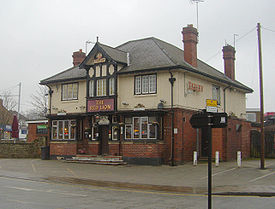
at a height of 192 metres above sea level beneath the Red Lion public house
Public house
A public house, informally known as a pub, is a drinking establishment fundamental to the culture of Britain, Ireland, Australia and New Zealand. There are approximately 53,500 public houses in the United Kingdom. This number has been declining every year, so that nearly half of the smaller...
in the Gleadless Townend residential area at 53.3447°N 1.4256°W. The Brook runs in a culvert
Culvert
A culvert is a device used to channel water. It may be used to allow water to pass underneath a road, railway, or embankment. Culverts can be made of many different materials; steel, polyvinyl chloride and concrete are the most common...
from beneath the public house before emerging into the open on land between Seagrave Crescent and Lister Crescent. It initially flows NE going beneath housing to emerge on the Jaunty Park recreation and sports grounds as an insignificant and rubbish strewn stream running at the rear of the Birley Vale Industrial Estate. It is then joined by an unnamed stream which rises from a spring further up the park. After 1.5 km it passes under the A6135 (Birley Moor Road) and swings easterly, disappearing underground, as it flows for almost a kilometre through a culvert beneath the former Normanton Spring landfill site which has now been landscaped and planted with trees. The brook emerges and continues its journey east going through Wickfield Heath and under the A57 road
A57 road
The A57 is a major road in England. It runs east from Liverpool to Lincoln, via Warrington, Cadishead, Irlam, Patricroft, Eccles, Salford and Manchester, then through the Pennines over the Snake Pass , around the Ladybower Reservoir, through Sheffield and past Worksop...
(Mosborough Parkway) before flowing through the Shire Brook Valley Local Nature Reserve on the northern side of the A57.
At this point the brook receives its only sizeable tributary, an unnamed stream which rises at Birley Spa at a height of 100 metres above sea level, flowing NE down a gorge for a kilometre to the Shire Brook valley. The Shire Brook then disappears underground again as it runs beneath the former Beighton Road landfill site just to the north of Beighton before entering an area of wetland
Wetland
A wetland is an area of land whose soil is saturated with water either permanently or seasonally. Wetlands are categorised by their characteristic vegetation, which is adapted to these unique soil conditions....
rich in bird life known as Beighton Marsh. The final 200 metres of Shire Brook’s journey before it joins the Rother is again through an underground culvert beneath the site of the former Woodhouse Junction railway sidings
Rail siding
A siding, in rail terminology, is a low-speed track section distinct from a running line or through route such as a main line or branch line or spur. It may connect to through track or to other sidings at either end...
which is now disused brownfield land
Brownfield land
Brownfield sites are abandoned or underused industrial and commercial facilities available for re-use. Expansion or redevelopment of such a facility may be complicated by real or perceived environmental contaminations. Cf. Waste...
which was being considered by Network Rail
Network Rail
Network Rail is the government-created owner and operator of most of the rail infrastructure in Great Britain .; it is not responsible for railway infrastructure in Northern Ireland...
as a location for a new National Engineering Centre before plans were rejected in April 2008. Shire Brook enters the River Rother at a height of 37 metres above sea level at approximately 53.3562°N 1.3394°W.
Ancient boundary
Shire Brook has been an important boundary line for over a thousand years. In Anglo-SaxonAnglo-Saxons
Anglo-Saxon is a term used by historians to designate the Germanic tribes who invaded and settled the south and east of Great Britain beginning in the early 5th century AD, and the period from their creation of the English nation to the Norman conquest. The Anglo-Saxon Era denotes the period of...
times the Brook formed the boundary between the kingdoms of Mercia
Mercia
Mercia was one of the kingdoms of the Anglo-Saxon Heptarchy. It was centred on the valley of the River Trent and its tributaries in the region now known as the English Midlands...
and Northumbria
Northumbria
Northumbria was a medieval kingdom of the Angles, in what is now Northern England and South-East Scotland, becoming subsequently an earldom in a united Anglo-Saxon kingdom of England. The name reflects the approximate southern limit to the kingdom's territory, the Humber Estuary.Northumbria was...
. For 900 years the Brook marked the division between Yorkshire
Yorkshire
Yorkshire is a historic county of northern England and the largest in the United Kingdom. Because of its great size in comparison to other English counties, functions have been increasingly undertaken over time by its subdivisions, which have also been subject to periodic reform...
and Derbyshire
Derbyshire
Derbyshire is a county in the East Midlands of England. A substantial portion of the Peak District National Park lies within Derbyshire. The northern part of Derbyshire overlaps with the Pennines, a famous chain of hills and mountains. The county contains within its boundary of approx...
, this gave the Brook its name, it was also known informally as County Brook and Der Brook, Der being short for Derbyshire. Another alternative name for the brook was Ochre
Ochre
Ochre is the term for both a golden-yellow or light yellow brown color and for a form of earth pigment which produces the color. The pigment can also be used to create a reddish tint known as "red ochre". The more rarely used terms "purple ochre" and "brown ochre" also exist for variant hues...
Dike, this was due to the run off from mines in the valley which made the water a yellow brown colour. In 1967 the City of Sheffield expanded its borders south to take in the suburbs of Hackenthorpe and Mosborough
Mosborough
Mosborough ward — which includes the districts of Halfway, Mosborough village, Waterthorpe, and Westfield — is one of the 28 electoral wards in City of Sheffield, England. It is located in the eastern part of the city, on the border with Rotherham, and covers an area of 8.9 km2....
and the Brook no longer marked the frontier between the two counties. The Brook also marks the boundary between the Ecclesiastical provinces of York
Archbishop of York
The Archbishop of York is a high-ranking cleric in the Church of England, second only to the Archbishop of Canterbury. He is the diocesan bishop of the Diocese of York and metropolitan of the Province of York, which covers the northern portion of England as well as the Isle of Man...
and Canterbury
Archbishop of Canterbury
The Archbishop of Canterbury is the senior bishop and principal leader of the Church of England, the symbolic head of the worldwide Anglican Communion, and the diocesan bishop of the Diocese of Canterbury. In his role as head of the Anglican Communion, the archbishop leads the third largest group...
.
Former industry
Up to the early 18th century the Shire Brook valley was mostly an agricultural area. However sustained industrial development came into the valley at the start of the 18th century and actually started in TudorTudor dynasty
The Tudor dynasty or House of Tudor was a European royal house of Welsh origin that ruled the Kingdom of England and its realms, including the Lordship of Ireland, later the Kingdom of Ireland, from 1485 until 1603. Its first monarch was Henry Tudor, a descendant through his mother of a legitimised...
times when Christopher Chapman was producing cutlery at Carr Forge in the mid-16th century.
Like many of Sheffield’s water courses, the Shire Brook’s water power was harnessed for turning Water wheel
Water wheel
A water wheel is a machine for converting the energy of free-flowing or falling water into useful forms of power. A water wheel consists of a large wooden or metal wheel, with a number of blades or buckets arranged on the outside rim forming the driving surface...
s for industry before the coming of steam and electricity. During the 19th century there were five wheels operating in the valley producing power to sharpen scythe
Scythe
A scythe is an agricultural hand tool for mowing grass, or reaping crops. It was largely replaced by horse-drawn and then tractor machinery, but is still used in some areas of Europe and Asia. The Grim Reaper is often depicted carrying or wielding a scythe...
s and sickle
Sickle
A sickle is a hand-held agricultural tool with a variously curved blade typically used for harvesting grain crops or cutting succulent forage chiefly for feeding livestock . Sickles have also been used as weapons, either in their original form or in various derivations.The diversity of sickles that...
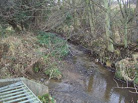
s. Several of the small mill ponds that once fed the water wheels still exist along the course of the river. The Upper and Lower Sickle wheels were in the Normanton Spring area, about 1.5 km from the Brook’s source. Further downstream were Carr Forge and Rainbow Forge while the Cliff Wheel was located just under a kilometre from the Brooks confluence with the River Rother. The dam at Rainbow Forge no longer holds water and its embankments and stonework are difficult to find amongst the undergrowth. Carr Forge Dam is the best preserved area of water in the valley although its wheel and cottages have now vanished. The site of the Lower Sickle Wheel (also known as Nether Wheel) was excavated in 1988 revealing the foundations of the mill buildings and the pits which held the grinding wheels.
Small scale coal mining
Coal mining
The goal of coal mining is to obtain coal from the ground. Coal is valued for its energy content, and since the 1880s has been widely used to generate electricity. Steel and cement industries use coal as a fuel for extraction of iron from iron ore and for cement production. In the United States,...
took place in the valley from the early 18th century, however it was not until the opening of the Birley Collieries
Birley Collieries
The Birley Collieries were a group of coal mines set in the Shire Brook Valley in south east Sheffield, South Yorkshire, England. They were connected to the railway system by a branch line from the Manchester, Sheffield and Lincolnshire Railway at Woodhouse East Junction, about 800 yards east of...
that large amounts of coal were extracted. Birley West Colliery was located just to the south of Normanton Spring, production lasted from 1855 until 1908. Birley East, situated between Hackenthorpe and Woodhouse opened in 1888 and operated until 1948. Shire Brook was culverted under both locations which became landfill sites when the pits closed. Both landfill sites have been capped off and landscaped in recent years.
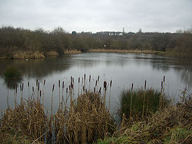
Shire Brook Valley Local Nature Reserve
The Shire Brook Valley Local Nature ReserveLocal Nature Reserve
Local nature reserve or LNR is a designation for nature reserves in the United Kingdom. The designation has its origin in the recommendations of the Wild Life Conservation Special Committee which established the framework for nature conservation in the United Kingdom and suggested a national suite...
was established in 1999 and extends over an area of approximately 100 hectares. The reserve is based around the former site of the Coisley Hill Sewage Works which closed in the early 1990s. The managers office has been converted into a visitors centre. The reserve includes Beighton Marsh, an area of reed-grass swamp, situated at its eastern end, which supports birds such as Reed Bunting
Reed Bunting
The Reed Bunting, Emberiza schoeniclus, is a passerine bird in the bunting family Emberizidae, a group now separated by most modern authors from the finches, Fringillidae....
, Grasshopper Warbler
Grasshopper Warbler
The Grasshopper Warbler, Locustella naevia, is an Old World warbler in the grass warbler genus Locustella. It breeds across much of temperate Europe and Asia. It is migratory, wintering from northwest Africa to India....
and Barn Owl
Barn Owl
The Barn Owl is the most widely distributed species of owl, and one of the most widespread of all birds. It is also referred to as Common Barn Owl, to distinguish it from other species in the barn-owl family Tytonidae. These form one of two main lineages of living owls, the other being the typical...
, as well as mammals such as Harvest Mouse
Harvest Mouse
The Harvest Mouse, Micromys minutus, is a small rodent native to Europe and Asia. It is typically found in fields of cereal crops such as wheat and oats, in reed beds and in other tall ground vegetation such as long grass and hedgerows. It has reddish-brown fur with white underparts and a naked,...
and Water Vole. The Birley Spa
Birley Spa
Birley Spa is a community bath hall and a Victorian bathhouse in the Hackenthorpe district of the City of Sheffield, England. It was built for Charles Herbert Pierrepont, 2nd Earl Manvers and the Lord of the Manor of Beighton in 1842, and initially was a hotel with spa baths beneath. Subsequently...
Bath House, a grade II listed building was restored with a Heritage Lottery Fund
Heritage Lottery Fund
The Heritage Lottery Fund is a fund established in the United Kingdom under the National Lottery etc. Act 1993. The Fund opened for applications in 1994. It uses money raised through the National Lottery to transform and sustain the UK’s heritage...
grant in 2001. Also within the reserve is Wickfield Plantation, one of the few remaining areas of lowland heath
Heath (habitat)
A heath or heathland is a dwarf-shrub habitat found on mainly low quality acidic soils, characterised by open, low growing woody vegetation, often dominated by plants of the Ericaceae. There are some clear differences between heath and moorland...
and coppiced
Coppicing
Coppicing is a traditional method of woodland management which takes advantage of the fact that many trees make new growth from the stump or roots if cut down. In a coppiced wood, young tree stems are repeatedly cut down to near ground level...
oak
Oak
An oak is a tree or shrub in the genus Quercus , of which about 600 species exist. "Oak" may also appear in the names of species in related genera, notably Lithocarpus...
woodland inside Sheffield. The Reserve contain Carr Forge Dam which is fed by the stream which comes down from Birley Spa and is a valuable location for wildlife. New ponds were created in the same area in 1993 to mark the centenary of the City of Sheffield. The Centenary Ponds were opened by Clive Betts
Clive Betts
Clive James Charles Betts is a British Labour Party politician, who was the Member of Parliament for Sheffield Attercliffe from 1992 to 2010, when he became Member of Parliament for Sheffield South East.- Early life :...
on 18 June 1993
Pollution
The Shire Brook was heavily polluted for many years, as storm drainStorm drain
A storm drain, storm sewer , stormwater drain or drainage well system or simply a drain or drain system is designed to drain excess rain and ground water from paved streets, parking lots, sidewalks, and roofs. Storm drains vary in design from small residential dry wells to large municipal systems...
overflow took raw sewage into the brook and then into the River Rother which was known as one of the most polluted rivers in Europe in the early 1990s. In 2005/6 much work was done to control the overflow with several storm flow storage tanks built in the Shire Brook valley. Yorkshire Water
Yorkshire Water
Yorkshire Water is a water supply and treatment utility company servicing West Yorkshire, South Yorkshire, the East Riding of Yorkshire, part of North Lincolnshire, most of North Yorkshire and part of Derbyshire, in England. The company has its origins in the Yorkshire Water Authority, one of ten...
were fined £5,000 plus costs when pumps failed at the Linley Bank Sewage Pumping Station, Hackenthorpe on March 30 and 31, 2006 allowing untreated sewage to affect an 800 metre stretch of the brook.