
.gif)
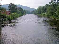
Shavers Fork (Cheat River)
Encyclopedia
Shavers Fork of the Cheat River
is situated in the Allegheny Mountains
of eastern West Virginia
, USA. It is 88.5 mi (142.5 km) long and forms the Cheat at its confluence
with Black Fork
at Parsons
. Its upper reaches are the highest river in the eastern United States.
and Ohio
Rivers, is part of the watershed
of the Mississippi River
, draining an area of 214 mi² (554 km²). It flows for much of its length through the Monongahela National Forest
, and drains mostly rural
and forest
ed areas. 97% of the river's basin is forested, and two-thirds of it is public land.
Shavers Fork rises in north-central Pocahontas County
at Thorny Flat, highest peak of Cheat Mountain
(4,848 ft/1,478 m) and the site of Snowshoe Mountain
ski resort. Its headwaters flow through the ghost town
of Spruce
. The river then flows generally north-northeastwardly through Randolph
and Tucker
Counties, where its valley is the trough between Cheat Mountain (to the west) and Shavers Mountain
(to the east). Settlements along its course include Cheat Bridge, Bemis, Bowden, and Porterwood. It ultimately joins the Black Fork at Parsons to form the Cheat at an elevation of 1621 ft (494 m).
 According to the Geographic Names Information System
, Shavers Fork has also been known historically as:
Cheat River
The Cheat River is a tributary of the Monongahela River in eastern West Virginia and southwestern Pennsylvania in the United States. Via the Monongahela and Ohio rivers, it is part of the Mississippi River watershed, ultimately draining into the Gulf of Mexico.-Geography:The Cheat is formed at...
is situated in the Allegheny Mountains
Allegheny Mountains
The Allegheny Mountain Range , also spelled Alleghany, Allegany and, informally, the Alleghenies, is part of the vast Appalachian Mountain Range of the eastern United States and Canada...
of eastern West Virginia
West Virginia
West Virginia is a state in the Appalachian and Southeastern regions of the United States, bordered by Virginia to the southeast, Kentucky to the southwest, Ohio to the northwest, Pennsylvania to the northeast and Maryland to the east...
, USA. It is 88.5 mi (142.5 km) long and forms the Cheat at its confluence
Confluence (geography)
In geography, a confluence is the meeting of two or more bodies of water. It usually refers to the point where two streams flow together, merging into a single stream...
with Black Fork
Black Fork (Cheat River)
The Black Fork is a principal tributary of the Cheat River in eastern West Virginia in the United States. It is a short stream, about four miles in length,The American Rivers Outstanding Rivers List, Second Edition, May 1991. Compiled and edited by Matthew H. Huntington and John D. Echeverria. ...
at Parsons
Parsons, West Virginia
The town of Parsons is the county seat of Tucker County, West Virginia, in the United States. The population was 1,463 at the 2000 census. The mayor of Parsons is Dorothy Judy and the city administrator is Jason Myers...
. Its upper reaches are the highest river in the eastern United States.
Geography
Shavers Fork, via the Cheat, MonongahelaMonongahela River
The Monongahela River is a river on the Allegheny Plateau in north-central West Virginia and southwestern Pennsylvania in the United States...
and Ohio
Ohio River
The Ohio River is the largest tributary, by volume, of the Mississippi River. At the confluence, the Ohio is even bigger than the Mississippi and, thus, is hydrologically the main stream of the whole river system, including the Allegheny River further upstream...
Rivers, is part of the watershed
Drainage basin
A drainage basin is an extent or an area of land where surface water from rain and melting snow or ice converges to a single point, usually the exit of the basin, where the waters join another waterbody, such as a river, lake, reservoir, estuary, wetland, sea, or ocean...
of the Mississippi River
Mississippi River
The Mississippi River is the largest river system in North America. Flowing entirely in the United States, this river rises in western Minnesota and meanders slowly southwards for to the Mississippi River Delta at the Gulf of Mexico. With its many tributaries, the Mississippi's watershed drains...
, draining an area of 214 mi² (554 km²). It flows for much of its length through the Monongahela National Forest
Monongahela National Forest
The Monongahela National Forest is a national forest located in the Allegheny Mountains of eastern West Virginia, USA. It protects over of federally-owned land within a proclamation boundary that includes much of the Potomac Highlands Region and portions of 10 counties.The MNF includes some...
, and drains mostly rural
Rural
Rural areas or the country or countryside are areas that are not urbanized, though when large areas are described, country towns and smaller cities will be included. They have a low population density, and typically much of the land is devoted to agriculture...
and forest
Forest
A forest, also referred to as a wood or the woods, is an area with a high density of trees. As with cities, depending where you are in the world, what is considered a forest may vary significantly in size and have various classification according to how and what of the forest is composed...
ed areas. 97% of the river's basin is forested, and two-thirds of it is public land.
Shavers Fork rises in north-central Pocahontas County
Pocahontas County, West Virginia
As of the census of 2000, there were 9,131 people, 835 households, and 527 families residing in the county. The population density was 10 people per square mile . There were 7,594 housing units at an average density of 8 per square mile...
at Thorny Flat, highest peak of Cheat Mountain
Cheat Mountain
Cheat Mountain is an exceptionally high and rugged ridge situated in the Allegheny Mountains of eastern West Virginia, USA. It is about long and more than five miles wide at its widest. Its highest point is at its southernmost end at Thorny Flat, which has an elevation of...
(4,848 ft/1,478 m) and the site of Snowshoe Mountain
Snowshoe Mountain
Snowshoe Mountain is a ski resort in Snowshoe, West Virginia. The resort has skiable terrain across and covers a total area of in the Allegheny Mountains, which are a part of the vast Appalachian Mountain Range. It is positioned in the bowl shaped convergence of two mountains, Cheat and Back...
ski resort. Its headwaters flow through the ghost town
Ghost town
A ghost town is an abandoned town or city. A town often becomes a ghost town because the economic activity that supported it has failed, or due to natural or human-caused disasters such as floods, government actions, uncontrolled lawlessness, war, or nuclear disasters...
of Spruce
Spruce, West Virginia
Spruce is an unincorporated community in Pocahontas County, West Virginia, United States. Spruce is southwest of Durbin....
. The river then flows generally north-northeastwardly through Randolph
Randolph County, West Virginia
As of the census of 2000, there were 28,262 people, 11,072 households, and 7,661 families residing in the county. The population density was 27 people per square mile . There were 13,478 housing units at an average density of 13 per square mile...
and Tucker
Tucker County, West Virginia
As of the census of 2000, there were 7,321 people, 3,052 households, and 2,121 families residing in the county. The population density was 18 people per square mile . There were 4,634 housing units at an average density of 11 per square mile...
Counties, where its valley is the trough between Cheat Mountain (to the west) and Shavers Mountain
Shavers Mountain
Shavers Mountain, is a high and rugged ridge situated in the Allegheny Mountains of eastern West Virginia. It is about long, north to south, and several of its peaks exceed in elevation...
(to the east). Settlements along its course include Cheat Bridge, Bemis, Bowden, and Porterwood. It ultimately joins the Black Fork at Parsons to form the Cheat at an elevation of 1621 ft (494 m).
Variant names and spellings
Geographic Names Information System
The Geographic Names Information System is a database that contains name and locative information about more than two million physical and cultural features located throughout the United States of America and its territories. It is a type of gazetteer...
, Shavers Fork has also been known historically as:
- Chavers Fork
- Main Cheat River
- Shafers Fork
- Shaffers Fork of Cheat River
- Shaver's Fork
- Shavers Fork River
- Shavers Fork of Cheat River