

Seerhein
Encyclopedia
The Seerhein is a river of about four kilometer long, in the basin of Lake Constance
. It is the outflow of the Upper Lake Constance
and the main tributary of the Lower Lake Constance
. The water level of the lower lake is about 30 cm below the level of the Upper Lake. It is considered part of the Rhine, which flows into Lake Constance as the Alpine Rhine and flows out of the Lake as the High Rhine
. The Seerhein arose after the last Ice Age
(the Würm glaciation, about 9650 BCE). Some time after this period, the water level of Lake Constance gradually dropped by about ten meters and the shallow parts fell dry. Some parts of the Seerhein still have a character a bit like a lake.
The border between Germany
and Switzerland
runs down the center of the lower stretch of the river; the German city of Constance
, the largest community on the river, is situated on both sides of the upper part.
across the Rhine in Constance in the east to the island of Triboldingerbohl
in the west. Narrow side channels extend between this island, the island of and the Wollmatinger Ried. The Seerhein is between 100 and 500 meters wide and between 7 and 25 meters deep. About halfway, there is a unnamed, shallow, widening, which looks a bit like a small lake. The Seerhein has some small streams as tributaries, both on the left side: the Dorfbach near Gottlieben
and the Grenzbach ("Border Brook") on the western city limits of Constance.
Most of the river, including the entire north shore and the eastern part of the southern shore, is located on German territory. On the western two kilometers, the border between Germany and Switzerland runs through the middle of the river. On the Swiss side the minucipalties of Tägerwilen
and Gottlieben
border the river; the German side the city of Constance and the Landkreis of municipality of Reichenau
. The Swiss city of Kreuzlingen
is considered part of the agglomeration
centered on Constance. On the South bank, we find the old city center of Constance and the former villages of Paradies
; the desnsely populated area between these centers was built up in the 19th and 20th Centuries. On the Swiss part of the South bank, we find the villages of Gottlieben and Tägermoos
. Tägermoos is politically in the Swiss municipality of Tägerwilen, but the City of Constance participates in its administration. On the North bank, we find Petershausen and Stromeyersdorf; both are now districts of Constance. Also found on the North bank is "Zugwiesen", an exclave of the municipality of Reichenau.
The embankments in the urban area of Constance are sometimes used to moor boats. The North bank has experienced very active construction in recent years. Industrial estates were demolished and replaced by residential estates, with parks along the river. The inner city "Rhine Beach" is also situated on the North bank. Outside the city, the banks are unimproved. There are two places where swimming is permitted: the "Konstanzer Kuhhorn" in Tägermoos and the pool in Tägerwilen. The Western part of the North bank (known as the "Wollmatinger Ried") is swampy and overgrown with cane
, and the same holds for the Swiss bank West of Gottlieben. Due to their size and tranquility, these marshlands are of major ecological importance.
Historically interesting buildings in the Seerhein area are remains of the fortifications of Constance (Rhine Gate Tower and Powder Tower), the Petershausen Abbey
, the Gottlieben Castle
and former factories in Stromeyersdorf.
.
The name Konstanzer Niederung is a contribution by Benting. It derives from his description of the Natural regions of Germany, in which the Niederung appeared as a natural subunit.
The Swiss call the depression Seetal ("Lake Valley"). This name is used in names like Schulzentrum Seetal ("Seetal School'), Pumpwerk Seetal ("Seetal Pumping Station"), Seetalstrasse ("Seetal Street"), all found in Kreuzlingen. In a Swiss list of regions, Schilter included the Seetal in the Uferlandschaft ("River Bank Area"), which stretches all the way to the Romanshorn
.
 The Seerhein is navigable and is used primarily by the pleasure boats of the "Schweizerischen Schifffahrtsgesellschaft Untersee und Rhein" ("Swiss Shipping Company 'Untersee and Rhine').
There are three bridges
across the Seerhein, all on the upper part of the river. Furthest East is the Old Rhine Bridge
in Constance, near the bottleneck of the terminal moraine (see below). The current bridge was constructed in 1957, but precursors have existed since late antiquity. A little to the West, the Seerheinbrücke, a pedestrian and cycle bridge, was built in 1991. At the Western edge of Contance, the Schänzlebrücke crosses the river. It is part of the German Federal Highway 33, which turns in to Highway A7 at the border.
There used to be several ferries, one to the East of the present cycle bridge, and one between Paradies and Stromeyersdorf. In the 19th Century, distance markers where placed along the Rhine; they start counting Kilometers at the Old Bridge in Constance.
basin, which was formed during the Upper Miocene about 30 million years ago. In the next 7 million years (until now) the sedimentation
exceeded the erosion
. During this timeframe, the present landscape was formed. During the Pliocene
and Pleistocene
, erosion was dominated by the Aare and Danube
, later by the High Rhine
. Rivers and glaciers created furrows and basins.
The paleogeographic development of the Seerhein is closely connected to that of the valley through which it flows. This valley was created by the early High Rhine and the Rhine glacier and filled by different lake deposits. The entire Lake basin is characterized by the alternation of the wide basin, narrow cross valleys and mountainous landscapes. The lowlands surrounding the Seerhein are largely the result of siltation and is one of the basin landscapes; the neighbouring hill ranges Bodanrück and Seerücken are glacial molasses highlands.
A decisive step in the formation of today's Seerhein and Lake Constance area took place with the deflection of the Alpine Rhine from the Danube to the Aar during Günz ice age
. On the line Lake Constance-Seerhein-High Rhine enhanced vertical erosion followed, while the advancing Rhine glacier prepared today's Lake basin.
 The retreat of the Rhine glacier (at the end of the Würm
ice age) occurred as a number of melting and stationary phases, which are conventionally divided into nine stages. Stage 9, the "Constance" stage, begins with the edge of the ice at a standstill near Constance. The ice edge east of the glacier was along a line from the Lake Überlingen
via the eastern tip of Bodanrück, through Constance and Kreuzlingen to the northern end of the Seerücken.
Early in the Constance stage, a proglacial lake
formed in the area of today's Seerhein basin and to the west of it. In this lake, extensive silty calcareous, glacilimnic layers were deposited. These appear on the surface in some places on the edge of the valley. After the Ice lake disappeared, a terminal moraine
was formed, which later turned out to be important for the course of human settlement (see below). Initially, the melt water from the Lake Überlingen basin flowed through Staringen Valley; later it flowed through the Allmannsdorf melt water channel in the area of today's Seerhein depression. A melt period followed, in which all ice in the Konstanzer Trichter and Obersee melted.
After the end of the Würm Ice Age (about 9650 BC) the water level of Lake Constance was at about 405 m above the current sea level, or about 10 meter above the present level. Back then, the Seerhein valley was submerged and Lake Constance was a single lake. Deep erosion of the Rhine then lowered the lake to its current level (about 395 m). The Seerhein valley fell dry; the Upper and Lower were Lake separated, and the Seerhein emerged as the connection between the two lakes. The course of the present Seerhein may well correspond to the location of the current in the days when Lake Constance was a single lake. The former extent of the lake is indicated by typical lake deposits; in the Seerhein valley, such deposits are found all over the valley floor. These lake sediments usually have a thickness of 0.2 to 2 meters, near the Seerhein up to 13 meters. In the western part of today's depression, the surf
of the lake formed many beach ridges perpendicular to the main wind direction (southwest); ridges in the Wollmatinger Ried are still well preserved. Besides the described main elements (Würm moraine, Ice Lake sediments, Lake deposits, including the beach ridges), Pleistocene talus and Holocene alluvial fan
are found in Seerhein basin.
Originally, most of the basin floor was swampy or even rather wet. The moraines, however, were suitable for human settlement. The moraine of Constance has been the location of several prehistoric and early historic settlement, among them a Roman
predecessor of Constance. Large parts of today's old town of Constance are on the terminal moraine, and the north-south direction of the old town is due to the direction of the moraine. By contract, Stadelhofen, the southernmost town of the Constance area, was built on the former lake bed. In Kreuzlingen, the moraine extends along the Hauptstrasse ("Main Street"), roughly from the border to the intersection with Remisbergstrasse. Both the old and the new location of the monastery at Kreuzlingen are in the area of the moraine.
In the context of the tow-part Lake Constance, the Seerhein present a suitable point to construct a bridge or a ferry and to found a port town. The best place to cross the river was probably the terminal moraine bottleneck at the beginning of the Seerhein. Celtic, Roman and Alemannic
, the Diocese of Constance and the Imperial Free City Constance tried to use this strategic position.
In the ancient world, the Seerhein marked the northern boundary of the Roman Empire for a while. In the early Middle Ages, he was the boundary between the legislative areas of Thurgau
and Hegau
and the northern boundary of the City of Constance. Petershausen, on the north bank opposite Constance, was founded in 983 and later became a suburb, before it was annexed by the city. The monstery was founded on the opposite bank of the Seerhien, by analogy with St. Peter's basilica in Rome
, with was built on the "other" side of the Tiber
.
During the Middle Ages, the river bank was fortified by a city wall with several towers, which was partially built on the river. It was connected to the north bank by a stone bridge. The was a grain mill
on the bridge, driven by the river. The north banks were not improved, until the area was developed for industrial uses in the 19th Century.
, i.e. standing wave
, in which the entire lake resonates at its natural frequency. As it happens, Constance is close to an anti-node in this wave, making the effect especially visible.http://physik.uni-graz.at/~cbl/C+P/contents/Stud-WS02/schuetky/mehrgitterverfahren.htm
Lake Constance
Lake Constance is a lake on the Rhine at the northern foot of the Alps, and consists of three bodies of water: the Obersee , the Untersee , and a connecting stretch of the Rhine, called the Seerhein.The lake is situated in Germany, Switzerland and Austria near the Alps...
. It is the outflow of the Upper Lake Constance
Obersee (Lake Constance)
The Obersee the larger of the two parts of Lake Constance.It has an area of 473 km² in size and extends over 63 km between Bregenz and Bodman-Ludwigshafen. Its maximum width is 14 km. The Romans called it Lacus Venetus, Lacus Brigantinus and Lacus Constantinus...
and the main tributary of the Lower Lake Constance
Untersee (Lake Constance)
The Untersee is the smaller of the two lakes that together form Lake Constance and forms part of the boundary between Switzerland and Germany.- Geography :...
. The water level of the lower lake is about 30 cm below the level of the Upper Lake. It is considered part of the Rhine, which flows into Lake Constance as the Alpine Rhine and flows out of the Lake as the High Rhine
High Rhine
The High Rhine is the name used in Germany for the part of the Rhine River that flows westbound from Lake Constance to Basel.The High Rhine begins at the outflow of the Rhine from the Untersee in Stein am Rhein and turns into the Upper Rhine in Basel...
. The Seerhein arose after the last Ice Age
Ice age
An ice age or, more precisely, glacial age, is a generic geological period of long-term reduction in the temperature of the Earth's surface and atmosphere, resulting in the presence or expansion of continental ice sheets, polar ice sheets and alpine glaciers...
(the Würm glaciation, about 9650 BCE). Some time after this period, the water level of Lake Constance gradually dropped by about ten meters and the shallow parts fell dry. Some parts of the Seerhein still have a character a bit like a lake.
The border between Germany
Germany
Germany , officially the Federal Republic of Germany , is a federal parliamentary republic in Europe. The country consists of 16 states while the capital and largest city is Berlin. Germany covers an area of 357,021 km2 and has a largely temperate seasonal climate...
and Switzerland
Switzerland
Switzerland name of one of the Swiss cantons. ; ; ; or ), in its full name the Swiss Confederation , is a federal republic consisting of 26 cantons, with Bern as the seat of the federal authorities. The country is situated in Western Europe,Or Central Europe depending on the definition....
runs down the center of the lower stretch of the river; the German city of Constance
Constance
Constance is a female given name that derives from Latin and means "constant." Variations of the name include Connie, Constancia, Constanze, Constanza, Stanzy, and Konstanze.Constance may refer to:-People:*Constance Bennett , American actress...
, the largest community on the river, is situated on both sides of the upper part.
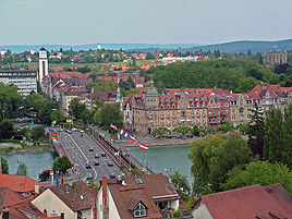
General
The Seerhein extends over a length of 4.3 km from the old bridgeOld Rhine Bridge (Constance)
The Old Rhine Bridge at Constance spans in the Seerhein. It is a combined road and railway bridge. In addition to one track of the Upper Rhine Railway at kilometer 413.5, it carries the , the road that connects the borough of Petershausen with the city center. The road bridge carries two lanes...
across the Rhine in Constance in the east to the island of Triboldingerbohl
Triboldingerbohl
Triboldingerbohl, also known as Triboltingen or großes Bohl or Langenrain, is the fourth largest island of Lake Constance, with an area of 0.13557 km². It is 780 meters long and up to 230 meters wide. It is located in the easternmost part of the Untersee , near the point where the Seerhein...
in the west. Narrow side channels extend between this island, the island of and the Wollmatinger Ried. The Seerhein is between 100 and 500 meters wide and between 7 and 25 meters deep. About halfway, there is a unnamed, shallow, widening, which looks a bit like a small lake. The Seerhein has some small streams as tributaries, both on the left side: the Dorfbach near Gottlieben
Gottlieben
Gottlieben is a municipality in the district of Kreuzlingen in the canton of Thurgau in Switzerland.-History:Gottlieben is first mentioned around the end of the 10th Century as Gotiliubon. It was originally part of the land owned by the Bishop of Constance. In 1251, Eberhard von Waldburg built a...
and the Grenzbach ("Border Brook") on the western city limits of Constance.
Most of the river, including the entire north shore and the eastern part of the southern shore, is located on German territory. On the western two kilometers, the border between Germany and Switzerland runs through the middle of the river. On the Swiss side the minucipalties of Tägerwilen
Tägerwilen
Tägerwilen is a municipality in the district of Kreuzlingen in the canton of Thurgau in Switzerland.-Geography:Tägerwilen has an area, , of . Of this area, or 47.5% is used for agricultural purposes, while or 37.4% is forested...
and Gottlieben
Gottlieben
Gottlieben is a municipality in the district of Kreuzlingen in the canton of Thurgau in Switzerland.-History:Gottlieben is first mentioned around the end of the 10th Century as Gotiliubon. It was originally part of the land owned by the Bishop of Constance. In 1251, Eberhard von Waldburg built a...
border the river; the German side the city of Constance and the Landkreis of municipality of Reichenau
Reichenau, Baden-Württemberg
Reichenau is a municipality in the district of Konstanz in Baden-Württemberg in Germany. It is located partly on Reichenau Island with its famous abbey and on the northern shore of the Untersee section of Lake Constance. The island has historically been the center of the community. The...
. The Swiss city of Kreuzlingen
Kreuzlingen
Kreuzlingen is a municipality in the district of Kreuzlingen in the canton of Thurgau in north-eastern Switzerland. It is the seat of the district and is the second largest city of the canton, after Frauenfeld, with a population of over 18,000...
is considered part of the agglomeration
Agglomeration
In the study of human settlements, an urban agglomeration is an extended city or town area comprising the built-up area of a central place and any suburbs linked by continuous urban area. In France, INSEE the French Statistical Institute, translate it as "Unité urbaine" which means continuous...
centered on Constance. On the South bank, we find the old city center of Constance and the former villages of Paradies
Paradies (Constance)
Paradies is a former village, now a quarter of Konstanz, Germany. The district is located west of the Old Town on the southern shore of the Seerhein; with an area of about 63.2 hectare and 6176 inhabitants ....
; the desnsely populated area between these centers was built up in the 19th and 20th Centuries. On the Swiss part of the South bank, we find the villages of Gottlieben and Tägermoos
Tägermoos
The Tägermoos is an area of 1.54 km² in Thurgau, Switzerland, wedged between the outskirts of the German city of Constance and the core village the Swiss municipality Tägerwilen. It lies on the south bank of the Seerhein. In the east, it borders the district Paradies of Constance...
. Tägermoos is politically in the Swiss municipality of Tägerwilen, but the City of Constance participates in its administration. On the North bank, we find Petershausen and Stromeyersdorf; both are now districts of Constance. Also found on the North bank is "Zugwiesen", an exclave of the municipality of Reichenau.
The embankments in the urban area of Constance are sometimes used to moor boats. The North bank has experienced very active construction in recent years. Industrial estates were demolished and replaced by residential estates, with parks along the river. The inner city "Rhine Beach" is also situated on the North bank. Outside the city, the banks are unimproved. There are two places where swimming is permitted: the "Konstanzer Kuhhorn" in Tägermoos and the pool in Tägerwilen. The Western part of the North bank (known as the "Wollmatinger Ried") is swampy and overgrown with cane
Cane
Cane are either of two genera of tall, perennial grasses with flexible, woody stalks from the family Poaceae that grow throughout the world in wet soils. They are related to and may include species of bamboo. The genus Arundo is native from the Mediterranean region to the Far East. Arundinaria...
, and the same holds for the Swiss bank West of Gottlieben. Due to their size and tranquility, these marshlands are of major ecological importance.
Historically interesting buildings in the Seerhein area are remains of the fortifications of Constance (Rhine Gate Tower and Powder Tower), the Petershausen Abbey
Petershausen Abbey
Petershausen Abbey was a Benedictine monastery at Petershausen, now a district of Konstanz in Baden-Württemberg, Germany.-History:...
, the Gottlieben Castle
Gottlieben Castle
Gottlieben Castle is a castle in the municipality of Gottlieben in the canton of Thurgau in Switzerland. It is a Swiss heritage site of national significance.-History:...
and former factories in Stromeyersdorf.
Seerhein valley
The Seerhein flows through a depression which is known as Seetal ("Lake Valley") or Konstanzer Niederung ("Constance Depression"). This valley is bordered on the south by the Seerücken ("Lake Ridge") and to the north from the hill country of the BodanrückBodanrück
The Bodanrück is the peninsula that divides Lake Constance into Überlinger See and Gnadensee, which is part of Untersee.The cities of Konstanz, Radolfzell and Allensbach are located there.- External links :*...
.
The name Konstanzer Niederung is a contribution by Benting. It derives from his description of the Natural regions of Germany, in which the Niederung appeared as a natural subunit.
The Swiss call the depression Seetal ("Lake Valley"). This name is used in names like Schulzentrum Seetal ("Seetal School'), Pumpwerk Seetal ("Seetal Pumping Station"), Seetalstrasse ("Seetal Street"), all found in Kreuzlingen. In a Swiss list of regions, Schilter included the Seetal in the Uferlandschaft ("River Bank Area"), which stretches all the way to the Romanshorn
Romanshorn
Romanshorn is a municipality in the district of Arbon in the canton of Thurgau in Switzerland.-History:Romanshorn was probably settled in the 7th Century, and is first mentioned in 779 as Rumanishorn in a land grant from Waldrata to the Abbey of St. Gall. During the Late Middle Ages and until...
.
Transport
There are three bridges
Bridges
-People:* Alexander Bridges, English footballer* Angelica Bridges , American actress, model and singer* Barry Bridges , English footballer* Beau Bridges , American actor* Bles Bridges , South African singer...
across the Seerhein, all on the upper part of the river. Furthest East is the Old Rhine Bridge
Old Rhine Bridge (Constance)
The Old Rhine Bridge at Constance spans in the Seerhein. It is a combined road and railway bridge. In addition to one track of the Upper Rhine Railway at kilometer 413.5, it carries the , the road that connects the borough of Petershausen with the city center. The road bridge carries two lanes...
in Constance, near the bottleneck of the terminal moraine (see below). The current bridge was constructed in 1957, but precursors have existed since late antiquity. A little to the West, the Seerheinbrücke, a pedestrian and cycle bridge, was built in 1991. At the Western edge of Contance, the Schänzlebrücke crosses the river. It is part of the German Federal Highway 33, which turns in to Highway A7 at the border.
There used to be several ferries, one to the East of the present cycle bridge, and one between Paradies and Stromeyersdorf. In the 19th Century, distance markers where placed along the Rhine; they start counting Kilometers at the Old Bridge in Constance.
Paleogeographic Development
The entire landscape of the Seerhein and its environment is in the range of MolasseMolasse
The term "molasse" refers to the sandstones, shales and conglomerates formed as terrestrial or shallow marine deposits in front of rising mountain chains. The molasse is deposited in a foreland basin, especially on top of flysch, for example that left from the rising Alps, or erosion in the Himalaya...
basin, which was formed during the Upper Miocene about 30 million years ago. In the next 7 million years (until now) the sedimentation
Sedimentation
Sedimentation is the tendency for particles in suspension to settle out of the fluid in which they are entrained, and come to rest against a barrier. This is due to their motion through the fluid in response to the forces acting on them: these forces can be due to gravity, centrifugal acceleration...
exceeded the erosion
Erosion
Erosion is when materials are removed from the surface and changed into something else. It only works by hydraulic actions and transport of solids in the natural environment, and leads to the deposition of these materials elsewhere...
. During this timeframe, the present landscape was formed. During the Pliocene
Pliocene
The Pliocene Epoch is the period in the geologic timescale that extends from 5.332 million to 2.588 million years before present. It is the second and youngest epoch of the Neogene Period in the Cenozoic Era. The Pliocene follows the Miocene Epoch and is followed by the Pleistocene Epoch...
and Pleistocene
Pleistocene
The Pleistocene is the epoch from 2,588,000 to 11,700 years BP that spans the world's recent period of repeated glaciations. The name pleistocene is derived from the Greek and ....
, erosion was dominated by the Aare and Danube
Danube
The Danube is a river in the Central Europe and the Europe's second longest river after the Volga. It is classified as an international waterway....
, later by the High Rhine
High Rhine
The High Rhine is the name used in Germany for the part of the Rhine River that flows westbound from Lake Constance to Basel.The High Rhine begins at the outflow of the Rhine from the Untersee in Stein am Rhein and turns into the Upper Rhine in Basel...
. Rivers and glaciers created furrows and basins.
The paleogeographic development of the Seerhein is closely connected to that of the valley through which it flows. This valley was created by the early High Rhine and the Rhine glacier and filled by different lake deposits. The entire Lake basin is characterized by the alternation of the wide basin, narrow cross valleys and mountainous landscapes. The lowlands surrounding the Seerhein are largely the result of siltation and is one of the basin landscapes; the neighbouring hill ranges Bodanrück and Seerücken are glacial molasses highlands.
A decisive step in the formation of today's Seerhein and Lake Constance area took place with the deflection of the Alpine Rhine from the Danube to the Aar during Günz ice age
Beestonian stage
The Beestonian Stage is the name for an early Pleistocene stage used in the British Isles. It precedes the Cromerian Stage and follows the Pastonian Stage. This stage consists of alternating glacial and interglacial phases instead of being a continuous glacial epoch. It is equivalent to the...
. On the line Lake Constance-Seerhein-High Rhine enhanced vertical erosion followed, while the advancing Rhine glacier prepared today's Lake basin.
Würm
The Würm is a river in Bavaria, Germany, right tributary of the Amper. It drains the overflow from Lake Starnberg and flows swiftly through the villages of Gauting, Krailling, Planegg, Gräfelfing and Lochham as well as part of Munich before joining, near Dachau, the Amper, which soon afterwards...
ice age) occurred as a number of melting and stationary phases, which are conventionally divided into nine stages. Stage 9, the "Constance" stage, begins with the edge of the ice at a standstill near Constance. The ice edge east of the glacier was along a line from the Lake Überlingen
Lake Überlingen
Lake Überlingen Lake is the northwestern "finger" of the Obersee part of Lake Constance. The boundary of lake is defined as the ferry link from Meersburg to Constance...
via the eastern tip of Bodanrück, through Constance and Kreuzlingen to the northern end of the Seerücken.
Early in the Constance stage, a proglacial lake
Proglacial lake
In geology, a proglacial lake is a lake formed either by the damming action of a moraine or ice dam during the retreat of a melting glacier, or by meltwater trapped against an ice sheet due to isostatic depression of the crust around the ice...
formed in the area of today's Seerhein basin and to the west of it. In this lake, extensive silty calcareous, glacilimnic layers were deposited. These appear on the surface in some places on the edge of the valley. After the Ice lake disappeared, a terminal moraine
Terminal moraine
A terminal moraine, also called end moraine, is a moraine that forms at the end of the glacier called the snout.Terminal moraines mark the maximum advance of the glacier. An end moraine is at the present boundary of the glacier....
was formed, which later turned out to be important for the course of human settlement (see below). Initially, the melt water from the Lake Überlingen basin flowed through Staringen Valley; later it flowed through the Allmannsdorf melt water channel in the area of today's Seerhein depression. A melt period followed, in which all ice in the Konstanzer Trichter and Obersee melted.
After the end of the Würm Ice Age (about 9650 BC) the water level of Lake Constance was at about 405 m above the current sea level, or about 10 meter above the present level. Back then, the Seerhein valley was submerged and Lake Constance was a single lake. Deep erosion of the Rhine then lowered the lake to its current level (about 395 m). The Seerhein valley fell dry; the Upper and Lower were Lake separated, and the Seerhein emerged as the connection between the two lakes. The course of the present Seerhein may well correspond to the location of the current in the days when Lake Constance was a single lake. The former extent of the lake is indicated by typical lake deposits; in the Seerhein valley, such deposits are found all over the valley floor. These lake sediments usually have a thickness of 0.2 to 2 meters, near the Seerhein up to 13 meters. In the western part of today's depression, the surf
Surf
Surf is the wave activity in the area between the shoreline and outer limit of breakers. It may refer to a breaking wave in shallow water, upon the shore, or in the area in which waves breakSurf also may refer to:Commercial products...
of the lake formed many beach ridges perpendicular to the main wind direction (southwest); ridges in the Wollmatinger Ried are still well preserved. Besides the described main elements (Würm moraine, Ice Lake sediments, Lake deposits, including the beach ridges), Pleistocene talus and Holocene alluvial fan
Alluvial fan
An alluvial fan is a fan-shaped deposit formed where a fast flowing stream flattens, slows, and spreads typically at the exit of a canyon onto a flatter plain. A convergence of neighboring alluvial fans into a single apron of deposits against a slope is called a bajada, or compound alluvial...
are found in Seerhein basin.
History
The end moraines in the Constance depression wer formed along the edge of the ice during the Constance stage (see above). In the area of the old town of Constance, we find a moraine surrounded by Lake deposits. The section of the moraine in Kreuzlingen, however, is surrounded predominantly by Pleistocene talus. Sections of the end moraine are found further north east and south east, in the area of the Bodanrück and Seerücken, respectively. Sections od end moraine connecting these to the Constance section may have been eroded away, or they may never have existed due to water movement during the Constance stage.Originally, most of the basin floor was swampy or even rather wet. The moraines, however, were suitable for human settlement. The moraine of Constance has been the location of several prehistoric and early historic settlement, among them a Roman
Roman Empire
The Roman Empire was the post-Republican period of the ancient Roman civilization, characterised by an autocratic form of government and large territorial holdings in Europe and around the Mediterranean....
predecessor of Constance. Large parts of today's old town of Constance are on the terminal moraine, and the north-south direction of the old town is due to the direction of the moraine. By contract, Stadelhofen, the southernmost town of the Constance area, was built on the former lake bed. In Kreuzlingen, the moraine extends along the Hauptstrasse ("Main Street"), roughly from the border to the intersection with Remisbergstrasse. Both the old and the new location of the monastery at Kreuzlingen are in the area of the moraine.
In the context of the tow-part Lake Constance, the Seerhein present a suitable point to construct a bridge or a ferry and to found a port town. The best place to cross the river was probably the terminal moraine bottleneck at the beginning of the Seerhein. Celtic, Roman and Alemannic
Alamanni
The Alamanni, Allemanni, or Alemanni were originally an alliance of Germanic tribes located around the upper Rhine river . One of the earliest references to them is the cognomen Alamannicus assumed by Roman Emperor Caracalla, who ruled the Roman Empire from 211 to 217 and claimed thereby to be...
, the Diocese of Constance and the Imperial Free City Constance tried to use this strategic position.
In the ancient world, the Seerhein marked the northern boundary of the Roman Empire for a while. In the early Middle Ages, he was the boundary between the legislative areas of Thurgau
Thurgau
Thurgau is a northeast canton of Switzerland. The population, , is . In 2007, there were a total of 47,390 who were resident foreigners. The capital is Frauenfeld.-History:...
and Hegau
Hegau
The Hegau is a formerly volcanic landscape in southern Germany extending around the industrial city of Singen , between Lake Constance in the east, the Rhine River in the south, the Danube River in the north and the Randen—as the southwestern mountains of the Swabian Alb are called—in the west.The...
and the northern boundary of the City of Constance. Petershausen, on the north bank opposite Constance, was founded in 983 and later became a suburb, before it was annexed by the city. The monstery was founded on the opposite bank of the Seerhien, by analogy with St. Peter's basilica in Rome
Rome
Rome is the capital of Italy and the country's largest and most populated city and comune, with over 2.7 million residents in . The city is located in the central-western portion of the Italian Peninsula, on the Tiber River within the Lazio region of Italy.Rome's history spans two and a half...
, with was built on the "other" side of the Tiber
Tiber
The Tiber is the third-longest river in Italy, rising in the Apennine Mountains in Emilia-Romagna and flowing through Umbria and Lazio to the Tyrrhenian Sea. It drains a basin estimated at...
.
During the Middle Ages, the river bank was fortified by a city wall with several towers, which was partially built on the river. It was connected to the north bank by a stone bridge. The was a grain mill
Gristmill
The terms gristmill or grist mill can refer either to a building in which grain is ground into flour, or to the grinding mechanism itself.- Early history :...
on the bridge, driven by the river. The north banks were not improved, until the area was developed for industrial uses in the 19th Century.
Water miracles of Constance
On 23 February 1549 the "water miracle of Constance" is reported to have happened: the Seerhein rose and fell over several hours at intervals of about a quarter of an hour by a ell, more than half a meter. Fishermen on the Lower Lake reported that the water of the Rhine appeared to flow backwards. Today, this event can be explained scientifically: Certain wind conditions induce waves at the natural frequency of the upper and lower lake. This creates a seicheSeiche
A seiche is a standing wave in an enclosed or partially enclosed body of water. Seiches and seiche-related phenomena have been observed on lakes, reservoirs, swimming pools, bays, harbors and seas...
, i.e. standing wave
Standing wave
In physics, a standing wave – also known as a stationary wave – is a wave that remains in a constant position.This phenomenon can occur because the medium is moving in the opposite direction to the wave, or it can arise in a stationary medium as a result of interference between two waves traveling...
, in which the entire lake resonates at its natural frequency. As it happens, Constance is close to an anti-node in this wave, making the effect especially visible.http://physik.uni-graz.at/~cbl/C+P/contents/Stud-WS02/schuetky/mehrgitterverfahren.htm
Sources
- Benzing, Alfred (1964): Natural regions on sheet 186: Constance, Bad Godesberg 1964 (Natural regions of Germany, Geographical Map 1:200,000)
- Shields, René Ch. (1977): Attempt at a landscape classification and typology of Switzerland, Zurich, 1977
- Schreiner, Albert (1992), Explanation of the sheet Hegau and Western Lake Constance, third edition, Freiburg / Stuttgart 1992 (1:50,000 Geological Map of Baden-Württemberg)