
Savanna Portage State Park
Encyclopedia
Savanna Portage State Park is a state park
of Minnesota
, USA, established in 1961 to preserve the historic Savanna Portage, a difficult 6 miles (9.7 km) trail connecting the watersheds of the Mississippi River
and Lake Superior
. The park contains a drainage divide separating the West Savanna River
, which drains to the Mississippi and the Gulf of Mexico
, from the East Savanna River
, which flows in an opposite direction to the Saint Louis River
, Lake Superior and the Great Lakes
, and the Saint Lawrence River
to the Atlantic Ocean
.
Savanna Portage was a canoe
portage
used by Native Americans
for centuries before being used by European explorers, fur trade
rs, Voyageurs
, coureurs des bois
, and missionaries of the 18th and 19th centuries. It was a vital link connecting the Mississippi waterways to the west with the Great Lakes
to the east. The portage is listed in the National Register of Historic Places
. The park which now contains it is located 17 miles (27.4 km) north and east of McGregor, Minnesota
, and approximately 50 miles (80.5 km) west of Duluth
.
s of the Great Lakes
and the Gulf of Mexico, both of which drain to the Atlantic Ocean
. The area is a low-relief plain which was once a glacial lake
bed. During the last phase of the Wisconsinan glaciation
, the deteriorating continental glacier left behind connected lakes, known as Glacial Lakes Aitkin and Upham. Formed by the retreat of the St. Louis Sublobe of the Superior Lobe of the glacier, Lake Upham drained through Lake Aitkin to the Mississippi River. The retreating glacier and the lakes deposited sand and sediments in the lakebed. As the lakes drained these sediments became the present plain.
The plain at first was drained by the Cloquet River
, which then ran west to the Mississippi. By the process of stream piracy, the smaller Saint Louis River, which runs to Lake Superior, captured the Cloquet and most of its drainage basin. This left behind the East Savanna River
which drains into the St. Louis, Lake Superior, the lower Great Lakes, and the Saint Lawrence River, and to the west, the West Savanna River
, which is tributary to the Mississippi.
The old lake plain is part of the Tamarack Lowlands Subsection within the Northern Minnesota Drift Plains Section of the Laurentian Mixed Forest. Lacustrine
sediments deposited by the glacial lake are parent to the present soils of peats, silt, and sand; the peats are in marshes which form large parts of the park. These wet lowlands adjoin rolling hills which are end moraines of the recent glaciation. These moraines are part of the St. Louis Moraines Subdivision of the Northern Minnesota Drift Plain.
Long used by Native Americans, it became a thoroughfare between the Great Lakes and the Mississippi Valley for explorers, missionaries, and fur traders. Travelers from the east exited Lake Superior near Fond du Lac
("head of the lake", where Duluth
is now located), and ascended the steep, rocky, and difficult gorge of the lower Saint Louis River, which falls some 450 feet (137.2 m) from the location of Carlton, Minnesota
, through what is now Jay Cooke State Park
to its outlet at the lake. Above Carlton travelers proceeded upstream through quieter stretches to the location of Floodwood, Minnesota
, where they turned southwest up the sluggish East Savanna River in the bed of Glacial Lake Upham. Coming to a small rise, the travelers commenced the portage, which in its eastern reaches was marshy, mosquito-infested, and among the most unpleasant and even tortuous of all the routes taken by the voyageurs. Struggling waist-deep through the morass of the "boundless swamp", travelers eventually reached a hardwood forest, through which the trail ran to the West Savanna River, which drains to Big Sandy Lake
and the Upper Mississippi.
The portage likely was used by Europeans as early as 1679, when Daniel Greysolon, Sieur du Lhut
visited a Sioux
village at Big Sandy Lake during his exploration of the Lake Superior region and the Upper Mississippi. Among the portage's users were fur traders who operated in the upper Mississippi valley. Some went no further than the American Fur Company
's large regional trading post on Big Sandy Lake operated by William Aitkin in the 1820s and 1830s, the years of peak usage of the route. Explorers and scientists crossing the portage included David Thompson
, British explorer of Canada and North West Fur Company cartographer, in 1798; Zebulon Pike
, early explorer of the American west, in 1805; Lewis Cass
, American general and explorer, in his unsuccessful 1820 search for the source of the Mississippi River; Henry Schoolcraft
, geologist and explorer, who accompanied Cass in 1820 and led an expedition in 1832 to find the Mississippi's source; Joseph Nicollet
, French geographer and cartographer of the Upper Mississippi, in 1836; and Laurence Oliphant, a British explorer and writer, in 1854. Tourists such as Count Ferdinand von Zeppelin
, who crossed in 1863, also used the portage.
When the Northern Pacific Railroad, building west from Duluth
, reached nearby McGregor
in 1870, the portage fell out of use for through traffic, but continued to be used for local trade and access to the interior. The trail's location was traced and marked in 1926 and in the 1940s through the 1960s, and with the use of archaeological techniques, it was more precisely marked in 1981. Much of the route is now maintained as a hiking trail.
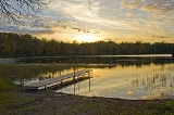
15818 acres (64 km²) of hills, lakes, and bogs now comprise the park. Activities include summer and winter camping, hiking, snowshoeing, and ski touring on the old portage and other trails, mountain biking, and snowmobiling, as well as swimming, fishing, canoeing, and boating on Loon Lake.
Land animals in the area include moose, bear, deer, gray wolves, coyotes, skunks, amphibians, and wood turtles. Birds include bald eagles, sharp-tail grouse, warblers, boreal owls from Canada which winter in the area, sandhill cranes, trumpeter swans, and loons.
State park
State parks are parks or other protected areas managed at the federated state level within those nations which use "state" as a political subdivision. State parks are typically established by a state to preserve a location on account of its natural beauty, historic interest, or recreational...
of Minnesota
Minnesota
Minnesota is a U.S. state located in the Midwestern United States. The twelfth largest state of the U.S., it is the twenty-first most populous, with 5.3 million residents. Minnesota was carved out of the eastern half of the Minnesota Territory and admitted to the Union as the thirty-second state...
, USA, established in 1961 to preserve the historic Savanna Portage, a difficult 6 miles (9.7 km) trail connecting the watersheds of the Mississippi River
Mississippi River
The Mississippi River is the largest river system in North America. Flowing entirely in the United States, this river rises in western Minnesota and meanders slowly southwards for to the Mississippi River Delta at the Gulf of Mexico. With its many tributaries, the Mississippi's watershed drains...
and Lake Superior
Lake Superior
Lake Superior is the largest of the five traditionally-demarcated Great Lakes of North America. It is bounded to the north by the Canadian province of Ontario and the U.S. state of Minnesota, and to the south by the U.S. states of Wisconsin and Michigan. It is the largest freshwater lake in the...
. The park contains a drainage divide separating the West Savanna River
West Savanna River
-References:***USGS Hydrologic Unit Map - State of Minnesota...
, which drains to the Mississippi and the Gulf of Mexico
Gulf of Mexico
The Gulf of Mexico is a partially landlocked ocean basin largely surrounded by the North American continent and the island of Cuba. It is bounded on the northeast, north and northwest by the Gulf Coast of the United States, on the southwest and south by Mexico, and on the southeast by Cuba. In...
, from the East Savanna River
East Savanna River
The East Savanna River is a small yet historic stream in Aitkin and Saint Louis counties in the U.S. state of Minnesota. The stream now rises in Wolf Lake, a small body of water within a spruce bog in Savanna Portage State Park, and flows northeasterly to the Saint Louis River at Floodwood,...
, which flows in an opposite direction to the Saint Louis River
Saint Louis River
The St. Louis River is a river in the U.S. states of Minnesota and Wisconsin that flows into Lake Superior. The largest U.S. river to flow into the lake, it is 179 miles in length and starts near Hoyt Lakes, Minnesota. The river's watershed is in area...
, Lake Superior and the Great Lakes
Great Lakes
The Great Lakes are a collection of freshwater lakes located in northeastern North America, on the Canada – United States border. Consisting of Lakes Superior, Michigan, Huron, Erie, and Ontario, they form the largest group of freshwater lakes on Earth by total surface, coming in second by volume...
, and the Saint Lawrence River
Saint Lawrence River
The Saint Lawrence is a large river flowing approximately from southwest to northeast in the middle latitudes of North America, connecting the Great Lakes with the Atlantic Ocean. It is the primary drainage conveyor of the Great Lakes Basin...
to the Atlantic Ocean
Atlantic Ocean
The Atlantic Ocean is the second-largest of the world's oceanic divisions. With a total area of about , it covers approximately 20% of the Earth's surface and about 26% of its water surface area...
.
Savanna Portage was a canoe
Canoe
A canoe or Canadian canoe is a small narrow boat, typically human-powered, though it may also be powered by sails or small electric or gas motors. Canoes are usually pointed at both bow and stern and are normally open on top, but can be decked over A canoe (North American English) or Canadian...
portage
Portage
Portage or portaging refers to the practice of carrying watercraft or cargo over land to avoid river obstacles, or between two bodies of water. A place where this carrying occurs is also called a portage; a person doing the carrying is called a porter.The English word portage is derived from the...
used by Native Americans
Native Americans in the United States
Native Americans in the United States are the indigenous peoples in North America within the boundaries of the present-day continental United States, parts of Alaska, and the island state of Hawaii. They are composed of numerous, distinct tribes, states, and ethnic groups, many of which survive as...
for centuries before being used by European explorers, fur trade
Fur trade
The fur trade is a worldwide industry dealing in the acquisition and sale of animal fur. Since the establishment of world market for in the early modern period furs of boreal, polar and cold temperate mammalian animals have been the most valued...
rs, Voyageurs
Voyageurs
The Voyageurs were the persons who engaged in the transportation of furs by canoe during the fur trade era. Voyageur is a French word which literally translates to "traveler"...
, coureurs des bois
Coureur des bois
A coureur des bois or coureur de bois was an independent entrepreneurial French-Canadian woodsman who traveled in New France and the interior of North America. They travelled in the woods to trade various things for fur....
, and missionaries of the 18th and 19th centuries. It was a vital link connecting the Mississippi waterways to the west with the Great Lakes
Great Lakes
The Great Lakes are a collection of freshwater lakes located in northeastern North America, on the Canada – United States border. Consisting of Lakes Superior, Michigan, Huron, Erie, and Ontario, they form the largest group of freshwater lakes on Earth by total surface, coming in second by volume...
to the east. The portage is listed in the National Register of Historic Places
National Register of Historic Places
The National Register of Historic Places is the United States government's official list of districts, sites, buildings, structures, and objects deemed worthy of preservation...
. The park which now contains it is located 17 miles (27.4 km) north and east of McGregor, Minnesota
McGregor, Minnesota
As of the census of 2000, there were 404 people, 182 households, and 105 families residing in the city. The population density was 205.5 people per square mile . There were 199 housing units at an average density of 101.2 per square mile...
, and approximately 50 miles (80.5 km) west of Duluth
Duluth, Minnesota
Duluth is a port city in the U.S. state of Minnesota and is the county seat of Saint Louis County. The fourth largest city in Minnesota, Duluth had a total population of 86,265 in the 2010 census. Duluth is also the second largest city that is located on Lake Superior after Thunder Bay, Ontario,...
.
Geology and topography
The park is located on the divide between the watershedDrainage basin
A drainage basin is an extent or an area of land where surface water from rain and melting snow or ice converges to a single point, usually the exit of the basin, where the waters join another waterbody, such as a river, lake, reservoir, estuary, wetland, sea, or ocean...
s of the Great Lakes
Great Lakes
The Great Lakes are a collection of freshwater lakes located in northeastern North America, on the Canada – United States border. Consisting of Lakes Superior, Michigan, Huron, Erie, and Ontario, they form the largest group of freshwater lakes on Earth by total surface, coming in second by volume...
and the Gulf of Mexico, both of which drain to the Atlantic Ocean
Atlantic Ocean
The Atlantic Ocean is the second-largest of the world's oceanic divisions. With a total area of about , it covers approximately 20% of the Earth's surface and about 26% of its water surface area...
. The area is a low-relief plain which was once a glacial lake
Glacial lake
A glacial lake is a lake with origins in a melted glacier. Near the end of the last glacial period, roughly 10,000 years ago, glaciers began to retreat. A retreating glacier often left behind large deposits of ice in hollows between drumlins or hills. As the ice age ended, these melted to create...
bed. During the last phase of the Wisconsinan glaciation
Wisconsinan glaciation
The Wisconsin Glacial Episode was the most recent major advance of the North American Laurentide ice sheet. Globally, this advance is known as the last glacial period. The Wisconsin glaciation extended from approximately 110,000 to 10,000 years ago, between the Eemian interglacial and the current...
, the deteriorating continental glacier left behind connected lakes, known as Glacial Lakes Aitkin and Upham. Formed by the retreat of the St. Louis Sublobe of the Superior Lobe of the glacier, Lake Upham drained through Lake Aitkin to the Mississippi River. The retreating glacier and the lakes deposited sand and sediments in the lakebed. As the lakes drained these sediments became the present plain.
The plain at first was drained by the Cloquet River
Cloquet River
The Cloquet River is a river of Minnesota. It is the main tributary of the St. Louis River.-Geography:The Cloquet river generally flows in a southwesterly direction which goes through Alden Lake, Island Lake Reservoir and Wood Lake before emptying into the St...
, which then ran west to the Mississippi. By the process of stream piracy, the smaller Saint Louis River, which runs to Lake Superior, captured the Cloquet and most of its drainage basin. This left behind the East Savanna River
East Savanna River
The East Savanna River is a small yet historic stream in Aitkin and Saint Louis counties in the U.S. state of Minnesota. The stream now rises in Wolf Lake, a small body of water within a spruce bog in Savanna Portage State Park, and flows northeasterly to the Saint Louis River at Floodwood,...
which drains into the St. Louis, Lake Superior, the lower Great Lakes, and the Saint Lawrence River, and to the west, the West Savanna River
West Savanna River
-References:***USGS Hydrologic Unit Map - State of Minnesota...
, which is tributary to the Mississippi.
The old lake plain is part of the Tamarack Lowlands Subsection within the Northern Minnesota Drift Plains Section of the Laurentian Mixed Forest. Lacustrine
Lake
A lake is a body of relatively still fresh or salt water of considerable size, localized in a basin, that is surrounded by land. Lakes are inland and not part of the ocean and therefore are distinct from lagoons, and are larger and deeper than ponds. Lakes can be contrasted with rivers or streams,...
sediments deposited by the glacial lake are parent to the present soils of peats, silt, and sand; the peats are in marshes which form large parts of the park. These wet lowlands adjoin rolling hills which are end moraines of the recent glaciation. These moraines are part of the St. Louis Moraines Subdivision of the Northern Minnesota Drift Plain.
Savanna Portage
The plain in the old lakebed provided a low-grade but very swampy overland route across the divide between the East and West Savanna Rivers. Wolf Lake, source of the East Savanna, is only about 800 yards (731.5 m) east of Savanna Lake on the West Savanna. As Wolf Lake and the upper East Savanna are very swampy, the route selected for the portage trail departed from the river further downstream, shortening the distance to be traveled through the bog. The portage, some 6 miles (9.7 km) long, starts in the swamp and then goes west in a wooded upland to reach the West Savanna.Long used by Native Americans, it became a thoroughfare between the Great Lakes and the Mississippi Valley for explorers, missionaries, and fur traders. Travelers from the east exited Lake Superior near Fond du Lac
Fond du Lac (Duluth)
Fond du Lac is a neighborhood in Duluth, Minnesota, United States.Evergreen Memorial Highway serves as a main arterial route in the community.-History:...
("head of the lake", where Duluth
Duluth, Minnesota
Duluth is a port city in the U.S. state of Minnesota and is the county seat of Saint Louis County. The fourth largest city in Minnesota, Duluth had a total population of 86,265 in the 2010 census. Duluth is also the second largest city that is located on Lake Superior after Thunder Bay, Ontario,...
is now located), and ascended the steep, rocky, and difficult gorge of the lower Saint Louis River, which falls some 450 feet (137.2 m) from the location of Carlton, Minnesota
Carlton, Minnesota
Carlton is a city in Carlton County, Minnesota, United States. The population was 862 at the 2010 census. It is the county seat of Carlton County.Minnesota State Highways 45 and 210; and County Roads 1 and 3 are four of the main routes in the community....
, through what is now Jay Cooke State Park
Jay Cooke State Park
Jay Cooke State Park is a Minnesota state park located about ten miles southwest of Duluth, just outside the small town of Thomson. Jay Cooke is situated on the St...
to its outlet at the lake. Above Carlton travelers proceeded upstream through quieter stretches to the location of Floodwood, Minnesota
Floodwood, Minnesota
As of the census of 2000, there were 503 people , 254 households, and 112 families residing in the city. The population density was 1,131.9 people per square mile . There were 290 housing units at an average density of 652.6 per square mile...
, where they turned southwest up the sluggish East Savanna River in the bed of Glacial Lake Upham. Coming to a small rise, the travelers commenced the portage, which in its eastern reaches was marshy, mosquito-infested, and among the most unpleasant and even tortuous of all the routes taken by the voyageurs. Struggling waist-deep through the morass of the "boundless swamp", travelers eventually reached a hardwood forest, through which the trail ran to the West Savanna River, which drains to Big Sandy Lake
Big Sandy Lake
There is another Big Sandy Lake, crossed by U.S. Highway 80 in Big Sandy, Texas.Big Sandy Lake is a lake in Aitkin County, Minnesota, approximately nine miles north of McGregor. The lake is considered fertile walleye ground with several habitat types, including the open main basin, the deep, cold...
and the Upper Mississippi.
The portage likely was used by Europeans as early as 1679, when Daniel Greysolon, Sieur du Lhut
Daniel Greysolon, Sieur du Lhut
Daniel Greysolon, Sieur du Lhut was a French soldier and explorer who is the first European known to have visited the area where the city of Duluth, Minnesota is now located and the headwaters of the Mississippi River near Grand Rapids...
visited a Sioux
Sioux
The Sioux are Native American and First Nations people in North America. The term can refer to any ethnic group within the Great Sioux Nation or any of the nation's many language dialects...
village at Big Sandy Lake during his exploration of the Lake Superior region and the Upper Mississippi. Among the portage's users were fur traders who operated in the upper Mississippi valley. Some went no further than the American Fur Company
American Fur Company
The American Fur Company was founded by John Jacob Astor in 1808. The company grew to monopolize the fur trade in the United States by 1830, and became one of the largest businesses in the country. The company was one the first great trusts in American business...
's large regional trading post on Big Sandy Lake operated by William Aitkin in the 1820s and 1830s, the years of peak usage of the route. Explorers and scientists crossing the portage included David Thompson
David Thompson (explorer)
David Thompson was an English-Canadian fur trader, surveyor, and map-maker, known to some native peoples as "Koo-Koo-Sint" or "the Stargazer"...
, British explorer of Canada and North West Fur Company cartographer, in 1798; Zebulon Pike
Zebulon Pike
Zebulon Montgomery Pike Jr. was an American officer and explorer for whom Pikes Peak in Colorado is named. As a United States Army captain in 1806-1807, he led the Pike Expedition to explore and document the southern portion of the Louisiana Purchase and to find the headwaters of the Red River,...
, early explorer of the American west, in 1805; Lewis Cass
Lewis Cass
Lewis Cass was an American military officer and politician. During his long political career, Cass served as a governor of the Michigan Territory, an American ambassador, a U.S. Senator representing Michigan, and co-founder as well as first Masonic Grand Master of the Grand Lodge of Michigan...
, American general and explorer, in his unsuccessful 1820 search for the source of the Mississippi River; Henry Schoolcraft
Henry Schoolcraft
Henry Rowe Schoolcraft was an American geographer, geologist, and ethnologist, noted for his early studies of Native American cultures, as well as for his 1832 discovery of the source of the Mississippi River. He married Jane Johnston, whose parents were Ojibwe and Scots-Irish...
, geologist and explorer, who accompanied Cass in 1820 and led an expedition in 1832 to find the Mississippi's source; Joseph Nicollet
Joseph Nicollet
Joseph Nicolas Nicollet , also known as Jean-Nicolas Nicollet, was a French geographer and mathematician known for mapping the Upper Mississippi River basin during the 1830s....
, French geographer and cartographer of the Upper Mississippi, in 1836; and Laurence Oliphant, a British explorer and writer, in 1854. Tourists such as Count Ferdinand von Zeppelin
Ferdinand von Zeppelin
Ferdinand Adolf Heinrich August Graf von Zeppelin was a German general and later aircraft manufacturer. He founded the Zeppelin Airship company...
, who crossed in 1863, also used the portage.
When the Northern Pacific Railroad, building west from Duluth
Duluth, Minnesota
Duluth is a port city in the U.S. state of Minnesota and is the county seat of Saint Louis County. The fourth largest city in Minnesota, Duluth had a total population of 86,265 in the 2010 census. Duluth is also the second largest city that is located on Lake Superior after Thunder Bay, Ontario,...
, reached nearby McGregor
McGregor, Minnesota
As of the census of 2000, there were 404 people, 182 households, and 105 families residing in the city. The population density was 205.5 people per square mile . There were 199 housing units at an average density of 101.2 per square mile...
in 1870, the portage fell out of use for through traffic, but continued to be used for local trade and access to the interior. The trail's location was traced and marked in 1926 and in the 1940s through the 1960s, and with the use of archaeological techniques, it was more precisely marked in 1981. Much of the route is now maintained as a hiking trail.
State park
The interest created by investigations into the trail's route inspired creation of Savanna Portage State Park in 1961. At some 14000 acres (56.7 km²), it became the third-largest park in the system. It included within it the Floodwood Game Refuge; the park in turn is nearly surrounded by the Savanna State Forest. It is some 13.5 miles (21.7 km) long and nowhere more than 4 miles (6.4 km) wide, its shape being dictated in part by the portage corridor.15818 acres (64 km²) of hills, lakes, and bogs now comprise the park. Activities include summer and winter camping, hiking, snowshoeing, and ski touring on the old portage and other trails, mountain biking, and snowmobiling, as well as swimming, fishing, canoeing, and boating on Loon Lake.
Flora and fauna
Named for its open marshy grassland, the park's peat bogs and marshes include sedges and black spruce, tamarack, and white cedar. Uplands host a mixed hardwood and conifer forest of maple, oak, poplar, birch, white pine, and red pine.Land animals in the area include moose, bear, deer, gray wolves, coyotes, skunks, amphibians, and wood turtles. Birds include bald eagles, sharp-tail grouse, warblers, boreal owls from Canada which winter in the area, sandhill cranes, trumpeter swans, and loons.