

Sajama Lines
Encyclopedia
Bolivia
Bolivia officially known as Plurinational State of Bolivia , is a landlocked country in central South America. It is the poorest country in South America...
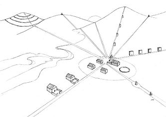
are a network of thousands (possibly tens of thousands) of nearly perfectly straight paths etched into the ground continuously for more than 3,000 years by the indigenous people living near Nevado Sajama
Nevado Sajama
Nevado Sajama is an extinct stratovolcano and the highest peak in Bolivia. The mountain is located in the Oruro Department, Sajama Province, Curahuara de Carangas Municipality, Sajama Canton. It is situated in the Sajama National Park in the southwest area of the country some 16–24 km from...
. They form a web-like network that blankets the Altiplano
Altiplano
The Altiplano , in west-central South America, where the Andes are at their widest, is the most extensive area of high plateau on Earth outside of Tibet...
.
Characteristics
Recent research revealed that this network of lines covers an area of 22,525 square kilometers, approximately fifteen times larger than the area covered by the Nazca LinesNazca Lines
The Nazca Lines are a series of ancient geoglyphs located in the Nazca Desert in southern Peru. They were designated a UNESCO World Heritage Site in 1994. The high, arid plateau stretches more than between the towns of Nazca and Palpa on the Pampas de Jumana about 400 km south of Lima...
in Peru
Peru
Peru , officially the Republic of Peru , is a country in western South America. It is bordered on the north by Ecuador and Colombia, on the east by Brazil, on the southeast by Bolivia, on the south by Chile, and on the west by the Pacific Ocean....
. Rough estimates put their linear length at approximately 16,000 kilometers, roughly three times the breadth of the United States
United States
The United States of America is a federal constitutional republic comprising fifty states and a federal district...
. As such, the Sajama Lines are the largest archaeological site in the Andes
Andes
The Andes is the world's longest continental mountain range. It is a continual range of highlands along the western coast of South America. This range is about long, about to wide , and of an average height of about .Along its length, the Andes is split into several ranges, which are separated...
and might be considered the largest artwork
Visual arts
The visual arts are art forms that create works which are primarily visual in nature, such as ceramics, drawing, painting, sculpture, printmaking, design, crafts, and often modern visual arts and architecture...
in the world.
The lines were created by scraping aside vegetation
Vegetation
Vegetation is a general term for the plant life of a region; it refers to the ground cover provided by plants. It is a general term, without specific reference to particular taxa, life forms, structure, spatial extent, or any other specific botanical or geographic characteristics. It is broader...
and the dark surface material consisting of soil
Soil
Soil is a natural body consisting of layers of mineral constituents of variable thicknesses, which differ from the parent materials in their morphological, physical, chemical, and mineralogical characteristics...
and oxidized rock
Rock (geology)
In geology, rock or stone is a naturally occurring solid aggregate of minerals and/or mineraloids.The Earth's outer solid layer, the lithosphere, is made of rock. In general rocks are of three types, namely, igneous, sedimentary, and metamorphic...
and exposing the lighter subsurface material. Like the better-known Nazca Lines (which differ from the Sajama Lines in that some of the Nazca are depictions of animals) neither the purpose of these lines, nor how the makers achieved such precision, are completely understood.
Scholars at the University of Pennsylvania
University of Pennsylvania
The University of Pennsylvania is a private, Ivy League university located in Philadelphia, Pennsylvania, United States. Penn is the fourth-oldest institution of higher education in the United States,Penn is the fourth-oldest using the founding dates claimed by each institution...
describe:
While many of these sacred lines extend as far as ten or twenty kilometers (and perhaps further), they all seem to maintain a remarkable straightness despite rugged topography and natural obstacles. The sheer number and length of these lines is often difficult to perceive from ground level, but from the air or hilltop vantage points, they are stunning.
Many believe that the lines were originally used by indigenous people when they made sacred
Sacred
Holiness, or sanctity, is in general the state of being holy or sacred...
pilgrimage
Pilgrimage
A pilgrimage is a journey or search of great moral or spiritual significance. Typically, it is a journey to a shrine or other location of importance to a person's beliefs and faith...
s. Interspersed among this network of radial lines and aligned to where lines meet are huacas (shrine
Shrine
A shrine is a holy or sacred place, which is dedicated to a specific deity, ancestor, hero, martyr, saint, daemon or similar figure of awe and respect, at which they are venerated or worshipped. Shrines often contain idols, relics, or other such objects associated with the figure being venerated....
s), chullpas (burial
Burial
Burial is the act of placing a person or object into the ground. This is accomplished by excavating a pit or trench, placing an object in it, and covering it over.-History:...
tower
Tower
A tower is a tall structure, usually taller than it is wide, often by a significant margin. Towers are distinguished from masts by their lack of guy-wires....
s) and hamlet
Hamlet
The Tragical History of Hamlet, Prince of Denmark, or more simply Hamlet, is a tragedy by William Shakespeare, believed to have been written between 1599 and 1601...
s, making the area a unique cultural landscape. Though the region is now sparsely populated there is evidence that some of the lines are still in use as footpath
Trail
A trail is a path with a rough beaten or dirt/stone surface used for travel. Trails may be for use only by walkers and in some places are the main access route to remote settlements...
s.
Analysis and preservation
The earliest account of the Sajama Lines in EnglishEnglish language
English is a West Germanic language that arose in the Anglo-Saxon kingdoms of England and spread into what was to become south-east Scotland under the influence of the Anglian medieval kingdom of Northumbria...
is a brief reference by traveler Aimé Felix Tschiffely
Aimé Félix Tschiffely
Aimé Félix Tschiffely was a Swiss-born, Argentine professor, writer, and adventurer. A.F. Tschiffely wrote a number of books, most famously Tschiffely's Ride in which he recounts his solo journey on horseback from Argentina to Washington DC, an epic adventure that still marks one of the greatest...
in 1932. That same decade, anthropologist Alfred Metraux
Alfred Metraux
Alfred Métraux was a Swiss anthropologist and human rights leader.-Early life:Born in Lausanne, Switzerland, Metraux spent much of his childhood in Argentina where his father was a well known surgeon resident in Mendoza. His mother was a Georgian from Tbilisi...
brought the lines and associated structures to the attention of scholars when he published ethnographic
Ethnography
Ethnography is a qualitative method aimed to learn and understand cultural phenomena which reflect the knowledge and system of meanings guiding the life of a cultural group...
fieldwork about the Aymara and Chipaya people of the Carangas region.
In the 1970s British
United Kingdom
The United Kingdom of Great Britain and Northern IrelandIn the United Kingdom and Dependencies, other languages have been officially recognised as legitimate autochthonous languages under the European Charter for Regional or Minority Languages...
writer
Writer
A writer is a person who produces literature, such as novels, short stories, plays, screenplays, poetry, or other literary art. Skilled writers are able to use language to portray ideas and images....
and filmmaker Tony Morrison reported on this network of sacred lines and roadways. In recent years, organizations such as the Landmarks Foundation
Landmarks Foundation
Landmarks Foundation, founded in 1997 and based in New York City, is a non-profit organization created to conserve sacred sites and landscapes around the world...
have studied and map
Map
A map is a visual representation of an area—a symbolic depiction highlighting relationships between elements of that space such as objects, regions, and themes....
ped the Sajama Lines to create a database
Database
A database is an organized collection of data for one or more purposes, usually in digital form. The data are typically organized to model relevant aspects of reality , in a way that supports processes requiring this information...
to help protect the landscape from threats of erosion
Erosion
Erosion is when materials are removed from the surface and changed into something else. It only works by hydraulic actions and transport of solids in the natural environment, and leads to the deposition of these materials elsewhere...
, unchecked internationally financed development and tourism
Tourism
Tourism is travel for recreational, leisure or business purposes. The World Tourism Organization defines tourists as people "traveling to and staying in places outside their usual environment for not more than one consecutive year for leisure, business and other purposes".Tourism has become a...
in the area, and other dangers that come from the absence of a management plan.
The Landmarks Foundation worked with the University of Pennsylvania to develop the "Tierra Sajama project" which used geographic information system
Geographic Information System
A geographic information system, geographical information science, or geospatial information studies is a system designed to capture, store, manipulate, analyze, manage, and present all types of geographically referenced data...
s (GIS) and other analytic digital media tools to map, describe, and analyze the Sajama Lines and their associated structures in order to offer strategies to protect and promote the Lines in the future. The Tierra Sajama project:
- Created a computer-database of maps and pertinent information about the lines, local vegetation, and relevant topographyTopographyTopography is the study of Earth's surface shape and features or those ofplanets, moons, and asteroids...
- Analyzed and interpreted the patterns and meanings of various land features such as mountaintop shrines and religious structures to determine possible alignments to the sacred Lines
- Developed proposals that provided for long-term protection of the Lines and enhanced appreciation of the sacred landscape
According to Tierra Sajama participants:
The Sajama Lines are extraordinary examples of human achievement and spiritual expression. With proper preservation and management, responsible development, erosion prevention and measures to minimize vandalismVandalismVandalism is the behaviour attributed originally to the Vandals, by the Romans, in respect of culture: ruthless destruction or spoiling of anything beautiful or venerable...
the Sajama Lines can be protected to the benefit of tourists from all over the world as well as the local people.
Select bibliography
- Aveni, Anthony. Between the Lines: The Mystery of the Giant Ground Drawings of Ancient Nasca, Peru. Austin, Texas: University of Texas Press, 2000
- Bauer, Brian. The Sacred Landscape of the Inca: The Cusco Ceque System. University of Texas Press, Austin, 1998.
See also
- Coordinates: 18°16′08"S 68°42′18"W (One sample area where the paths are visible by satellite.)